A Wet Saturday

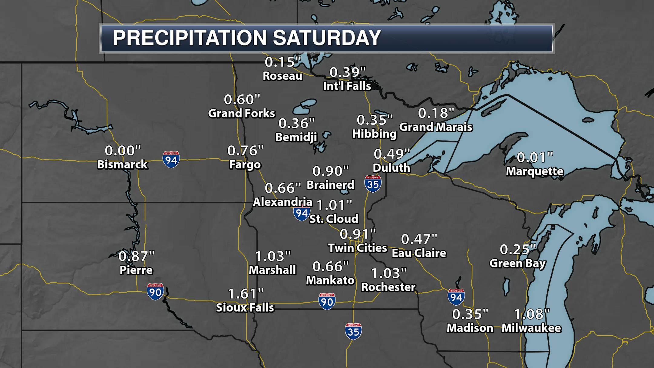
To end the month of April on Saturday we saw just a continuation of the weather we saw through the rest of the month - below-average temperatures and wet! On the rainy side of that equation, the Twin Cities picked up another 0.91" of rain, with over an inch falling in St. Cloud, Rochester, and Marshall. The rainiest airport was out in Canby where 1.40" fell. Of course, May started off on a wet note as well on Sunday. More on the wet and cool April in a moment.

_______________________________________________

Cloudy - But Dry - Monday

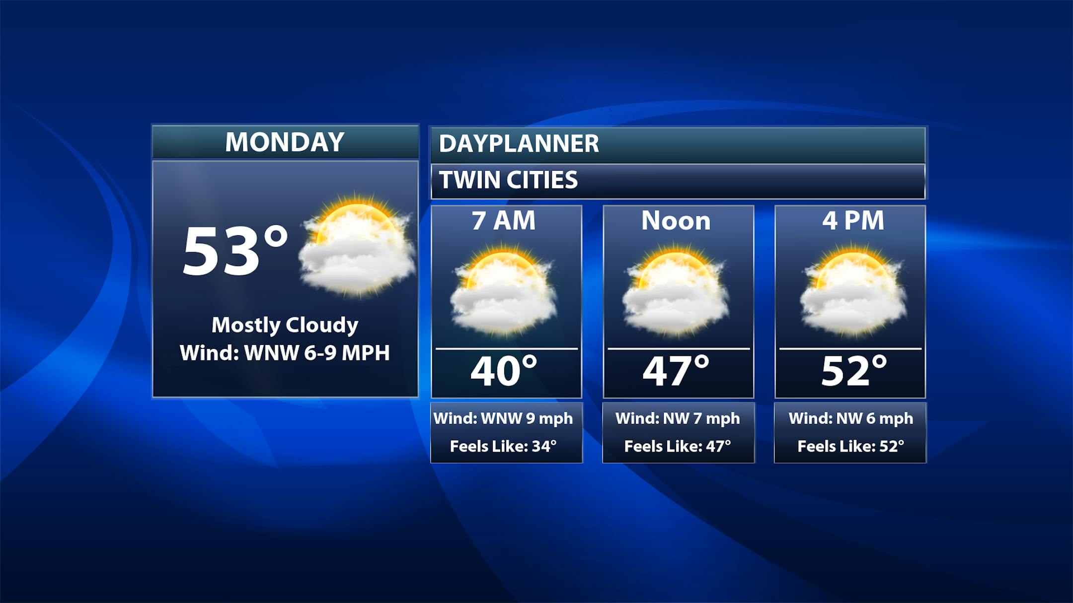
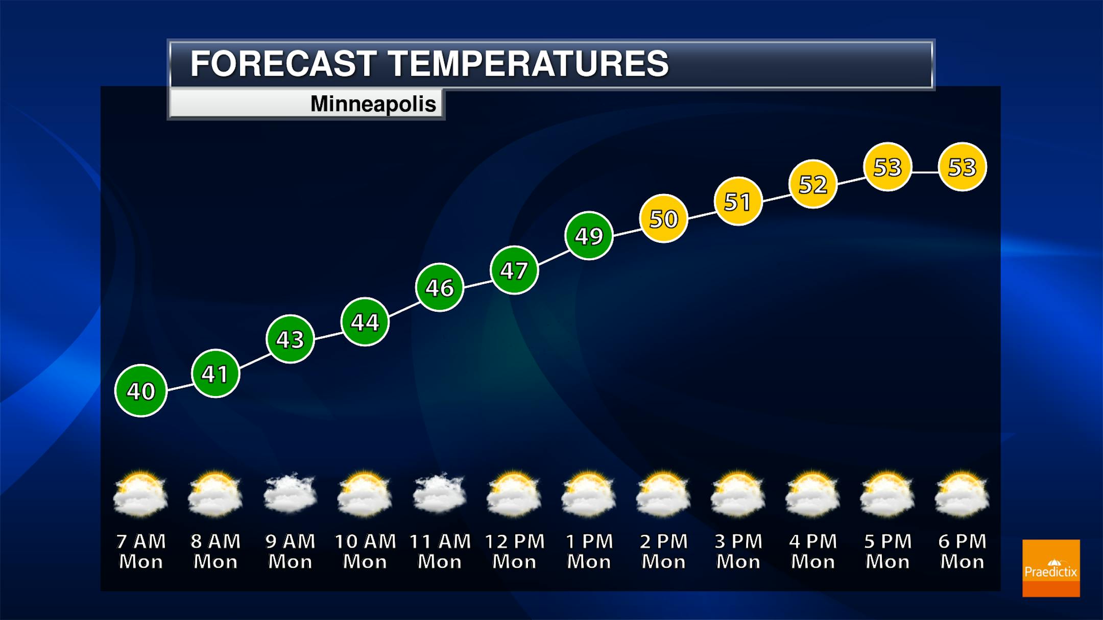
After a rainy weekend, we'll shed the rain but keep the clouds around on Monday in the Twin Cities. Morning temperatures will start off right around 40F with highs climbing into the low 50s. To note, our average high for May 2nd is 65F.

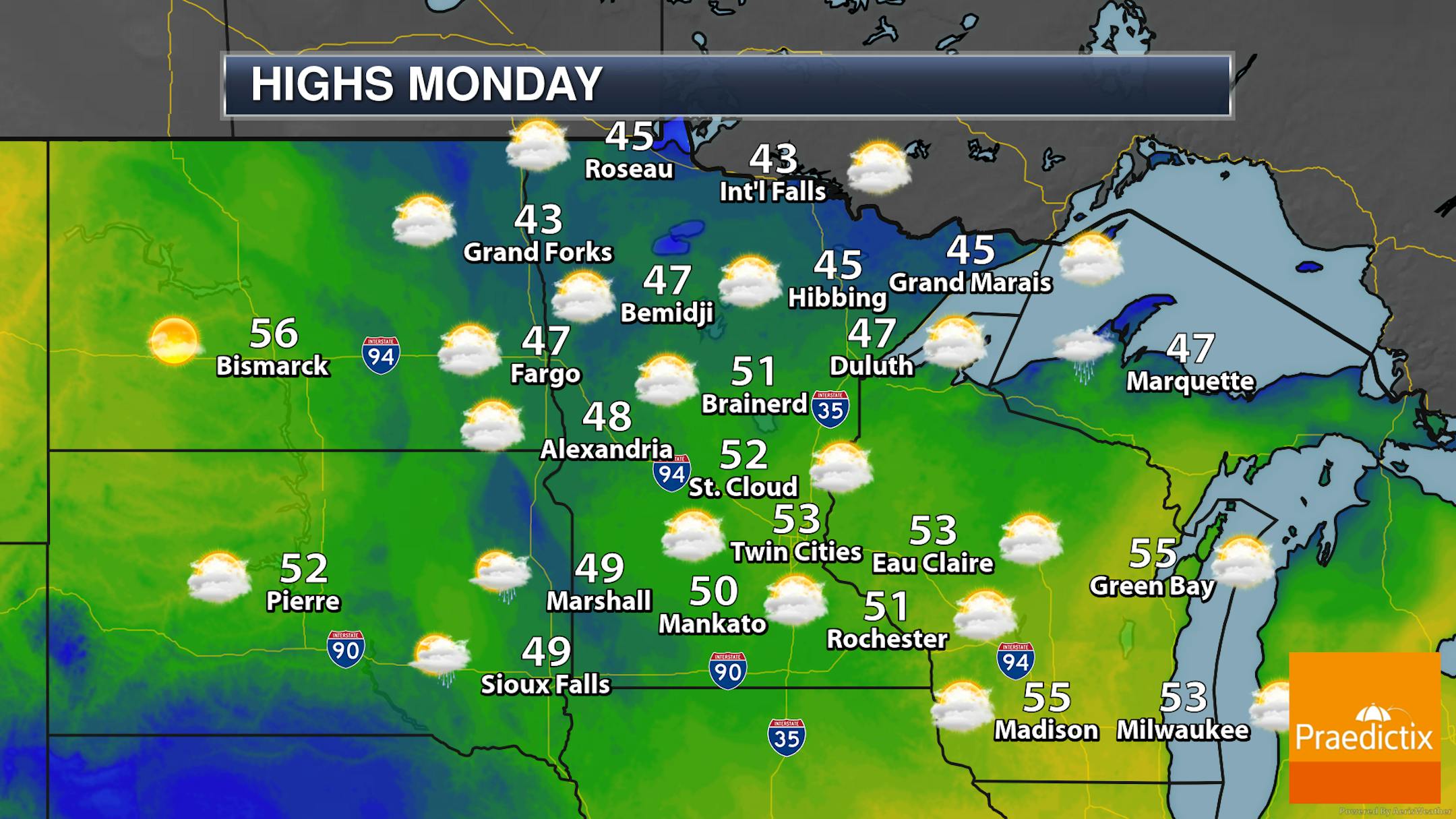
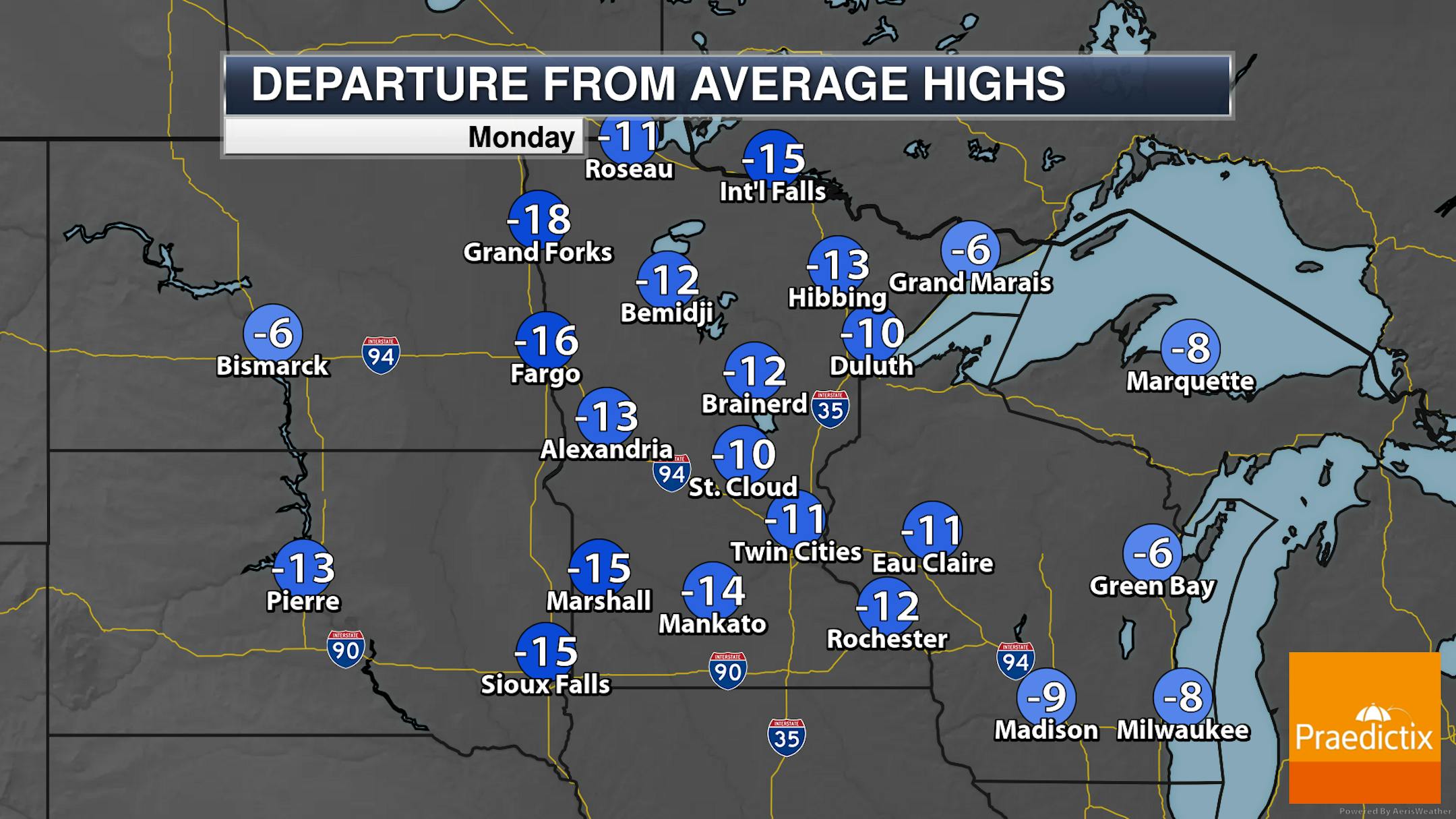
40s and 50s statewide are expected Monday with a lot of clouds. Not much to say besides how these temperatures once again are 5-15F degrees below average.

_______________________________________________

Below Average Highs This Week... But We Make It Back To The 60s!

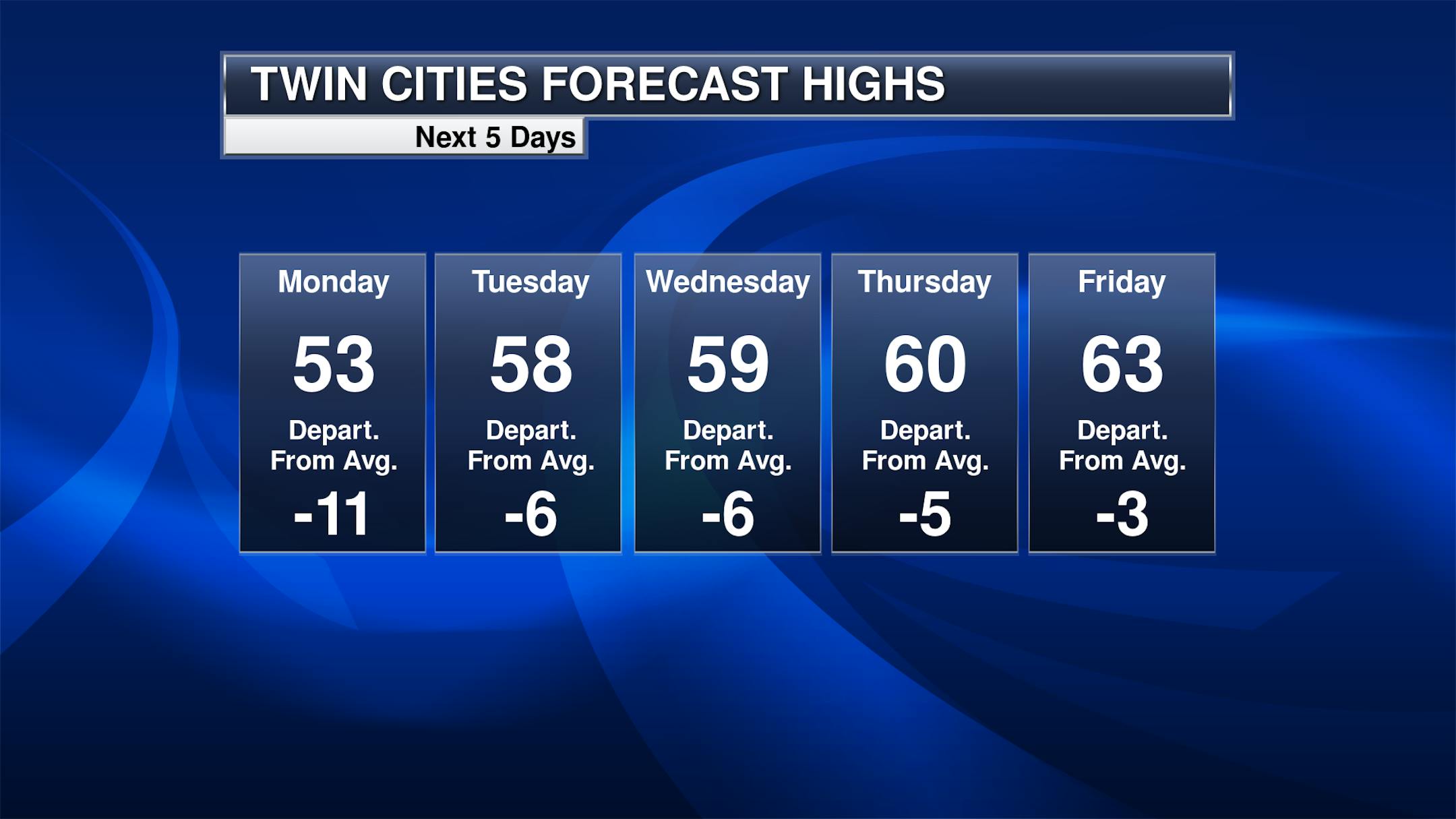
The good news is that we see warming temperatures as we head throughout the week, with 50s for the first half and 60s by Thursday and Friday. The upsetting news is that these temperatures are still several degrees below average for the first week of May. Signs show highs remaining in the 60s next weekend. We do watch a couple of slight chances of rain this week - one Monday Night into Tuesday, and another Wednesday Night into early Friday. Most of the precipitation with both these chances looks to remain south of the region.

_______________________________________________

Snow Still In Parts Of Northern Minnesota

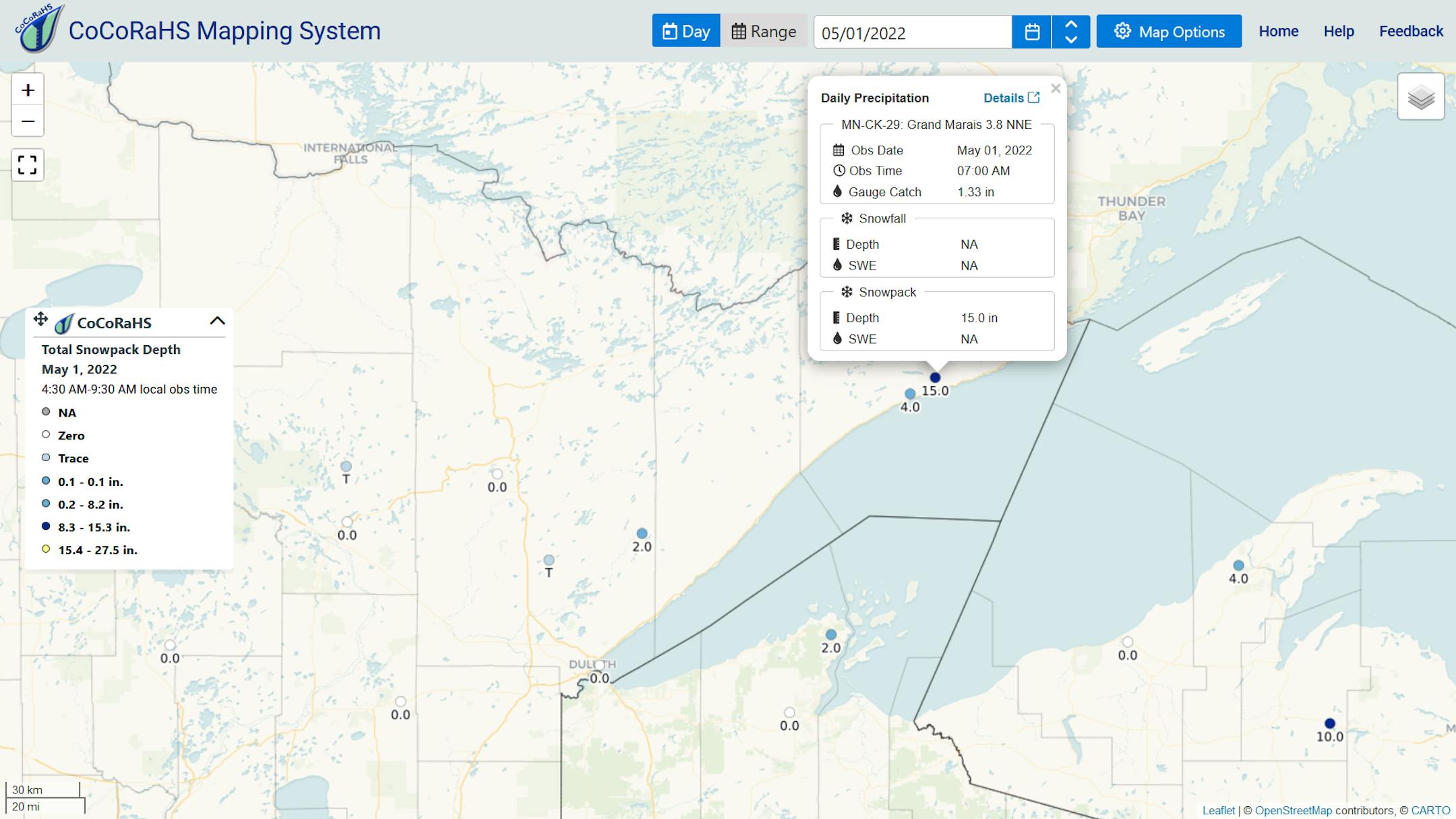
Meanwhile, yes, there is still snow on the ground up in parts of northern Minnesota! The CoCoRaHS reporter 3.8 miles north-northeast of Grand Marais reported 15" of snow depth Sunday morning.

_______________________________________________

A Wet, Cool April Summary

It was a cool, wet April in the Twin Cities - but not all that snowy. This April ends up as the 16th wettest and 14th coldest for MSP with almost 4" of liquid precipitation and an average temperature that was 6.1F below average.

As we look at climate site data maintained by the NWS in the Twin Cities, that cool, wet, and not-so-snowy trend continues when looking at St. Cloud and Eau Claire. In St. Cloud, it was the 20th wettest and 17th coldest. For Eau Claire, it was the 8th wettest and 16th coldest.

Looking northward, International Falls saw their wettest April on record (and 11th overall wettest month) with 7.61" of liquid. Remember precipitation includes rain and melted wintry precipitation. They also saw a lot of snow - 17.1", the 7th snowiest April on record. The 19.2" of snow at Duluth was also their 7th snowiest April, with 4.02" of liquid making it the 17th wettest April.

Lots of precipitation fell across the state in April, with some of the heaviest in northern and eastern portions. All climate locations ended the month above average.

And here's a look at April snow across the state - with below-average values in central and southern Minnesota, but far above-average amounts up north.

_______________________________________________

Precipitation So Far This Spring

All climate locations across the state are also running above-average in the precipitation department so far this Meteorological Spring (March 1 through May 31), with the Twin Cities through the first two months at 2.35" above average.

_______________________________________________

Growing Risk of Spring Warmth This Week
By Paul Douglas

Too cool for tornadoes (check). Large parts of our state are not on fire (check). No more drought; ample water in our lakes and fields (check). Then why don't we feel better?

Our spring has been an atmospheric virus of clouds, wind and incessant chill. At 6.1F colder than average it was the Twin Cities 14th coolest and 16th wettest April on record, with nearly 4" of precipitation. Only 1.6" slush at MSP but it was the 7th snowiest April in both Duluth (19.2") and International Falls (17.1"). This year spring has tested our goodwill and optimism.

But every weather pattern, however blissful and lousy, comes to an end. After too many false starts, spring warmth may finally stick around this time. 60s return midweek with a good shot of 70 degrees by Mother's Day. No more Gales of November, but showers brush southern counties late Thursday with rumbles of thunder early next week.

Paranoid? Weather records show that cool springs do not mean a cool summer is inevitable. Do not rule out a parade of hot fronts.

_______________________________________________

Paul's Extended Twin Cities Forecast

MONDAY: Mostly cloudy and dry. Wake up 40. High 53. Chance of precipitation 10%. Wind NW 7-12 mph.

TUESDAY: Some sunshine, cool breeze. Wake up 40. High 57. Chance of precipitation 20%. Wind NE 10-20 mph.

WEDNESDAY: Sunny and pleasant. Wake up 38. High 61. Chance of precipitation 0%. Wind E 5-10 mph.

THURSDAY: Clouds increase, late showers? Wake up 45. High 59. Chance of precipitation 40%. Wind SE 7-12 mph.

FRIDAY: Damp start, PM clearing. Wake up 49. High 66. Chance of precipitation 20%. Wind NE 10-15 mph.

SATURDAY: Lukewarm sunshine. Wake up 44. High 68. Chance of precipitation 10%. Wind SE 5-10 mph.

SUNDAY: Fading sunshine, feels like May. Wake up 48. High 70. Chance of precipitation 20%. Wind SE 10-15 mph.

_______________________________________________

Minneapolis Weather Almanac And Sun Data
May 2nd

*Length Of Day: 14 hours, 19 minutes, and 5 seconds
*Daylight GAINED Since Yesterday: 2 minutes and 42 seconds

*When Do We See 15 Hours Of Daylight: May 19th (15 hours, 0 minutes, 10 seconds)
*When Is The Sunrise At/Before 5:30 AM?: May 30th (5:30 AM)
*When Is The Sunset At/After 8:30 PM?: May 10th (8:30 PM)

_______________________________________________

This Day in Weather History
May 2nd

2013: A historic snowstorm dumps up to 18 inches of snow in southeast Minnesota and west central Wisconsin. Blooming Prairie receives 18 inches from this storm, and Eau Claire gets 9.3 inches.

_______________________________________________

National Weather Forecast

On Monday, a system in the central United States will bring showers and storms - some of which could be strong to severe in the central and southern Plains. An area of low pressure moving across the Northeast (offshore by the evening) will bring some rain chances to the region, as well as to the eastern Mid-Atlantic due to a trailing cold front. A system in the Pacific Northwest will bring rain and some higher elevation snow to begin the week.

Heavy rain will also be possible the next few days across the central and southern Plains, with the potential that rainfall amounts could reach 3" for some through Tuesday evening. Some snow out toward the Rockies and Cascades could tally up to several inches.

_______________________________________________

Nearby star system hosts two planets and 30 exocomets

More from CNN: "The nearby Beta Pictoris planetary system, located 63 light-years away from us, has fascinated researchers for decades. Now, astronomers have found 30 exocomets, or comets located outside of our solar system, orbiting the sunlike Beta Pictoris star, which makes it even more intriguing. The Beta Pictoris star was discovered nearly 40 years ago. It is surrounded by a debris disk made of gas and dust, which has already birthed two young planets that orbit the star. It offers researchers a rare chance to watch a planetary system that's in the process of forming. While our solar system is 4.5 billion years old, Beta Pictoris is only 20 million years old — which is young, astronomically speaking."

Changing climate impacts biodiversity in protected areas globally

More from the US Forest Service: "Protected areas — such as nature reserves, national parks, and wilderness areas — are essential to conserving biodiversity. New research published in Environmental Research Letters provides insights for developing climate-smart conservation strategies. The study looked at the global network of protected areas, evaluated potential for shifts in where plants and animals occur due to climate change, and as a result identifies the need for strategic conservation plans that transcend international borders and protect at-risk species. "As the planet continues to warm, we expect a number of species to move out of some protected areas and into others as they shift their ranges in response to climate change," says lead-author Sean Parks, a research ecologist with the USDA Forest Service Rocky Mountain Research Station, Aldo Leopold Wilderness Research Institute."

Risk of risk of intense tropical cyclones will double by 2050

More from the University of Southampton: "Human-caused climate change will make strong tropical cyclones twice as frequent by the middle of the century, putting large parts of the world at risk, according to a new study published in Scientific Advances. The analysis also projects that maximum wind speeds associated with these cyclones could increase by around 20%. Despite being amongst the world's most destructive extreme weather events, tropical cyclones are relatively rare. In a given year, only around 80-100 tropical cyclones form globally, most of which never make landfall. In addition, accurate global historical records are scarce, making it hard to predict where they will occur and what actions Governments should take to prepare."

_______________________________________________

Thanks for checking in and have a great day! Don't forget to follow me on Twitter (@dkayserwx) and like me on Facebook (Meteorologist D.J. Kayser).

- D.J. Kayser