83rd Anniversary of the Armistice Day Blizzard

Today is the 83rd Anniversary of the November 11th, 1940 Armistice Day Blizzard. This storm resulted in 154 fatalities, with 49 in Minnesota alone. The storm caused significant losses, including over a million turkeys bound for Thanksgiving tables, valued at over half a million dollars, and the death of 1,500 cattle and 2,000 sheep in Iowa. Criticism from Minnesota Governor Harold Stassen and Congressman R. T. Buckler prompted changes, leading to the establishment of a 24-hour forecast office in the state. The storm ranks second on both the Minnesota State Climatology Office's Top Ten Weather Events of the 20th Century and NOAA's list of top blizzards in the United States.

Weather Outlook Through Midday Thursday

Here's the simulated radar through midday Sunday, which shows most dry conditions across the region through the weekend. There could be a few light rain or snow showers across parts of the region, but most of the weekend will be dry.

Precipitation Outlook

The extended precipitation outlook through the weekend shows very minimal precipitation. Much of the region will stay dry with only a few hundredths possible north and east of the metro.

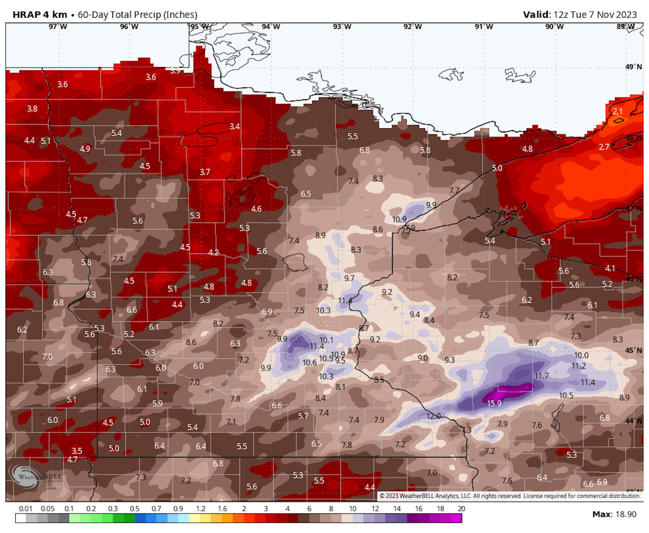
Precipitation Over The Last 60 Days

Extraordinary levels of rainfall have been witnessed in various regions of the state since September 23rd. Remarkably, specific areas in the vicinity of the Twin Cities, delineated in white and blue, have received nearly 10 inches or more of precipitation in just over a month.

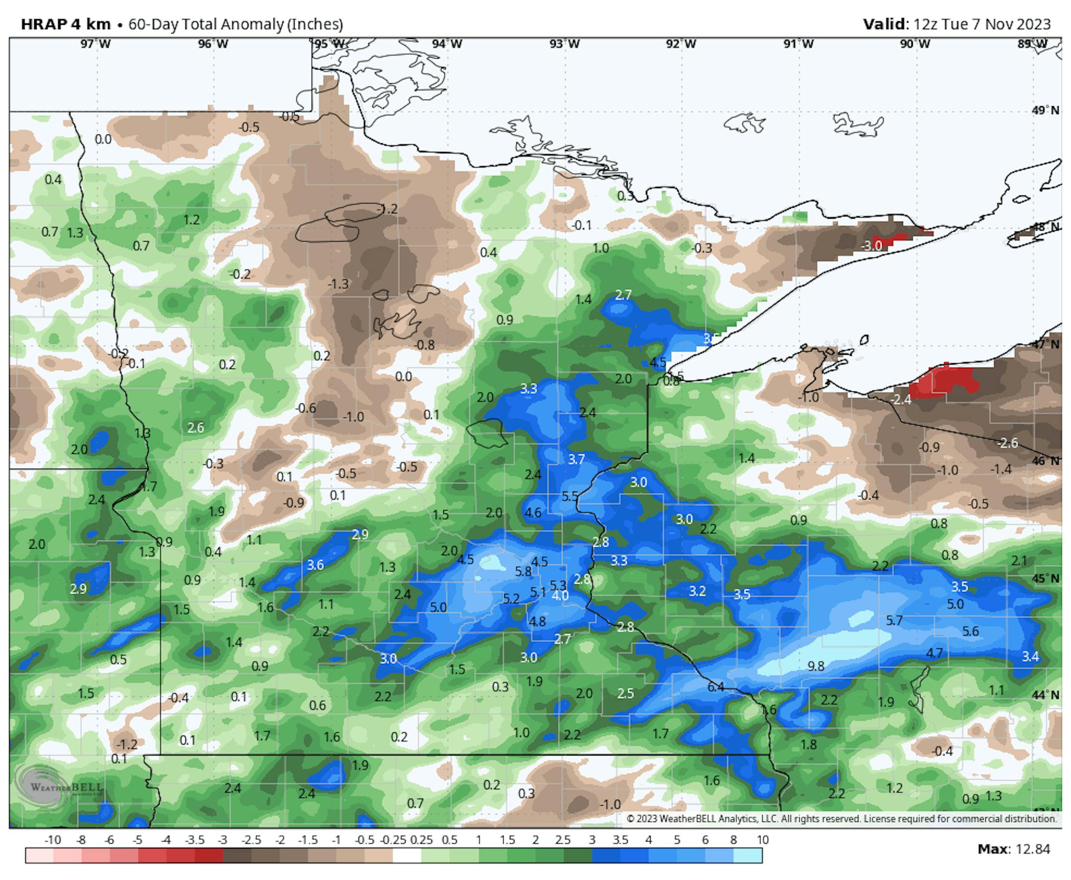
60 Day Precipitation Anomaly

Thanks to some recent heavy rains parts of the state are now in a surplus over the last 60 days. Some of the biggest surpluses are showing up in blue in pockets across parts of central Minnesota, including the Twin Cities and into western Wisconsin. It has been a very soggy last 7 weeks.

Drought Update

Recent heavy rains since late September have helped the drought situation quite a bit in across the state. With that being said, nearly 18% of the state is still in a severe drought, which has improved from 34% nearly 3 months ago.

Twin Cities Weather Outlook For Saturday

The weather outlook for the Twin Cities on Saturday, November 11th will be pretty close to average for this time of the year with readings warming into the mid 40s. Skies will be mostly cloudy with turning quite breezy into the afternoon.

Meteograms For Minneapolis

Temperatures in Minneapolis will start in the lower 30s in the morning and will warm into the low/mid 40s by the afternoon. Highs will be pretty close to average for this time of year under mostly cloudy skies.

Weather Outlook For Saturday

The weather outlook for Saturday will be pretty close to average for this time of the year with highs warming into the 30s across the northern part of the state and the 40s and 50s across the southern part of the state.

Extended Temperature Outlook For Minneapolis

The 5 day temperature outlook for Minneapolis shows mild temperatures returning later this weekend and into the week ahead with highs warming into the 50s and 60s, which will be nearly +10F to +20F above average for this time of the year.

Extended Weather Outlook For Minneapolis

The extended temperature outlook for Minneapolis shows another warm spell with highs warming into the 50s and 60s through much of the week ahead. We will also be mostly dry through the week ahead.

The Extended Outlook Calls For Warmer Temps

According to NOAA's National Blend of Models, temps will be quite a bit warmer than average as we continue through the middle part of the month. Readings could warm into the mid/upper 50s and low 60s, which will be well above average for that time of the year. Overnight lows could be in the 30s and 40s, which is above average for this time of the year.

Atlantic Hurricane Season Winding Down

The Atlantic hurricane season runs from June 1st to November 30th. November is typically a very quiet month, but there can still be storms. In fact, last year, Hurricane Nicole made landfall along the east coast of Florida.

Weather Outlook

Weather conditions across the Central US will be fairly quiet over the next several days with mostly dry weather in place through much of next week.

8 to 14 Day Temperature Outlook

According to NOAA's Climate Prediction Center, the 8 to 14 day temperature outlook shows Warmer than average temperatures across the eastern two-thirds of the nation, especially along and east of the Mississippi River.

8 to 14 Day Precipitation Outlook

The 8 to 14 Day Precipitation Outlook shows more active weather in place across more of the nation as we approach the middle part of the month and beyond.

October Stages A Comeback Next Week
By Paul Douglas

The tropical storm-force wind gusts have abated. I'm happy for little things. Thursday's winds peaked at 45 mph in the Twin Cities, and I saw a few low-visibility dust storms driving up to our cabin on Pelican Lake. Crazy.

Dr. Mark Seeley confirms November as the second windiest month of the year, second only to April. Seeley reports a 2.6F November temperature rise in the last century, statewide. Note to self: November also has the distinction of being the cloudiest month of the year. Any day the sun is out is kind of a big deal.

A passing shower or sprinkle is possible today, but a rare sunshine sighting is expected Sunday, with an unusual number of sunny days next week as temperatures surge into the 50s. A few days of 60-degree readings are possible by midweek, especially south and west of the Twin Cities; roughly 15-20F above average.

We cool off Friday and cold fronts are as inevitable as stupid takes on social media, but I don't see anything arctic through Thanksgiving. After that, all bets are off.

Extended Forecast

SATURDAY: Cloudy, stray shower. Winds: SE 10-20. High 44.

SATURDAY NIGHT: Mostly cloudy. Winds: SSE 10-15. Low: 40.

SUNDAY: Partly sunny and pleasant. Winds: SW 10-20. High: 56.

MONDAY: Blue sky. Too nice to rake leaves. Winds: S 8-13. Wake-up: 39. High: 55.

TUESDAY: Early October? Sunny and breezy. Winds: S 10-25. Wake-up: 44. High: 60.

WEDNESDAY: Plenty of sun, less wind. Winds: SE 5-10. Wake-up: 46. High 59.

THURSDAY: Still mild. Winds pick up. Winds: W 15-30. Wake-up: 48. High 62.

FRIDAY: Mostly cloudy and cooler. Winds: SW 10-20. Wake-up: 34. High 47.

This Day in Weather History

November 11th

1940: The Great Armistice Day Blizzard kills 49 people in Minnesota. Food dropped by Pilot Max Conrad saved stranded hunters. The barometer fell to 28.66 inches at Duluth. Some roads were so badly blocked with snow they weren't opened until Nov. 22.

Average High/Low for Minneapolis

November 11th

Average High: 44F (Record: 64F set in 2005)

Average Low: 30F (Record: -1F set in 1986)

Record Rainfall: 2.52" set in 1940

Record Snowfall: 8.2" set in 1940

Sunrise/Sunset Times for Minneapolis

November 11th

Sunrise: 7:04am

Sunset: 4:49pm

Hours of Daylight: ~9 hours & 44 minutes

Daylight LOST since yesterday: 2 Minutes & 31 Seconds

Daylight LOST since Summer Solstice (June 21st): ~ 6 Hour & 3 Minutes

Moon Phase for November 11th at Midnight

1.1 Days Before Last Quarter

National High Temps on Saturday

The weather outlook across the Central US shows much cooler weather in place across the eastern half of the nation with temp running below average for this time of the year.

National Weather Outlook For Saturday

The National Weather Outlook on Saturday shows areas heavy rain continuing across the Gulf Coast States through the weekend and into early next week. Meanwhile, the Central US should remain dry and quiet.

National Weather Outlook

The National Weather outlook through Sunday shows areas of heavy rain continuing in the Deep South with areas of heavy rain possible. Meanwhile, much of the rest of the nation will be quiet.

Extended Precipitation Outlook

The extended precipitation outlook shows areas of heavier rain across the Southern US and decent precipitation along the West Coast. However, much of the Central and High Plains and Midwest will be fairly dry.

Extended Snowfall Outlook

According to the ECMWF weather model, areas of snow will be found across the high elevations in the Western US. There will also be some decent snowfall along the international border and just north into Canada.

Climate Stories

"Shenandoah Closes Trails, Bans Campfires as Wildfire Spreads in National Park"

"National Park Service encourages hikers to avoid Whiteoak Canyon and Old Rag due to poor air quality. Shenandoah National Park officials closed two trails on Saturday after the Quaker Run Fire breached a containment line and entered the park. The entire Wilhite Wagon Trail and the Graves Mill Trail from Staunton River Trail to the Rapidan Fire Road are closed until further notice. The Quaker Run Fire ignited on October 26, just outside of the park boundary. It began as a 20-acre brush fire but slowly grew to a size of about 2,800 acres. As of Monday, 670 acres of the park were engulfed by flames. Although the fire has been slow to grow, high wind and drought conditions have made it difficult to contain. Kevin Dawson, a spokesman with Virginia's Department of Forestry told the Daily Progress: "When we originally started with this, we were hoping to keep this as small as possible, but the terrain on the side of the mountains, the steep terrain and the amount of rock, made it difficult for our crews to reach it." He added: "The perimeter has gotten larger because of that."

See more from Outside HERE:

"Aurora Could Glow Over U.S. This Weekend After Earth-Strike Zone Event"

"The northern lights—also called the aurora borealis—could be visible in northern U.S. states after a spike in magnetic activity on the sun on Thursday, November 9. It comes after a correctly predicted stunning display last Sunday when a strong geomagnetic storm produced aurora in the night skies for northern U.S. states and Europe. Aurora was glimpsed as far south as Greece and Italy. According to SpaceWeather.com, the incoming geomagnetic storm won't be as strong as last weekend's G3-class event, but it could still produce G2 activity levels. That could be enough to make aurora visible in northern U.S. states from New York to Washington, said the website. It could also mean a second scientific rocket launch by NASA in Alaska."

See more from Forbes HERE:

Where is the best place to see the April 2024 total solar eclipse?

"Witnessing a total solar eclipse is a rare opportunity — after next year's event, on April 8, 2024, the next chance to see a total solar eclipse in North America won't occur for more than 20 years. Naturally, being in the right place at the right time is crucial. So where's the best place to see the April 2024 total solar eclipse? First, you'll have to be within the narrow path of totality to see a full total solar eclipse, in which the moon completely covers the sun's face from our point of view on Earth. This path is just 115 miles (185 kilometers) wide, and on land, it stretches over 4,000 miles (6,400 km) from Mazatlán in western Mexico to South Bird Island in Newfoundland, Canada. Totality will first be visible in Mexico, where Sinaloa, Durango, Chihuahua and Coahuila will go under the moon's central shadow. It will then cross parts of 15 U.S. states: Texas, Oklahoma, Arkansas, Missouri, Illinois, Kentucky, Tennessee, Michigan, Indiana, Ohio, Pennsylvania, New York, Vermont, New Hampshire and Maine. Parts of the Canadian provinces Ontario, Quebec, New Brunswick, Prince Edward Island, Nova Scotia and Newfoundland will also experience totality."

See more from Space.com HERE:

Thanks for checking in and don't forget to follow me on Twitter @TNelsonWX