30 Day Precipitation

Here's a look at rainfall over the last 30 days, which shows quite a bit around the Twin Cities and surrounding areas. Since September 23rd, the Twin Cities has picked up nearly 7.50" !! There are even heavier amounts north and west of the metro, where some double-digit tallies have fallen.

90 Day Precipitation Anomaly

Thanks to some recent heavy rains parts of the state are now in a surplus over the last 90 days. Some of the biggest surpluses are showing up in blue in pockets across parts of central Minnesota, including the Twin Cities and into western Wisconsin. It has been a very soggy last 3 weeks.

Drought Update

Recent heavy rains have helped the drought situation quite a bit in spots across the state. With that being said, we're still in a drought across much of the state with nearly 5% under an extreme drought, which improved since last week. We should see additional improvement after this weeks rain, but we won't see that show up in the drought maps until next week. Stay tuned...

Extended Precipitation Anomaly

Here's the extended precipitation outlook through early next week, which shows a few pockets of 0.25" to 0.50" amounts across the northern part of the state.

Fall Color Update

Here's a picture from Horizon Adventure Drone Services and the MN DNR website at Lake Carlos State Park . Fall colors look well underway there and will continue over the coming days.
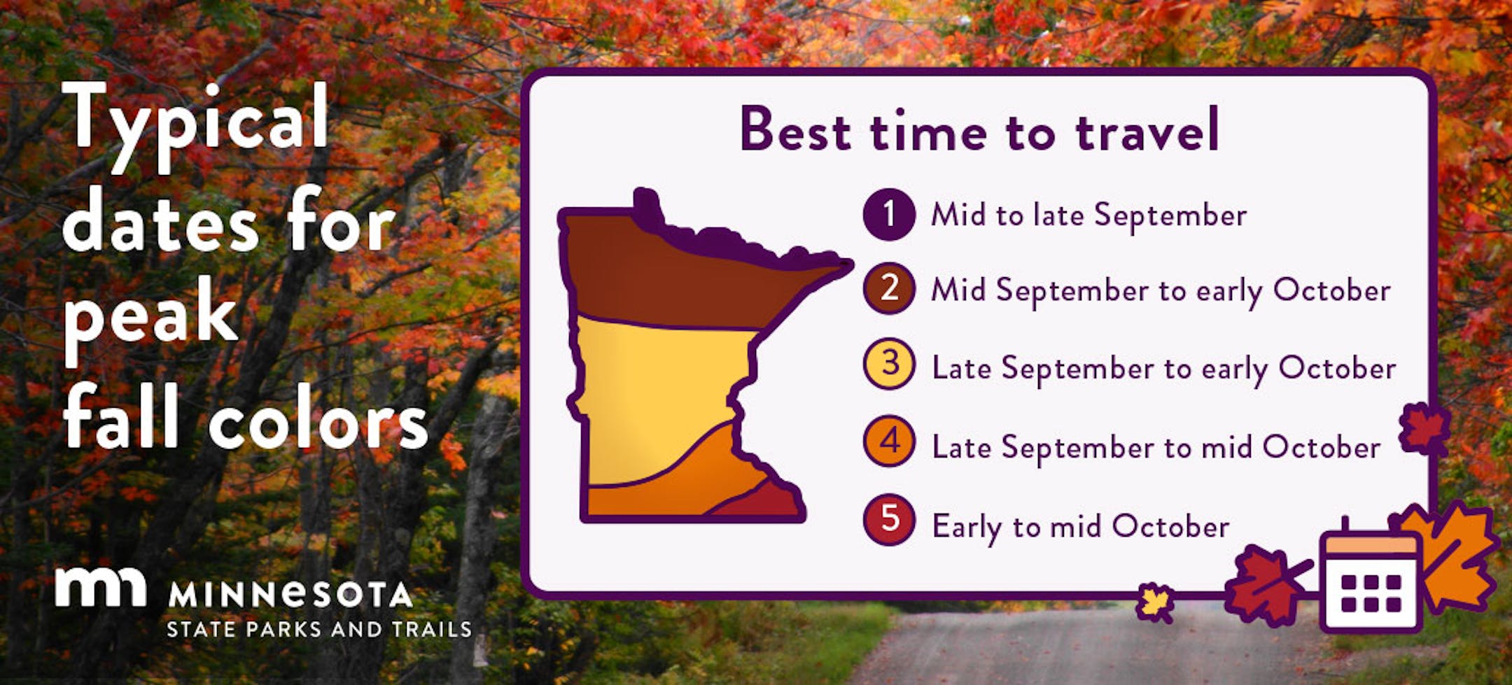
Fall Color Update

According to the MN DNR, the fall color season is well underway. Parts of northern Minnesota are already at and past peak color. Fall colors will continue to rapidly change, so take a moment and enjoy the season while you can. Note that most leaves will vacate the premises in a few weeks and won't return until sometime in mid/late May...

See more from the MN DNR HERE:

Wisconsin Fall Color Update

Here's a look at the fall color report in Wisconsin. Fall colors are peaking in some areas and peak isn't far away in others.

See more from Travel Wisconsin HERE:

Typical Peak Fall Color

According to the MN DNR, typical peak color arrives across the international border mid to late September with peak color arriving near the Twin Cities late September to mid October. It won't be long now and you'll be able to find your favorite fall color in a backyard near you.

7 Day Atlantic Outlook

The 7 day outlook for the Atlantic Basin shows a potential tropical wave in the Central Atlantic that had a decent chance of tropical development over the next couple of days. This system will continue to drift northwest, but hopefully will steer north of the Caribbean islands, stay tuned..

Past Peak of the Atlantic Hurricane Season

The Atlantic hurricane season runs from June 1st to November 30th, but did you know that the typical peak is September 10th? This is when the Atlantic Basin has had the most hurricanes and named storms since records began. This is also when weather conditions are at optimal levels for these types of storms.

Weather Outlook For Tuesday

The weather outlook on Tuesday will warm into the 50s and 60s across the state, which will be nearly +5F to +10F above average for this time of the year. We'll see partly cloudy skies through the day as well.

Twin Cities Weather Outlook For Tuesday

The weather outlook for the Twin Cities on Tuesday, October 16th will be pretty spectacular for mid October. Temp will be nearly +5F above average for this time of the year with partly cloudy skies and light winds. Enjoy.

Meteograms For Minneapolis

Temperature in Minneapolis will start in the low 40s in the morning and will warm into the low 60s in the afternoon. It'll be partly cloudy with south to southwesterly winds around 10mph to 15mph.

Extended Temperature Outlook For Minneapolis

The 5 day temperature outlook for Minneapolis shows fairly mild weather in place through midweek with temperatures running nearly +5F above average for mid October. We'll cool down during the 2nd half of the week to more normal levels.

Extended Weather Outlook For Minneapolis

The last couple of days have been quite nice around the region, but we'll see a little rain and wind on Wednesday with cooler temps by the end of the week and weekend ahead. Temps will drop into the mid 50s by the weekend, which will be a little cooler than average for this time of the year.

Feeling Like Fall

According to NOAA's National Blend of Models, temps will hover in the 50s and 60s over the next several days, which will be within range of average for this time of the year. I don't see any major heat waves or cold snaps coming quite yet.

Weather Outlook

Weather conditions in the Midwest will still be quiet on Tuesday, but a clipper system will move in on Wednesday with areas of wind and light rain. We could see a little more light rain late week, but the overall trend looks dry with shots of light rain here and there. Nothing like what we had last Friday.

8 to 14 Day Temperature Outlook

According to NOAA's Climate Prediction Center, the 8 to 14 day temperature outlook shows warmer than average temperatures across the eastern half of the country, while cooler than average temps will be in place across the western half of the country.

8 to 14 Day Precipitation Outlook

As we approach the end of October, things look a little more unsettled across the central and western half the nation, which could include the Midwest.

El Nino May Give Winter A Milder Nudge
By Paul Douglas

The upcoming winter is an enigma wrapped in a riddle. It will get cold. It will snow. Beyond that the details become hopelessly murky. Obligatory disclaimers aside, there are clues about the severity of the winter to come.

Scientists are tracking a major El Nino warming event in the Pacific Ocean, which may "nudge" Minnesota's weather in a particular direction. During El Nino winters the jet stream, the main super-highway for storms, often whisks big storms well south of Minnesota. There are notable exceptions, but statistically, odds favor a milder and drier winter, looking at previous El Nino events. According to the MN State Climate Office the El Ninos of 1982-83 and 1997-98 were among the 6 warmest on record for MSP. We shall see.

60 degrees will feel good today with ample sunshine, before a Wednesday storm pushes showers across the state. Expect 1 or 2 tenths of an inch of rain; maybe a few half-inch amounts over central Minnesota.

I see a few 60-degree highs extending deep into October this year.

Extended Forecast

TUESDAY: Partly sunny, pleasant. Winds: S 8-13. High: 61.

TUESDAY NIGHT: Mostly cloudy Winds: S 8-13. Low: 50.

WEDNESDAY: Umbrella weather. Showers likely. Winds: SW 10-15. High 59.

THURSDAY: Mostly cloudy and breezy. Winds: NW 10-20. Wake-up: 49. High 58.

FRIDAY: Blue sky, a milder breeze. Winds: S 10-20. Wake-up: 39. High 64.

SATURDAY: Mostly cloudy, a stiff wind. Winds: NW 15-30. Wake-up: 49. High 57.

SUNDAY: Plenty of sunshine, leaves need raking. Winds: N 10-15. Wake-up: 42. High: 55.

MONDAY: Breezy with sunshine. Winds: SE 10-20. Wake-up: 38. High: 60.

This Day in Weather History

October 17th

1971: Heavy rain falls in NW Minnesota. 4.02 inches is recorded at Georgetown (20 miles N of Moorhead).

1952: Record lows between 10 to 15 degrees are reported across central Minnesota, including a low of 10 at St. Cloud, 12 at Glenwood, and 14 at Alexandria, Litchfield, and Mora.

Average High/Low for Minneapolis

October 17th

Average High: 58F (Record: 84F set in 1910)

Average Low: 40F (Record: 22F set in 1948 & 1952)

Record Rainfall: 1.24" set in 1879

Record Snowfall: Trace set in 1933, 1990 & 2004

Sunrise/Sunset Times for Minneapolis

October 17th

Sunrise: 7:31am

Sunset: 6:25pm

Hours of Daylight: ~10 hours & 54 minutes

Daylight LOST since yesterday: 3 Minutes & 1 Seconds

Daylight LOST since Summer Solstice (June 21st): ~ 4 Hour & 53 Minutes

Moon Phase for October 17th at Midnight

3.5 Days Since New Moon

See more from Space.com HERE:

National High Temps on Tuesday

Temps on Tuesday will be cooler than average by nearly -5F to -10F across the Southeastern US. Meanwhile, Folks along the Front Range of the Rockies and the Intermountain-West will be warmer than average by quite a margin.

National Weather Outlook For Tuesday

Much of the nation will be quite on Tuesday with the exception of the High Plains as a quick clipper system moves through. Areas of light rain and wind will move through during the midweek time frame.

National Weather Outlook

The National Weather outlook through Thursday shows fairly quiet conditions across much of the nation. There is a clipper-system moving through the Midwest around midweek with areas of rain and wind, but it will be short-lived.

Extended Precipitation Outlook

The extended precipitation outlook through the weekend shows areas of heavy rainfall across parts of the Northeast US. Meanwhile, much of the Plains will stay dry.

Climate Stories

"Rising temperatures threaten the Mediterranean's tourism industry"

"Tourism generates around $635 billion per year in the European Union. But there are concerns that the increasing impact of climate change is affecting the tourism industry, particularly in some of the Mediterranean countries. Temperatures are increasing in the Mediterranean 20% faster than the global average. Last summer, Spain had four heat waves, during which temperatures exceeded 40º Celsius, or 104º Fahrenheit, in many parts of the country. Such conditions are likely to have an impact on tourism. By the swimming pool of the Belroy Hotel in Benidorm, the hotel's owner and president of the local hotel association, Federico Fuster, said he has noticed the change in the climate here. "We used to have way smoother nights. The temperature used to go down a little bit and we have a little rest at night, right?" he said. "But this summer for 20, 25 days, that didn't happen." Fuster is worried about the climate crisis. But he does see a possible upside for the tourism industry in the way that seasonal behavior is changing."

See more from Market Place HERE:

"NASA: We'd Have 30 Minutes' Warning Before a Killer Solar Storm Hits Earth"

"We've touched on the hazards of solar storms plenty of times in the past. We've also recently started reporting even more stories involving some sort of AI, especially in the last few months since it has come back to the forefront of many discussions around technologies. So it should come as no surprise that a team at NASA has been busily applying AI models to solar storm data to develop an early warning system that they think could give the planet about 30 minutes' notice before a potentially devastating solar storm hits a particular area. That lead time is thanks to the fact that light (i.e., what radio signals are made out of) can travel faster than the solar material ejected out of the Sun in the event of these solar storms. In some events, such as one that impacted Quebec around 35 years ago, they can shut off power for hours. More extreme events, such as the Carrington event that happened more than 150 years ago, can cause massive destruction of electrical and communication infrastructure if they were to happen today."

See more from Science Alert HERE:

"FAA WARNS THAT FALLING SATELLITES ARE GOING TO START KILLING PEOPLE"

"The Federal Aviation Administration has sounded the alarm on the danger of falling Starlink satellites, and SpaceX is not happy. SpaceX's satellites, which are stationed in low-Earth orbit, are intended to only last five years before de-orbiting. Their expendable nature has an upside, though: they're also designed to be "demisable," or to burn up completely in the atmosphere during re-entry, posing little if any risk to those of us on the ground. But the FAA begs to differ. In a report to Congress made public last week, the agency claims that by 2035, some 28,000 fragments from Starlink satellites falling back to Earth could survive re-entry each year. That has unsettling implications. With so much debris, the report concludes, the chance of a stray satellite fragment hitting and killing someone on the ground will rise to 61 percent each year."

See more from EarthSky HERE:

Thanks for checking in and don't forget to follow me on Twitter @TNelsonWX