Fall Color Update

Look at the beautiful fall colors spotted on the Lutsen Mountain webcam on Wednesday! You can see a lot of the forecast has at least started to turn - with some trees reaching their peak.

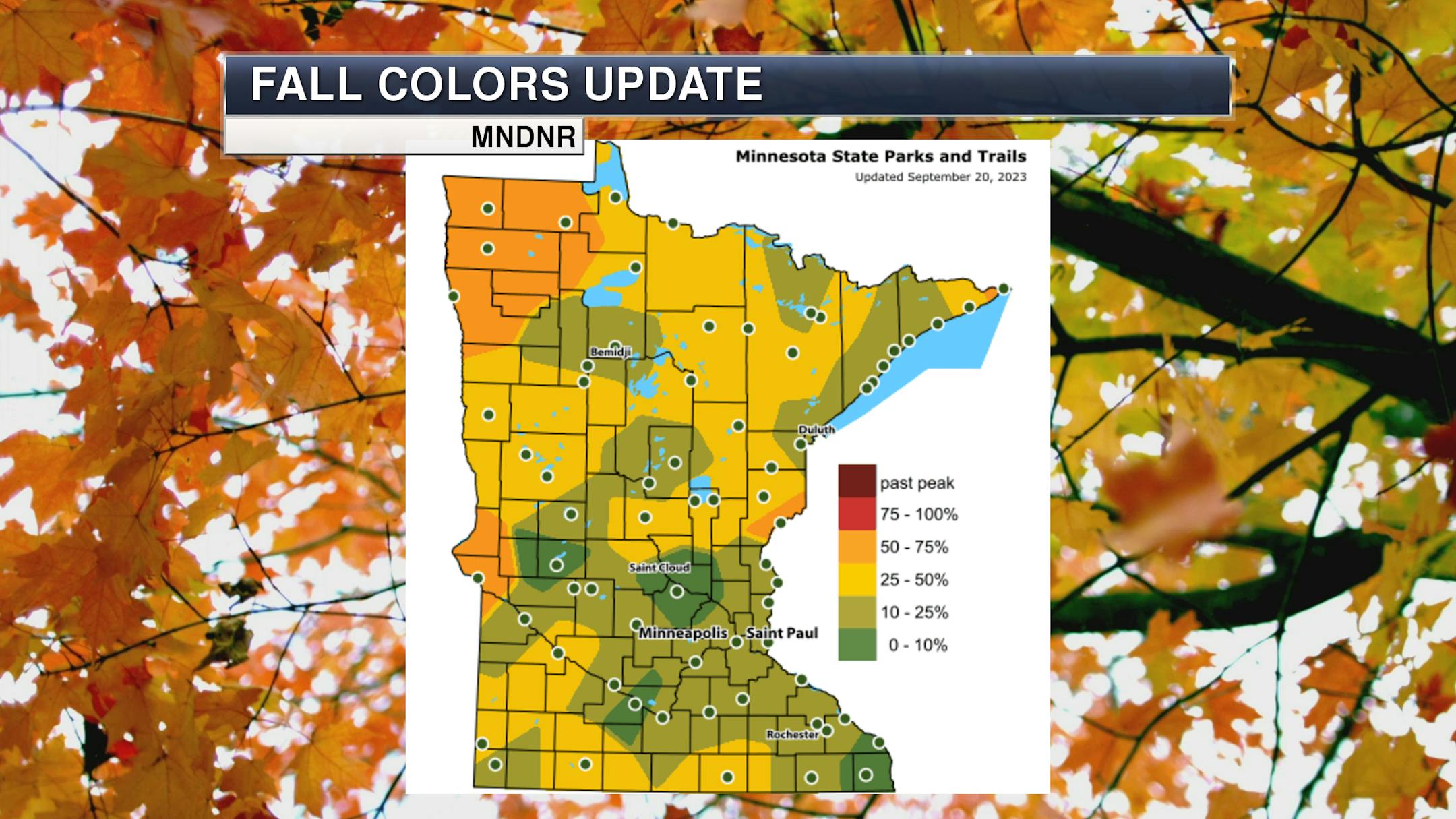
Over the past few days, fall colors have started to expand across the state. We're now seeing parts of northwestern, western, and northeastern Minnesota at 50-75% color according to the Minnesota DNR Fall Color Finder. Old Mill State Park noted in their Wednesday update: "The colors of fall can be seen throughout the park. A few flowers can be spotted along the river. The grasses have changed from their summer green into a more fall look, and the trees in the park have made the decision to show their fall colors."

_______________________________________________

Northwestern Minnesota Air Quality Alert

Meanwhile, we're tracking some wildfire smoke once again impacts parts of the state - this time, mainly impacting northwestern and north-central Minnesota through Thursday. An Air Quality Alert is in place including Bemidji, Roseau, East Grand Forks, Moorhead, and International Falls through 11 PM Thursday.

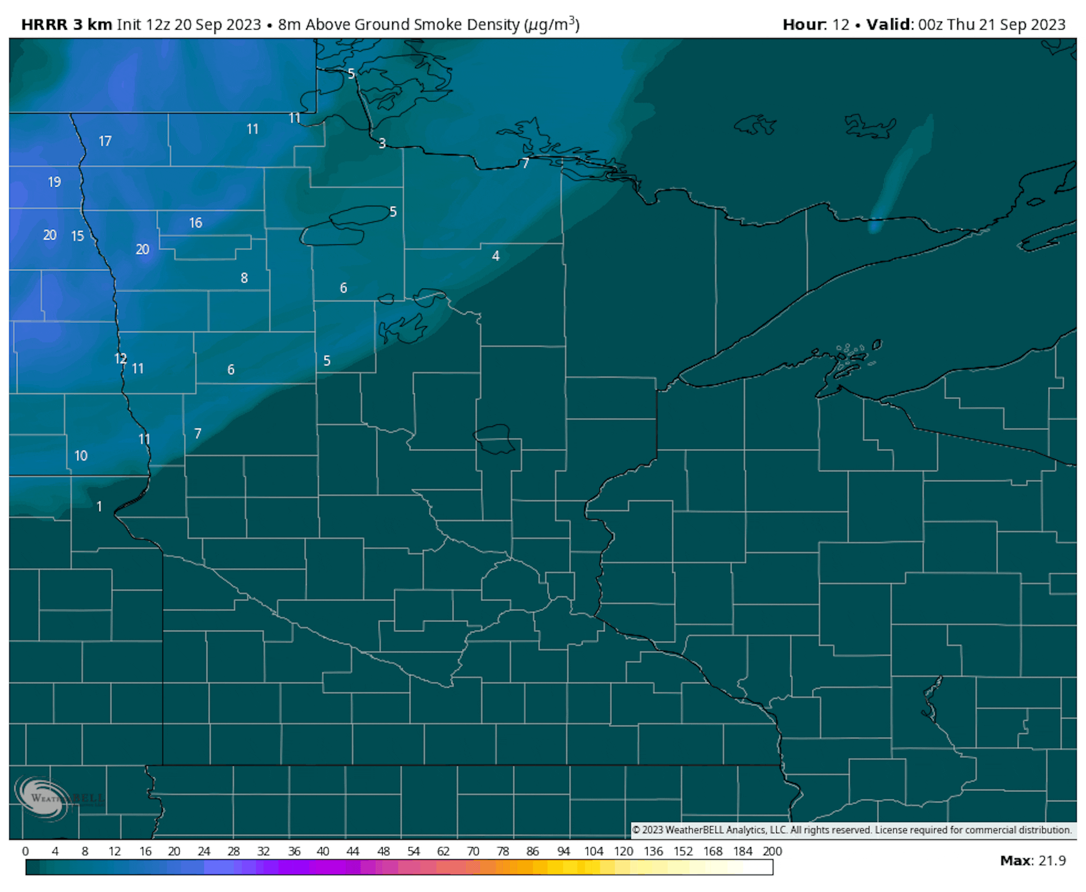
Forecast near-smoke from 7 PM Wednesday to 7 PM Thursday.

The forecast loop of near-surface smoke shows it mainly hanging in northwestern Minnesota - though expanding a little into north-central Minnesota into Thursday. The greatest concentration will mainly be west of the Red Lakes.

_______________________________________________

Warm, Sunny Thursday - Storms Possible In Northern/Western Minnesota

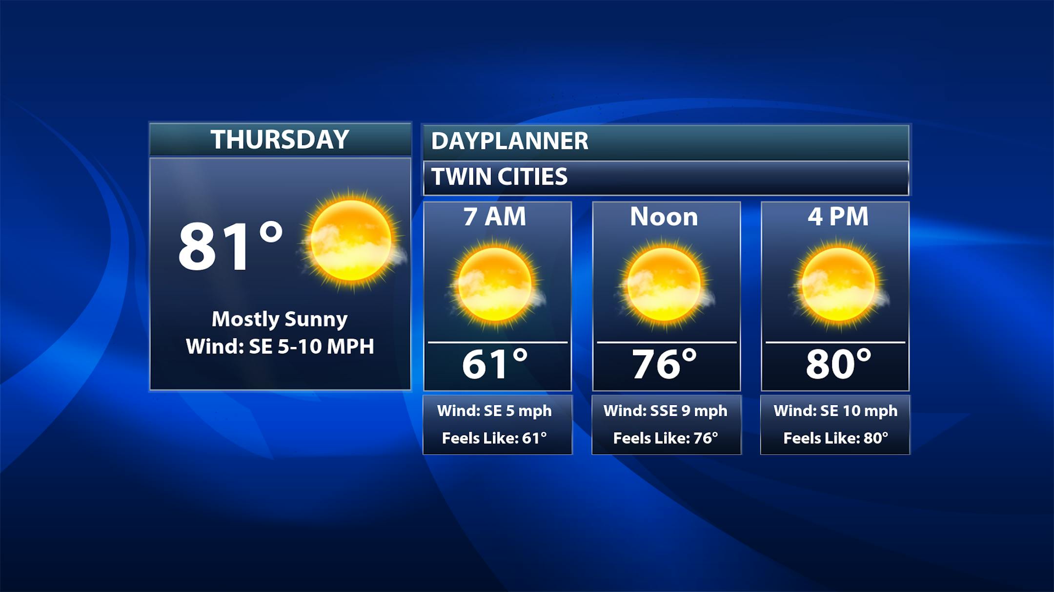
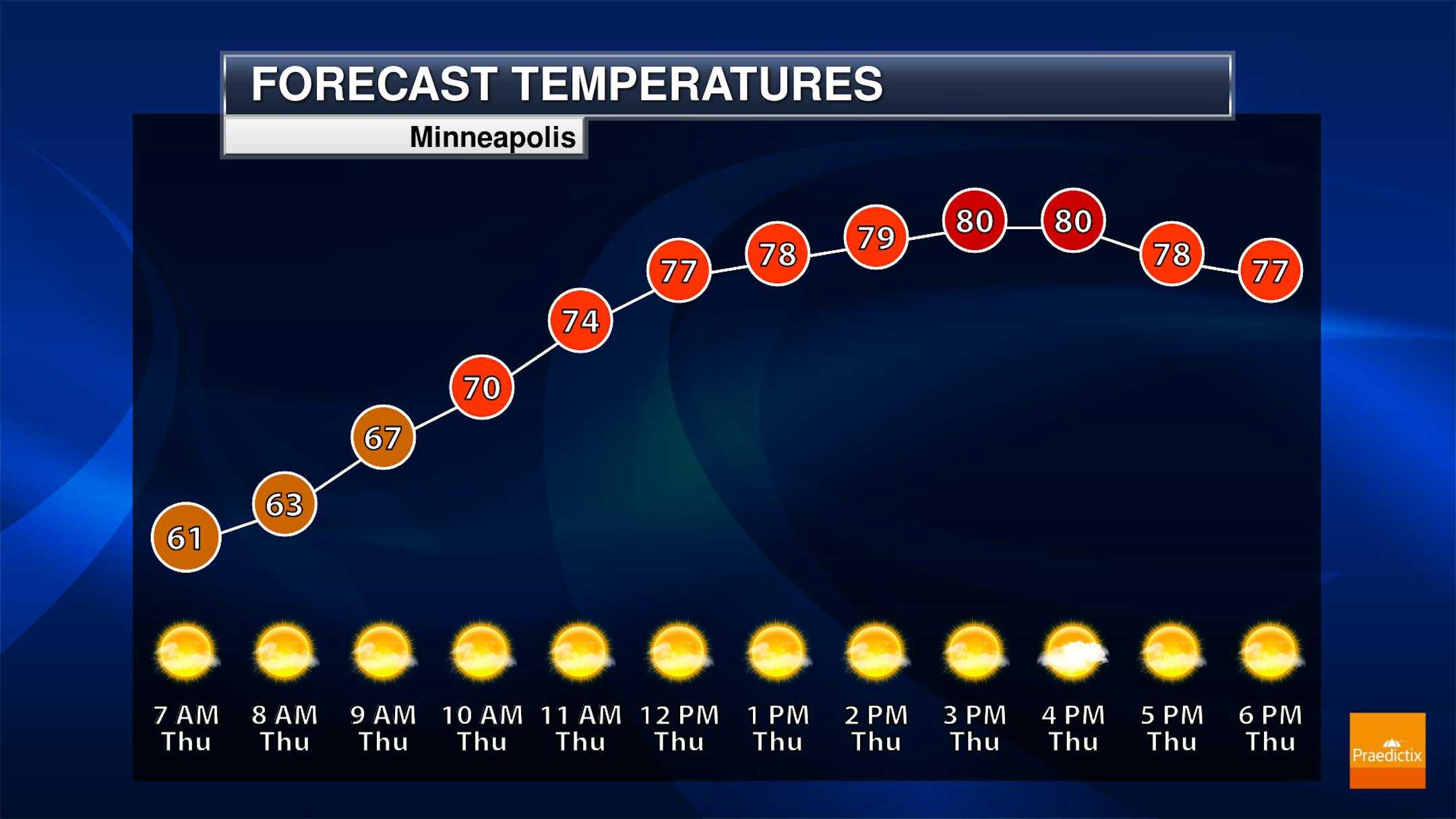
A quiet and warm September Thursday awaits us here in the metro, with lots of sunshine and highs in the low 80s. This is not near a record, though - that's 94F from 1937.

The highest chance of seeing showers or storms on Thursday will be in northern and western Minnesota. Elsewhere, mainly sunny skies are expected. Highs range from around 70F along the North Shore and Roseau area to the low 80s in central and southern Minnesota.

_______________________________________________

Storm Chances Move In This Weekend

Friday: Most of the day should be dry in the metro, but some slight rain chances are possible late and into the overnight hours. Highs climb into the upper 70s.

Saturday and Sunday: We will watch scattered showers and storms around this weekend. I think the best chance of rain in the metro this weekend will be Saturday Night into Sunday. Highs make it to the mid-70s on Saturday but may not make it out of the 60s on Sunday.

Forecast loop from 7 PM Friday to 7 AM Tuesday.

We will be watching rounds of rain across the region later this week through early next week as we watch a few different waves and one slow-moving system moving across the upper Midwest. Rounds of rain - heavy at times - can be expected.

The heaviest rain through the middle of next week will be across portions of southwestern Minnesota, where rainfall amounts of over 2" will be possible. Rainfall totals fall the farther northeast you head.

_______________________________________________

Weekend Showers and T-storms Still Likely
By Paul Douglas

Storms, given a choice, PREFER to come on weekends. And major holidays. And the Minnesota Fishing Opener. Mother Nature has a wicked sense of humor.

Have a Plan B (indoors) for at least part of the upcoming weekend, because a slow-moving storm will spark a few rounds of showers and T-storms. Probably not the soaking we need, but half of inch of rain is likely for most towns, with an inch possible south and west of the Twin Cities.

With any luck the transition to winter will whip up a series of big, wet storms into November, soaking topsoil before the ground freezes by Thanksgiving. But that is not assured, and during El Nino winters like the one we're sliding into, we tend to get less snow, ice and rain. Water levels on many area lakes are comparable to last year at this time, when the drought was even worse.

In the meantime sublime weather hangs on today and Friday with daytime highs topping 80F. Fall allegedly arrives Saturday, but models suggest more 70s, even a shot at 80 into early October. Wow.

_______________________________________________

Paul's Extended Twin Cities Forecast

THURSDAY: Lukewarm sunshine. Wake up 61. High 82. Chance of precipitation 0%. Wind SE 10-15 mph.

FRIDAY: Mix of clouds and sun, still nice. Wake up 61. High 80. Chance of precipitation 10%. Wind SE 10-20 mph.

SATURDAY: Showers and T-storms arrive. Wake up 60. High 75. Chance of precipitation 80%. Wind SE 15-25 mph.

SUNDAY: Morning puddles, some PM sun? Wake up 60. High 79. Chance of precipitation 70%. Wind SE 10-20 mph.

MONDAY: Spurts of sun, few showers up north. Wake up 59. High 78. Chance of precipitation 30%. Wind E 10-20 mph.

TUESDAY: Unsettled, showers in the area. Wake up 58. High 75. Chance of precipitation 60%. Wind NE 10-20 mph.

WEDNESDAY: Drier, more clouds than sun. Wake up 59. High 76. Chance of precipitation 20%. Wind NE 8-13 mph.

_______________________________________________

Minneapolis Weather Almanac And Sun Data
September 21st

*Length Of Day: 12 hours, 13 minutes, and 57 seconds
*Daylight LOST Since Yesterday: 3 minutes and 6 seconds

*When Do We Drop Below 12 Hours Of Sunlight? September 26th (11 hours, 58 minutes, 25 seconds)
*When Are Sunrises At/After 7:00 AM? September 23rd (7:01 AM)
*When Are Sunsets At/Before 7:00 PM? September 28th (6:59 PM)
_______________________________________________

This Day in Weather History
September 21st

2005: An unusually intense late season severe weather event affects parts of central Minnesota and west central Wisconsin during the late afternoon and evening hours. Baseball-sized hail, damaging thunderstorm winds, and tornadoes result from several supercell thunderstorms. The most widespread damage occurs across the northern and eastern portions of the Twin Cities. Three tornadoes rake across parts of Anoka and northern Hennepin counties, including an F2, but the tornado damage is overshadowed by the widespread extreme wind damage associated with the rear flank downdraft of the supercell. In addition to the severe weather, many locations received substantial amounts of rain. Many streets and underpasses in the northern Twin Cities metro area were flooded Wednesday night, where radar precipitation estimates were in excess of 3 inches.

1994: 1/2 inch hail in Blue Earth County results in $6 million in crop damages.

1924: Very strong winds occur in Duluth, with a peak gust of 64 mph.

_______________________________________________

National Weather Forecast

On Thursday, we'll be tracking a system in the central United States producing showers and thunderstorms. Some snow will mix in back in the western United States. Meanwhile, a frontal boundary across Florida will produce storms as well.

The heaviest rain through the end of the week will be in parts of eastern Oklahoma and western Arkansas, where 3-5" of rain could cause flash flooding.

_______________________________________________

Great River Greening gets $10 million for trees to cool urban heat islands in Minnesota

More from the Star Tribune: "Thousands of new trees will soon take root in cities across Minnesota thanks to a $10 million federal grant received by the St. Paul-based nonprofit Great River Greening. The trees will help cool identified urban heat islands in Faribault, Owatonna, Brooklyn Center, St. Cloud and St. Paul — areas where a lack of tree canopy and heat bouncing off concrete exacerbate the broil of climate change and create potentially deadly conditions. The $10 million award will finance the planting of nearly 14,000 trees over the next five years under a new project called Cooling Minnesota Communities. Planting will start in the spring, said Great River Greening Executive Director Kateri Routh."

State, federal funding fuels expansion of Minnesota microgrid research center

More from Energy News Network: "A St. Paul, Minnesota, college's microgrid research center is preparing to expand after securing significant new state and federal funding. The University of St. Thomas' Center for Microgrid Research plans to triple its three-person staff and enroll more students thanks to money from a $7.5 million state legislative appropriation and $11 million in federal defense bill earmarks secured by U.S. Rep. Betty McCollum. State officials who championed the funding said they hope the center's education and research efforts can help train future grid technicians and smooth the state's path to 100% clean electricity by 2040. "We're at a time of not only a great transition but of a great opportunity," said state Sen. Nick Frentz, a Democrat from Mankato. "We'll be looking at transmission, distributed generation and innovation as we transition, and funding for the St. Thomas microgrid research is a part of the state's plan to lead.""

Climate risks place 39 million U.S. homes at risk of losing their insurance

More from Grist: "From California to Florida, homeowners have been facing a new climate reality: Insurance companies don't want to cover their properties. According to a report released today, the problem will only get worse. The nonprofit climate research firm First Street Foundation found that, while about 6.8 million properties nationwide already rely on expensive public insurance programs, that's only a fraction of 39 million across the country that face similar conditions. "There's this climate insurance bubble out there," said Jeremy Porter, the head of climate implications at First Street and a contributor to the report. "And you can quantify it." Each state regulates its insurance market, and some limit how much companies can raise rates in a given year. In California, for example, anything more than a 7 percent hike requires a public hearing. According to First Street, such policies have meant premiums don't always accurately reflect risk, especially as climate change exacerbates natural disasters."

_______________________________________________

Follow me on:

Thanks for checking in and have a great day!

- D.J. Kayser