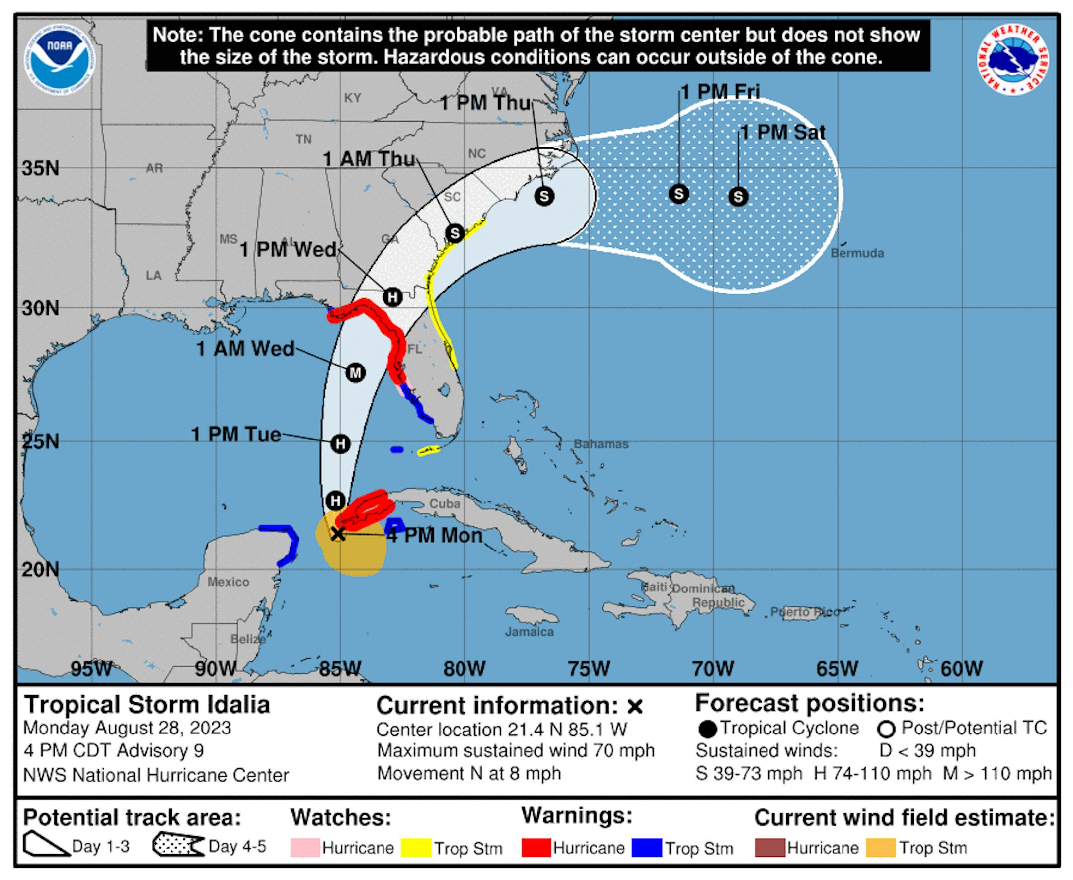
Tracking Idalia in the Gulf of Mexico

The National Hurricane Center starting issuing advisories for Tropical Depression TEN midday Saturday. By Monday, Tropical Storm Idalia had developed and is expected to continue to strengthen before making landfall along the Florida coastline as a possible major hurricane around midweek.

Tracking the Tropics

This system is expected to drift north into the Gulf of Mexico, while intensifying into a major hurricane before making landfall somewhere in the Big Bend area of Florida, where Hurricane Warnings has been issued. Tropical Storm Watches have been posted along the east coast of Florida, Georgia and South Carolina

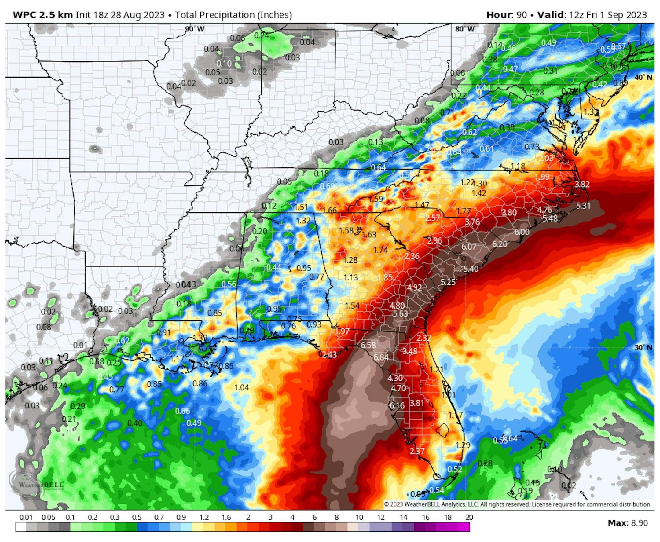
Heavy Rainfall Ahead

Regardless of how strong this storm gets, heavy rain will be one of the main concerns here. Widespread 3" to 6" of rainfall be possible from Florida through the Mid-Atlantic States with some spots possibly seeing as much as 6" to 10", which could could cause flooding.

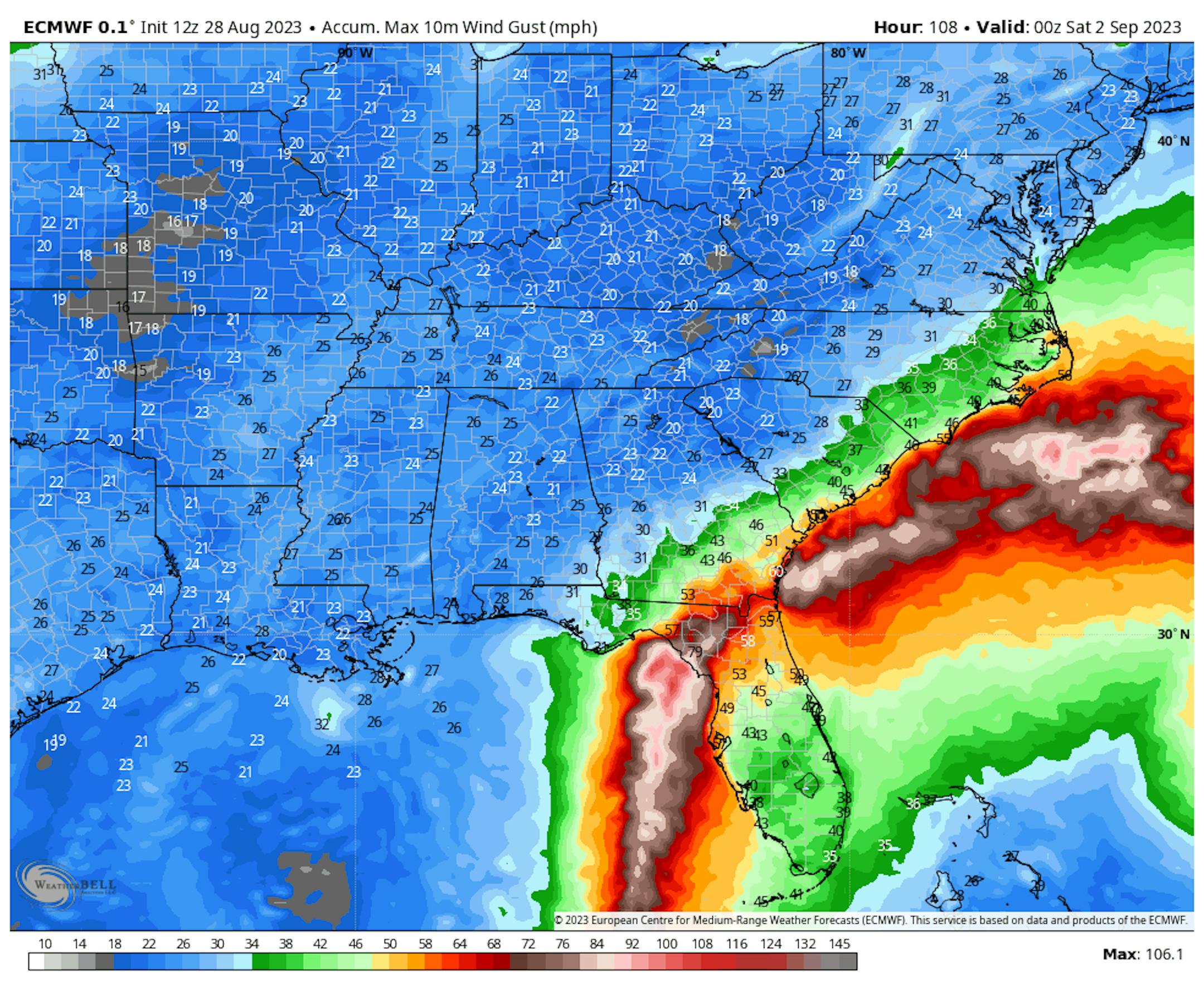
Gusty Winds Expected

Idalia is expected to reach the Florida coastline as a major hurricane with winds of nearly 120mph. This could certainly cause major damage and widespread power outages along with life-threatening storm surges.

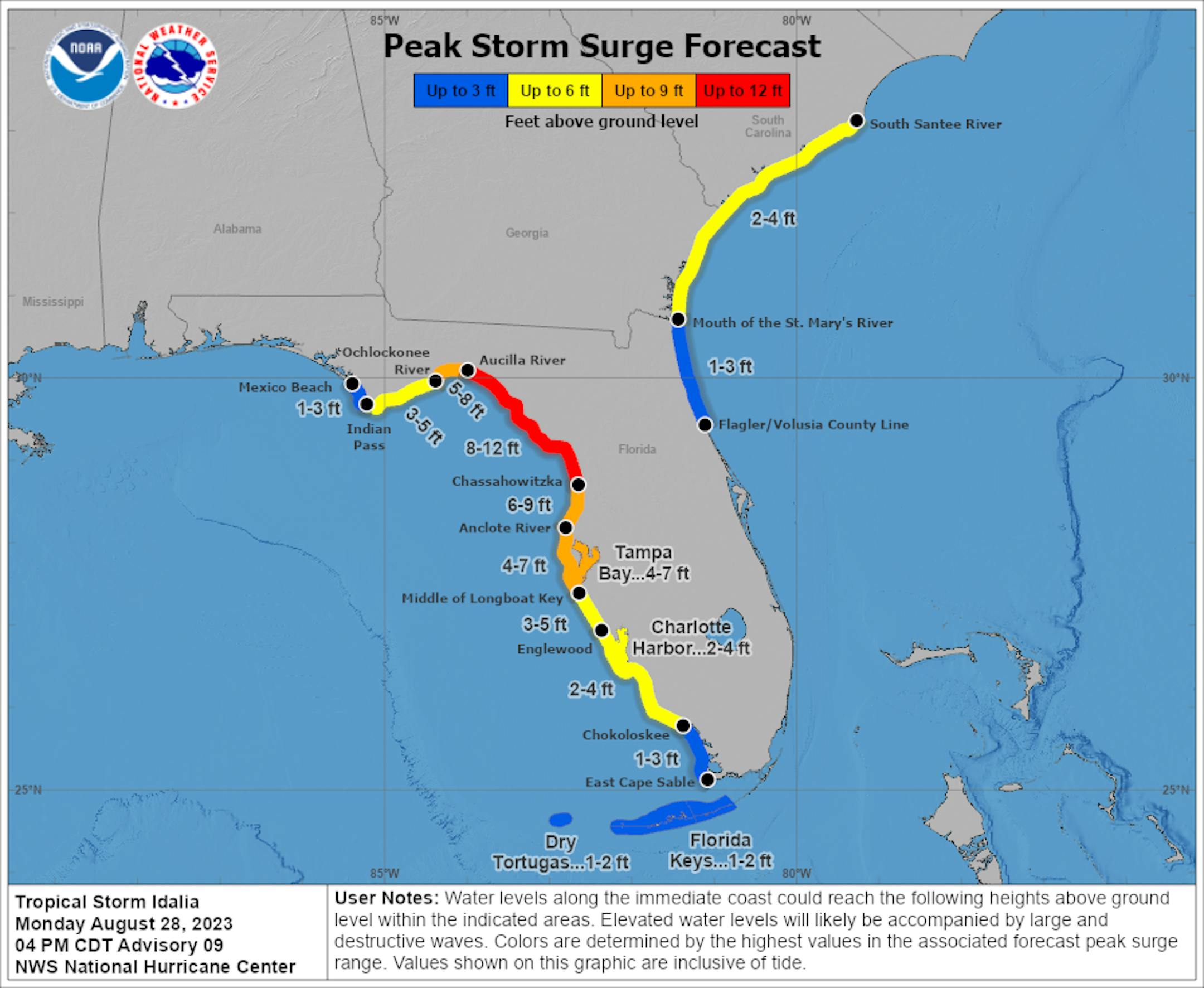
Life-Threatening Storm Surge

According to NOAA's National Hurricane Center, the biggest storm surge could reach 8ft. to 12ft across parts of Florida's Big Bend. Tampa could actually see 4ft to 7ft surge as Idalia passes to the north.

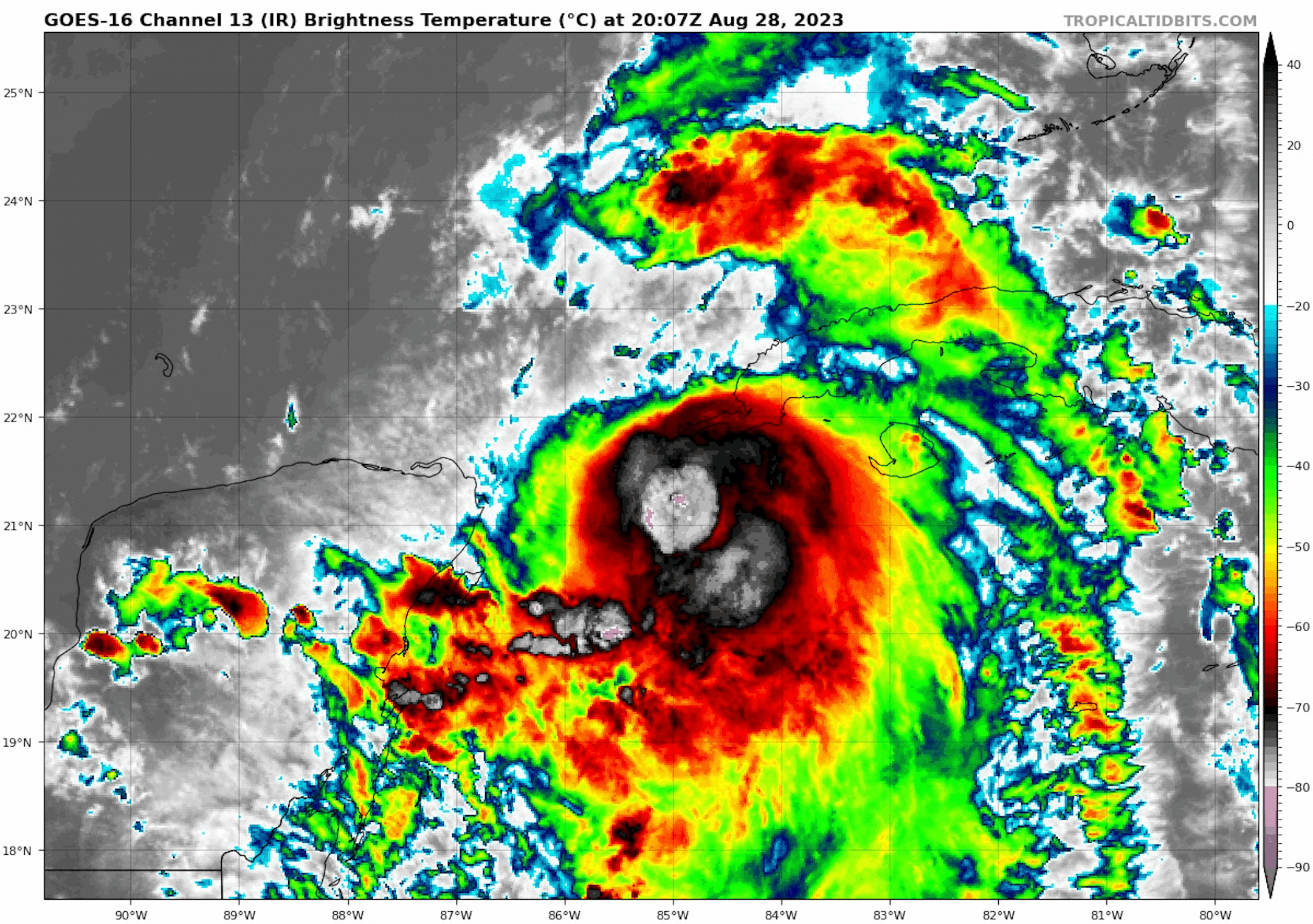
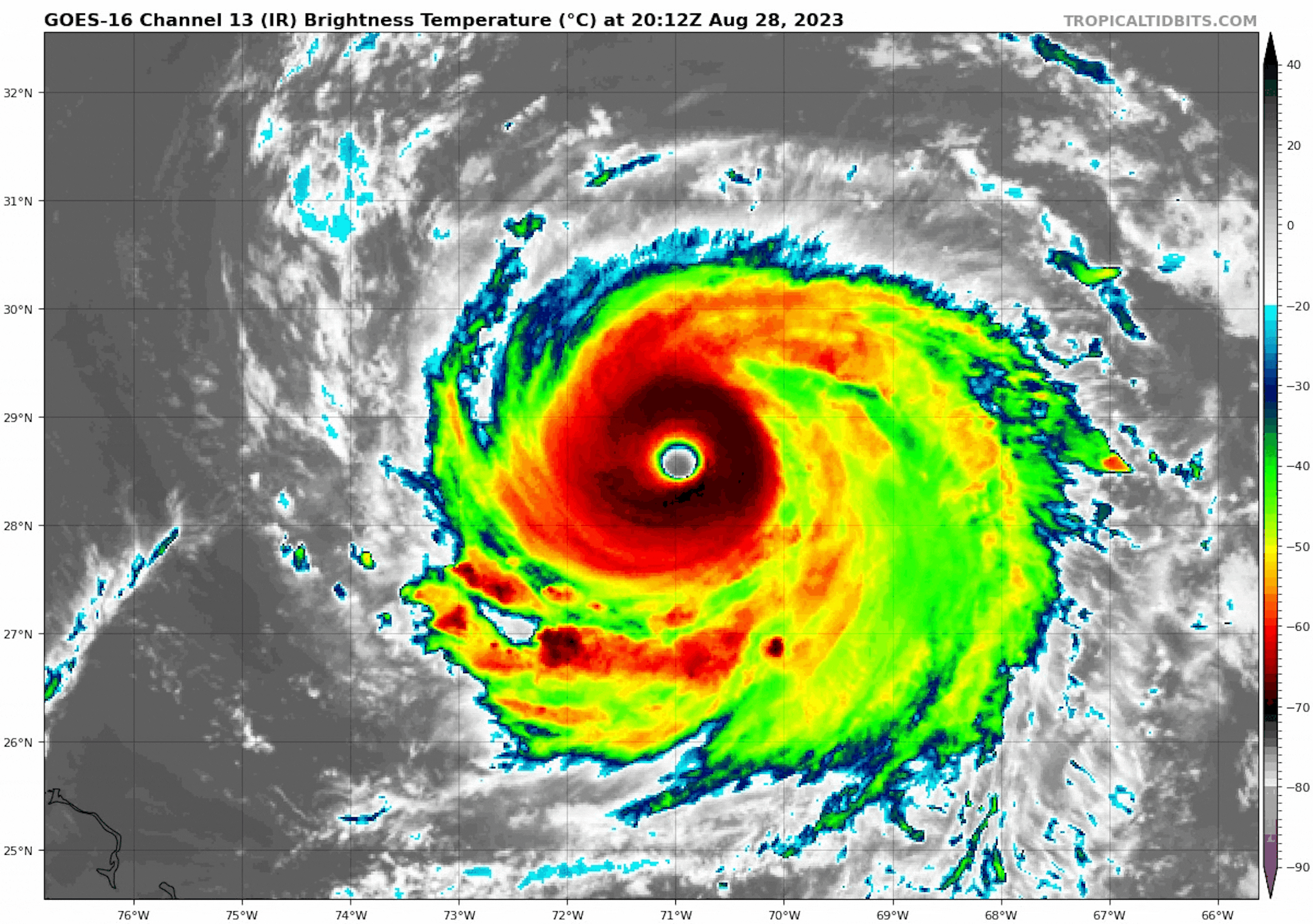
Major Hurricane Franklin

Meanwhile, Hurricane Franklin was a major category 4 storm with winds up to 145mph on Monday. Franklin was a very impressive looking storm with a definitive "eye" as seen by the IR satellite loop below.

Flying Through The Eye of Franklin

Believe it or not, pilots and researchers from NOAA actually fly through tropical system, including major hurricanes! Take a look at the video below from a recent flight through Hurricane Franklin... unreal!

See more from the Hurricane Hunters HERE:

Tracking Franklin

As of Monday, Franklin was a major hurricane with 145mph sustained winds. This storm is expected to steer north of Bermuda (thankfully), but Tropical Storm headlines have been posted for the Island as rain, gusty winds, storm surge and life-threatening rip currents will be possible.

Active Weather in the Atlantic

As of Monday, the National Hurricane Center as tracking Hurricane Franklin and Tropical Storm Idalia in the Atlantic basin. There was also another wave near the western tip of Africa that has a moderate chance of development over the next 7 days.

Atlantic Basin Climatology

Our recent uptick in the Atlantic tropical activity coincides with climatology, which suggests that things ramp up pretty quickly during the 2nd half of August and into September. This is when the sea surface temperatures are typically the warmest in the Atlantic Basin. Note that the actual peak of the season is on September 10th, which is less than 3 weeks away. With that being said, the next several weeks could be pretty active in the Tropics.

Minnesota State Fair Weather

"It's time once again for the "Great Minnesota Get Together." Weather plays quite a role in the State Fair experience. Who doesn't remember braving the heat with the crowds on one of the busier intersections on a sweltering afternoon? A quick rain burst will send people scurrying for cover, and folks savor balmy days in the 70s with just a bit of a breeze. Below are some State Fair weather facts and notable weather events that have happened in past Minnesota State Fairs. Quick History of the Minnesota State Fair The Minnesota State Fair has been held at its current site since 1885. Before that it was held at a variety of locations including Fort Snelling. There were some years when the Fair was not held because of war, disease, or for logistical reasons. These years are: 1861 (Civil War), 1862 (Civil and Indian War), 1893 (Columbian Exposition), 1945 (fuel shortage because of WWII), and 1946 (outbreak of Polio.) In 2020 the fair was not held due to COVID 19. Beginning in 1975, the fair has a 12-day run each year ending with Labor Day. Thus since 1975, the Fair begins on a Thursday in August. Before 1975, the Fair was held for shorter durations (eleven days from 1972 to 1974, ten days from 1939 to 1971, eight days from 1919 to 1938 and six days from 1885 to 1918). The 2023 Minnesota State Fair runs from August 24-Sepember 4."

See more from the State Climatology Office HERE:

Hottest Days of 2023 So Far

The hottest days of 2023 (so far) were back to back on August 22nd and 23rd, when the MSP hit 98F and heat index values peaking around 110F to 120F around the metro. Uffda! Through Sunday, August 27th, there have been (27) 90F days this year and tied for the 13th most number of 90F days in any year. The extended outlook brings us back into the 90s for the Labor day weekend, so we'll continue to add to that tally.

5th Hottest Meteorological Summer on Record

It has also been a hot summer with readings running well above average since June 1st and good enough for the 5th hottest Meteorological Summer on record so far (through August 27th). Note that 2021 was the 2nd hottest and 2022 was the 16th hottest. Meteorological Summer ends this Thursday!

Average Number of 90F Days At MSP

Looking at the last 30 years, the average number of 90F days at the MSP Airport is (14). July is the hottest month with an average of (6) 90F days. This year we've had (23) 90F days, last year we had (18) days in the 90s and in 2021 there were (27) days in the 90s. The most number of 90F days in any single year was (44) set in 1988.

9th Driest Meteorological Summer on Record

It has been very dry across much of the region so far this summer with only 5.79" of rain falling at the MSP Airport since June 1st. Interestingly, we're still -6.71" below average this summer. For reference, the driest on record was only 1.73" set in 1894.

90 Day Precipitation Anomaly

On average, the wettest time of the year is in the summer, with the months of June, July and August seeing nearly 13" of rain at the MSP Airport. If we take a look at the 90 day precipitation anomaly, which dates back to about mid May, some locations are nearly -3.00" to nearly -7.00" below average (in red/pink). Note that some locations across southeastern Minnesota are nearly -8.00" to -10.00" below average.

Drought Update

Drought continues across much of the state with a slight uptick in the Severe and Extreme categories. The greatest increase was in the Severe (D3) category, which increase nearly 11% from last week.

Extended Precipitation Outlook

It is still plenty dry across the state and the extended precipitation forecast doesn't show much in terms of any significant soakings anytime soon. There could be a little here and there over the next 7 days, but not enough to help any of the drought conditions.

Twin Cities Weather Outlook For Tuesday

The weather outlook for the Twin Cities on Tuesday, August 28th will be sunny and dry with a high temperature approaching 80F. Dewpoints will be fairly comfortable in the upper 50s during the day as well.

Meteograms For Minneapolis

Weather conditions for Minneapolis through the day Tuesday will be very comfortable. Temps will start in the lower 60s in the morning and top out in the upper 70s in the afternoon with partly cloudy skies. Winds generally be out of the north throughout the day around 10mph to 20mph.

Weather Outlook For Tuesday

Temps on Tuesday will warm into the 70s and 80s across much of the state, which will be a little warmer than average across the western part of the state. Readings will only warm into the 60s near Lake Superior, which will be a little cooler than average.

Extended Temperature Outlook For Minneapolis

The 5 day temperature outlook for Minneapolis will remain pretty comfortable through Thursday with readings hovering around 80F. It gets hot this Labor Day Weekend with highs approaching 90F, which will be quite a bit above average for early September.

More Comfortable Dewpoints.

The 5 day dewpoint forecast for Minneapolis looks pretty comfortable midweek with readings falling into the 50s once again. However, it'll get hot and sticky once again as we approaching the Holiday weekend.

Extended Weather Outlook For Minneapolis

The extended temperature forecast for Minneapolis looks decent through Thursday. However, it'll get hot and sticky once gain as we approaching the weekend and into early next week with a string of 90s developing once again.

Another Hot Week Shaping Up

According to NOAA's National Blend of Models, temps will still be pretty close to average through midweek before we warm up into the 90s through the Labor Day Weekend.

Weather Outlook

Weather conditions in the Midwest look fairly quiet over the next several days with minimal precipitation chances through next weekend. The big story will be southeast of us, where Idalia will make landfall in Florida as a possible major hurricane midweek.

8 to 14 Day Temperature Outlook

According to NOAA's Climate Prediction Center, the 8 to 14 day temperature outlook shows Warmer than average temperatures across much of the nation as we head through the first week of September. The warmest weather will once again be found in the Central US, where temps will remain well above average. The West Coast will be cooler than average into early September.

8 to 14 Day Precipitation Outlook

According to NOAA's Climate Prediction Center, much of the nation will be drier and quieter than average. Meanwhile, more active weather will be in place across the Pacific Northwest.

Tracking Dangerous Hurricane Idalia
By Paul Douglas

I live in a state of perpetual paranoia. If you're a meteorologist you sure don't want to miss a blizzard or a flood. But our version of the Super Bowl is hurricane landfall. Who will be impacted and how bad will it be? Give us a few days of lead-time to lower risk and move people to safety.

Hurricane Idalia will probably come ashore over the lightly-populated Big Bend area of the Florida Panhandle, the first Cat 3+ storm there since 1950. But the wind field around this dangerous storm is enormous, and parts of Tampa Bay may see tides rise 4-7 feet as the storm pushes north. Tell friends in the Tampa area to take this seriously and listen to local authorities.

A quiet week is on tap for Minnesota with a little smoke but no drama. A full-blown, late-summer heatwave is brewing with 90+ highs Friday into at least the middle of next week. In theory upper 90s are possible by Labor Day. So much for easing into autumn.

The pattern isn't favorable for significant rain. Hoping for a change in the weather.

Extended Forecast

TUESDAY: Sunny, cooler breeze. Winds: N 10-15. High: 81.

TUESDAY NIGHT: Hazy. Partly cloudy and quiet. Winds: ENE 5-10. Low: 59.

WEDNESDAY: Comfortable sunshine. Winds: SE 8-13. High 80.

THURSDAY: Sunny, breezy and warmer. Winds: S 10-20. Wake-up: 61. High 85.

FRIDAY: Hot sunshine. Winds: SW 10-20. Wake-up: 65. High 90.

SATURDAY: July flashback. Sunny and hot. Winds: SW 8-13. Wake-up: 68. High: 93.

SUNDAY: Sweaty sunshine. Winds: S 8-13. Wake-up: 71. High: 95.

MONDAY: Laboring to stay cool. Sizzling sun. Winds: S 10-20. Wake-up: 74. High: 96.

This Day in Weather History

August 29th

1948: An airliner crashes during a thunderstorm near Winona, killing 37 people on board.

1863: A devastating killing frost affects most of Minnesota, killing vines and damaging corn.

Average High/Low for Minneapolis

August 29th

Average High: 79F (Record: 96F set in 1969)

Average Low: 61F (Record: 45F set in 1911 & 1946)

Record Rainfall: 2.05" set in 1964

Record Snowfall: NONE

Sunrise/Sunset Times for Minneapolis

August 29th

Sunrise: 6:31am

Sunset: 7:56pm

Hours of Daylight: ~13 hours & 24 minutes

Daylight LOST since yesterday: 2 Minutes & 58 Seconds

Daylight LOST since Summer Solstice (June 21st): ~ 2 Hour & 13 Minutes

Moon Phase for August 29th at Midnight

0.8 Days Until The Full "Blue" Moon

"Aug. 30 at 8:36 p.m. CDT - The second full moon occurring within a calendar month is usually bestowed this title. Although the name suggests that to have two Full Moons in a single month is a rather rare occurrence (happening "just once in a . . . "), it actually occurs once about every three years on average. There is actually a second and more arcane definition of a Blue Moon, apparently conceived by an almanac editor based in Maine back in the 1930s, but we will not get into this here. In addition, the moon will also be at perigee at 12:00 p.m. EDT., at a distance of 221,942 miles (357,181 km) from Earth. Very high tides can be expected from the coincidence of perigee with full moon (referred to as an astronomical spring tide). Finally, a full moon occurring very late in August or very early in September is sometimes bestowed with the title of Fruit Moon or Barley Moon. This will be the case with this second August full moon in 2023."

See more from Space.com HERE:

National High Temps on Tuesday

Temperatures on Tuesday will be well above average across the Intermountain-West, where readings will be well above average for this time of the year. Folks in the Northwest and the Northeast will be cooler than average for the end of August.

National Weather Tuesday

The weather outlook on Tuesday will be a little unsettled across the Eastern US with showers and storms. Idalia will begin moving into the Southeast and Florida with outer bands moving in later in the day.

National Weather Outlook

The weather outlook through Wednesday will be very unsettled across the Southeastern US, where Idalia will move through. Widespread damage significant impacts will be felt through midweek.

Extended Precipitation Outlook

The extended precipitation outlook shows areas of heavy rainfall across the southeastern US as Idalia moves through. Some of the rainfall amounts could approach 10" or more.

Climate Stories

"Opinion Wildfires move a mile a minute. The U.S. can't ignore the warnings"

"Maui officials should have known what was coming. In 2014, they were put on notice that highly flammable invasive grasslands presented a serious wildfire risk. In 2018, after West Maui fires destroyed 21 houses and 27 cars, angry residents criticized the poor disaster response. The next year, wildfires charred five times more land in Maui County compared with the previous year, and Hawaiian Electric admitted it needed to better fortify its power lines. In 2021, another report came out urging officials to clear flammable grasses. Again and again, the warnings came. Days before the deadliest U.S. wildfire in more than a century, weather forecasters warned that fierce winds would give life to dangerous fire conditions across much of the island, offering still more time to coordinate potential evacuation plans. As the fires barreled toward neighborhoods, officials failed to activate its expansive All-Hazard Statewide Outdoor Warning Siren System, instead opting for digital and radio communications many residents say they never got. At least 115 people have died, and more than 300 are missing. In the aftermath, leaders said "nobody saw this coming," but that is wrong."

See more from Washington Post HERE:

"Scientists Design a Colorful New Paint That Could Cut Your Electricity Bill"

"Scientists at Stanford University have designed a new paint that could help reduce our growing reliance on air conditioners and heaters. It comes in an array of colors, and if used properly, it could seriously slash electricity bills and emissions. The paint is capable of reflecting up to 80 percent of mid-infrared light from the Sun, which is 10 times more reflection than conventional colored paints. Mid-infrared light is usually absorbed as heat on building surfaces. When used on the outside of a building, the paint keeps heat out, and it can be used on the inside to keep heat in. As such, the developers of the paint say it provides a "year-round energy-saving solution" that can be used in a variety of climates. When tested in artificially warm conditions, the paint reduced the amount of energy needed to cool the enclosed space by almost 21 percent. Tested in artificially cold conditions, it reduced the energy needed to heat the space by 36 percent."

See more from Science Alert HERE:

"Study finds heat waves are becoming more frequent and more deadly"

"The risk of fatal heat waves has risen sharply over the past 20 years. In the future, such extreme weather will become more frequent and heat-related excess mortality will increase. Europe will be particularly affected, as ETH Zurich researchers show. Heat waves of the kind we are currently experiencing are particularly deadly for the elderly, the sick and the poor. The 2003 heat wave, which saw temperatures in Europe reach 47.5°C, was one of the worst natural disasters of recent decades, claiming an estimated 45,000 to 70,000 victims in the space of a few weeks. Forests burned, crops withered in the fields and emergency wards in the cities were full to capacity. Globally, costs totaled around 13 billion US dollars. Nevertheless, the public remains less aware of the risks of heat waves than of other climate-related extremes. This is a problem, as a study published in the journal Nature Communications points out. Heat waves like the one we saw in 2003 could become the new norm in the coming years."

See more from Phys.org HERE:

Thanks for checking in and don't forget to follow me on Twitter @TNelsonWX