Ice Safety Guidelines

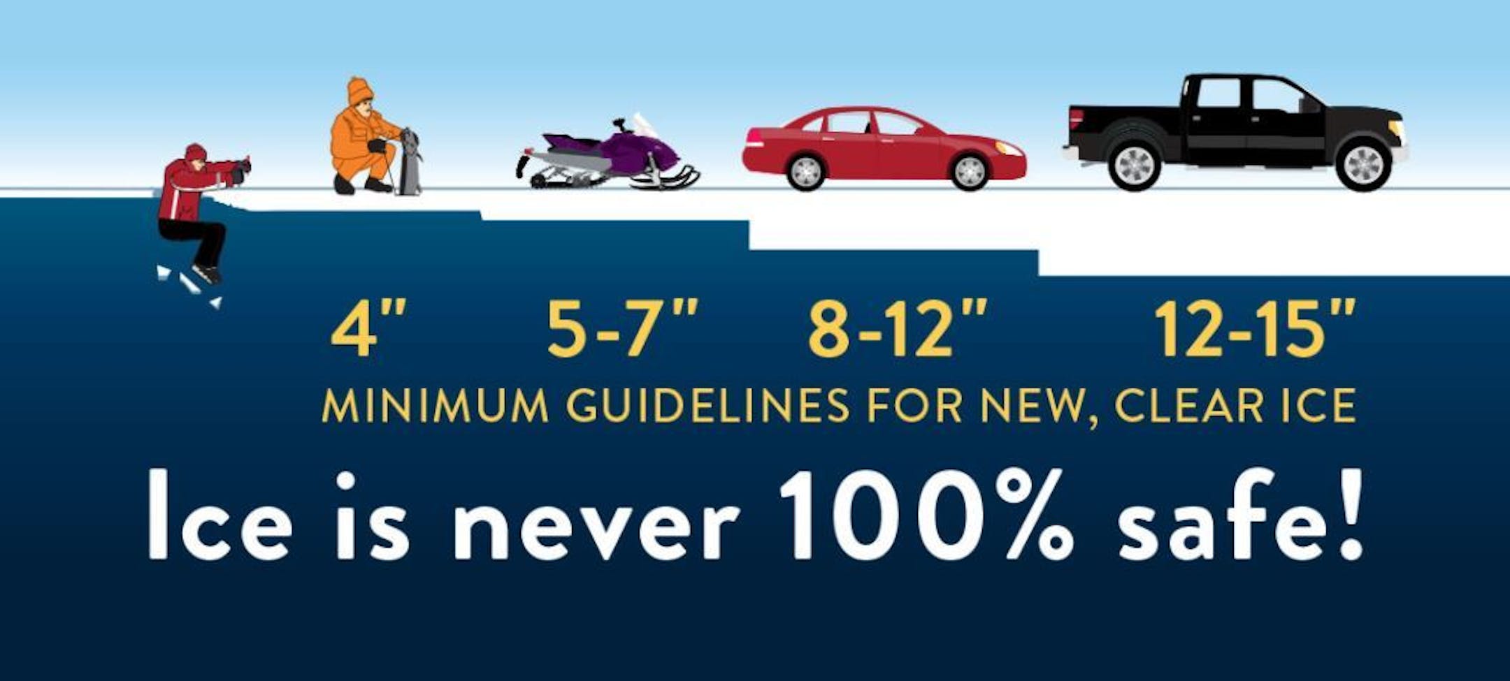
We've had several nights sub-freezing across the state and with that, ice is forming on area lakes and ponds. Keep in mind that many lakes around that state are still not safe to venture out on as of yet! Note that ice is never 100% safe, but you need at least 4" of ice to safely walk on. Stay safe out there!!

See more Ice Safety Guidelines from the MN DNR HERE:

Minneapolis December Summary So Far

Here's a look at the December number so far and through the first few days of the month, MSP is nearly +10 degrees above average! It has also been a dry start with only 0.01" of precipitation falling. We've also only had 0.2" of snow, which is nearly -4.0" below average through the first part of the month.

Least Snowy Decembers

"MSP managed to pick up 0.2" of snow last Saturday, December 5th. Note that we're on track to have the 3rd least snowy December at MSP on record. Interestingly, there was only a Trace of snow in 1943 and 1913. We still have about 3 weeks left of the month and a lot can happen between now and then. Stay tuned!

Snow Depth As of December 10th

Interestingly, the Twin Cities has seen more than 18" of snow so far this season, but with several days that have been warmer than average, we don't have much snow left on the ground. There are still a few inches on the ground in the Arrowhead and in northern Wisconsin.

Snow Depth From 2019

Take a look at how much different our snow coverage was last year at this time. Note that much of the state had snow on the ground with the heaviest tallies close to the head of Lake Superior. According to the report at the MSP Airport from December 12th of last year, there was 7" of snow on the ground at this time last year and we also had 6" of snow on the ground on Christmas Day. Duluth on the other hand had 21" of snow on the ground at this time last year and had 18" of snow on the ground on Christmas Day.

Snowfall So Far This Season

Hard to believe, but the Twin Cities has already had 18.3" of snow this season, which is still about +4" above average. Duluth has had more than 30" of snow, which is nearly +10" above average.

Large Storm Sails South of MN This Weekend

Earlier this week, it looked like we might've had a chance at accumulating snow close to home, but that system has since pushed out. Folks from Iowa to Wisconsin and Michigan will have the best potential of shovelable snow through the first half of the weekend.

7 Day Snowfall Potential

The weather maps have been extremely quiet as of late, but the GFS is advertising a larger storm system moving through the Upper Midwest by next weekend. It's still WAY too early to get detailed. It's also possible that this storm may not even materialize, but it's the most exciting thing I've seen in the weather models in quite some time. Stay tuned!!

Weekend Weather Outlook for Minneapolis

Weather conditions this weekend look pretty quiet with temps running closer to average, but once again, we'll stay mostly dry! Note that the average high in the metro is in the upper 20s for this time of the year.

Saturday Weather Outlook for Minneapolis

Here's the weather outlook for Saturday, which shows partly to mostly cloudy skies continuing. However, temps will be warm to slightly above average levels once again with readings close to the freezing mark

Saturday Meteograms for Minneapolis

Here's a look at the Meteograms for Saturday. Note that our average low for this time of the year is in the lower teens, so temps will actually be quite a bit warmer than average on the low side. However, the high temp will only be slightly above average. Sky conditions will remain mostly cloudy throughout the day as well.

Saturday Weather Outlook

High temps on Saturday will still be running above average across much of the region under mostly cloudy skies. Areas of snow will be found just southeast of Minnesota across parts of Iowa and Wisconsin.

Extended Temperature Outlook For Minneapolis

Here's the extended temperature outlook for the Twin Cities, which shows temps running a little closer to average and we head into next week. Note that highs will still be nearly +5F above average this weekend with readings topping out in the lower 30s, but we'll chill down with highs only in the 20s next week. Again, note that we don't have much precipitation (or snow) in the forecast anytime soon.

Extended Temperature Outlook For Minneapolis

The extended temperature outlook through Christmas doesn't show any major Arctic smacks moving through. It does look like we chill down a bit early next week, but could then gradually warm to above average levels again by next weekend.

Drought Update

According to the US Drought Monitor, drought conditions have increased slightly over the last few weeks with nearly 77% of the state considered to be in abnormally dry, while almost 11% is considered to be in a moderate drought. Precipitation in Duluth is -9.92" below average and is considered to be the 9th driest (January 1st - December 10th) on record. Meanwhile, Sioux Falls, SD is at their 7th driest such period on record.

8-14 Day Precipitation Outlook

According to NOAA's Climate Prediction Center, precipitation potential appears to be going up across the nation, especially through the Mississippi River Valley and Great Lakes Region. After several days and weeks of dry weather across much of Minnesota, we may see a bit of a shift towards more active weather closer to home. Stay tuned!

8-14 Day Temperature Outlook

According to NOAA's Climate Prediction Center, warmer than average temperatures will continue across MUCH of the nation as we ahead into the week of Christmas. However, folks in Alaska should remain below average in the temperature department.

Snow Drought Lingers Into Christmas
By Paul Douglas

"Dear Santa, all I want for Christmas is a couple of ice-cold Pfizer vaccines, a monogrammed Star Tribune mask and affordable health insurance!" And a rerun of family gatherings, friendly lunches and "vacations" in 2021. Americans have never been good at delayed gratification. Experts say the next few months will test our willpower and resolve.

Meanwhile, the short answer to "Will there be a white Christmas?" is "Probably not". Models hint at a little slush next weekend; maybe a snowy coating Christmas Day - but ingredients required for a big, beefy snowstorm are lacking.

The first 10 days of December may have been the 4th or 5th warmest on record statewide, according to Dr. Mark Seeley. In spite of a few chilly days next week a mild, Pacific bias continues through Christmas.

Unless you want to become nearer my God to thee, stay off the ice in the metro area. It's not even close to being safe yet.

Farmers have a saying that resonates. "When in a drought, don't predict rain." Or snow, it seems.

Extended Forecast

SATURDAY: Mostly cloudy and chillier. Winds: NE 10-20. High: 32.

SATURDAY NIGHT: Decreasing clouds. Winds: NW 5-10. Low: 24.

SUNDAY: Partly sunny skies and quiet. Winds: SW 8-13. High: 34.

MONDAY: Chilled sunshine. Winds: NW 7-12. Wake-up: 17. High: 23.

TUESDAY: Mostly cloudy and brisk. Winds: SE 7-12. Wake-up: 15. High: 25.

WEDNESDAY: More clouds than sun. Winds: SE 5-10. Wake-up: 18. High: 28.

THURSDAY: Patchy clouds. Still quiet. Winds: SE 5-10. Wake-up: 21. High: 31.

FRIDAY: Few snow showers possible, Winds: SW 10-20. Wake-up: 26. High: 33.

This Day in Weather History

December 12th

2004: A strong cold front pushes through Minnesota during the early morning hours. By dawn, winds turn to the northwest and increase to 25 to 40 MPH with gusts as high as 70 MPH. The windiest part of the day was from mid morning through mid afternoon when many locations suffered sustained winds in the 30 to 45 MPH range. The highest wind gusts recorded in southern Minnesota during this time included 71 MPH in Welch and 62 MPH near Albert Lea, St. James, Winthrop and Owatonna. Other notable wind gusts included 59 MPH at New Ulm, 58 MPH in Mankato, 55 MPH in St. Cloud and Morris, 54 MPH at Redwood Falls, and 52 MPH at the Minneapolis/St. Paul International Airport. Scattered trees were downed and a few buildings received minor roof damage across the region.

1939: A December gale along the North Shore leads to winds clocked at 48 mph at Duluth.

Average High/Low for Minneapolis

December 7th

Average High: 28F (Record: 53F set in 1968)

Average Low: 13F (Record: -15F set in 1879)

Record Rainfall: 0.61" set in 1886

Record Snowfall: 4.6" set in 1941

Sunrise/Sunset Times for Minneapolis

December 7th

Sunrise: 7:42am

Sunset: 4:32pm

Hours of Daylight: ~8 hours & 49 minutes

Daylight LOST since yesterday: ~43 seconds

Daylight LOST since Summer Solstice (June 20th): ~ 7 hour & 1 minute

Moon Phase for December 12th at Midnight

1.4 Days Before New Moon

See more from Space.com HERE:

What's in the Night Sky?

"On the mornings of December 11, 12 and 13, 2020, look east before sunrise. The waning crescent moon and dazzling planet Venus will be beautiful in your early-morning sky. Note that the illuminated or day side of the moon will be pointing right at Venus on December 11 and 12. The lit side of a waning crescent moon always points eastward, or in the moon's direction of travel in front of the constellations of the zodiac. Because the moon and Venus rank as the second-brightest and third-brightest celestial bodies, respectively, after the sun, you should have little trouble viewing these brilliant worlds in the glow of dawn. While you're viewing the morning tableau, check out the dark or nighttime side of the moon. You might see it as softly illuminated by earthshine – twice-reflected sunlight – that is, sunlight that's bounced from Earth to the moon, and then from the moon back to Earth. And the waning moon and Venus aren't just pretty on these mornings. They're a prelude of drama to come!"

See more from Earth Sky HERE:

National High Temps Saturday

Here's a look at high temps across the nation on Monday, which shows warmer than average temperatures across much of the western half of the nation. Meanwhile, folks along the East Coast will be cooler than average by -5F to -10F

National Forecast Map For Saturday

The weather map on Saturday look a little more active across the nation with a bigger storm system moving into the eastern half of the nation. Showers, storms and locally heavy rainfall will be possible on the warmer side of the storm, while areas of heavier snow will be possible on the colder side of the storm, mainly into the Great Lakes Region. There will also be another surge of Pacific moisture that moves into the Western US with heavier coastal rains and mountain snow.

National Weather Outlook

Here's the weather outlook through the weekend, which shows a fairly large storm system wrapping up across the Great Lakes Region. Meanwhile, the Western US will remain active with a number of areas getting in on decent rain and snow potential!

Heavy Precipitation in the Western US

Here's the precipitation potential over the next 7 days. Note that areas of heavier precipitation will be possible across the Mississippi River Valley and into the Eastern US, while heavier precipitation will be possible in the Western US.

7 Day Snowfall Potential

Here's the 7 day snowfall potential across the nation, which shows decent snowfall potential across the Western US and across parts of the Central and Eastern US. However, note that much of Minnesota will stay, for the most part, snow-free through the next several days.

Climate Stories

"Current pace of action on climate change is "unthinkable" state ex UN climate leaders"

"Justifiable pride can be taken in the incremental accomplishments of international climate change cooperation, but it is "unthinkable" to continue at the current pace. The global response to climate change is completely insufficient and leaves the world on a "road to hell". That's according to four former senior members of the United Nations Framework Convention on Climate Change (UNFCCC) secretariat, who have published an exclusive critical insider insight piece -today published in the peer-reviewed journal, Climate Policy. In reviewing 30 years since the launch of international negotiations on climate change, the team state that while countries have successfully agreed three significant UN treaties over the three decades, global implementation of the ensuing commitments is failing, and ramped up action is required urgently "to avoid dangerous climate change" and to stay within agreed temperature increase thresholds."

See more from Phys.org HERE:

"Scientists explain why aurora borealis not visible from U.S."

"If you were planning to view the northern lights in Montana on Thursday night, chances aren't as great as originally predicted. The geomagnetic storm watch has been downgraded from a G-3 to a G-1, which means the lights will not be visible from the United States. Scientists at NOAA Space Weather Prediction Center explained how the aurora borealis make their appearance on Earth and why they are so difficult to predict. Solar flares on the sun is how it all begins. Coronal mass ejections are associated with solar flares. CMEs blast clouds of material into outer space. "If it's pointed in the right direction and comes quickly enough, it can activate Earth's magnetic field system and create aurora," said Rodney Viereck, a scientist with the Space Weather Prediction Center. Based on data gathered Wednesday night, Viereck said it appears the CME only grazed the Earth, rather than coming into direct contact with it. That's why viewing impacts were minimal, and the watches have been degraded."

See more from NBC Montana HERE:

"Meet The 15-Year-Old Activist Fighting For Better Climate Education"

"In 2018, the state of California was on fire. Alexandria Villaseñor, who was 13 at the time, was traveling between her hometown of Davis, California, to her mother's temporary residence in New York City, when she witnessed the destruction of Northern California's Camp Fire, which would go on to burn more than 150,000 acres of land. As her family stuffed wet towels under their doors to keep out smoke from fires miles away from their home, Villaseñor was scared. This couldn't be the new normal. Before the Camp Fire, Villaseñor knew about as much as any other young teen about climate change: Go green. Reduce, Reuse, Recycle. But, as Villaseñor, now 15, is aware, the conversation was bigger than individual action. California's wildfires have continued to get worse — in 2020, more than 8,200 state-wide fires burned a record-breaking 4 million acres of land, killing 31 people. And, as Villaseñor says, ongoing climate change is only going to make things worse. She quickly realized the fight requires international, government-level changes. For her, what started as local concern turned into a year-long protest in front of the United Nations' New York City headquarters and a global campaign for more robust climate education."

See more from Mashable HERE:

Thanks for checking in and don't forget to follow me on Twitter @TNelsonWX