"NASA warns July 2023 likely to be warmest month on record"

"The extreme temperatures across continents are no surprise, say NASA's top scientists. They believe there's a "50-50 chance" that 2023 will be the hottest year on record, with next year likely even warmer. July of 2023 is likely to be the warmest month on record in "hundreds, if not thousands, of years," said NASA's top scientists in a roundtable with reporters, warning that the heat is only going to get worse. "We are seeing unprecedented changes all over the world. The heatwaves that we are seeing in the US, in Europe, China, and demolishing records left, right and center. This is not a surprise," said Gavin Schmidt, Director of the NASA Goddard Institute for Space Studies. June of 2023 was already the hottest June on record and July is likely to be the hottest month overall. "We know from science is that human activity, principally greenhouse gas emissions, are unequivocally causing the warming we are seeing on our planet," Kate Calvin, NASA chief scientist and senior climate adviser, said at the same briefing."

See more from DW HERE:

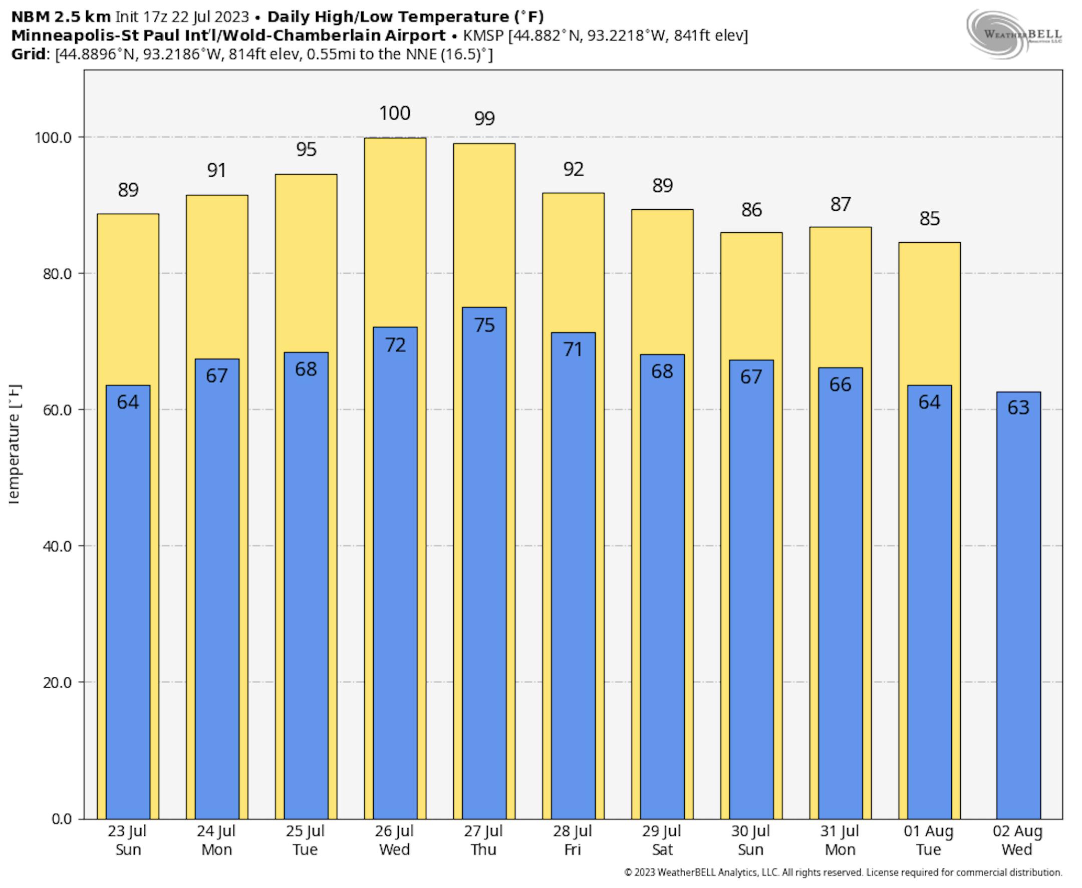
The Hottest Week of 2023 Coming Up

The week ahead will likely be the hottest week of 2023 for Minneapolis. According to NOAA's NBM model, we could see highs in the 90s all week with hottest readings peaking around 100F on Wednesday and Thursday. The National Weather Service will likely issued heat headlines this week.

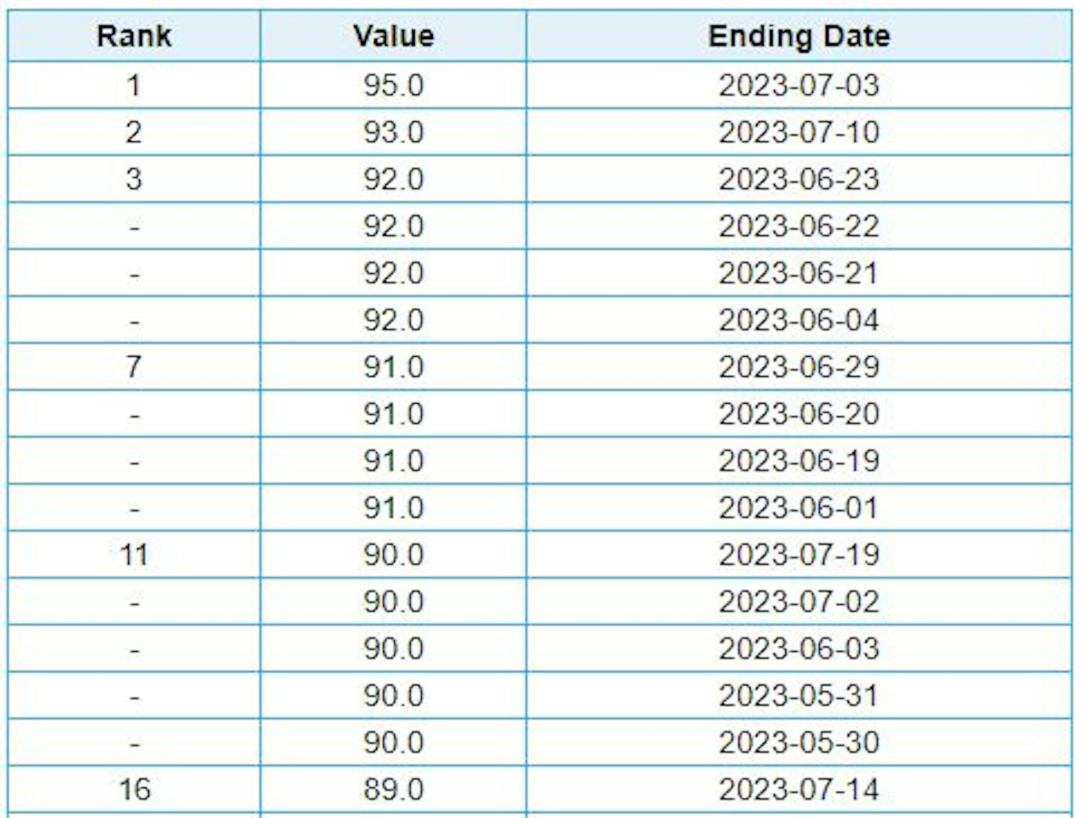
Warmest Days of 2023 So Far

Here are the warmest 16 days of 2023 so far. Note that we've (15) days in the 90s, which is more than what we typically average in a given year of (14) days. The warmest day was 95F on July 3rd, but we could surpass that a couple/few times this week. Stay tuned...

Average Number of 90F Days At MSP

Looking at the last 30 years, the average number of 90F days at the MSP Airport is (14). July is the hottest month with an average of (6) 90F days. We've only had (3) days in the 90s this July, but have already had (14) days in the 90s this year. Last year we had (18) days in the 90s and in 2021 there were (27) days in the 90s. The most number of 90F days in any single year was (44) set in 1988.

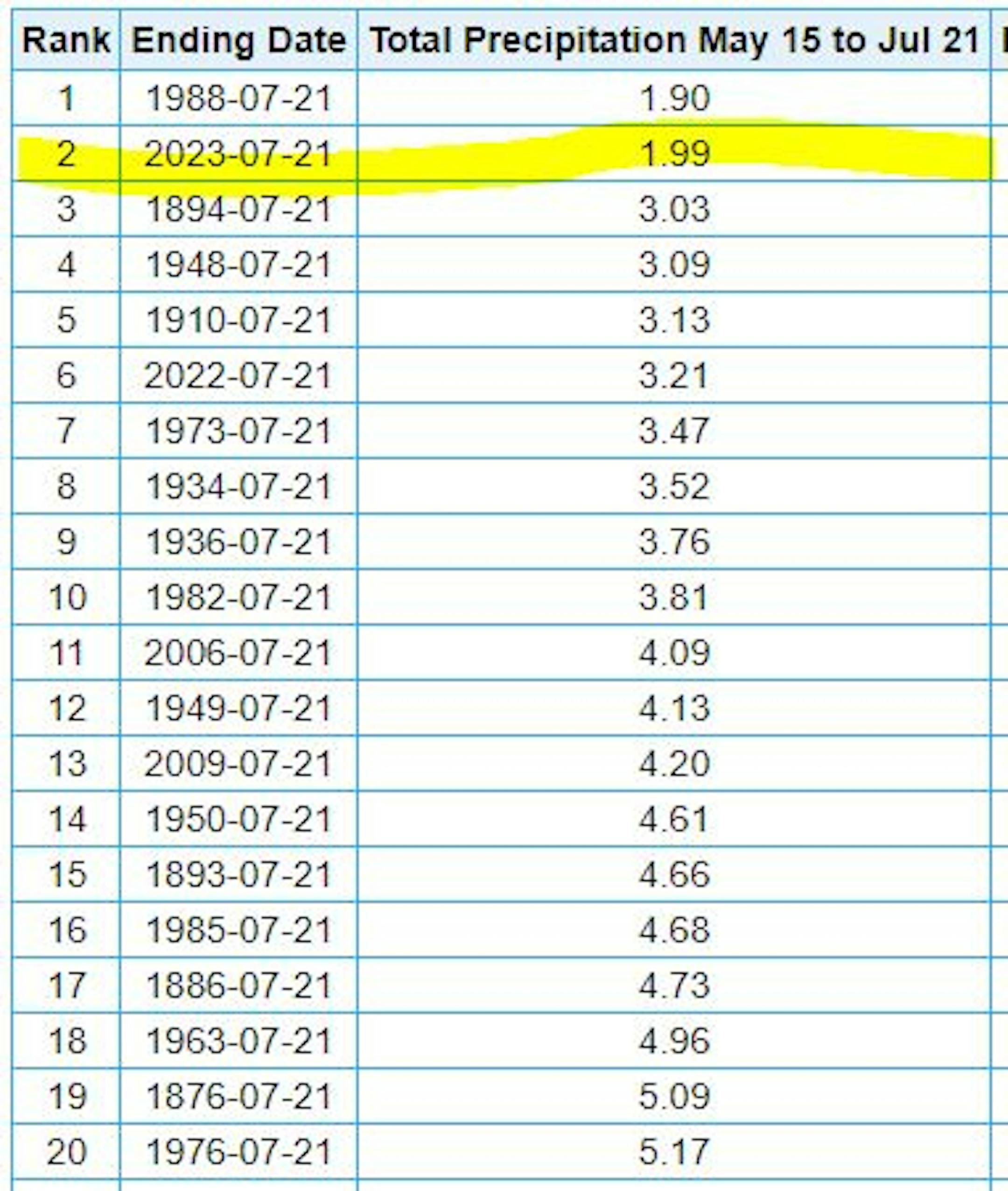
2nd Driest May 15th Through July 21st on Record

It has been very dry across much of the region this summer with only 1.99" of rain falling at the MSP Airport from May 15th to July 21st. This is the 2nd driest such period on record with the driest being 1.90" set in 1988.

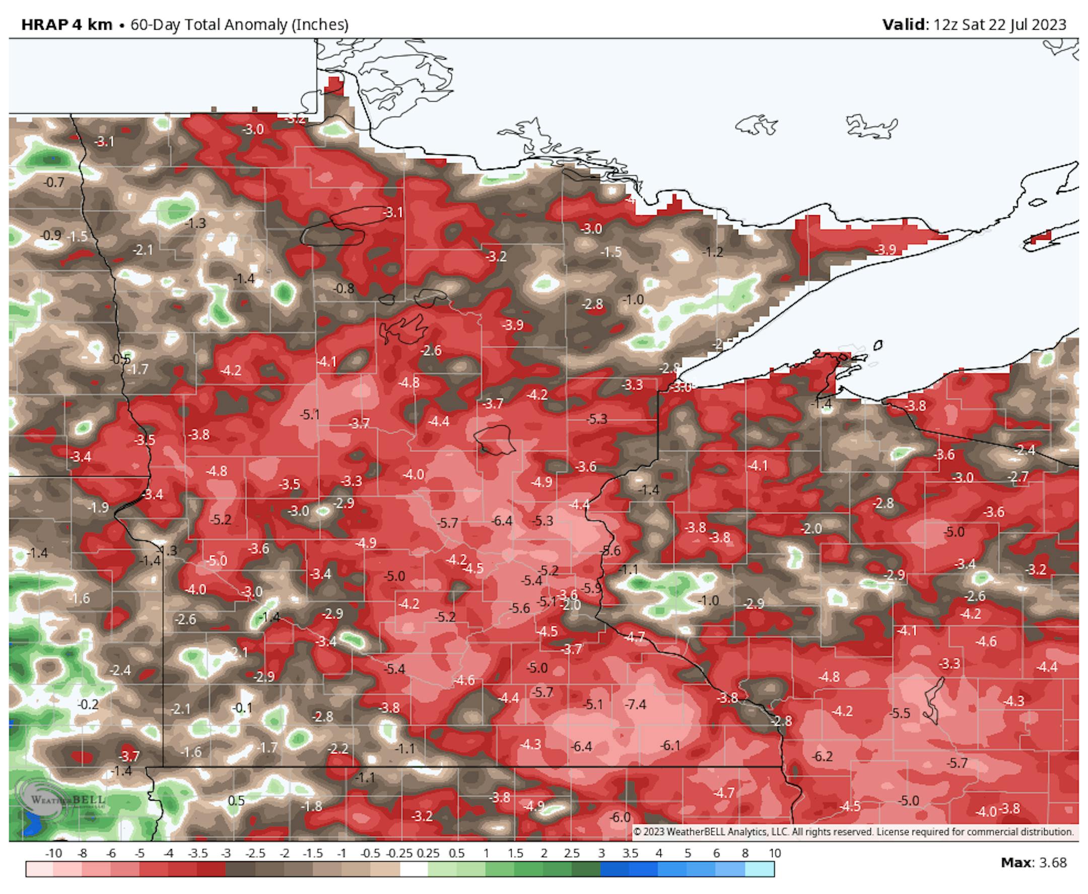
60 Day Precipitation Anomaly

The map below shows the 60 day precipitation anomaly, which indicates that some locations are nearly -3.00" to nearly -7.00" below average (in red/pink) since mid May. Spots in Southwestern and northwestern Minnesota still have a bit of a surplus, but much of the region is well below average precipitation.

Drought Update

Drought conditions continue to deepen across the region with a few pockets of Extreme Drought now showing up (in red). The last time that parts of Minnesota were in an Extreme Drought was back in mid December, nearly 7 months ago.

Extended Precipitation Outlook

The extended precipitation outlook through next week shows a few pockets of heavy rainfall, but mainly across the northern part of the state. Some locations there could see close to 0.50", but most locations will once again be dry during this very hot week of July.

Simulated Radar

The simulated radar from early AM Sunday to Monday Night shows isolated showers and storms possible across parts of the region on the leading edge of some major heat that will pour in to the region this week. Some of the storms could produce locally heavy rainfall, but the threat for widespread heavy rain is pretty minimal.

Twin Cities Weather Outlook For Sunday

The weather outlook for the Twin Cities on Sunday, July 23rd will be fairly quiet and very summery with highs warming into the mid/upper 80s in the afternoon. Skies will generally be sunny, but there will be a few could and isolated t-showers that bubble up later in the afternoon, mainly north of the metro.

Meteograms For Minneapolis

The hourly temps through the day Sunday shows temps starting in the lower 60s in the morning and topping out in the upper 80s in the afternoon. Skies will be mainly dry with a few more clouds in the afternoon. Northwesterly winds will be fairly light through the day.

Weather Outlook For Sunday

Temps on Sunday will warm into the 80s across much of Minnesota with a few 70s across the northern part of the state. There could be a few t-showers farther north during the afternoon as well. Note the 100s across South Dakota, this is the building heat that will be with us during the week ahead.

Extended Temperature Outlook For Minneapolis

The 5 day temperature outlook for Minneapolis shows a very warm week ahead with readings warming into the 90s, which will be well above average even for July standards. The warmest days will be Wednesday and Thursday with highs approaching the century mark. Note that the last time we hit 100F in the Twin Cities was on June 20th, 2022. If we hit 100F this week, it'll be the 70th time in history!

Stickier Dewpoints Linger Early This Week

The dewpoint forecast over the next several days shows a gradual increase in humidity into what will likely be one of our hottest weeks of 2023. By Wednesday and Thursday, dewpoint readings will approach 70F, which is almost tropical!

Extended Weather Outlook For Minneapolis

The extended weather outlook for the Twin Cities into our last full week of July shows very hot temps moving in. As the heat moves in, there could be a few showers and storms, but most will stay dry as the heat bubble moves in.

Weather Outlook

Weather conditions across parts of the Central US will be unsettled at times with chances of showers and thunderstorms drifting through. There could be a few isolated severe storms with locally heavy rainfall. The large ridge of high pressure in the Western US will be responsible for a few monsoonal storms.

8 to 14 Day Temperature Outlook

According to NOAA's Climate Prediction Center, the 8 to 14-day temperature outlook shows warmer-than-average temperatures across much of the nation and especially across the Deep South. Meanwhile, folks in the Northeast will be a little cooler than average for the end of July and early August.

8 to 14 Day Precipitation Outlook

More unsettled weather will be possible across parts of the Intermountain-West and into parts of the Midwest. It has been dry in the Midwest, so any rain would be welcomed.

Hottest Stretch of Summer Next Week
By Paul Douglas

Sorry Marvel, not all superheroes wear capes. Some wear stethoscopes and surgical masks. Doctors and nurses at Minnesota Children's Hospital in St.Paul saved my 3-year old grandson's life 2 weeks ago. Jordan battled pneumonia, E.coli and septic shock in the ICU, but critical care pediatric specialist Dr. Alicia Teagarden and wonder-nurse Thuy Pham headed up an amazing effort. Yes, winters are challenging, but we live in a resort with great schools and the best healthcare on Earth. My thanks to doctors and nurses performing miracles on a daily basis.

Doctors in Arizona report at least 257 heat-related deaths in recent weeks with many burn-related injuries. Temperatures on black, asphalt surfaces have reached 180F. Unreal.

We get a taste of that heat dome this week with mid to upper 90s Tuesday into Thursday, and a PM heat index near 105F by midweek. 100F air temperature sare possible just south/west of MSP.

Friday T-storms may pop, with smoky Canadian air "cooling" us into the 80s next weekend. Whew...

Extended Forecast

SUNDAY: Warm sunshine, dry. Winds: NW 7-12. High: 88.

SUNDAY NIGHT: Partly cloudy and quiet. Winds: SSW 5-10. Low: 68.

MONDAY: Smoky sunshine, heating up. Winds: S 8-13. High: 91.

TUESDAY: Sunny, plenty-hot. Winds: SE 5-10. Wake-up: 69. High 93.

WEDNESDAY: Sizzling sunshine, feels like 105F. Winds: S 8-13. Wake-up: 71. High: 97.

THURSDAY: Sweaty sunshine, sauna-like. Winds: S 8-13. Wake-up: 74. High 98.

FRIDAY: Chance of showers, few T-storms. Winds: NW 8-13. Wake-up: 72. High 91.

SATURDAY: Early thunder, slightly cooler. Winds: N 7-12. Wake-up: 68. High: 88.

This Day in Weather History

July 23rd

1987: The greatest deluge ever recorded begins in the Twin Cities, with 10 inches of rain in six hours at MSP airport.

Average High/Low for Minneapolis

July 23rd

Average High: 84F (Record: 105F set in 1934)

Average Low: 66F (Record: 47F set in 1876)

Record Rainfall: 9.15" set in 1987

Record Snowfall: NONE

Sunrise/Sunset Times for Minneapolis

July 23rd

Sunrise: 5:48m

Sunset: 8:49pm

Hours of Daylight: ~15 hours & 1 minutes

Daylight LOST since yesterday: 2 Minute & 1 Second

Daylight LOST since Summer Solstice (June 21st): ~ 35 minutes

Moon Phase for July 23rd at Midnight

1.6 Days Before New Quarter Moon

See more from Space.com HERE:

National High Temps on Sunday

Temperatures on Sunday will still be extremely hot across the Western US with a few records possible in the Southwest. Monsoonal thunderstorms will also be possible in the Southwest.

National Weather Sunday

The weather outlook on Sunday will feature isolated thunderstorms across parts of the nation, some of which could be a little strong in the Southeastern US and also across parts of Arizona.

National Weather Outlook

The weather outlook through Monday shows scattered storms along the Gulf coast and also in the Desert Southwest. Some of the storms could be strong with gusty winds and locally heavy rainfall.

Extended Precipitation Outlook

According to NOAA's Weather Prediction Center, the extended precipitation outlook shows heavier precipitation across parts of the Southern US. There could also be a few pockets of heavy rain in the Great Lakes and Eastern Canada.

Climate Stories

"Overnight minimums skyrocket as WMO pleads for more early warnings"

"Effective early warning systems need to be implemented quickly in light of prolonged heat conditions in the northern hemisphere and the prospect of lengthier, hotter heatwaves, says the World Meteorological Organization. Europe and North America have baked through July with record-breaking heatwaves most keenly felt in Italy, France and Spain and the US, with many local maximum temperature records being smashed. Forecasters are warning there are more heatwaves to come throughout August. The heatwave covering much of the west and southern USA over the last week impacted 100 million people, with excessive heat warnings issued across the states of California, Nevada, Arizona and parts of Utah, Texas and Oklahoma. But pushing the mercury to new levels isn't the only issue confronting nations. Overnight minimums are also peaking at record highs, offering people little respite from heat. "We need the world to broaden its attention beyond the maximum temperature alone," says WMO extreme heat senior advisor Dr John Nairn."

See more from Cosmos Magazine HERE:

"Mistakes People Make When Traveling During A Heat Wave"

"Record-setting heatwaves have been making headlines this summer and are likely to continue in the coming weeks. That means those with upcoming travel plans should be extra sure to pay attention and take proper precautions. "Enjoying the sun is all part of going on vacation, especially if you live in a country where good weather is a rare occurrence, but the temperatures some popular tourist destinations are experiencing are extremely dangerous, and many people won't have dealt with temperatures like this before," said Navin Khosla, a pharmacist at telehealth and online pharmacy company Now Patient."

See more from Huffington Post HERE:

"Extreme heat: Why it's a global health issue and what we can do about it"

"Around the world, temperature records are being upended, and large parts of Asia, Europe and North America have spent the past few weeks under excessive heat warnings. On Sunday, China recorded its highest ever temperature of more than 52 Celsius (126 Fahrenheit); the same day, California's Death Valley saw temperatures hit 53.33 Celsius (128 Fahrenheit), edging closer to the hottest temperatures ever reliably recorded on Earth. While natural weather and climate patterns play an important role in extreme heat events, climate change driven by human activity continues to make these events all the more common. The average global temperature has been rising since the beginning of the 20th century, predominantly due to the burning of fossil fuels like coal, oil and gas."

See more from From WE Forum HERE:

Thanks for checking in and don't forget to follow me on Twitter @TNelsonWX