Advertisement

A String of 40s Likely This Week

The sun should peek out today and a significant warming trend arrives midweek with more 40s, even an outside shot at 50F close to home Thursday. It should be mild enough for rain showers Friday as cooler air returns. Check the blog for more details. -Todd Nelson

December 5, 2023 at 3:30AM

Record Breaking November Temperatures

November 2023 global temperature shatters the previous record by over 0.3°C according to the gold standard reanalysis - ERA5. This is the first year with a November average temperature over 14°C.

Global November Temperature Departure (The Minnesota Star Tribune)

Minimal Snow Depth

We've had minimal snowfall across the region this season and thanks to warmer than average temperatures at points during November and into the early part of December, any snow that we've had has pretty much melted. At this time last year, there was 5" of snow on the ground in the Twin Cities.

Snow Depth For December 4th (NOAA NHRSC/The Minnesota Star Tribune)

Snowfall So Far This Season

It has been a pretty slow start to the snow season across the Midwest. Could this be a sign of El Nino? Perhaps. The storm track in an El Nino season is typically draped across the Southern US, while milder temperatures reside across the Midwest, both of which have been observed over the last several weeks. There are a lot of negative seasonal snow numbers across the region with the biggest deficits showing up in Duluth, MN (15th least snowy start to any season on record) and also in Marquette, which is nearly -26" below average (5th least snowy start to any season on record).

Snowfall So Far This Season (Praedictix/The Minnesota Star Tribune)

Snowfall Departure From Average This Season

Our average snowfall in the Twin Cities through the months of October and November is typically around 6" to 7". Note that the Twin Cities has only had 3.2" so far this season (since July 1st), which is nearly -6" below average. Duluth has only had 3.0" of snow this season, which is nearly -16" below average and the 15th least snowy start to any season on record.

Snowfall Departure From Average This Season (Praedictix/The Minnesota Star Tribune)

Twin Cities Average Snowfall

The 30-year average from 1993 to 2022 suggests that we typically see around 5.5" of snow during the month of November. The snowiest month tends to be in December with more than a foot falling. The 2nd snowiest month tends to be January with nearly 11" falling in the metro.

Twin Cities Average Snowfall (Praedictix/The Minnesota Star Tribune)

Weather Outlook Through Next Monday

Here's the weather outlook through next Monday, which shows a larger storm system developing just south of us through the weekend. Areas of snow will be possible as close to us as Iowa and Wisconsin. Another clipper looks to develop early next week with a chance of light snow across the region.
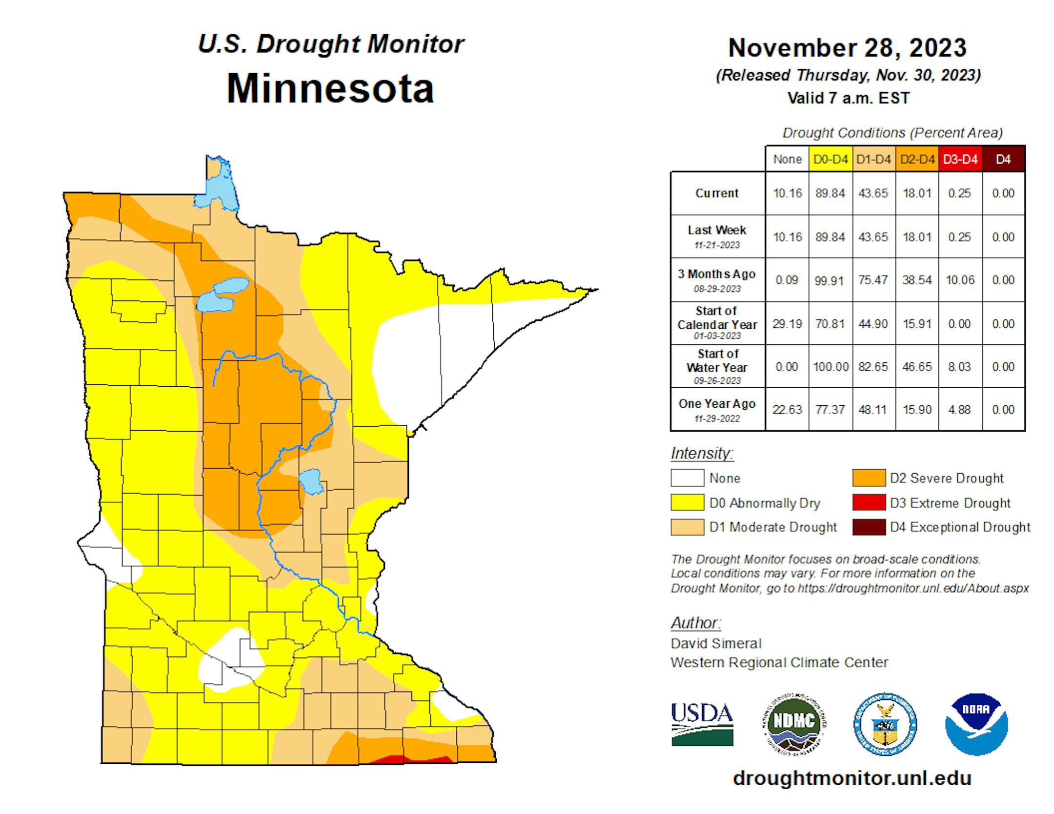
Weather Outlook Through This Weekend (Tropical Tidbits/The Minnesota Star Tribune)

Drought Update

Heavy rains during the month of September have helped the drought situation quite a bit across the state. With that being said, nearly 18% of the state is still in a severe drought, which has improved from 39% nearly 3 months ago.

Minnesota Drought Update (US Drought Monitor/The Minnesota Star Tribune)

Twin Cities Weather Outlook For Tuesday

The weather outlook for the Twin Cities on Tuesday, December 5th will be mostly cloudy with temps warming into the mid/upper 30s, which will be nearly +5F above average for this time of the year.

Advertisement
Advertisement
Twin Cities Weather Outlook For Tuesday (Praedictix/The Minnesota Star Tribune)

Meteograms For Minneapolis

Temperatures in the Twin Cities will start around 30F in the morning and will warm into the mid/upper 30s by the afternoon under mostly cloudy skies. Skies will be mostly cloudy with northwesterly winds around 10mph to 15mph.

Hourly Temps & Sky Conditions For Minneapolis on Tuesday (Praedictix/The Minnesota Star Tribune)
Hourly Wind Gusts & Direction For Minneapolis on Tuesday (Praedictix/The Minnesota Star Tribune)

Weather Outlook For Tuesday

The weather outlook for Tuesday will warm into the 30s across the much of the state, which will be nearly +5F to +10F above average for this time of the year. Note the 40s across the far western part of the Dakotas, this is some of the warmth that will build into Minnesota as we get into the 2nd half of the week.

Weather Outlook For Tuesday (Praedictix/The Minnesota Star Tribune)
Highs From Average on Tuesday (Praedictix/The Minnesota Star Tribune)

Extended Temperature Outlook For Minneapolis

The 5 day temperature outlook for Minneapolis will be warmer than average with readings warming into the mid/upper 30s and 40s through the rest of the week. Temperatures could warm to near 50F by Thursday, which will be nearly +15F to +20F above average for early December.

5 Day Temperature Outlook For Minneapolis (Praedictix/The Minnesota Star Tribune)

Extended Weather Outlook For Minneapolis

The extended weather outlook for Minneapolis through the first full week of December looks very mild with temperatures warming into the 30s and 40s. Incredibly, highs could approach 50F by Thursday. Note that in 139 years of record keeping, the MSP Airport has only hit 50F or warmer in the month of December 84 times. This too is a very rare occurrence, happening less than 2% of December days. After a string of 40s through Friday, temps fall back into the 30s through the weekend and early next week, which will still be above average by nearly +5F.

7 Day Weather Outlook For Minneapolis (Praedictix/The Minnesota Star Tribune)

The Extended Outlook Calls For Warmer Temps

According to NOAA's National Blend of Models, the extended forecast looks very warm through the first part of December. With a lack of snow on the ground, the sun's energy will go into warming the atmosphere, which will be quite efficient this week. With a warmer than average temperature spell moving in, temperatures could warm into the 40s and possibly close to 50F through the week. Enjoy! We're still waiting for the other boot to drop, which it will at some point. Next week doesn't look quite as warm, but highs will still be running above average for this time of the year.

NBM Extended Temperature Outlook For Minneapolis (WeatherBell/The Minnesota Star Tribune)

Weather Outlook

The national weather outlook through the weekend ahead looks a little more unsettled across parts of the nation. Areas of heavy rain and snow will continue in the Northwestern US with up to 5" to 10" of rain possible through Wednesday. By the weekend, a storm system will develop in the Central US with a chance of strong to severe storms in the Southern US on Saturday and areas of snow developing on the northwestern side of the storm.

Advertisement
National Weather Outlook Through The Weekend (Tropical Tidbits/The Minnesota Star Tribune)

8 to 14 Day Temperature Outlook

According to NOAA's Climate Prediction Center, the 8 to 14 day temperature outlook shows warmer than average temperatures continuing across much of the nation and especially in the Midwest.

8 to 14 Day Temperature Outlook (NOAA CPC/The Minnesota Star Tribune)

8 to 14 Day Precipitation Outlook

The 8 to 14 Day Precipitation Outlook shows more active weather across the Western US and Central US. Drier Weather will settled in from the Southwest to the Midwest and across the Eastern US from the 12-18.

8 to 14 Day Precipitation Outlook (NOAA CPC/The Minnesota Star Tribune)

A String of 40s Likely This Week
By Paul Douglas

Newsflash: December is, in theory, on paper, the second snowiest month of the year in the Twin Cities and most of Minnesota. An average of 11.5"of snow falls at MSP during December. January is still the snowiest month with 12.1".

Which is vaguely interesting but not very relevant during an El Nino winter, when most of the storms detour south and east of home. Models increasingly spin up a major snowstorm for Sunday and Monday, with a foot of snow predicted from the Quad Cities to Madison and Milwaukee. So close, and yet so far away. I don't see any (significant) snowfall into next week, when it will be cold enough for snow (highs in the 30s) but moisture will be lacking.

The sun should peek out today and a significant warming trend arrives midweek with more 40s, even an outside shot at 50F close to home Thursday. It should be mild enough for rain showers Friday as cooler air returns.

It's more of a horoscope than weather prediction, but models don't bring (real) snow into Minnesota until January.

Advertisement
Advertisement

Extended Forecast

TUESDAY: Partly sunny and cool. Winds: NW 10-15. High 38.

TUESDAY NIGHT: Clearing skies & chilly. Winds: NW 5. Low: 26.

WEDNESDAY: Mix of clouds and sunshine. quiet. Winds: SW 10-20. High 45.

THURSDAY: What December? Mild sunshine. Winds: SE 8-13. Wake-up: 31. High 50.

FRIDAY: Few rain showers possible, gusty. Winds: W 15-30. Wake-up: 38. High 42.

SATURDAY: Mostly cloudy and cooler. Winds: NW 7-12. Wake-up: 28. High 36.

Advertisement
Advertisement

SUNDAY: Blue sky, colder wind kicks in. Winds: NW 15-25. Wake-up: 24. High 34.

MONDAY: A few flurries, seasonably cool. Winds: NW 15-25. Wake-up: 23. High: 35.

This Day in Weather History

December 5th

1886: Minneapolis hits a record-setting 15 degrees below zero.

Average High/Low for Minneapolis

December 4th

Average High: 33F (Record: 63F set in 2001)

Advertisement

Average Low: 19F (Record: -14F set in 1873)

Record Rainfall: 0.81" set in 1909

Record Snowfall: 7.0" set in 1909

Twin Cities Almanac For December 5th (Praedictix/The Minnesota Star Tribune)

Sunrise/Sunset Times for Minneapolis

December 5th

Sunrise: 7:34am

Sunset: 4:32pm

Advertisement

Hours of Daylight: ~8 hours & 57 minutes

Daylight LOST since yesterday: 1 Minutes & 17 Seconds

Daylight LOST since Summer Solstice (June 21st): ~ 6 Hour & 50 Minutes

Moon Phase for December 5th at Midnight

1.0 Day After Last Quarter Moon

Moon Phase For December 5th at Midnight (The Minnesota Star Tribune)

National High Temps on Tuesday

The weather outlook on Tuesday will be warmer than average across the Western half of the nation with temps running nearly +10F to +20F above average. Areas of heavy precipitation will be found across the Pacific Northwest.

National Weather Outlook For Tuesday (Praedictix/The Minnesota Star Tribune)
National Highs From Average on Tuesday (Praedictix/The Minnesota Star Tribune)

National Weather Outlook For Tuesday

The National Weather Outlook on Tuesday shows areas of light rain/snow drifting through the Ohio Valley with minimal accumulations. A significant push of Pacific moisture will inundate the Pacific Northwest with nearly 5" to 10" of rain rain spots through Wednesday.

Advertisement
National Weather Map For Tuesday (Praedictix/The Minnesota Star Tribune)

National Weather Outlook

The National Weather outlook through Wednesday will be quite unsettled across the Pacific Northwest with heavy rain and a little mountain snow. Some spots could see 5" to 10" of rain through midweek. Meanwhile, a clipper system will move through the Ohio Valley with a little light rain/snow.

National Weather Outlook Through Wednesday (NOAA WPC/The Minnesota Star Tribune)

Extended Precipitation Outlook

The extended precipitation outlook shows heavier precipitation across the Eastern US. The heaviest precipitation will be found in the Northwestern US with several inches of rain and flooding in the coastal communities with high-elevation snow possible.

Extended Precipitation Outlook (NOAA WPC/The Minnesota Star Tribune)

Extended Snowfall Outlook

According to the ECMWF weather model, heavy snows are in the forecast across the high elevations in the Western US. There could be a band of snow across the Central US into the Great Lakes.

ECMWF Extended Snowfall Outlook (WeatherBell/The Minnesota Star Tribune)

Climate Stories

(NOAA/The Minnesota Star Tribune)

"NEW REPORT WARNS OF DRAMATIC RISE IN DEATHS ATTRIBUTED TO ONE CAUSE: 'MAY LEAD TO A 370% INCREASE'"

"A new report by a major medical journal says that the Earth's rising temperatures may lead to a 370% increase in heat-related deaths every year, prompting one program director to suggest that health professionals should be more involved in climate discussions. What happened? As reported by Grist, the Lancet released a study on Nov. 14 warning that our planet's changing temperatures are "threatening the very foundations of human health." Notably, annual heat-related deaths jumped 85% between 2013 and 2022 when comparing them to the statistics from 1991 to 2000, reported Grist. The heat, combined with a significant increase in drought-affected lands, reportedly "put 127 million people at risk of moderate or severe food insecurity," per Grist."

"Extreme Solar Storms May Be More Frequent Than Previously Thought"

"An international team consisting of scientists from nine countries has published a detailed study on a lesser-known solar storm—named Chapman-Silverman event after two astronomers who collected the first data—that hit Earth in February 1872. Their findings confirm that solar storms powerful enough to directly impact our infrastructure are more common than previously thought. Coronal mass ejections or flares are powerful outbursts of charged particles traveling towards Earth. When such a flare hits Earth, it can cause a solar storm disrupting the planet's magnetic field. The largest solar storm recorded so far occurred in 1859 and is known as the Carrington Event. British astronomer Richard Christopher Carrington was the first to observe a gigantic flare on the solar surface. In the following weeks, polar lights were observed during daylight as far as the equator. At the time, long before mobile telecommunications and the widespread use of electronic devices, damage was fortunately very limited."

Advertisement

"NASA's new AI map tool can forecast exactly how climate change will transform your street"

"Did the increase in extreme weather events across the globe in 2023 spike your eco-anxiety? If not, a new artificial intelligence (AI) tool that can predict how climate change could impact your house will. Revealed at COP28, the AI tool, developed by NASA and IBM, will help us monitor Earth from space – measuring environmental changes that have already happened while also making more accurate predictions about the future. While not designed specifically to scare you, the system could help you escape deadly weather events in future. It's a bit like Google Earth – except that you can toggle different algorithms to reveal overlays such as tree cover, carbon emissions, and flooding and wildfire risk. Plus, the developers are making it available to everyone when it becomes available in 2024. This includes nations, corporations, charities – and you."

Thanks for checking in and don't forget to follow me on Twitter @TNelsonWX

@TNelsonWX (The Minnesota Star Tribune)
Advertisement
about the writer

about the writer

Todd Nelson

See Moreicon
Advertisement
Advertisement

To leave a comment, .

Advertisement