Memorial Weekend Outlook

The weather outlook for the Twin Cities this Memorial Weekend Holiday shows warmer and more unsettled weather moving in. It'll feel a bit more humid with chances of showers and thunderstorms, some of which could be strong to severe with locally heavy rainfall.

Saturday Weather Outlook

Temps across the northern half of the state on Saturday will warm into the upper 60s and lower 70s with a few isolated t-showers.

Sunday Weather Outlook

Sunday could be a little cooler across the northern half of the state with a better chance of showers and storms. Some of the storms could be a bit strong later in the day with locally heavy rainfall.

Wednesday Soaker - Warmer & Slightly Unsettled Weekend

Here's the weather outlook from AM Tuesday to PM Monday. Quiet weather continues on Tuesday, but a soaking rain moves through on Wednesday. The next best chance of showers and storms arrives this weekend.

Precipitation Potential Through Next Week

Here's the extended precipitation outlook through next weekend, which shows fairly decent rain amounts across the region coming in 2 different waves. The first will come through midweek and the second will move through late week and during the weekend ahead. Some spots could see 1" to 2" of rain especially across the southeastern part of the state.

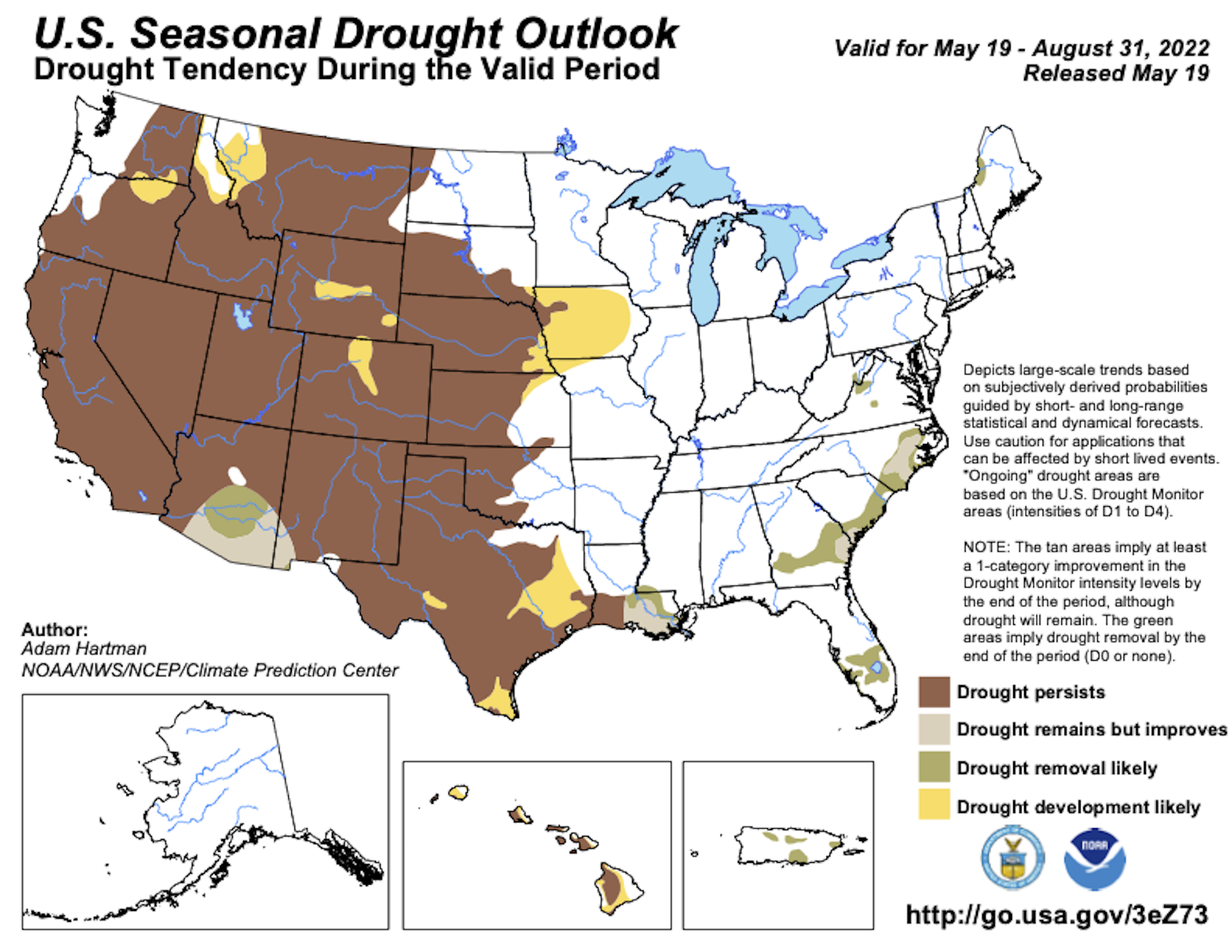
Minnesota Drought Update

Thanks to above average precipitation so far this year, we've wiped out much of the drought that was in place to start the year. In fact, as of early January, nearly 10% of the state in northern Minnesota was considered in a severe drought. Now, only 3% of the state is considered to be abnormally dry.

Status of Spring

"May 18, 2022 - Spring leaf out has now arrived at all but the highest elevation locations in the West. Our spring leaf anomaly compares the arrival of spring leaf out this year to a long-term average of 1991-2020. In the East, spring leaf out is patchy this year, arriving days to weeks late across much of the Southeast and upper Midwest, and arriving days to weeks early across the southern part of the Midwest, the Southern Appalachians, the mid-Atlantic, and the Northeast. In western states, spring leaf out is also patchy, arriving a week late in some locations and over a month early in others. Parts of Montana and South Dakota are 2-3 weeks early. Spring bloom is also spreading north, arriving days to a week late in Texas and Florida and days to several weeks early in California. Spring bloom is over a week early in parts of Georgia, the Carolinas, and Virginia. The mid-Atlantic is patchy, several days early in some locations and several days late in others. The southern part of the Midwest is several days to a week late."

See more from NPN HERE:

Twin Cities Weather Outlook For Tuesday

The weather outlook for Minneapolis on Tuesday looks fairly quiet with a mix of sun and clouds. Temperatures will warm into the mid 60s, which will still be nearly -5F to -10F below average. Clouds will thicken up with chances of showers moving in late in the day.

Meteograms for Minneapolis

The hourly temps for Minneapolis on Tuesday shows temperatures starting in the lower 50s in the morning and warming in mid 60s by the afternoon. Skies will be sunnier in the morning and will be cloudier in the afternoon with showers moving in late in the day. Winds will be southeasterly and could gust close to 15mph.

Weather Outlook on Tuesday

Temps around the region on Tuesday will warm into the 60s which will be nearly -5F to -10F below average across the southern half of the state. Rain will move in from the south late in the day.

Extended Temperature Outlook For Minneapolis

The extended temperature outlook for Minneapolis shows temps running well below average through midweek. Highs later in the week/weekend ahead will be in the upper 70s with more humidity.

Extended Weather Outlook For Minneapolis

The extended weather outlook over the next 7 days shows lingering chilly temps in place over the next few days. Soggier skies will take hold midweek with warmer temps in place by the end of the week and weekend ahead.

Extended Temperature Outlook For Minneapolis

According to the ECMWF & GFS extended temperature outlook, temps will still be chillier than average through midweek. However, temps will warm to above average levels late week and into the Holiday weekend.

8 to 14 Day Temperature Outlook

According to NOAA's Climate Prediction Center, the 8 to 14 day temperature outlook shows above average temps from the Midwest to the Northwest. Meanwhile, folks in the southern and eastern US will be above average.

8 to 14 Day Precipitation Outlook

According to NOAA's Climate Prediction Center, the 8 to 14 Day precipitation outlook shows a better chance of active weather east of the Rockies.

A Lukewarm, Thundery Memorial Day Weekend
By Paul Douglas

When your kids are little they're sweet (most of the time). Then they grow up and find new ways to hurt you. "Hey Dad, we're heading up north this weekend, wondering the best time to be on the lake. Can you check with Ian, Belinda, Chris and Ian?" Appreciate the vote of confidence. It's a little like the news these days - switch the channel and find the forecast you like best.

Holiday weekends always spark malignant feelings of unrequited dread. What can go wrong, and what time? A well-timed warm front arrives with 70s later this week, sparking a few waves of thunderstorms, mainly nighttime hours. Most of the daylight hours will be dry and lukewarm, with a shot at seeing 80s Sunday and Monday if the sun stays out a few hours. No wind chill or heavy jackets, but the atmosphere will be primed for a few heavy thunderstorms every now and then.

In the meantime, clouds increase today with a soaking rain Wednesday, followed by drier skies Thursday and a perfect Friday.

I'm cautiously optimistic for a B+ holiday.

Extended Forecast

TUESDAY: Clouds increase. Winds: SE 10-15. High: 65.

TUESDAY NIGHT: Mostly cloudy, rain likely after midnight. Winds: ESE 5-10. Low: 51.

WEDNESDAY: Rain likely. Maybe an inch. Winds: NE 10-20. Wake-up: 51. High: 55.

THURSDAY: Mostly cloudy, but drier. Winds: NW 10-20. Wake-up: 47. High: 59.

FRIDAY: Sunny and close to perfect. Winds: W 5-10. Wake-up: 45. High: 75.

SATURDAY: Early T-storms, then warm sunshine. Winds: SE 10-15. Wake-up: 56. High: 79.

SUNDAY: Some sun, humid. Few T-storms. Winds: S 10-15. Wake-up: 63. High: 82.

MONDAY: Partly sunny, few pop-up storms. Winds: SE 10-15. Wake-up: 62. High: 81.

This Day in Weather History

May 24th

1925: After seeing a high of 99 degrees two days earlier, the Twin Cities picks up a tenth (.10) of an inch of snow.

1908: Tornadoes hit the counties of Martin and Blue Earth.

Average High/Low for Minneapolis

May 24th

Average High: 72F (Record: 95F set in 2010)

Average Low: 53F (Record: 32F set in 1925)

Record Rainfall: 2.58" set in 2012

Record Snowfall: Trace set in 1924

Sunrise/Sunset Times for Minneapolis

May 24th

Sunrise: 5:35am

Sunset: 8:44pm

Hours of Daylight: ~15 hours & 9 minutes

Daylight GAINED since yesterday: ~ 1 minute & 51 seconds

Daylight GAINED since Winter Solstice (December 21st): ~ 6 Hour & 23 Minutes

Moon Phase for May 24th at Midnight

2.5 Days After Last Quarter Moon

See more from Space.com HERE:

National High Temps Tuesday

The weather outlook on Tuesday shows below average temps across much of the nation. However, temps across the Southwest, including California will be above average with record highs possible.

National Weather Outlook

Here's the national weather outlook through midweek, which shows a fairly large area of low pressure moving up from the Southern US with scattered showers and storms. Some of the storms could be strong to severe with locally heavy rainfall and isolated flooding potential.

Extended Precipitation Outlook

According to NOAA's Weather Prediction Center, areas of heavier precipitation will be found across parts of the central and southern US.

Climate Stories

"Climate Change made devastating early heat in India and Pakistan 30 times more likely"

"Since the beginning of March, India and Pakistan and large parts of South Asia experienced prolonged heat, that at the time of writing, May 2022, still hasn't subsided. March was the hottest in India since records began 122 years ago and in Pakistan, the highest worldwide positive temperature anomaly during March was recorded and many individual weather stations recorded monthly all-time highs through March. At the same time, March was extremely dry, with 62 percent less than normal rainfall reported over Pakistan and 71 percent below normal over India, making the conditions favourable for local heating from the land surface. The heatwave continued over the month of April and reached its preliminary peak towards the end of the month. By the 29th of April, 70 percent of India was affected by the heatwave."

See more from World Weather Attribution HERE:

"A meteor shower outburst from a shattered comet may spawn new tau Herculids display on May 30"

"New for 2022, the tau Herculid meteor shower may make an appearance on the night of May 30-31. Sometimes, astronomy can be full of surprises. Take the case of a tiny comet, normally far too faint to be seen without the help of a telescope. But in 1995, it suddenly and quite unexpectedly brightened up to become dimly visible with the naked eye. Come the end of May, things could turn exciting, thanks again to this same tiny comet. On that night, a new meteor shower — the tau Herculids — might erupt, perhaps ranking with the best of the annual meteor displays. Yet, there is also a small chance of something extraordinary — perhaps one of the most dramatic meteor displays since the spectacular Leonid meteor showers of more than 20 years ago."

See more from Space.com HERE:

"The sun as you've never seen it before"

"Powerful flares, breathtaking views across the solar poles, and a curious solar "hedgehog" are among the haul of spectacular images, movies and data returned by Solar Orbiter from its first close approach to the sun. Although the analysis of the new dataset has only just started, it is already clear that the ESA-led mission is providing the most extraordinary insights into the sun's magnetic behavior and the way this shapes space weather. Solar Orbiter's closest approach to the sun, known as perihelion, took place on 26 March. The spacecraft was inside the orbit of Mercury, at about one-third the distance from the sun to the Earth, and its heatshield was reaching around 500°C. But it dissipated that heat with its innovative technology to keep the spacecraft safe and functioning."

See more from Phys.org HERE:

"Grim 2022 drought outlook for Western US offers warnings for the future as climate change brings a hotter, thirstier atmosphere"

"Much of the western U.S. has been in the grip of an unrelenting drought since early 2020. The dryness has coincided with record-breaking wildfires, intense and long-lasting heat waves, low stream flows and dwindling water supplies in reservoirs that millions of people across the region rely on. Heading into summer, the outlook is pretty grim. The National Weather Service's latest seasonal outlook, issued May 19, 2022, described drought persisting across most of the West and parts of the Great Plains. One driver of the Western drought has been persistent La Niña conditions in the tropical Pacific since the summer of 2020. During La Niña, cooler tropical Pacific waters help nudge the jet stream northward. That tends to bring fewer storms to the southern tier of the U.S. and produce pronounced drought impacts in the Southwest."

See more from The Conversation HERE:

Thanks for checking in and don't forget to follow me on Twitter @TNelsonWX