Much Needed Rain Last Weekend

It has been a pretty soggy over the last few days with as much as 4" to 5" of rain falling in some locations. More than 3" of rain has fallen at the MSP Airport since Saturday, which is the most 3 day rainfall we've seen since June of 2020!

Fall Color Update

Here's a picture from the Cascade River State Park along Minnesota's North Shore. There are lots of color showing up from sugar maples, especially for the inland locations. Peak color isn't far away - book those fall peeping plans now.

Fall Color Update

According to the MN DNR, the fall color season is underway and happening fast. Parts of western and northwestern Minnesota are halfway through the season with peak not far behind. Fall colors will continue to rapidly change, so take a moment and enjoy the season while you can. Note that most leaves will vacate the premises in about 1 month and won't return until sometime in mid/late May...

See more from the MN DNR HERE:

Typical Peak Fall Color

According to the MN DNR, typical peak color arrives across the international border mid to late September with peak color arriving near the Twin Cities late September to mid October. It won't be long now and you'll be able to find your favorite fall color in a backyard near you.

Atlantic Update

According to NOAA's NHC, Tropical Storm Philippe was active in the central Atlantic, which is the 12th named storm of the 2023 season. There is another wave of energy southeast of Philippe that has a high likelihood of formation over the next few days. There is also another tropical wave north of the Yucatan that also has a chance of tropical formation. Stay tuned...

Past Peak of the Atlantic Hurricane Season

The Atlantic hurricane season runs from June 1st to November 30th, but did you know that the typical peak is September 10th? This is when the Atlantic Basin has had the most hurricanes and named storms since records began. This is also when weather conditions are at optimal levels for these types of storms.

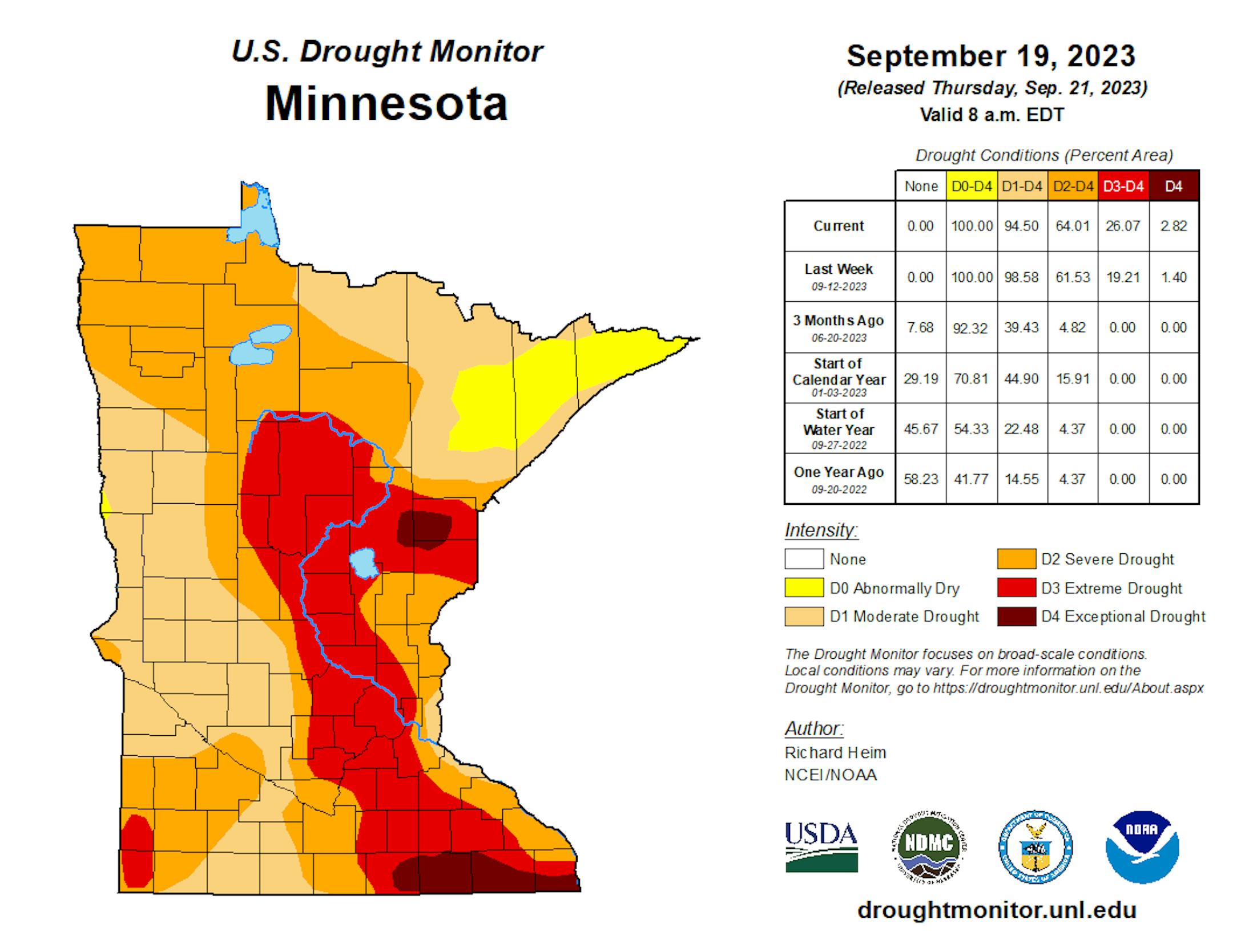
90 Day Precipitation Anomaly

On average, the wettest time of the year is in the summer, with the months of June, July and August seeing nearly 13" of rain at the MSP Airport. If we take a look at the 90 day precipitation anomaly, which dates back to late June, some locations are nearly -3.00" to nearly -7.00" below average (in red/pink). Note that some locations across southeastern Minnesota are nearly -8.00" to -10.00" below average.

Drought Update

Drought continues and expanded across the State. We now have a more expanded Extreme Drought from parts of central Minnesota to southeastern Minnesota. Much of the Twin Cities Metro is now in the Extreme drought as well. Note that nearly 97% of the state is considered to be in drought conditions.

Weather Outlook For Tuesday

The weather outlook on Tuesday looks a little unsettled for some across the southern half of the state. There could be a few isolated showers in the afternoon, but it won't be as soggy as it was over the last few days.

Twin Cities Weather Outlook For Tuesday

The weather outlook for the Twin Cities on Tuesday, September 26th could be a little unsettled with a few spotty showers here and there. The rain showers won't be very heavy and certainly won't be as widespread as they were over the last few days. Temperatures will only warm into the upper 60s, which will be a little below average for this time of the year.

Meteograms For Minneapolis

Weather conditions for Minneapolis on Tuesday will be a little unsettled through the day with isolated showers possible. Temperatures will start around 60F in the morning and will only warm into the mid 60s in the afternoon. East to northeasterly winds will be around 15mph to 20mph.

Extended Temperature Outlook For Minneapolis

The 5 day temperature outlook for Minneapolis shows high temps topping out in the upper 60s and lower 70s through Thursday, which will be pretty close to average for this time of the year. The end of the week and weekend will feature highs in the upper 70s to lower 80s, which will be nearly +10F to +15F above average for the end of September.

Somewhat Humid Weekend, Then Cooling

The max dewpoint forecast for Minneapolis over the next few days shows readings generally hovering in the low/mid 60s, which will feel a little humid for some.

Extended Weather Outlook For Minneapolis

The 7 day extended weather outlook shows lingering light rain showers on Tuesday, but amounts will be pretty minimal. Skies finally dry out on Wednesday with more sunshine later in the week. Highs will approach 80F as we approach the weekend with a slight chance of showers.

A Slight Temperature Bump Next Week

According to NOAA's National Blend of Models, temperatures will be a little closer to average through Thursday. As we approach next weekend, temperatures will warm into the upper 70s to near 80F, which will be nearly +10F to +15F above average for the end of September and early October. We could have a few days in the low/mid 80s through early next week before falling back to near normal temps once again by the first full weekend of October.

Weather Outlook

Weather conditions will slowly improve across the Midwest over the next few days with sunnier and drier skies expected during the 2nd half of the week. A storm system developing in the northwestern part of the nation could send a few more showers our way by next weekend.

8 to 14 Day Temperature Outlook

According to NOAA's Climate Prediction Center, the 8 to 14 day temperature outlook shows Warmer than average temperatures across much of the eastern two-thirds of the nation. Meanwhile, the western US will be cooler than average.

8 to 14 Day Precipitation Outlook

According to NOAA's Climate Prediction Center, more active weather will develop across parts of the western half of the nation and could possibly spill into parts of the Central US, including the Midwest.

Weather Whiplash: From Drought To Flood
By Paul Douglas

Drier droughts. Heavier downpours unleashing more floods. When it does decide to rain it often comes down in buckets. 6.5" of rain just flooded Two Harbors, on Lake Superior's North Shore, with numerous 4-5" amounts over the western metro of the Twin Cities. Weather models were predicting a few 2" amounts. Which makes me wonder out loud if weather models are keeping up with the changes underway.

A warmer climate is flavoring all weather now: more water vapor, more fuel for storms, and a loopier, wavier jet stream that leaves weather systems more prone to stalling for extended periods of time, making droughts longer and drier. And if you happen to be under a stalled "cut-off" low, you may have a very wet basement.

Speaking of warmth, October may kick off with 3 or 4 days of 80s. A warm ridge of high pressure stalling over the central US next week may spark temperatures 20-25F above average.

Clouds linger into midweek with a July rerun this weekend.

I'm kicking myself for taking the boat out too early.

Extended Forecast

TUESDAY: Cloudy and damp. Winds: NE 10-20. High: 65.

TUESDAY NIGHT: Mostly cloudy. Patchy fog. Winds: ENE 5-10. Low: 58.

WEDNESDAY: Gray skies, seasonably cool. Winds: E 8-13. High 68.

THURSDAY: More clouds than sun. Winds: SE 10-20. Wake-up: 60. High 72.

FRIDAY: Sunny with a warm breeze. Winds: SE 10-20. Wake-up: 59. High 80.

SATURDAY: Summer flashback. Warm sun. Winds: S 10-20. Wake-up: 65. High 84.

SUNDAY: Sunny. More July than October. Winds: S 10-20. Wake-up: 66. High: 84.

MONDAY: Autumn heat continues, more sun. Winds: S 10-15. Wake-up: 65. High: 83.

This Day in Weather History

September 26th

1980: Cold morning lows are recorded, with 20 degrees at Tower and 16 at Embarrass.

1942: 1.8 inches of snow falls in St. Cloud.

Average High/Low for Minneapolis

September 26th

Average High: 69F (Record: 87F set in 1923)

Average Low: 50F (Record: 27F set in 1965)

Record Rainfall: 1.81" set in 1930

Record Snowfall: 1.7" set in 1942

Sunrise/Sunset Times for Minneapolis

September 26th

Sunrise: 7:04am

Sunset: 7:03pm

Hours of Daylight: ~11 hours & 58 minutes

Daylight LOST since yesterday: 3 Minutes & 6 Seconds

Daylight LOST since Summer Solstice (June 21st): ~ 3 Hour & 39 Minutes

Moon Phase for September 26th at Midnight

2.1 Days Before Full "Harvest" Moon -

Friday, Sept. 29 at 4:58 a.m. CDT - Traditionally, this designation goes to the full moon that occurs closest to the Autumnal (Fall) Equinox. In most years, the Harvest Moon comes in September, but about every four or five years it occurs in October (next time this will happen will be in 2025). At the peak of the harvest, farmers can work into the night by the light of this moon. Usually, the full moon rises an average of 50 minutes later each night, but for the few nights around the Harvest Moon, the moon seems to rise at nearly the same time each night: just 25 to 30 minutes later across the U.S., and only 10 to 20 minutes later for much of Canada and Europe. Corn, pumpkins, squash, beans, and wild rice — the chief Native American staples — are now ready for gathering."

See more from Space.com HERE:

National High Temps on Tuesday

Temperatures on Tuesday will be warmer than average across the Southern US with highs warming into the 90s and 100s for some. These readings will be nearly +5F to +10F above average for this time of the year. Lingering cool weather will be found in the Northeast with highs only warming into the 60s, which will be nearly -10F to -15F below average.

National Weather Tuesday

The weather outlook on Tuesday looks unsettled from parts of the Ohio Valley to the Gulf Coast. A few storms could be strong to severe with locally heavy rainfall. There will also be some heavier precipitation in the Pacific Northwest as a large storm system sits offshore.

National Weather Outlook

The weather outlook through Wednesday shows lingering showers and thunderstorms from the Great Lakes and Ohio Valley with locally heavy pockets of rain. There will also be some heavier precipitation in the Pacific Northwest.

Extended Precipitation Outlook

The extended precipitation outlook shows areas of heavy rainfall across the Pacific Northwest and the High Plains. Decent rain tallies will be possible in the Ohio Valley and certainly across Florida.

Climate Stories

"Smart thermostats are helping Arizona's grid ride out extreme heat"

"Amid soaring temperatures, Arizona has seen success with utility programs that incentivize people to turn down the AC when the power grid is stressed. In Arizona, utilities have used a counterintuitive tool to help keep the lights on despite the state's ongoing wave of historic heat — they've asked customers to turn their air conditioners down. In July and August, Arizona's three biggest utilities were able to call on more than 100,000 customers to reduce their electricity use by a total of 276 megawatts during afternoon and evening hours when demand for power was at its peak. For most of those same months, the southern Arizona territories served by those utilities were in the midst of a record-setting stretch of consecutive days over 110 degrees Fahrenheit."

See more from Grist HERE:

"A Record Number of Billion-Dollar Disasters Show U.S. Isn't Ready for Climate Change"

"By the end of this August, the U.S. had already set a new record for the annual number of billion-dollar disasters, which continues a trend toward more and costlier calamities occurring since the National Oceanic and Atmospheric Administration began tracking such data in the 1980s. At that time, a disaster causing at least $1 billion in damage hit the U.S. about every three months; now they happen about every three weeks, says Adam Smith, a NOAA climatologist who helps track the data. And the costs of such disasters are almost certainly underestimates, underscoring how far behind the U.S. is in preventing and preparing for disasters at a time when climate change is exacerbating many of them. "It's not a sustainable situation," Smith says."

See more from Scientific American HERE:

"This floating wind turbine is designed to pop up in the open ocean"

"Last May, inside a sprawling building in the Netherlands, a team from a California-based startup stood next to a deep indoor pool and waited for a wave machine to be turned on, simulating the open ocean. Then they watched as a 10-foot-long scale model of their wind turbine was towed into the water. At first, the tower floated flat on its side. Then, as ballasts at its base filled with water, it pulled itself upright. The pop-up device, from a company called Aikido Technologies, is designed to make it easier for offshore wind energy to be deployed quickly. The company is focused on floating wind turbines because they can fill an important gap: As offshore wind energy grows, there are some places where traditional turbines can't easily be installed. There are strong winds off the coast of California, for example, but the water is so deep that it doesn't make sense to attach a turbine to the seafloor. Floating wind farms could make it possible to capture wind power there and in many other places, from Maine to the Gulf of Mexico to Hawaii."

See more from Fast Company HERE:

Thanks for checking in and don't forget to follow me on Twitter @TNelsonWX