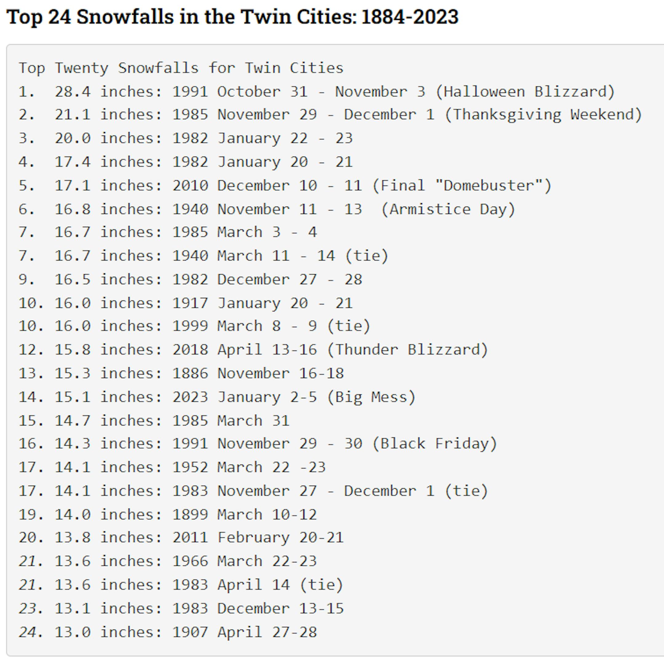
Top 20 + Snowfalls in the Twin Cities: 1884-2023

Below, we have listed the 24 largest snowfall events on record in the Twin Cities, using data back to 1884. To qualify, any snowfall total must have been caused by the same weather system—for instance a surface cyclone (or "low-pressure system"). If the snow stops, but the same feature is influencing the weather, and the snow starts up again, that's all one event. If the snow falls on one day because of one system, then takes a short break and falls again the next day because of a different system, that would be two events. Duration About a quarter of these snowstorms occurred either during one observation day or within a 24-hour period that overlapped two observation days. The remainder extended for over 24 hours, and 10 of the entries covered three or more calendar days. During multi-day snowstorms, it is common to find multiple waves or "phases" of accumulating snow, as surges of moisture and energy rotate around the parent weather system.

See more from the Climate Office HERE:

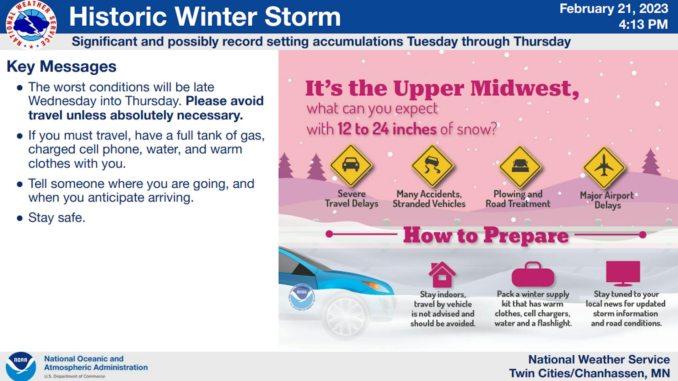
MAJOR WINTER STORM TUESDAY THROUGH THURSDAY

HISTORIC WINTER STORM SHOULD LEAD TO IMPOSSIBLE TRAVEL BY WEDNESDAY NIGHT AND EARLY THURSDAY

Two primary rounds of snow are expected. The first will occur this afternoon through tonight, moving from west to east. Accumulations of 4 to 8 inches are expected with round one. Round two is more widespread, and will begin Wednesday afternoon and continue into Thursday with an additional 8 to 18 inches expected. Total snow accumulations will range from 14 to 24 inches, with the best chance for the higher end totals along a west to east axis from west central Minnesota through east central Minnesota and into west central Wisconsin. This is expected to reach the top 5 heaviest snow storms for many location. The worst conditions will be Wednesday afternoon through Thursday morning, and a Blizzard Warning is in effect for many counties in western and central Minnesota during this time frame. Heavy snow will combine with northeast wind gusts of 35 mph across the region, to around 45 mph in western and central Minnesota. This will lead to significant blowing and drifting snow with whiteout conditions in open areas. Some drifts may be several feet deep, making travel nearly impossible.

WINTER STORM WARNING REMAINS IN EFFECT UNTIL 6 PM CST THURSDAY

WHAT...Heavy snow expected. Total snow accumulations of 16 to 21 inches. Winds gusting as high as 40 mph.

WHERE...Portions of central, east central, south central and southeast Minnesota and west central Wisconsin.

WHEN...Until 6 PM CST Thursday.

IMPACTS...Travel could be very difficult to impossible. Patchy blowing snow could significantly reduce visibility. The hazardous conditions could impact the morning or evening commute.

Major Winter Storm PM Tuesday - Thursday

This will be an extremely busy forecast period as a major winter storm unfolds across the region PM Tuesday - Thursday. Heavy snow and strong winds could cause major issues across much of the region. The worst of the storm moves in PM Wednesday through Thursday. Driving could be near impossible across the region as this 2nd wave moves through.

Snowfall Potential

Snowfall tallies across much of central and southern Minnesota will be quite impressive to say the least. It appears that widespread 10" to 20" amounts will be likely, including the Twin Cities metro. This could be the biggest storm that the metro has seen since December 2010.

Winter Storm Severity Index

According to NOAA, this storm will likely have major to extreme impacts across much of the southern half of the state, including the Twin Cities metro. Take this storm seriously.

Round #1 Snow

This first round will drop anywhere from 4" to 8" of snow from PM Tuesday to AM Wednesday along and south of the I-94 corridor. This will be the "lighter" round of snow, but will be capable of travel disruptions. If you can, try to get this first of snow cleared before the next round moves in Wednesday and Thursday.

Round #2 Snow

The 2nd round of snow will develop Wednesday through Thursday. This will be the heaviest snow with the most wind and it will be the most impactful. Additional 10" to 15" amounts (or more) will be likely. This could be a life-threatening event, so take this one seriously.

Extreme Winds

Strong wind gusts in excess of 40mph will create widespread blowing snow and white-out conditions. This will create very dangerous travel conditions, while will be near impossible and possibly life-threatening.

Extended Temperature Outlook

The NBM extended temperature outlook for Minneapolis over the next several days shows cooler weather now in place through the rest of the week. This will allow the snow to become lighter and fluffier, meaning that blowing and drifting snow will be a big issue. It looks like we'll see a gradual warming trend as we head through the weekend and into next week. The last few days of February will be warmer with temps in the 30s

Snow Depth

As of Monday, February 20th, the MSP Airport still had 4" of snow on the ground, which is much lower than it was before last Tuesday's rain. There is still nearly 1ft to 2ft of snow across parts of northern Minnesota, Wisconsin and the UP of Michigan.

Seasonal Snowfall

Taking a look at snowfall since July 1st, many locations have seen above average amounts so far this season, but folks from near Sioux Falls to the Twin Cities and towards Duluth are nearly 15" to 25" above average this month. 57.3" of snow has fallen at the MSP Airport, which is the 10th snowiest start to any season on record.

Twin Cities Weather Outlook For Wednesday

The weather outlook for the Twin Cities on Wednesday, February 21st will be quite active with areas of snow moving through the region. We may wake up to light snow falling before a brief lull midday and then heavy snow redeveloping in the afternoon/evening. It'll feel much colder thanks to stronger winds with feels like temps in the single digits much of the day.

Weather Outlook on Wednesday

Temps across the region on Wednesday will be nearly -10F to -25F cooler than average with readings only warming into the 10s and 20s across much of the state. Some locations in the northwestern corner of the state will only warm into the single digits above and below zero.

Meteograms For Minneapolis

The weather outlook for the Twin Cities through the day Wednesday shows temps hovering in the upper 10s to low/mid 20s. Areas of snow will continue in the morning with lighter snow possible midday. The heavier batch of snow redevelops mid/late afternoon with heavy accumulations possible. Winds will be quite strong through the day with some 30mph to 40mph, which will create blowing and drifting and possible white-out conditions in open areas.

Hourly Feels Like Temps

Feels like temps on Wednesday will be quite cold with readings hovering in the single digits all day. Strong winds and areas of heavy snow late in the day will be make it quite raw tomorrow.

Weather Outlook

Weather conditions will be very active in the Central US through Thursday. Areas of heavy snow and blizzard conditions will be possible up north with strong to severe thunderstorms possible farther south.

Extended Temperature Outlook For Minneapolis

This major winter storm will continue to unfold across the Midwest through the week as temperatures dip to well below average levels. It'll get quite cold late week with a gradual warming trend this weekend.

Extended Weather Outlook For Minneapolis

Weather conditions through Thursday will be quite active with areas of heavy snow and wind. It'll be quite disruptive if you do have to venture out, so don't if you don't have to. It'll get much better this weekend with drier, quieter and milder weather.

8 to 14 Day Temperature Outlook

According to NOAA's Climate Prediction Center, the 8 to 14 day temperature outlook shows cooler than average temperatures lingering across the Western US. Meanwhile, the Southern US will warm to above average levels.

8 to 14 Day Precipitation Outlook

According to NOAA's Climate Prediction Center, the 8 to 14 Day precipitation outlook shows more active weather in place across much the Western US and across the Midwest/Great Lakes.

Top 5 MSP Snowstorm Still Possible
By Paul Douglas

Old Man Winter is hyping the weather again Irma! Will it be "Oh those meteorologists are just talking it up for ratings!" or "Why didn't we get more warning?" Believe it or not, we're just trying to get it right, and set appropriate expectations for what still appears to be an historic storm. I'm not expecting 2 feet of powder but if totals go over 17.1" it will be a Top 5 Twin Cities Snowstorm (since 1884). That isa still a distinct possibility.

We talked about significant snow potential last week at this time, and since then weather models have been remarkably consistent, from run to run and model to model. A cold, long-duration snowfall, fueled by ample moisture from the Gulf of Mexico.

Snow gets heavier this evening with another 10-14" before tapering by the dinner hour Thursday.

A blizzard? Yes. Winds gust over 40mph with white-out conditions. I wouldn't risk driving tomorrow. Nope.

Winds ease Friday, giving MnDOT a chance to dig out. 30s return by Sunday. An 80"+ winter at MSP? Sure looks like it.

Extended Forecast

WEDNESDAY: Snow gets heavier late PM. Winds: NE 20-40. High: 24.

WEDNESDAY NIGHT: Snow likely. Winds: ENE 5-15. Low: 15.

THURSDAY: Blizzard likely. Another 10-15" snow. Winds: NE 20-40. High: 18.

FRIDAY: Storm totals: 12-20". Light winds. Winds: SE 3-8. Wake-up: -3. High: 8.

SATURDAY: Partly sunny and quiet. Winds: SW 8-13. Wake-up: 3. High: 23.

SUNDAY: Mix of clouds and sun, thawing out. Winds: SE 7-12. Wake-up: 8. High: 36.

MONDAY: Say what? Periods of rain possible. Winds: NW 10-20. Wake-up: 32. High: 38.

TUESDAY: Partly sunny and brisk. Winds: NW 15-25. Wake-up: 22. High: 30.

This Day in Weather History

February 22nd

1922: A blizzard, ice storm and thunderstorms all occur on the same day across Minnesota. Winds hit 50 mph in Duluth while thunderstorms were reported in the Twin Cities. Heavy ice over southeast Minnesota with 2 inches of ice on wires near Winona. Over two inches of precipitation fell. This was also one of the largest ice storms ever in Wisconsin history with ice four inches in diameter on telegraph wires. One foot of ice covered wire weighed 11 pounds. One killed and four injured in Wisconsin.

Average High/Low for Minneapolis

February 22nd

Average High: 31F (Record: 59F set in 2017)

Average Low: 15F (Record: -22F set in 1873)

Record Rainfall: 1.13" set in 1922

Record Snowfall: 8.8" set in 1913

Sunrise/Sunset Times for Minneapolis

February 22nd

Sunrise: 7:02am

Sunset: 5:50pm

Hours of Daylight: ~10 hours & 48 minutes

Daylight GAINED since yesterday: +3 Minutes & 01 Seconds

Daylight GAINED since Winter Solstice (December 21st): ~ 2 hour & 10 minutes

Moon Phase for February 22nd at Midnight

3.0 Day Since New Moon

National High Temps on Wednesday

Temperatures on Wednesday will be very mild warm much of the southern and southeastern US with readings nearly +10F to +25F above average for many locations. Note that widespread record warmth will be likely in the Southern/Southeastern US several days here through the end of the month.

Record Warmth Wednesday

There will be record warmth across the Southeastern US from Kentucky to Florida. The record warmth will likely stick around for some through the weekend.

National Weather Outlook Wednesday

The weather outlook for Wednesday shows much more active weather in place across the Central US. Widespread heavy snowfall will be found across the northern half of the nation, while strong to severe storms will develop in the Southern US.

National Weather Outlook

A very large and impactful storm system will take shape in the Central US through the end of the week with widespread and heavy snowfall across parts of the Western US and Midwest. Strong winds could blizzard conditions across a wide area.

Extended Precipitation Outlook

According to NOAA's Weather Prediction Center, the extended precipitation outlook shows heavier amounts across the Western US and especially in the high elevations. We'll also see areas of heavier precipitation in the Central US, where strong to severe thunderstorms will be possible along with heavy snow.

Snowfall Potential

According to the ECMWF (European model), heavy snow will be found across much of the high elevations in the Western US. Parts of the Midwest and Great Lakes will be dealing with heavy snow this week.

Climate Stories

"Why Is the Amazon So Important for Climate Change?"

"Here's why the Amazon rain forest is key to protecting Earth from the detrimental effects of climate change. Viewed from high above, the Amazon in South America is a lush emerald quilt, home to millions of animals and the planet's largest river by volume. It is also key to protecting our planet from the detrimental effects of climate change. But why? And what could happen to the global climate if we lost it? The Amazon's sheer size—it covers nearly seven million square kilometers, or about the area of Australia—makes it shine on the climate stage. With so many trees covering such an enormous swath of land, everything the forest "does" is big and impactful. Some of its actions are downright unique: The Amazon makes its own weather, generating some of its rainfall and keeping itself cool, while also stabilizing regional temperatures. Add that to the gobs of greenhouse gas that its biomass stores and you've got a natural climate protector. Yet we are steadily dismantling this valuable landscape, aggravating climate change in several ways scientists are just beginning to understand."

See more from Scientific American HERE:

"Every Coastal Home Is Now a Stick of Dynamite"

The Langfords got out of Houston just in time. Only two months after Sara and her husband, Phillip, moved to Norfolk, Virginia, in June 2017, Hurricane Harvey struck, destroying their previous house and rendering Sara's family homeless. By comparison, Norfolk felt like paradise. In Larchmont, the neighborhood the Langfords fell in love with, young children scratched chalk doodles on the sidewalks, college students and senior citizens ran side by side on nature trails, and crepe myrtle trees popped pink along silent streets.

See more from The Atlantic HERE:

"What are the effects of global warming?"

"The effects of global warming can be seen and felt across the planet. Global warming, the gradual heating of Earth's surface, oceans and atmosphere, is caused by human activity, primarily the burning of fossil fuels that pump carbon dioxide (CO2), methane and other greenhouse gases into the atmosphere. Already, the consequences of global warming are measurable and visible." We can observe this happening in real time in many places," Josef Werne, a professor of geology and environmental science at the University of Pittsburgh, told Live Science. "Ice is melting in both polar ice caps and mountain glaciers. Lakes around the world, including Lake Superior, are warming rapidly — in some cases faster than the surrounding environment. Animals are changing migration patterns and plants are changing the dates of activity," such as trees budding their leaves earlier in the spring and dropping them later in the fall."

See more from Live Science HERE:

Thanks for checking in and don't forget to follow me on Twitter @TNelsonWX