Autumnal Equinox - First Day of Fall!

Saturday, September 23rd at 1:50 AM CDT - "There are two equinoxes every year: one in September and one in March. In September, the Sun crosses the equator from north to south. The September equinox is the moment the Sun crosses the celestial equator—an imaginary line in the sky above Earth's equator—from north to south. This happens on September 22, 23, or 24 in most years. Why Is It Called "Equinox?" On the days of the equinoxes, the Earth's axis is perpendicular to the Sun's rays, meaning that all regions on Earth receive about the same number of hours of sunlight. In other words, night and day are, in principle, the same length all over the world. This is the reason it's called an "equinox," derived from Latin, meaning "equal night." However, this is literal translation not entirely true. In reality, equinox days don't have exactly 12 hours of daylight and 12 hours of dark."

See more from Time & Date HERE:

Soggy First Weekend of Fall

A slow-moving storm system will be responsible for shower and thunderstorm chances as we head into our first weekend of Fall. Some of the storms PM Saturday could be strong to severe with locally heavy rainfall. Showers will linger into early Sunday with cooler temperatures.

Simulated Radar

Here's the simulated radar from AM Friday to Saturday night. The center of circulation will be situated over the Dakotas and will be the feature responsible for the widespread showers and storms across much of the region. Multiple waves of rain will be possible over the next few days and some spots could see 1" to 2" of rain or more through Sunday. Note that some of the storms could be strong to severe as well.

Severe Threat Saturday

According to NOAA's Storm Prediction Center, there is a Marginal Risk of severe weather across the southern half of the state, including the Twin Cities. The far southwest corner of the state is under a Slight Risk, which is a level 2 out of 5 on the severe scale. Within both of these severe risk areas, large hail, damaging winds and an isolated tornado will be possible along with locally heavy rainfall.

Rainfall Potential Through The Weekend

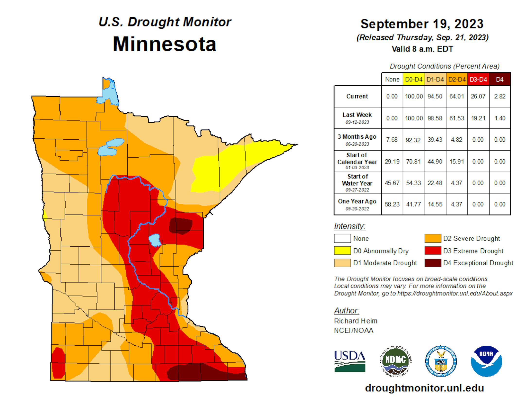
According to NOAA's Weather Prediction Center, there could be some 1" to 2" rainfall tallies across parts of Western and Southwestern Minnesota. Much of the state is well below average precipitation, so it would be nice to get a good soaking.
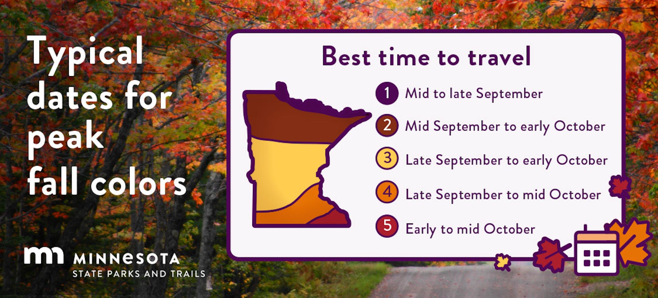
Fall Color Update

Here's a picture from the Lutsen Mountain webcam from earlier Thursday. Lots of color showing up from sugar maples along the North Shore. Peak color isn't far away - book those fall peeping plans now!

See more from Lutsen Mountain HERE:

Fall Color Update

According to the MN DNR, the fall color season is underway and happening fast. Parts of western and northwestern Minnesota are halfway through the season with peak not far behind. Fall colors will continue to rapidly change, so take a moment and enjoy the season while you can. Note that most leaves will vacate the premises in about 1 month and won't return until sometime in mid/late May...

Typical Peak Fall Color

According to the MN DNR, typical peak color arrives across the international border mid to late September with peak color arriving near the Twin Cities late September to mid October. It won't be long now and you'll be able to find your favorite fall color in a backyard near you.

Ophelia Develops in the Atlantic

Tropical Storm Ophelia developed in the Atlantic on Friday and becomes the 11th named storm of the 2023 Atlantic Hurricane Season. Here's some information from Phil Klotzbach on Twitter: "Tropical Storm #Ophelia has formed off of the North Carolina coast - the 11th Atlantic named storm to form since August 20. The only season with more Atlantic named storm formations between August 20 - September 22 is 2020 (12 formations). #hurricane"

Tropical Storm Ophelia

According to NOAA's NHC - Ophelia makes landfall along the North Carolina coast early Saturday morning and will drift north through the Mid-Atlantic states through the weekend and early next week. Tropical Storm Warnings have been posted for the likelihood of strong winds, storm surge and very heavy rainfall. There could even been some isolated tornadoes and Ophelia moves inland.

Storm Surge Forecast

According to NOAA's NHC, there could be up to a 5ft storm surge along the North Carolina and Virginia Coast. Inland flooding is likely in some of these areas along with dangerous rip currents.

Heavy Rainfall

The rainfall forecast through Monday evening shows fairly widespread heavy amounts from the Mid-Atlantic coast to the New England coast. Some of the heaviest tallies could exceed 6" in North Carolina with flooding likely.

Past Peak of the Atlantic Hurricane Season

The Atlantic hurricane season runs from June 1st to November 30th, but did you know that the typical peak is September 10th? This is when the Atlantic Basin has had the most hurricanes and named storms since records began. This is also when weather conditions are at optimal levels for these types of storms.

90 Day Precipitation Anomaly

On average, the wettest time of the year is in the summer, with the months of June, July and August seeing nearly 13" of rain at the MSP Airport. If we take a look at the 90 day precipitation anomaly, which dates back to early to mid June, some locations are nearly -3.00" to nearly -7.00" below average (in red/pink). Note that some locations across southeastern Minnesota are nearly -8.00" to -10.00" below average.

Drought Update

Drought continues and expanded across the State. We now have a more expanded Extreme Drought from parts of central Minnesota to southeastern Minnesota. Much of the Twin Cities Metro is now in the Extreme drought as well. Note that nearly 97% of the state is considered to be in drought conditions.

Weather Outlook For Saturday

The weather outlook on Saturday will be pretty unsettled with round of showers and storms likely across the state. Some of the storms could be strong to severe with locally heavy rainfall. Temperatures will warm into the 60s and 70s, which will be a little above average for this time of the year.

Twin Cities Weather Outlook For Saturday

The weather outlook for the Twin Cities on Saturday, September 23rd will be fairly unsettled through the day. We could see waves of showers and storms, some of which could be strong to severe with locally heavy rainfall.

Meteograms For Minneapolis

Weather conditions for Minneapolis on Saturday will be unsettled through the day with scattered showers and storms. Temps will start in the mid 60s and will warm into the mid 70s by the afternoon. The best chance of strong to severe storms and locally heavy rainfall will be later in the day. Note that southeasterly winds will become quite strong through the day with gusts approaching 35mph to 40mph in the afternoon and evening.

Extended Temperature Outlook For Minneapolis

The 5 day temperature outlook for Minneapolis shows mild temperatures continuing and Saturday with highs in the mid/upper 70s, which will be nearly +5F to +10F above average for this time of the year. Readings dip into the 60s on Sunday, which will be a few degrees below average, but we'll level out into the low/mid 70s early next week.

Somewhat Humid Weekend, Then Cooling

The max dewpoint forecast for Minneapolis looks a little humid on Saturday with readings in the mid 60s ahead of strong thunderstorm potential. It'll get more comfortable as we head into next week with readings falling into the 50s once again.

Extended Weather Outlook For Minneapolis

The 7 day extended weather outlook shows more unsettled weather in place through the weekend with rounds of showers and storms. The heaviest rainfall will be in place through early Sunday with lingering light showers possible Sunday into Monday. Skies dry out after Monday with temps hovering in the mid 70s through the rest of the week.

A Slight Temperature Bump Next Week

According to NOAA's National Blend of Models, temperatures will warm to above average levels again on Saturday and will cool a bit on Sunday. The extended forecast through the last full week of September look pretty comfortable with highs hanging on in the mid 70s.

Weather Outlook

The weather outlook in the Midwest through the weekend looks a bit unsettled with scattered showers and storms and lingering rain through Monday. Some spots could see heavy rainfall before we clear out and dry out into our last full week of September. Another storm system looks to develop across the High Plains next week, but a majority of that rain looks to stay west of us for now.

8 to 14 Day Temperature Outlook

According to NOAA's Climate Prediction Center, the 8 to 14 day temperature outlook shows Warmer than average temperatures across much of the eastern two-thirds of the nation. Meanwhile, the western US will be cooler than average.

8 to 14 Day Precipitation Outlook

According to NOAA's Climate Prediction Center, more active weather will develop across parts of the western half of the nation and could possibly spill into parts of the Midwest. Meanwhile, it'll be drier east of the Mississippi River.

Stop The Presses: It May Actually Rain
By Paul Douglas

I like my eggs scrambled, not my seasons. There is something wonderfully-weird about gazing up at ripening fall foliage decked out in shorts and flip flops.

Summer isn't on an on-off switch. It's more of a dimmer switch, and symptoms of the hottest summer on record across the Northern Hemisphere will spill deep into autumn, in fact a few models hint at 80s as we crunch our way into early October. I appreciate a super-sized summer, but this is all a bit bewildering.

In the meantime, those same weather models are trending wetter this weekend, with a better chance of some 1" rainfall amounts around the metro; maybe 2" for parts of Minnesota. That may well put a dent in the drought, but it will take a conga-line of very wet storms for drought to end. My sense is that drought will linger into winter, with a continued mild bias into early 2024. NOAA's climate models confirm that. Thank you El Nino?

A few T-storms may be severe south/west of MSP later today but skies dry out by Sunday PM. Let it rain!

Extended Forecast

SATURDAY: Heavy showers, T-storms. Winds: SE 15-35. High 74.

SATURDAY NIGHT: Windy. Showers and storms likely. Winds: ESE 10. Low: 61.

SUNDAY: Showers taper, drier PM hours. Winds: SE 15-25. High: 73.

MONDAY: A few showers linger. Winds: S 8-13. Wake-up: 59. High: 71.

TUESDAY: Sun breaks through, a dry day. Winds: E 8-13. Wake-up: 56. High: 74.

WEDNESDAY: Sunny and pleasant. Winds: SE 8-13. Wake-up: 54. High 70.

THURSDAY: Mix of clouds and sun, breezy. Winds: SE 10-20. Wake-up: 55. High 72.

FRIDAY: Sunny and warmer. Winds: S 10-20. Wake-up: 56. High 76.

This Day in Weather History

September 23rd

1995: 0.2 inches of snow falls in the St. Cloud area.

1985: Early snow falls over portions of Minnesota and western Wisconsin. Just under a half inch (0.4) is recorded at MSP Airport, mostly during the afternoon.

1937: From summer to winter. The temperature was 101 at Wheaton. Then a cold front came through causing the mercury to tumble below freezing.

Average High/Low for Minneapolis

September 23rd

Average High: 70F (Record: 90F set in 1891, 1937 & 2017)

Average Low: 51F (Record: 30F set in 1983)

Record Rainfall: 1.98" set in 2010

Record Snowfall: Trace set in 1928, 1942 & 1995

Sunrise/Sunset Times for Minneapolis

September 23rd

Sunrise: 7:01am

Sunset: 7:09pm

Hours of Daylight: ~12 hours & 8 minutes

Daylight LOST since yesterday: 3 Minutes & 6 Seconds

Daylight LOST since Summer Solstice (June 21st): ~ 3 Hour & 29 Minutes

Moon Phase for September 23rd at Midnight

1.5 Days Before First Quarter Moon

National High Temps on Saturday

Temperatures on Saturday will be fairly mild across the middle part of the country with temps warming into the 80s and 90s, which will be above average for this time of the year. Folks along the East Coast will be cooler than average as Ophelia moves in. The Western US will also be cooler than average with areas of rain and thunder possible.

National Weather Saturday

The weather outlook on Saturday looks more unsettled across the Central US with widely scattered showers and storms, some of which will be strong to severe with locally heavy rainfall. The East Coast will be dealing with Ophelia, so gusty winds and heavy rainfall will be possible there as well.

National Weather Outlook

The weather outlook through Monday shows Ophelia lifting through the Mid-Atlantic and Northeast with strong winds and heavy rainfall. There will also be scattered storms in the Central US with a severe threat and heavy rainfall.

Extended Precipitation Outlook

The extended precipitation outlook shows areas of heavy rainfall across the Northeast as Ophelia pushes through. The Central US will see heavy rainfall in spots with strong to severe storms possible. There will also be a pretty significant surge of Pacific precipitation in the Northwest with some high elevation snow.

Climate Stories

"It's Not Your Imagination, Air Turbulence Is Getting Worse—Here's Why"

"Flights are getting bumpier, and experts say they know what's to blame. Fasten your seatbelts—here's why air turbulence incidents are increasing. We're in for a bumpy ride. If you've noticed an increase in turbulence during air travel lately, you're not wrong. A recent study has shown that turbulence—the kind that makes for a bumpy and potentially scary flight—is getting worse. The 2023 study from the American Geophysical Union analyzed clear-air turbulence (CAT) trends globally, finding increases at certain aircraft cruising altitudes. The study also projected CAT to intensify in response to future climate change—one more reason to keep your seat upright and stay buckled-in when flying. We asked two aviation experts to explain the physics of air turbulence, why it's getting worse and how dangerous it really is for commercial aircraft and its passengers."

See more from RD HERE:

"FEMA Needs More Money to Keep Up with Disasters. Instead It Faces a Potential Government Shutdown"

"The head of the Federal Emergency Management Agency warned Tuesday that a government shutdown would jeopardize FEMA's ability to help people after disasters during the peak of hurricane season. FEMA imposed emergency spending restrictions three weeks ago as its disaster fund dwindled to dangerously low levels. The Biden administration is asking Congress for $16 billion in emergency cash for the fund and an additional $20 billion for the fiscal year beginning Oct. 1. But with both requests in doubt, the little money that's left in the disaster fund "would be insufficient to cover all of our ongoing life-saving operations," FEMA Administrator Deanne Criswell told members of a House Transportation and Infrastructure subcommittee."

See more from Scientific American HERE:

"Long-Lasting La Niña Events More Common Over Past Century"

"Multiyear La Niña events have become more common over the last 100 years, according to a new study led by University of Hawai'i (UH) at Mānoa atmospheric scientist Bin Wang. Five out of six La Niña events since 1998 have lasted more than one year, including an unprecedented triple-year event. The study was published this week in Nature Climate Change. "The clustering of multiyear La Niña events is phenomenal given that only ten such events have occurred since 1920," said Wang, emeritus professor of atmospheric sciences in the UH Mānoa School of Ocean and Earth Science and Technology. El Niño and La Niña, the warm and cool phases of a recurring climate pattern across the tropical Pacific, affect weather and ocean conditions, which can, in turn, influence the marine environment and fishing industry in Hawai'i and throughout the Pacific Ocean. Long-lasting La Niñas could cause persistent climate extremes and devastating weather events, affecting community resilience, tourist industry and agriculture."

See more from Eurasia Review HERE:

Thanks for checking in and don't forget to follow me on Twitter @TNelsonWX