Labor Day Weekend Forecast

It'll be an extremely hot weekend with record heat possible on Sunday and Monday across many communities. After a few morning rain showers on Saturday, hot and steamy sunshine develops Saturday with highs approaching the mid 90s in the afternoon and not too far away from the record of 97F set in 1937. If the current forecast holds, 100F on Sunday would be the 2nd time the Twin Cities has ever warmed into the 100s for the month of September. We could see another record high on Labor day Monday with readings back in the upper 90s.

Record Heat This Labor Day Weekend

Saturday will be well above average across the region with highs warming into the low/mid 90s. Record heat will develop southwest of the Twin Cities with readings approaching the century mark across South Dakota. A record of 99F will be possible in Sioux Falls, SD on Saturday and will be one of many records expected into the weekend.

Record Heat on Sunday

Widespread records will be found on Sunday with highs warming into the 90s and possibly up to 100F across parts of the Midwest, including the Twin Cities. Again, if we hit 100F it will only the 2nd time we've ever had a 100F high in the Twin Cities during the month of September.

Record Heat on Labor Day Monday

All the numbers highlighted in yellow indicate the potential records for Monday, which includes the Twin Cities once again.

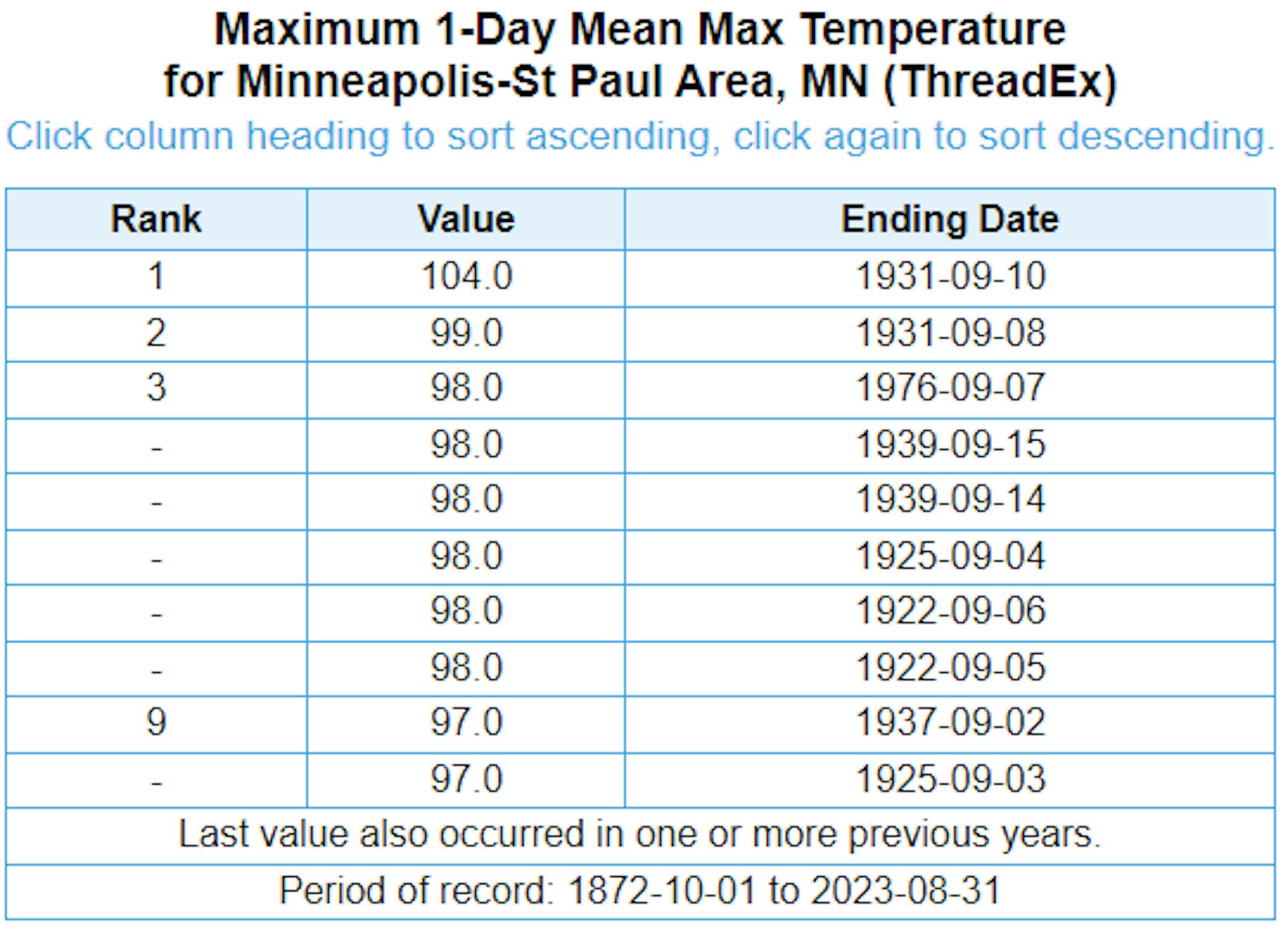
Hottest MSP Temps Ever Recorded in September

Here are the top 10 highest temperatures ever recorded in Minneapolis during the month of September. If we hit 100F this weekend, it would only the be the 2nd time that has ever happened. Regardless, we have at least a couple of chances of cracking the top 10 highest temps this weekend.

Hottest Minnesota State Fair Temps

Here are the hottest temperatures ever recorded at the Minnesota State Fair. 104F was the hottest set on September 10th in 1931. The most recent was 97F on August 26th in 2013. We could likely see some of the hottest temperatures ever recorded at the State Fair this weekend.

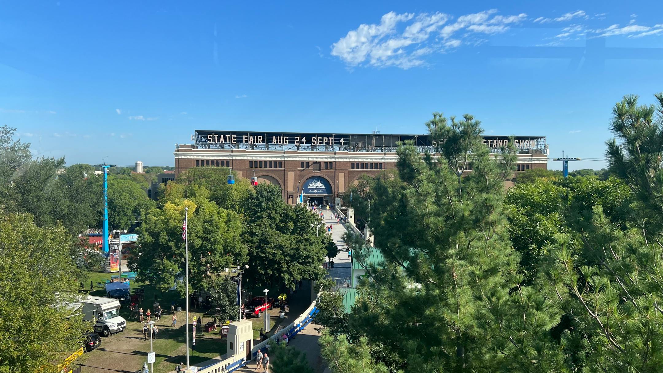
Minnesota State Fair Weather

"It's time once again for the "Great Minnesota Get Together." Weather plays quite a role in the State Fair experience. Who doesn't remember braving the heat with the crowds on one of the busier intersections on a sweltering afternoon? A quick rain burst will send people scurrying for cover, and folks savor balmy days in the 70s with just a bit of a breeze. Below are some State Fair weather facts and notable weather events that have happened in past Minnesota State Fairs. Quick History of the Minnesota State Fair The Minnesota State Fair has been held at its current site since 1885. Before that it was held at a variety of locations including Fort Snelling. There were some years when the Fair was not held because of war, disease, or for logistical reasons. These years are: 1861 (Civil War), 1862 (Civil and Indian War), 1893 (Columbian Exposition), 1945 (fuel shortage because of WWII), and 1946 (outbreak of Polio.) In 2020 the fair was not held due to COVID 19. Beginning in 1975, the fair has a 12-day run each year ending with Labor Day. Thus since 1975, the Fair begins on a Thursday in August. Before 1975, the Fair was held for shorter durations (eleven days from 1972 to 1974, ten days from 1939 to 1971, eight days from 1919 to 1938 and six days from 1885 to 1918). The 2023 Minnesota State Fair runs from August 24-Sepember 4."

See more from the State Climatology Office HERE:

Hottest Days of 2023 So Far

The hottest days of 2023 (so far) were back to back on August 22nd and 23rd, when the MSP hit 98F and heat index values peaking around 110F to 120F around the metro. Uffda! Through Sunday, August 27th, there have been (27) 90F days this year and tied for the 13th most number of 90F days in any year. The extended outlook brings us back into the 90s for the Labor day weekend, so we'll continue to add to that tally.

Average Number of 90F Days At MSP

Looking at the last 30 years, the average number of 90F days at the MSP Airport is (14). July is the hottest month with an average of (6) 90F days. This year we've had (23) 90F days, last year we had (18) days in the 90s and in 2021 there were (27) days in the 90s. The most number of 90F days in any single year was (44) set in 1988.

90 Day Precipitation Anomaly

On average, the wettest time of the year is in the summer, with the months of June, July and August seeing nearly 13" of rain at the MSP Airport. If we take a look at the 90 day precipitation anomaly, which dates back to about mid May, some locations are nearly -3.00" to nearly -7.00" below average (in red/pink). Note that some locations across southeastern Minnesota are nearly -8.00" to -10.00" below average.

Drought Update

Drought continues and expanded from last week with nearly 10% of the state now in an Extreme Drought. Severe Drought is now almost 40% and includes much of the Twin Cities metro. 3 months ago, 65% of the state was considered just abnormally dry.

Extended Precipitation Outlook

The extended precipitation outlook suggests some rainfall across parts of the state, but it certainly won't be enough to end the drought. Some spots might not even see any rainfall over the next 7 days.

Twin Cities Weather Outlook For Saturday

The weather outlook for the Twin Cities on Saturday, September 2nd could be a little unsettled in the morning. However, hot and sweaty sunshine develops as we head through the afternoon with highs warming into the mid 90s, which will be well above average and near records for this time of the year. Dewpoints will be a little sticky with readings in the low/mid 60s through the day.

Meteograms For Minneapolis

Weather conditions for Minneapolis through the day Saturday will get pretty hot and sticky. We'll see temps start in the low 70s in the morning and warm into the mid 90s by the afternoon, which will be well above average for this time of the year. Southerly winds will be a little breezy with gusts approaching 15mph to 20mph through the day.

Weather Outlook For Saturday

Temps on Saturday will warm into the 80s and 90s across the state, which will be nearly 10F to 20F above average for early September. These readings will be near record levels with mostly dry skies expected through the day.

Extended Temperature Outlook For Minneapolis

The 5 day temperature outlook for Minneapolis will be pretty hot through the long holiday weekend. Many communities will be near record levels with records likely on Sunday and Monday as we approach the century mark.

Sticky Dewpoints into Early September

The 5 day dewpoint forecast for Minneapolis looks a little sticky with readings warming into the 60s. Things should get a little better as we approach the end of next week.

Extended Weather Outlook For Minneapolis

The extended temperature forecast for Minneapolis will be extremely hot through the weekend and into early next week before more more comfortable weather arrives during the 2nd half of next week.

Record Breaking Heat This Weekend

According to NOAA's National Blend of Models, record breaking heat is possible over the weekend before cooling down to more tolerable levels during the 2nd half of next week.

Active Weather in the Atlantic

As of PM Friday, the National Hurricane Center was tracking several tropical waves in the Atlantic Basin, including Franklin, Idalia, Jose and Gert. Tropical Depression Twelve was also present along with another tropical wave that has a medium chance of development over the next 7 days.

Atlantic Basin Climatology

Our recent uptick in the Atlantic tropical activity coincides with climatology, which suggests that things ramp up pretty quickly during the 2nd half of August and into September. This is when the sea surface temperatures are typically the warmest in the Atlantic Basin. Note that the actual peak of the season is on September 10th, which is less than 3 weeks away. With that being said, the next several weeks could be pretty active in the Tropics.

Weather Outlook

Weather conditions in the Midwest could become a little unsettled just after Labor Day with a few showers and storms possible. Until then, it will be hot and drry.

8 to 14 Day Temperature Outlook

According to NOAA's Climate Prediction Center, the 8 to 14 day temperature outlook shows Warmer than average temperatures across much of the nation as we head through the first week of September.

8 to 14 Day Precipitation Outlook

According to NOAA's Climate Prediction Center, much of the Western US will be drier, while parts of the Midwest and Northeast will be a little more active.

Sweat on a Stick. Record Setting Heat This Weekend
By Todd Nelson, filling in for Douglas.

There must be some kind of mistake. I have a hard time believing it's September already. Can someone double-check that for me?

The Twin Cities just wrapped up the 5th warmest and 7th driest summer on record. Incredibly, the MSP Airport finished more than 7inches below normal precipitation since June 1st.Ouch! 3 months ago, 65 percent of the state was considered abnormally dry, but now 10 percent of the state is in extreme drought, while nearly 40 percent of us are in a severe drought, including the Twin Cities.

A few stray t-storms this morning beckon the arrival of another heat dome that'll set up over the region this weekend. The Great Sweat Together will live up to its name as highs soar into the upper 90s through Labor Day. Believe it or not, there's an outside chance we hit 100 degrees tomorrow and possibly again Monday, which would be record highs for the day and one of the hottest days ever registered at the Fair and for the month of September! The hottest Fair day on record was 104 degrees on September 10th, 1931. Good grief!

Extended Forecast

SATURDAY: AM T-Shower. Hot PM sun. Winds: SSW 5-10. High: 94.

SATURDAY NIGHT: Breezy and mild. Winds: SW 15-25. Low: 77.

SUNDAY: Shot at 100F? Record: 97F in 1925. Winds: SW 5-10. High: 100.

MONDAY: Sweaty at the Fair. Record 98F in 1925. Winds: SW 10-20. Wake-up: 75. High: 98.

TUESDAY: Hot back to school. Late day storms. Winds: SSW 10-20. Wake-up: 77. High: 95.

WEDNESDAY: AM Storm. PM clearing. Falling temps. Winds: NNW 10-15. Wake-up: 68. High 85.

THURSDAY: Sunny and comfortable. Winds: ESE 5-10. Wake-up: 62. High 78.

FRIDAY: Beautiful September day. Looks dry. Winds: ESE 5-10. Wake-up: 60. High 81.

This Day in Weather History

September 2nd

1996: Approximately 8 inches of rain falls over a 2 1/2 hour period in the Mankato area resulting in flash flooding. Numerous roads are closed, basements flooded, and $100,000 of damage results from a lightning strike in Lehiller.

1992: Severe weather affects several counties in the western parts of the County Warning Area. Several tornadoes are reported, along with 3/4 inch hail and damaging winds, as the system passes through Pope, Swift, Stearns, Kandiyohi, Meeker, Brown and Renville Counties.

1975: Severe weather rolls through Stevens, Swift, Kandiyohi, and Meeker counties. 1.5 inch Hail is reported in Stevens and Swift. An F1 tornado also occurs in Swift. An hour later, another F1 Tornado was reported in Kandiyohi County while 69 knot winds occurred in Meeker County. Damages were estimated at $50,000 for the two tornadoes that touched down.

1937: Strong thunderstorms bring heavy rainfall to northern Minnesota, with 4.61 inches of rain dumped on Pokegama. Flooding was reported in Duluth.

Average High/Low for Minneapolis

September 2nd

Average High: 78F (Record: 97F set in 1937)

Average Low: 59F (Record: 42F set in 1974)

Record Rainfall: 1.97" set in 2000

Record Snowfall: NONE

Sunrise/Sunset Times for Minneapolis

September 2nd

Sunrise: 6:36am

Sunset: 7:48pm

Hours of Daylight: ~13 hours & 12 minutes

Daylight LOST since yesterday: 3 Minutes & 00 Seconds

Daylight LOST since Summer Solstice (June 21st): ~ 2 Hour & 25Minutes

Moon Phase for September 2nd at Midnight

3.2 Days After The Full "Blue" Moon

"Aug. 30 at 8:36 p.m. CDT - The second full moon occurring within a calendar month is usually bestowed this title. Although the name suggests that to have two Full Moons in a single month is a rather rare occurrence (happening "just once in a . . . "), it actually occurs once about every three years on average. There is actually a second and more arcane definition of a Blue Moon, apparently conceived by an almanac editor based in Maine back in the 1930s, but we will not get into this here. In addition, the moon will also be at perigee at 12:00 p.m. EDT., at a distance of 221,942 miles (357,181 km) from Earth. Very high tides can be expected from the coincidence of perigee with full moon (referred to as an astronomical spring tide). Finally, a full moon occurring very late in August or very early in September is sometimes bestowed with the title of Fruit Moon or Barley Moon. This will be the case with this second August full moon in 2023."

See more from Space.com HERE:

National High Temps on Saturday

Temperatures on Saturday will be well above average across the Central US, where temperatures will be nearly 10F to 20F above average.

National Weather Saturday

The weather outlook on Saturday will be a little unsettled across the Western US with showers and storms. There will also be areas of showers and storms across the Southern US with pockets of locally heavy rainfall.

National Weather Outlook

The weather outlook through Sunday will be fairly unsettled across the Western US with widespread showers and storms moving through. Areas of locally heavy rainfall will be possible. There will also be pockets of locally heavy rainfall across the Gulf Coast States.

Extended Precipitation Outlook

The extended precipitation outlook shows decent rainfall across the Intermountain West through early next week. There will also be decent rainfall across the Gulf Coast States.

Climate Stories

"What's in Floodwaters?"

"When storms such as Hurricane Idalia—which hit Florida's Gulf Coast as a Category 3 hurricane on Wednesday—inundate areas with a storm surge and torrential rain, the resulting floodwaters pose major risks beyond the immediate physical damage they cause. As water accumulates in a region, whether the cause is a storm's effects, a dam failure or any other reason, it picks up a host of threats to human health, including bacteria, viruses, chemicals, debris, downed power lines and even wild animals. And those threats are only increasing as climate change causes floods to become more frequent around the world. "Flooding is going to continue to be an increasingly common problem," says Thomas Frazer, an ecologist at the University of South Florida, who studies flooding. "We're faced with a reality of rising sea levels, more intense tropical storms and hurricanes and just extreme rainfall events more generally."

See more from Scientific American HERE:

"September's night sky will sparkle with the Harvest Moon and a newly discovered comet"

"Summer skygazing season in the Northern Hemisphere is quickly drawing to a close. September 1 marks the beginning of meteorological autumn, and we are racing towards the Autumnal Equinox. While the temperatures may finally start to get a little bit cooler, the night sky is staying pretty hot with a very bright Mercury beginning in mid-September, a meteor shower, and the last supermoon of the year. Here are some events to look out for this month and if you happen to get any stellar sky photos, please tag us and include #PopSkyGazers. September 1- Aurigid Meteor Shower Predicted to Peak The day after August's Blue Moon, the Aurigid meteor shower is predicted to reach its peak. This meteor shower has been active since August 28 and will wrap up on September 5. From the eastern US, the shower will likely be visible around 11:30 PM each night when its radiant point rises above the eastern horizon. It is predicted to remain active until dawn breaks at around 5:51 AM. In the Sky estimates that viewers could see about five meteors an hour and that the bright moon will likely cause some viewing interference."

See more from Popular Science HERE:

"Climate change makes wildfires in California more explosive"

"During some of the worst hours in Camp Fire, which in 2018 burned the town of Paradise, California to the ground, the fire was growing so fast it ate up 10,000 acres within just 90 minutes. Wildfires like the Camp Fire that intensify and spread enormously within a single day, hour, or even minutes, keep fire experts up at night. Now a new study, published Wednesday in Nature, uses a machine-learning model to show that climate change has nudged the risk of fast-spreading fires up by about 25% on average in California. That's compared to a time before humans heated up Earth's atmosphere by burning vast amounts of fossil fuels. "We're seeing the impact of climate change for the first time on that high-resolution fire behavior," says Patrick Brown, the study's lead author and a climate scientist at Berkeley's Breakthrough Institute. The dangers didn't increase evenly. Of the 18,000 California fires that sprang to life from 2003 to 2020, 380 of them included at least one day when they grew by at least 10,000 acres — an area as big as most of Manhattan. Climate change ramped up the likelihood of that growth for most of the fires–but not all of them."

See more from NPR HERE:

Thanks for checking in and don't forget to follow me on Twitter @TNelsonWX