A Few Rough Thunderstorms Later Today?

Showers and storms will be possible on Saturday, some of which could be strong to severe with isolated large hail and damaging winds. Check the blog for more details. -Todd Nelson

September 17, 2022 at 3:05AM
September Sunset (Erin Allbee/The Minnesota Star Tribune)

Severe Threat Later Saturday

According to NOAA's SPC, there is a risk of strong to severe thunderstorms later today across parts of the state. The greatest risk (in yellow) could see a better chance of isolated strong winds gusts, large hail and possibly a brief tornado.

SPC Threat Saturday (NOAA SPC/The Minnesota Star Tribune)

Fall Color Update

It's that time of the year again for fall colors and the MN DNR has their fall color finder up and running. Much of the state is still color free, but there are a few colors popping up here and there.
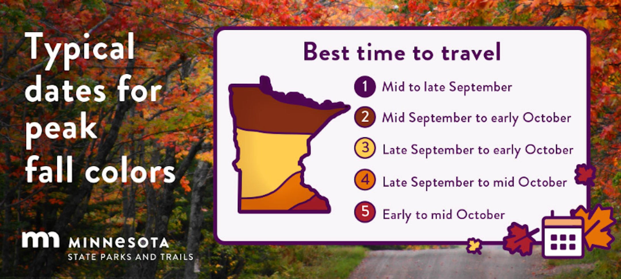
Fall Color Update (MN DNR/The Minnesota Star Tribune)

Average Fall Color

The MN DNR has put together a nice graphic that shows typical dates for peak fall color. The northern par of the state starts to peak during the 2nd half of September into early October. Meanwhile, folks in the central part of the state and into the metro typically don't see peak color until the end of September into the middle part of October. It won't be long now - enjoy!

Average Fall Color Dates (MN DNR/The Minnesota Star Tribune)

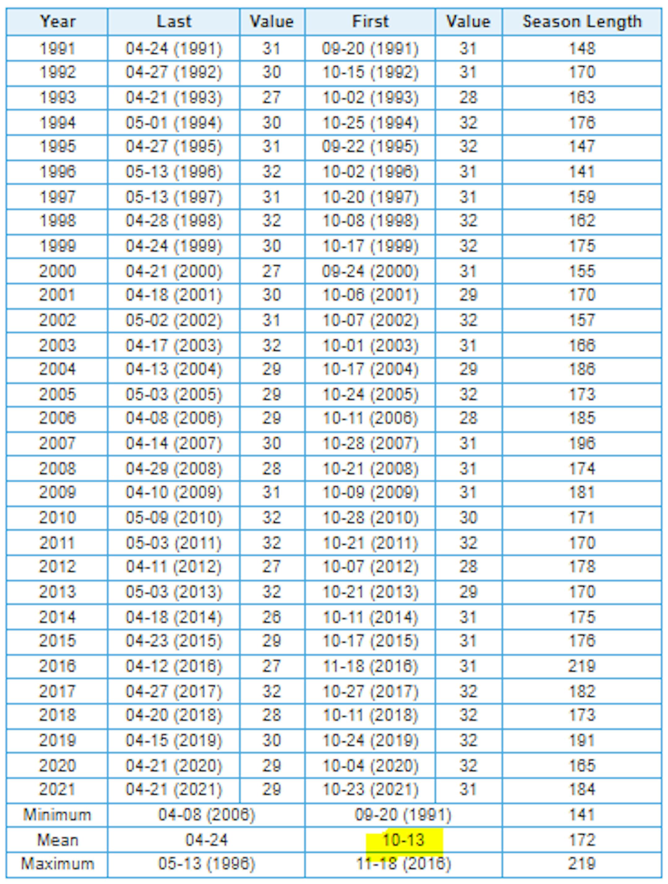
Average First Frost For MSP

Here's the 30 year average for the first frost in Minneapolis, which lands on October 13th. Last year (2021) the first frost was on October 23rd. If you look at the full MSP record, which dates back to 1873, the latest frost was November 18th back in 2016, while the earliest frost was September 3rd back in 1974.

Average First Frost (32F) For Minneapolis (NOAA NWS/The Minnesota Star Tribune)

First Measurable Snow at MSP

Here's the average first measurable snowfall (0.01") at MSP over the last 30 years, which lands on November 6th. Last year, MSP had its first measurable snow on November 13th. The last was on December 3rd back in 1928, while the earliest was September 24th in 1985.

First Measurable Snow at MSP (NOAA NWS/The Minnesota Star Tribune)

Dry Through Midweek, Then Unsettled.

Here's the weather outlook from AM Saturday to AM Monday. Weather conditions through the weekend will be a little unsettled with spotty showers and storms. Some of the rainfall could be locally heavy, especially north and east of the Twin Cities.

Weather Outlook From AM Saturday to AM Monday (Tropical Tidbits/The Minnesota Star Tribune)

Extended Precipitation Outlook

The extended precipitation outlook shows areas of heavy rainfall across the Arrowhead and into Wisconsin. Drier weather will be in place across the Southwestern MN.

Precipitation Outlook Through Monday (WeatherBell & NOAA WPC/The Minnesota Star Tribune)

Minnesota Drought Update

Here's the latest drought update across Minnesota. As of September 13th, we still have a sliver of moderate and severe drought conditions stretching from the Twin Cities Metro to the Minnesota River Valley.

MN Drought Update (US Drought Monitor/The Minnesota Star Tribune)

Weather Outlook on Saturday

The weather outlook on Saturday shows spotty showers and storms across the region with temps warming into the 70s and 80s. Temps will only be in the 60s across northwestern MN and into North Dakota.

Saturday Weather Outlook on Saturday (Praedictix/The Minnesota Star Tribune)
Highs From Average on Saturday (Praedictix/The Minnesota Star Tribune)

Weather Outlook Saturday

The weather outlook for Minneapolis on Saturday shows spotty showers and storm chances through the day with high temps warming into the lower 80s.

Saturday Weather Outlook For Minneapolis (Praedictix/The Minnesota Star Tribune)

More Humid Next Few Days

The extended weather outlook over the new days shows sticky dewpoints in the 60s through early next week.

Daily Max Dewpoint Forecast For Minneapolis (Praedictix/The Minnesota Star Tribune)

Meteograms for Minneapolis

The hourly forecast for Minneapolis on Saturday shows temps starting in the mid 60s in the morning with highs topping out in the lower 80s in the afternoon. Southerly winds will gust close to 15mph in the afternoon.

Hourly Temps & Sky Conditions For Minneapolis on Saturday (Praedictix/The Minnesota Star Tribune)
Hourly Wind Gusts & Direction For Minneapolis on Saturday (Praedictix/The Minnesota Star Tribune)

Extended Temperature Outlook For Minneapolis

The extended temperature outlook for Minneapolis shows readings running above average by nearly +5F to +10F over the next several days with a slight increase in humidity values as we head through the weekend and into early next week. The warmest day could be next Tuesday with highs in the upper 80s

5 Day Temperature Outlook For Minneapolis (Praedictix/The Minnesota Star Tribune)

Extended Weather Outlook For Minneapolis

The extended weather outlook over the next 7 days shows warm temperatures in place over the next several days. It'll be a little cooler late week with temps dipping into the 60s.

7 Day Weather Outlook For Minneapolis (Praedictix/The Minnesota Star Tribune)

Extended Temperature Outlook For Minneapolis

According to the NBM & ECMWF extended temperature outlook shows above average temps through early next week. Temps will be a little cooler as we approach the end of the month.

ECMWF Extended Temperature Outlook For Minneapolis (Praedictix/The Minnesota Star Tribune)
NBM Extended Temperature Outlook For Minneapolis (WeatherBell/The Minnesota Star Tribune)

8 to 14 Day Temperature Outlook

According to NOAA's Climate Prediction Center, the 8 to 14 day temperature outlook shows above average temps continuing across much of the southern and western US with cooler temps in the Great Lakes.

8 to 14 Day Temperature Outlook (NOAA CPC/The Minnesota Star Tribune)

8 to 14 Day Precipitation Outlook

According to NOAA's Climate Prediction Center, the 8 to 14 Day precipitation outlook shows dry weather in place across much of the northern tier of the nation and the Central US.

8 to 14 Day Precipitation Outlook (NOAA CPC/The Minnesota Star Tribune)

Activity in the Atlantic

As of late Friday, Tropical Storm Fiona was moving into the northeastern Caribbean. Tropical storm watches and warnings have been posted from the Leeward Islands to the Dominican.

5 Day Tropical Outlook (NOAA NHC/The Minnesota Star Tribune)

A Few Rough Thunderstorms Later Today?
By Paul Douglas

September is sweet relief. Summer is fading but skies are generally lukewarm and quiet. It's like waving goodbye to a dear friend while waiting for your crazy uncle to show up, clutching an ice scraper and a tattered face mask.

As a rule severe thunderstorms are rare, the result of a cooling, stabilizing airmass near the ground. Today may prove to be the exception to that rule, with a "slight risk" of severe storms, hail and damaging winds over central Minnesota, according to NOAA's Storm Prediction Center. Morning activities may be OK, but keep an eye on the sky during the afternoon and evening hours. Silver lining: weather models hint at some .5 to 1" rainfall amounts.

Sunday should the sunnier, drier day of the weekend with highs in the 70s. After upper 80s Tuesday a spirited round of showers arrive Wednesday, blown along by northwest winds gusting to 30 mph. By Thursday there will be no doubt in your mind that autumn has arrived. Highs hover in the 60s late next week, but I expect a few more warm fronts.

Extended Forecast

SATURDAY: Warm sun, PM severe storm? Winds: S 8-13. High: 82.

SATURDAY NIGHT: Chance of t-storms overnight. Winds: ESE 5. Low: 64.

SUNDAY: Partly sunny and pleasant. Winds: NW 7-12. High: 76.

MONDAY: Plenty of sunshine, quiet. Winds: SE 5-10. Wake-up: 59. High: 79.

TUESDAY: Early thunder then sunny and warm. Winds: W 5-10. Wake-up: 65. High: 87.

WEDNESDAY: Showers & storms, gusty and cooler. Winds: NW 15-30. Wake-up: 62. High: 68.

THURSDAY: Scrappy clouds with a cool wind. Winds: NW 15-25. Wake-up: 54. High: 63.

FRIDAY: Partly sunny and cool. Winds: S 5-10. Wake-up: 53. High: 64.

This Day in Weather History

September 17th

1955: A late-season tornado hits Koochiching County. Most damage is confined to trees.

1911: Pipestone is hit with baseball-sized hail that smashes numerous windows at the Calumet Hotel and high school. The local observer measures hail three inches deep. People get their photos taken in automobiles surrounded by the icy white ground.

Average High/Low for Minneapolis

September 17th

Average High: 73F (Record: 96F set in 1895)

Average Low: 54F (Record: 34F set in 1875 & 1943)

Record Rainfall: 2.37" set in 2015

Record Snowfall: None

Twin Cities Almanac For For September 17th (Praedictix/The Minnesota Star Tribune)

Sunrise/Sunset Times for Minneapolis

September 17th

Sunrise: 6:54am

Sunset: 7:20pm

Hours of Daylight: ~12 hours & 26 minutes

Daylight LOST since yesterday: ~ 3 minutes & 5 seconds

Daylight LOST since Winter Solstice (December 21st): ~ 3 hour & 12 minutes

Moon Phase for September 17th at Midnight

0.4 Days Before Last Quarter Moon

Moon Phase For September 17th at Midnight (Praedictix/The Minnesota Star Tribune)

National High Temps Saturday

The weather outlook on Saturday shows warmer than average temps returning to the middle part of the country. Meanwhile, cooler than average temps will return to the Western US.

National Weather Outlook For Saturday (NOAA WPC/The Minnesota Star Tribune)
National Highs From Average on Saturday (Praedictix/The Minnesota Star Tribune)

National Weather Outlook Saturday

Areas of showers and storms will be possible across the Midwest, some of which could be strong to severe with locally heavy rainfall.

National Weather Outlook on Saturday (Praedictix/The Minnesota Star Tribune)

National Weather Outlook

Here's the weather outlook through Sunday, which shows unsettled weather across the Midwest with pockets of locally heavy rain. There will also be areas of heavy rain moving into parts of California.

Weather Outlook Through Sunday (NOAA WPC/The Minnesota Star Tribune)

Extended Precipitation Outlook

According to NOAA's Weather Prediction Center, areas of heavier precipitation will continue across Florida with localized flooding possible. There will also be decent rainfall amounts through California, Intermountain-West and also closer to Lake Superior.

Extended Precipitation Outlook (NOAA WPC/The Minnesota Star Tribune)

Climate Stories

(NOAA/The Minnesota Star Tribune)

"A giant fireball was seen shooting across the U.K. sky. Here's what meteorologists think it was"

"Hundreds of people across the United Kingdom had front-row seats to an exciting mystery that literally went right over their heads on Wednesday night. A massive fireball shot across the sky, puzzling hundreds of people across Scotland, Ireland and England. The fast-moving fireball was caught on several cameras at around 10 p.m. local time. Some witnesses described it as looking green while videos showed it surrounded by a wide-ranging flashing aura as it bolted across the clouds. For Steve Owens, an astronomer and science communicator at the Glasgow Science Centre, the sighting was "incredible," he told BBC."

"Citing a fivefold increase in weather-related disasters, a new UN report urges more ambitious climate goals"

"A new multi-agency report from the World Meteorological Organization (WMO) has a stark and dire warning for the entire planet: we are heading in the wrong direction on climate change. "The science is clear. Urgent action is needed to mitigate emissions and adapt to the changing climate," says the report."

"Mapped: America's extreme summer weather of 2022"

"It was a relentlessly hot summer in much of the U.S., especially across the Plains, Southwest and West, according to new data from the National Oceanic and Atmospheric Administration (NOAA). The big picture: While each month had its own quirks, there were two constants: extreme heat in Texas and Oklahoma and damaging flash flooding in multiple locations across the country as rainfall records were shattered. For meteorological summer, which runs from June 1 through Aug. 31, the U.S. average temperature was 2.5°F above average for the season. This made it the third-hottest summer in 128 years, NOAA found."

Thanks for checking in and don't forget to follow me on Twitter @TNelsonWX

@TNelsonWX (The Minnesota Star Tribune)

about the writer

Todd Nelson

See More