Sunny And Near Average Sunday - Above Average Highs Return To End November

No weather concerns across the state if you're heading back home during daylight hours on Sunday, though a few rain or snow showers will start to work into western Minnesota during the evening. Highs will be in the 30s Sunday but return to the 40s for much of the work week. Click for more - D.J. Kayser

November 28, 2021 at 12:10AM
(The Minnesota Star Tribune)

Sunday Weather Outlook

(The Minnesota Star Tribune)

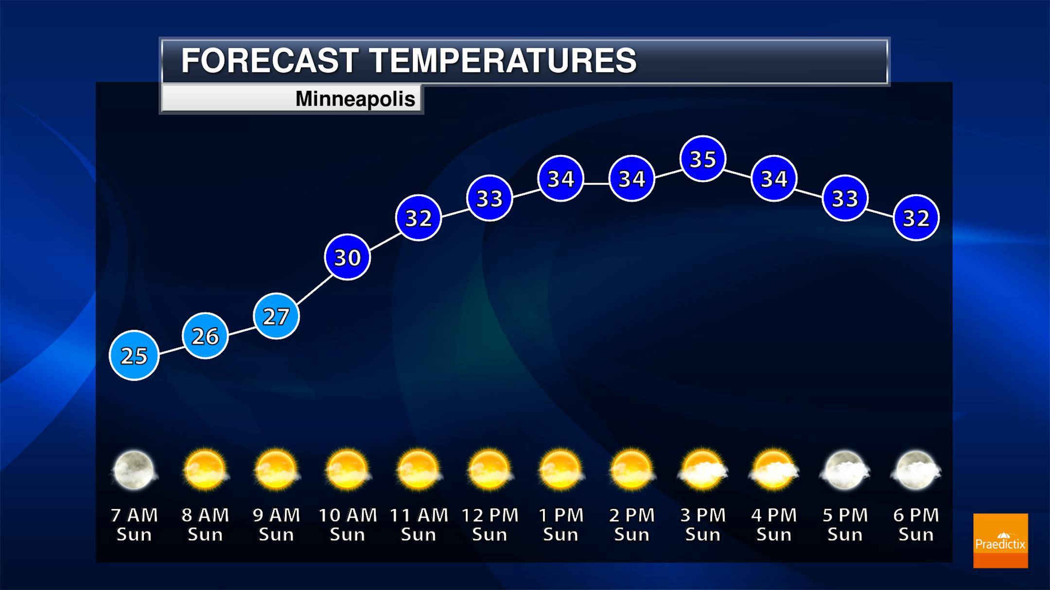
Sunny skies look to reign the sky on Sunday in the Twin Cities, with morning lows dipping to the mid-20s and highs climbing to the mid-30s.

(The Minnesota Star Tribune)

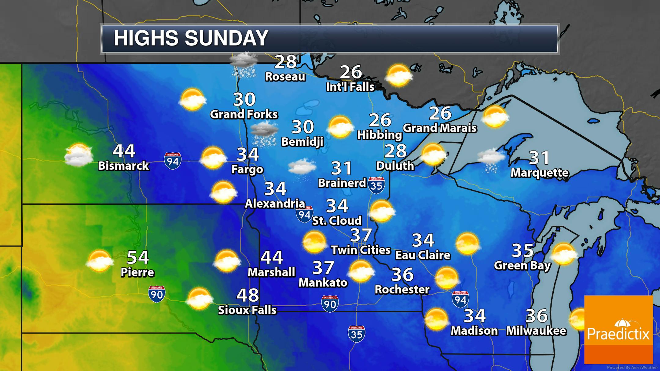
Most of the state will see dry weather during daylight hours on Sunday, with precipitation starting to work into portions of western Minnesota toward the evening hours in the form of snow or a mix of rain and snow. Some of this precipitation could fall as far south as the Twin Cities Sunday Night in association with a system moving into the region. Highs across much of the state will be in the 20s and 30s, with some 40s expected in southwestern Minnesota.

_______________________________________________

How Will We End The Month Weatherwise?

(The Minnesota Star Tribune)

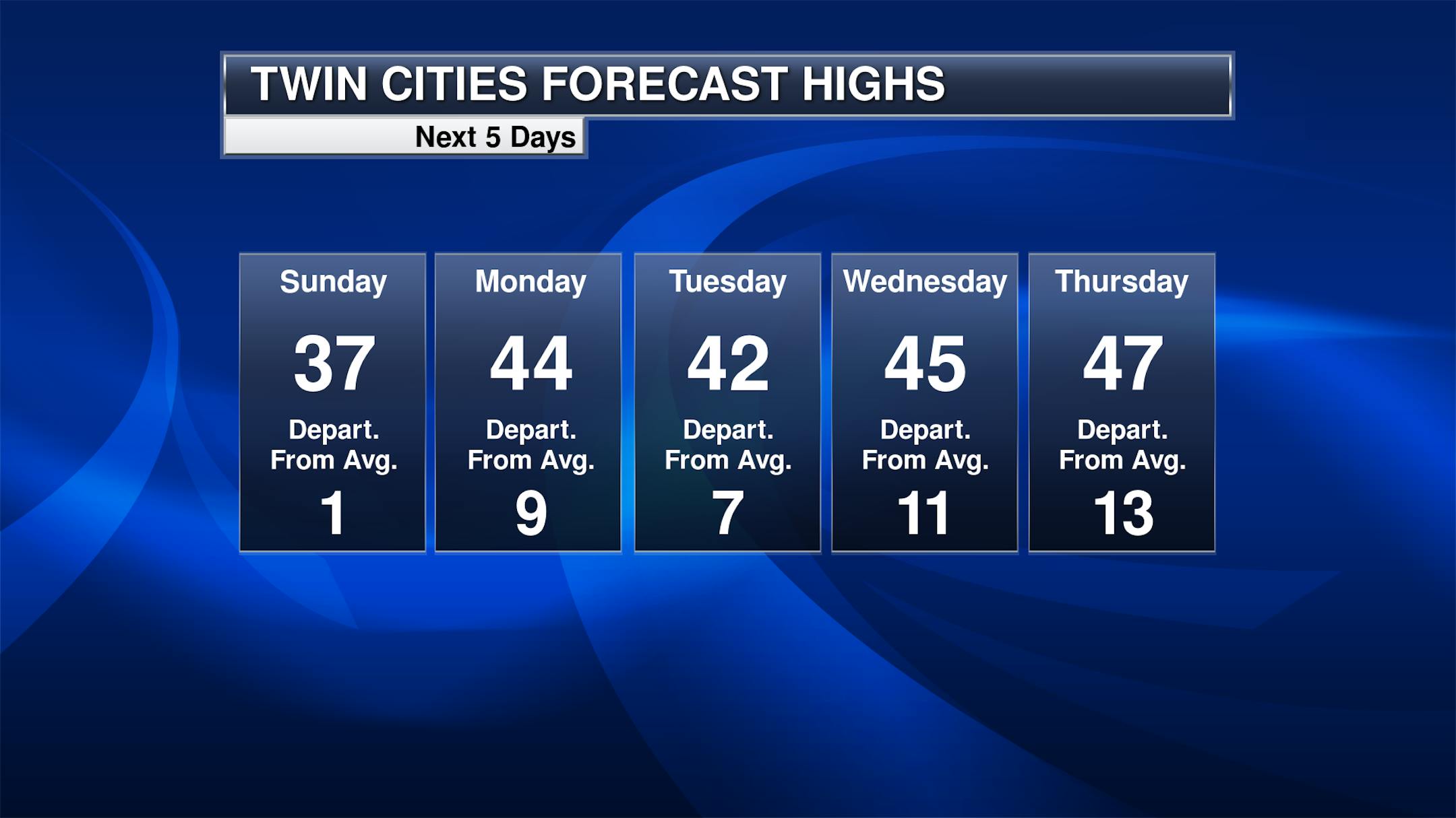
That system brings in some warmer weather for Monday in the Twin Cities with highs climbing into the mid-40s. They'll take a step back - but only to the low 40s - for the last day of November before we start the first couple days of December on the warm side with highs 10-15F degrees above average. For the most part, we should be dry through the entire work week in the Twin Cities.

_______________________________________________

An Octoberish Week - Snow Potential Brewing
By Paul Douglas

Boating in early December, in Minnesota? I wouldn't rule it out. It's not scientific but my "TSSD Scale" and "Loafer Index" may be instructive.

TSSD: Time Spent Staring at Doppler. In the last few weeks I've spent a few minutes plugged into Doppler Radar. A lack of real storms will do that. Odds are you've seen people (young men) wandering around in shorts? At this rate I'll be wearing my favorite loafers into early December. But our favorite boots may see action next weekend.

We cool off slightly today, but Pacific air means 4 or 5 days in the 40s this week; even 50F. It may even rain a little on the first day of December before we cool down next weekend.

And that's when things may get interesting. Models differ on timing, but with a cold dome in place and a storm tracking south of Minnesota, conditions may be ripe for accumulating snow by Saturday or Sunday. How much? Too early to say with confidence, but if everything goes just right, plowable amounts could fall. The clock is ticking on your green lawn.

_______________________________________________

Paul's Extended Twin Cities Forecast

SUNDAY: Some sun, mix tonight. Wake up 25. High 37. Chance of precipitation 40%. Wind NW 8-13 mph.

MONDAY: Increasing sunlight, mild. Wake up 31. High 42. Chance of precipitation 20%. Wind NW 8-13 mph.

TUESDAY: Partly sunny and quiet. Wake up 30. High 44. Chance of precipitation 10%. Wind S 5-10 mph.

WEDNESDAY: Rain showers on December 1? Wake up 37. High 45. Chance of precipitation 60%. Wind SW 8-13 mph.

THURSDAY: Partial clearing, drying out. Wake up 38. High 41. Chance of precipitation 20%. Wind NW 15-25 mph.

FRIDAY: Few rain/snow showers. Wake up 28. High 38. Chance of precipitation 30%. Wind SW 10-15 mph.

SATURDAY: Snow arrives, accumulation possible. Wake up 27. High 31. Chance of precipitation 60%. Wind NE 10-20 mph.

_______________________________________________

Minneapolis Weather Almanac And Sun Data
November 28th

(The Minnesota Star Tribune)

*Length Of Day: 9 hours, 6 minutes, and 22 seconds
*Daylight LOST Since Yesterday: 1 minute and 42 seconds

*When Do We Drop Below 9 Hours Of Daylight? December 3rd (8 hours, 58 minutes, and 44 seconds)
*Next Sunrise At Or After 7:30 AM: November 30th (7:30 AM)
*Earliest Sunsets Of The Year: 4:31 PM between December 5th and December 14th

_______________________________________________

This Day in Weather History
November 28th

1983: Widespread snowfall occurs across much of central Minnesota with snowfall totals at or above 1 foot in many areas. A record 15 inches fell in Gaylord and 14 inches fell in Farmington.

1960: A major storm produces near hurricane force winds on Lake Superior, with 20 to 40 foot waves on the lake. Erosion and damage occurred on the North Shore.

_______________________________________________

National Weather Forecast

(The Minnesota Star Tribune)

A system in the Great Lakes will bring rain and snow from the Great Lakes to the Northeast on Sunday, while another warm front stretching into the Upper Midwest could bring wintry precipitation by the evening and overnight hours. An area of low pressure in the Gulf of Mexico with a cold front stretching into the Deep South could bring showers to the Gulf Coast and lower Mississippi Valley. Rain and snow will continue to impact portions of the Pacific Northwest.

(The Minnesota Star Tribune)

The heaviest snow over the next few days looks to fall downwind of the Great Lakes, with several inches expected to accumulate in some locations, especially near Lake Erie. The heaviest rain will be up in the Pacific Northwest as atmospheric rivers continue to impact the region with some of the heaviest falling near the coast and at higher elevations.

_______________________________________________

New York's Right to 'a Healthful Environment' Could Be Bad News for Fossil Fuel Interests

More from Inside Climate News: "When New York regulators denied a key permit to the controversial Williams Pipeline in early 2020, in part because it conflicted with the state's climate law, environmental policy experts called it a potential turning point. No longer could developers pitch major fossil fuel projects in the state without expecting serious regulatory scrutiny or legal challenges, climate campaigners said, touting the decision as a victory for the state's clean energy aspirations. That forecast was reinforced in October. State regulators denied permits for two proposed natural gas power plants, again citing the landmark climate law, which requires New York to transition its power sector to net-zero emissions by 2040 and to reduce overall greenhouse gas emissions 85 percent below 1990 levels by 2050."

Living walls can reduce heat lost from buildings by over 30%, study shows

More from the University of Plymouth: "Retrofitting an existing masonry cavity walled building with a green or living wall can reduce the amount of heat lost through its structure by more than 30%, according to new research. The study, conducted at the University of Plymouth, centred around the Sustainability Hub – a pre-1970s building on the university campus – and compared how effectively two sections of its walls retained heat. Despite being on the same west-facing elevation, one of those sections had been retrofitted with an exterior living wall façade, comprised of a flexible felt fabric sheet system with pockets allowing for soil and planting."

Climate emergency accelerates F1's efforts to clean up its image

More from The Guardian: "The gas-guzzling behemoth, the gaudy polluter roaring its indifference to the problems facing the planet, Formula One has an image problem in the climate emergency age. But is it a fair judgment any more? F1's sporting director, Ross Brawn, believes that the sport's technological battleground is turning into an environmental science lab pursuing solutions to issues that cannot be ignored. F1 has much to do to make a difference but it is taking a path that deserves recognition and perhaps reassessment of how it is perceived. Brawn describes the new direction as compulsory both commercially and morally. "Every thinking person is concerned about climate change," he says. "I am concerned about it, my engineers are concerned about it – it's something we can't ignore. It would be very rewarding for F1 to demonstrate the technology we can take forward to contribute to the reduction of greenhouse gases."

_______________________________________________

Thanks for checking in and have a great day! Don't forget to follow me on Twitter (@dkayserwx) and like me on Facebook (Meteorologist D.J. Kayser).

- D.J. Kayser

(The Minnesota Star Tribune)

about the writer

D.J. Kayser

See More