Another Multi-Day System Brings Rain And Snow To End March

Forecast loop between 7 AM Thursday and 7 PM Friday.

We're tracking another messy spring system impacting the region as we head into the end of the week. This will come in two waves:

  • Thursday into Thursday Night: For the metro and southern Minnesota, it will likely start off as some light snow or flurries midday Thursday before transitioning to rain. A few thunderstorms will be possible Thursday Night, and some of those could be strong in southwestern Minnesota. Farther north and west, some icing of up to around a tenth of an inch will be possible from Redwood Falls through the St. Cloud area to the Twin Ports. North of that in northern Minnesota, 3-6" of snow will be possible.
  • Friday into Friday Night. A little lull in precipitation may occur Friday morning before more rain and snow move in midday/afternoon. This will change over to snow from northwest to southeast through the afternoon into the evening hours, with that changeover occurring in the metro sometime around or a little bit after sunset. Several inches of heavy, wet snow is expected to occur during this time frame. Winds will also be a concern, gusting up to 50 mph in parts of the state, potentially causing blizzard conditions.

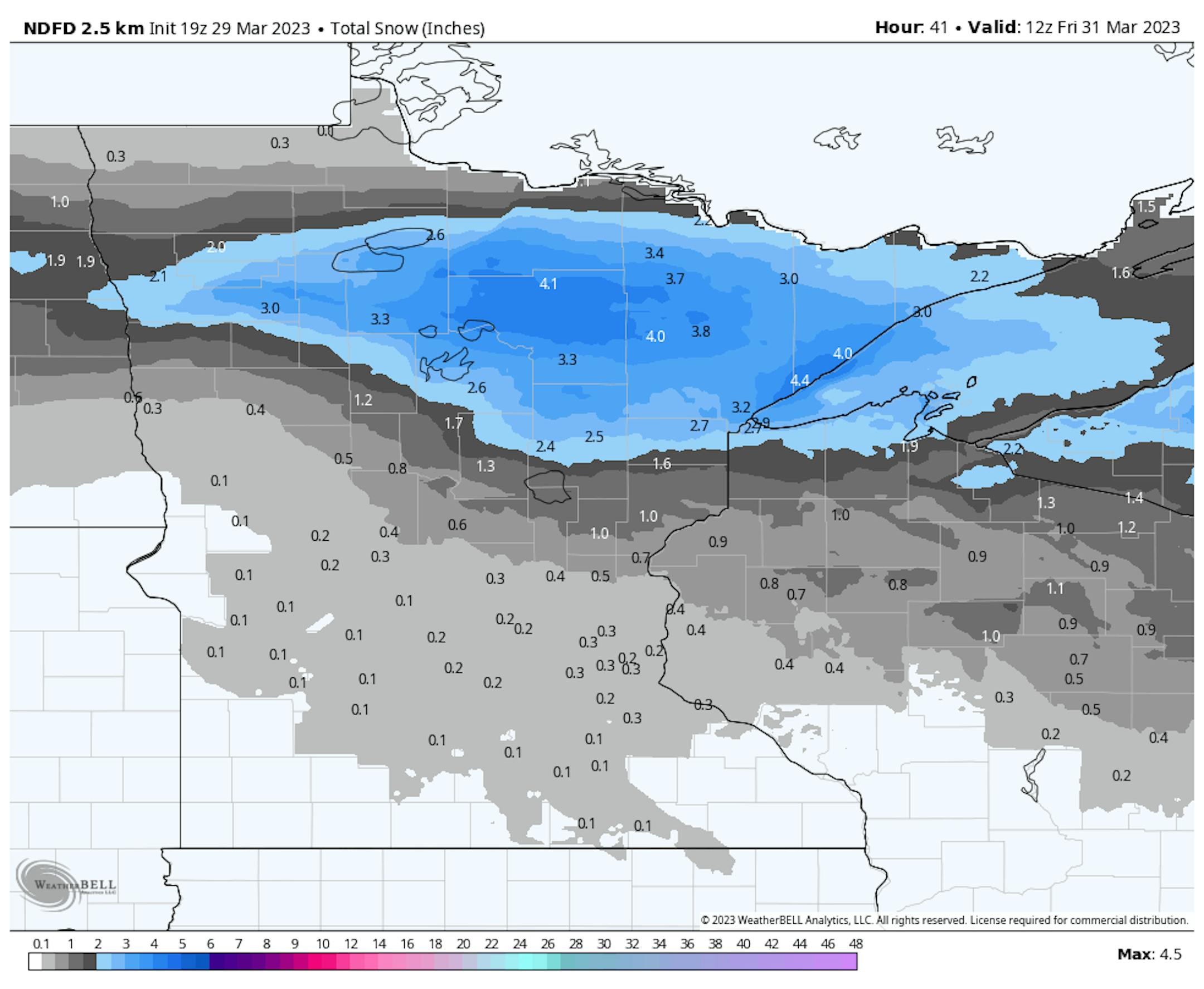
First Round Of Snow: The heaviest will fall across northern Minnesota, where again 3-6" of snow could fall Thursday into Thursday Night.

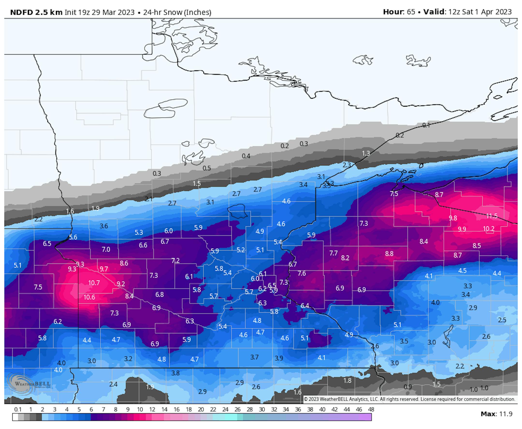
Second round of snow: This will mainly target central and southern Minnesota, and there will be the potential of 4-10" of snow in a band across the region.

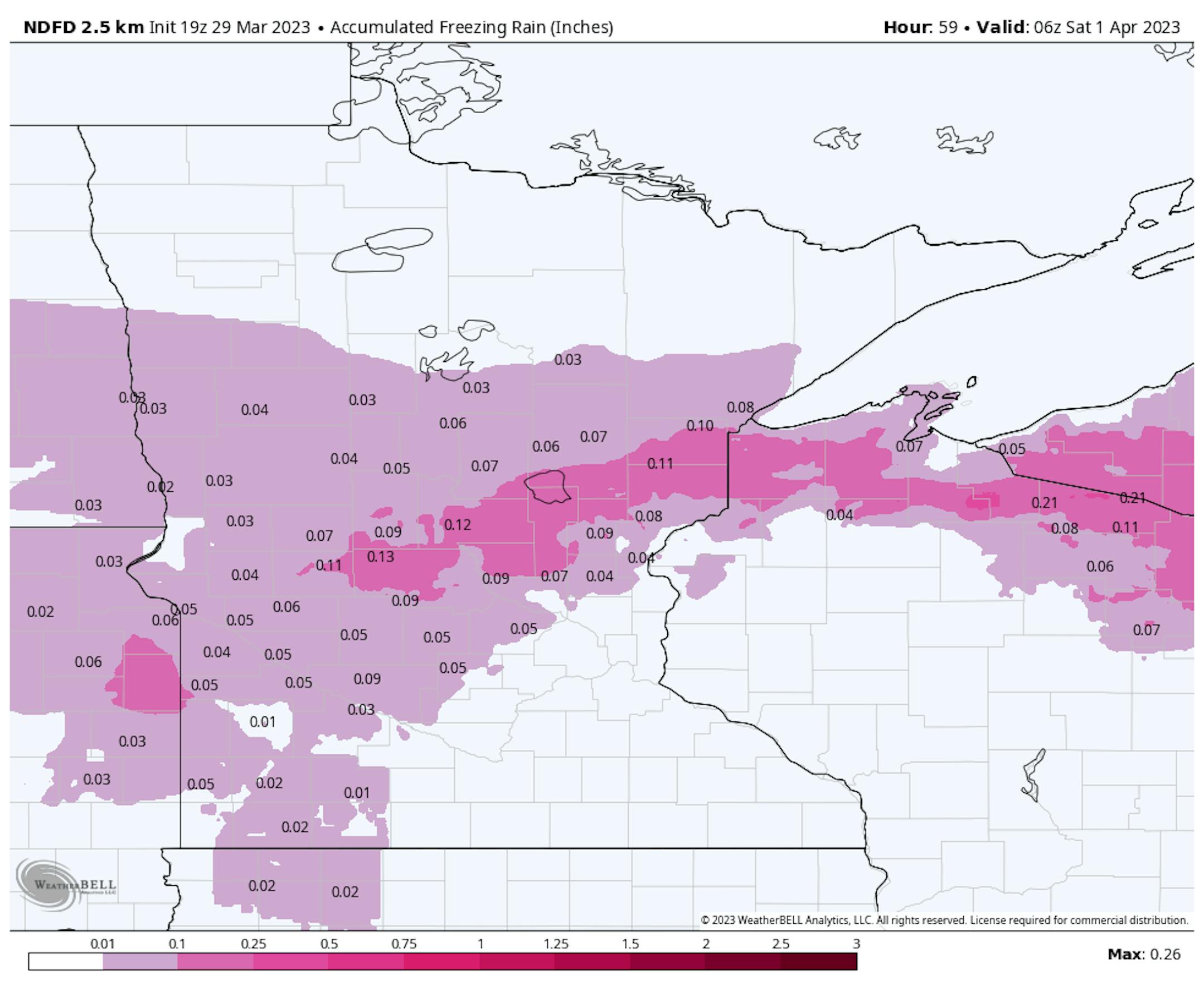
Icing: Areas from western Minnesota across central Minnesota to the Twin Ports could see between 0.05" and 0.15" of ice, mainly Thursday afternoon into Friday morning.

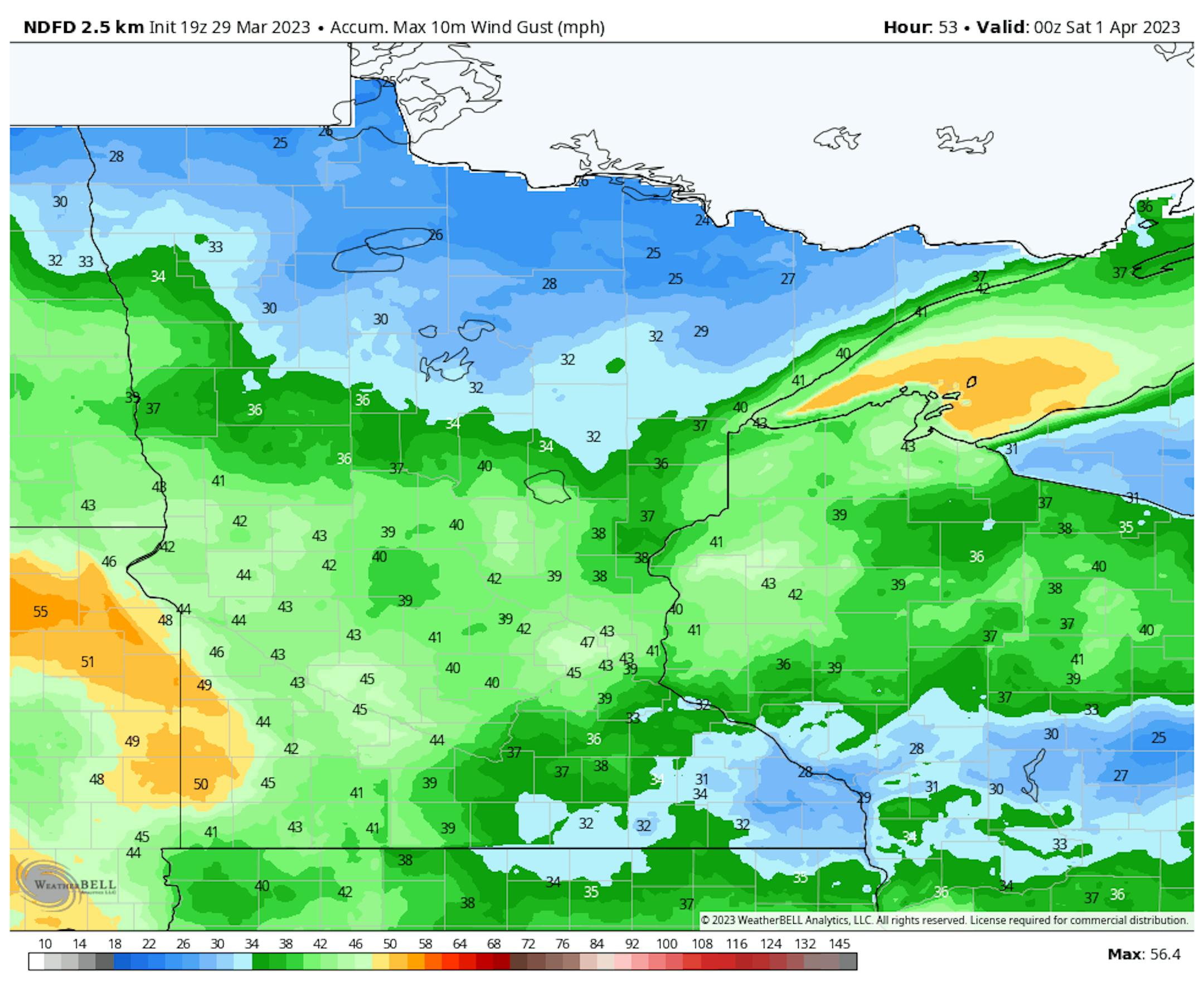
Winds: They'll be strongest Friday into Friday Night, which is when we could see some areas of the state see wind gusts around 50 mph. These winds will cause blowing and drifting snow as well as whiteout/blizzard conditions.

Due to the expected snowfall with the first push of the system Thursday into early Friday, Winter Weather Advisories are in place in northwestern Minnesota. Winter Weather Advisories are also in place across central Minnesota for Thursday into Thursday night due to the icing potential (including St. Cloud). In central/southern Minnesota and western Wisconsin, Winter Storm Watches have been issued for Friday into Friday Night for the potential of blizzard conditions and heavy snowfall.

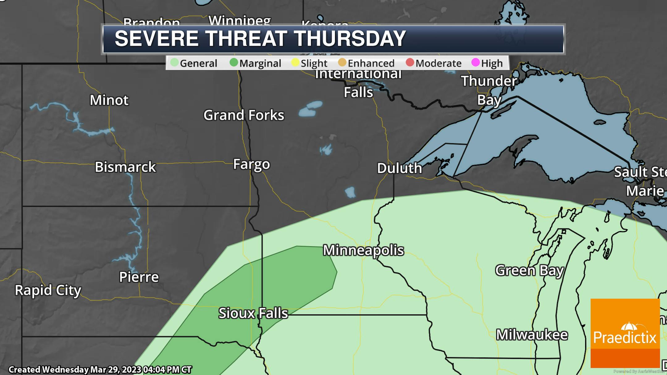
Meanwhile, a few storms in southwestern Minnesota Thursday Night could be on the strong side, capable of mainly large hail. A Marginal Risk of severe weather (threat level 1 of 5) is in place.

_______________________________________________

Closer Look At Thursday Across The Region

While it'll be a chilly start, with potentially more sun than clouds in the early morning hours, clouds will quickly increase and we'll start to see precipitation chances in the midday to afternoon hours. This is likely to begin as some light snow or flurries before changing over to rain as temperatures climb into the upper 30s to around 40F.

If you want to make sure you see dry conditions on Thursday - head to the northwest corner of the state! That is also where it'll be the chilliest, with highs only in the upper 20s. Highs in southern parts of the state will make it to the 40s.

_______________________________________________

First 50F Of 2023 Possible This Weekend

Friday: We'll still be dealing with that system impacting the region, bringing rain and eventually snow to the metro into the overnight hours. Winds will also be strong, with gusts of 35-45 mph possible.

Saturday: Any remaining snow showers should quickly end in the morning hours, with sunny skies by the afternoon. It'll continue to be chilly for April Fools Day, with highs only in the upper 30s.

Sunday: Cloudier skies will be around Sunday, with a very slight chance of a rain or snow shower in the morning hours. However, we could see the first 50F of the year during the afternoon hours with breezy south winds gusting to 25 mph.

_______________________________________________

More Precipitation Next Week?

Six-hour precipitation between 7 AM Tuesday and 7 AM next Thursday.

While it's too early for details (let's get past the end of the week system first!) we could be watching another potent system across at least parts of the state next week. To paraphrase Lamb Chop and Charlie Horse, "This is the winter that doesn't end, yes it goes on and on my friends..."

_______________________________________________

Slushy Travel Increasingly Likely Friday Night
By Paul Douglas

Well look at the bright side: chilly temperatures and a lack of heavy rain have created a best-case scenario for melting snow. It has been a slow-motion meltdown across the Upper Midwest, helping to lower the risk of river flooding later in April. I'm glad there's an upside to a chilly spring. It's getting harder to find silver linings.

1991-2020 data confirms that the average daytime high temperature in the Twin Cities hits 50F on April 1, and MSP may still enjoy the first 50 of 2023 Sunday afternoon. Now, about those driveway stakes which you should leave in place.

A storm tracking from Denver to Madison arrives with a rain later today into Friday, ending as wet snow Friday night. After dark the snow will stick, and some 2-5" amounts are possible by Saturday morning. After vague hints of spring on Sunday the next (stronger) system approaches with windswept rain next Tuesday. More plowable snow falls north/west of MSP by midweek.

Sunny and upper 30s for the Twins Home Opener in one week? Ouch.

_______________________________________________

Paul's Extended Twin Cities Forecast

THURSDAY: Flurries change to rain. Wake up 14. High 41. Chance of precipitation 90%. Wind SE 10-20 mph.

FRIDAY: Rain changes to snow. 2-5" at night. Wake up 34. High 36. Chance of precipitation 100%. Wind NE 15-30 mph.

SATURDAY: Flurries taper, the sun comes out. Wake up 23. High 37. Chance of precipitation 30%. Wind NW 10-15 mph.

SUNDAY: Mostly cloudy and milder. Wake up 30. High 48. Chance of precipitation 10%. Wind SW 10-15 mph.

MONDAY: Clouds linger. Wake up 29. High 42. Chance of precipitation 20%. Wind N 5-10 mph.

TUESDAY: Metro rain. Snow/ice up north. Windy. Wake up 34. High 39. Chance of precipitation 90%. Wind E 20-40 mph.

WEDNESDAY: Light snow or flurries. Wake up 31. High 35. Chance of precipitation 80%. Wind NW 15-25 mph.

_______________________________________________

Minneapolis Weather Almanac And Sun Data
March 30th

*Length Of Day: 12 hours, 40 minutes, and 20 seconds
*Daylight GAINED Since Yesterday: 3 minutes and 8 seconds

*When do we see 13 Hours of Daylight?: April 6th (13 hours, 2 minutes, 7 seconds)
*When Is The Sunrise At/Before 6:30 AM? April 14th (6:30 AM)
*When Is The Sunset At/After 8 PM? April 17th (8:00 PM)

_______________________________________________

This Day in Weather History
March 30th

1938: Springtime flooding hits Warroad and Grand Marais.

_______________________________________________

National Weather Forecast

A messy weather map is in place across a good portion of the nation on Thursday, with storms, icing, and snow possible. The area with the expected driest weather? The east coast!

Heavy snowfall of several inches (maybe even a foot in the mountains) will be possible from the western United States into the Upper Midwest through the end of the week. An inch or two of rain could fall along the west coast and in the central United States.

Skipping ahead to Friday, a widespread severe weather outbreak is possible across the Mississippi Valley, where an Enhanced Risk of severe weather (threat level 3 of 5) is in place. We will somewhat see two areas of severe storm activity to watch:

  • Iowa/Missouri into the Ohio Valley: Storms are expected to form in the midday to afternoon hours on Friday near the area of low pressure and along the cold front. These storms will be fast-moving and initially capable of significant wind gusts and several tornadoes. As storms move east, they will likely form into a line by the late afternoon/evening hours, capable of damaging winds and embedded tornadoes.
  • Mid-South: Storms that develop during the mid/late afternoon hours and persist into the evening and overnight hours will be capable of all severe weather hazards (hail, wind, tornadoes). There is expected to be a mix of individual and linear storms.

_______________________________________________

Crucial Antarctic ocean circulation heading for collapse if planet-warming pollution remains high, scientists warn

More from CNN: "Melting ice in the Antarctic is not just raising sea levels but slowing down the circulation of deep ocean water with vast implications for the global climate and for marine life, a new study warns. Led by scientists from the University of New South Wales and published Wednesday in the journal Nature, the peer-reviewed study modeled the impact of melting Antarctic ice on deep ocean currents that work to flush nutrients from the sea floor to fish near the surface. Three years of computer modeling found the Antarctic overturning circulation ā€“ also known as abyssal ocean overturning ā€“ is on track to slow 42% by 2050 if the world continues to burn fossil fuels and produce high levels of planet-heating pollution."

US renewable power surged ahead of coal for the first time last year

More from Grist: "Last year, U.S. renewable electricity generation surpassed coal for the first time, according to newly released federal data. The report marks a major milestone in the transition to clean energy, but experts say that much faster progress is needed to reach international climate targets. According to the Energy Information Administration, a federal statistical agency, combined wind and solar generation increased from 12 percent of national power production in 2021 to 14 percent in 2022. Hydropower, biomass, and geothermal added another 7 percent ā€” for a total share of 21 percent renewables last year. The figure narrowly exceeded coal's 20 percent share of electricity generation, which fell from 23 percent in 2021. The growth in renewable electricity was largely driven by a surge in added wind and solar capacity, the agency said."

UN sends question of countries' climate responsibilities to The Hague

More from Axios: "In a landmark though limited move, the UN General Assembly voted Wednesday to seek an advisory opinion on climate change from the International Court of Justice at The Hague. Why it matters: The resolution, sponsored by the climate-vulnerable nation of Vanuatu, could establish countries' obligations to act on climate change. Zoom in: In a speech on Wednesday backing Vanuatu's effort to pass the resolution, UN Secretary-General AntĆ³nio Guterres said: "Advisory opinions can provide much-needed clarification on existing international legal obligations.""

_______________________________________________

Follow me on:

Thanks for checking in and have a great day!

- D.J. Kayser