9 state parks and recreation areas where you can escape big crowds

August 23, 2025
A footbridge crosses Pike Creek near the start of the Big Loop Trail at Charles A. Lindbergh State Park in Little Falls. (Aaron Lavinsky/The Minnesota Star Tribune)

From vast prairies to rare fishing holes, here are a variety of lesser-known state parks and recreation areas to visit this summer.

The Minnesota Star Tribune

Good luck finding solitude at the best-known Minnesota state parks on a summer weekend. There are the people trying to find the perfect photo, the constant stopping to allow others to pass on a narrow trail and — among the worst offenders — self-proclaimed DJs blaring their music.

Some of the most popular are Gooseberry Falls State Park, which drew 758,400 visitors last year, and Fort Snelling State Park, which recorded 480,159 visitors.

We asked state parks insiders like Doug Ohman, host of PBS’ “Landmarks” series, how to get away from the big crowds.

For a project with the Minnesota Historical Society, Ohman visited every one of the state’s 64 parks. Some of the best are in little-known forests up north or in the prairies of southwestern Minnesota, he said.

“The hidden gems are off the beaten path. You either have to stumble upon them or find them by talking to state park staff,” Ohman said. “By doing some research, you’ll find yourself in some really great state parks.”

In addition to Minnesota’s state parks, there are nine recreation areas with trails that allow motorized recreational vehicles. State parks prohibit all off-highway motorized vehicles except snowmobiles.

Here are some favorites we’ve tracked down:
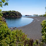
Northern Minnesota

Savanna Portage State Park was established to preserve a historic 6-mile portage connecting the Mississippi River and Lake Superior watersheds. (Minnesota Department of Natural Resources)

Hike along a historic trail at Savanna Portage State Park

Address: 55626 Lake Place, McGregor

What to expect: The Continental Divide goes through the park with water on the west side flowing into the Mississippi River and Lake Superior on the east side. Encompassing almost 16,000 acres, Savanna Portage State Park has 22 miles of hiking trails. The four lakes at the park prohibit gas-motored boats, which makes the park especially serene to walk around, Ohman said.

The gem: The historic canoe portage trail is about 6.3 miles one way. In the past, it was used by Dakota, Ojibwe and European people to travel between the Mississippi River and St. Louis River waterways. The trail starts near the West Savanna River (which empties into the Mississippi River) off Lake Place and ends at the East Savanna River (which empties into Lake Superior). The park was created in 1961 to preserve the trail, which goes through marsh, swamp and forest lands, according to the Minnesota Department of Natural Resources (DNR).

“Everyone should walk it,” Ohman said. “It is a piece of American history.”

Click here for map and park information.

The Challenge Trail in the La Salle State Recreation Area courses through a diversity of habitats. (Courtesy of Itasca State Park)

Swim at La Salle Lake State Recreation Area

Address: 10221 County 9, Solway

What to expect: Not too far from the Mississippi headwaters, La Salle Lake State Recreation Area is overshadowed by the much more popular Itasca State Park. Itasca, which recorded about 530,000 visitors last year, is the state’s oldest park. La Salle recorded just 23,000 visitors last year, according to DNR spokesperson Sara Berhow. The recreation area was established in 2011 and is just north of the park.

It features dramatic elevation changes made from glaciers. Though in a remote area, the park has Wi-Fi, bathrooms with showers and a campground.

The gem: La Salle Lake is one of Minnesota’s most pristine, according to the DNR. It is also one of the state’s deepest at 213 feet and stretches 221 acres. There is a canoe and kayak access point from La Salle Creek. Fish in the lake include walleye, northern pike and largemouth bass.

Click here for map and park information.

Central Minnesota

Lindsey Kielty, left, and her mother, Chrissy Kielty, of Excelsior, paddled back to shore after an evening paddle-board ride on Huntington-Feigh Mine Lake Monday night.
Lindsey Kielty, left, and her mother, Chrissy Kielty, of Excelsior paddle back to shore on Huntington-Feigh Mine Lake in June 2021. (The Minnesota Star Tribune)

Paddle at Cuyuna Country State Recreation Area

Address: 307 3rd St., Ironton

What to expect: Minnesota’s newest recreation area was formerly a region of iron mines. The Mahnomen Mine provided raw materials for World War II and closed in the 1960s. Over time, water filled in the pits creating crystal clear lakes, according to the DNR.

The gem: Cuyuna State Recreation Area is known for its mountain biking, but far fewer people paddle the park’s lakes. Pennington Mine Lake and Huntington-Feigh Mine Lake are the most accessible paddles from the main parking lot. Off the latter, a portage route goes to Alstead Mine Lake. Another gem: Mahnomen, Arco and Alstead Lake, named for three adjacent mine pits that have since filled in with water. At 525 feet, it is the deepest lake fully within Minnesota.

Click here for map and park information.

A footbridge across Pike Creek on the Big Loop Trail at Charles A. Lindbergh State Park in Little Falls. (Aaron Lavinsky/The Minnesota Star Tribune)

See three major biomes at Charles A. Lindbergh State Park

Address: 1615 Lindbergh Drive S., Little Falls

What to expect: The state park has a wider diversity of flora and fauna than many others, according to Doug Veeder, natural resources technician at the park. It is a meeting point of Minnesota’s three major biomes: pine, prairie and hardwood.

“While other parks struggle to replace the white pines lost to logging, they grow like weeds here, and some red pines in the park are over 120 years old,” he said. “The campground is fairly wooded, so people frequently comment that they feel like they are up north despite being in the middle of corn country.”

The area has four museums, including the Charles Lindbergh House and Museum and the Weyerhaeuser Museum. The Minnesota Fishing Museum is 2 miles north of the park, and Camp Ripley, which has a military museum, is 7 miles north of the park.

The gem: Take the Big Loop Trail to the spot where Charles A. Lindbergh Jr. landed his airplane, named Jenny, in 1923. The trail is flat with mowed grass, starts at the parking lot and is about 2.5 miles long. Along the way hikers will see views of the Mississippi River and Pike Creek.

Click here for map and park information.

Larry Bostrom and his golden retriever, Buddy, enjoy the fall colors and Wolf Creek Falls at Banning State Park. (Brian Peterson/The Minnesota Star Tribune)

Visit Wolf Creek Falls at Banning State Park

Address: 61101 Banning Park Road, Sandstone

What to expect: Kayakers and whitewater canoeists are often seen paddling down the Kettle River, which is one of the most challenging whitewater experiences in the state, according to the DNR. Walking paths run along the river, and there are remnants of historic sandstone quarry operations along the trails with informational signs.

The gem: Most people visiting Banning State Park hike south from the parking lot along the Kettle River to Hell’s Gate and then turn back. They miss the park’s best feature: Wolf Creek Falls, Ohman said.

“This has got a very tranquil flow to it when I’ve seen it,” he said. “What I like about it is that nobody’s there. It’s almost like you’ve discovered it for the first time.”

Take the Quarry Loop Trail, which starts at the parking lot. Then take Deadman’s Trail to High Bluff Trail. The waterfall is at the end of the trail. The trek is about 1.5 miles.

Click here for map and park information.

Southeastern Minnesota

Views at John A. Latsch State Park of the Mississippi River Valley.
The views at John A. Latsch State Park of the Mississippi River Valley. (The Minnesota Star Tribune)

Soak in the Mississippi River views at John A. Latsch State Park

Address: Latsch Park Road, Minnesota City

What to expect: John A. Latsch State Park is a 450-acre preserve that features three rocky bluffs that were used as landmarks by steamboat captains navigating the Mississippi River, according to the DNR. It was classified as a state scenic wayside and today is the only state park that does not require a state park permit. It is a day use park and no camping is allowed.

The gem: Take Riverview Trail up to Mount Charity Overlook, which rises more than 500 feet above the river, giving views of the bluffs, prairie, floodplain and oak forests. The trail is about a half-mile and includes a trek up 592 steps.

Click here for map and park information.

4stattr0610.217130.jpg
The cemetery in Forestville State Park has graves from the town's early pioneer days. (The Minnesota Star Tribune)

Hike to the cemetery of a ghost town at Forestville/Mystery Cave State Park

Address: 21071 County Rd. 118, Preston

What to expect: Forestville State Park is well known for its popular Mystery Cave tours that offer views of stalactites, dripstone formations and underground Turquoise Lake. The cave is the longest in Minnesota, according to the DNR.

The gem: Hike to Zumbro Hill Cemetery. The graveyard was forgotten until the state park was established in 1963, according to the DNR. It contains burials from the 1850s. From the parking lot, Zumbro Hill Cemetery is about a 2.5 mile trek. Start at Sandbank Trail, to Sugar Camp Hollow Trail and then up Cemetery Trail.

“There’s great trout streams and old growth trees,” said Chris Ingebretsen, manager of Blue Mounds and Split Rock Creek State Park. Ingebretsen has been to every state park but one. “They have fantastic forest and limestone bluffs that are really incredible to hike through.”

Click here for map and park information.

Southwestern Minnesota

The Bison at Blue Mounds State Park wallow in a dust bowl to keep cool and rid themselves of pesky bugs during the hot summer months.
The bison at Blue Mounds State Park wallow in a dust bowl to keep cool and rid themselves of bugs during the hot summer months. (Brian Peterson/The Minnesota Star Tribune)

Watch bison at Blue Mounds State Park

Address: 1410 161st St., Luverne

What to expect: Blue Mounds State Park gets quite a bit of traffic because of its proximity to Sioux Falls, Ingebretsen said. But for Minnesotans who live to the east and north, it’s not a well-known destination.

Highlights include the Upper Cliffline Trail that goes along the historic quarry with Sioux quartzite. Things that can’t be missed near the park include Touch the Sky Prairie, Brandenburg Gallery and Pipestone National Monument. Pipestone is one of two national monuments in Minnesota and is about 25 miles north of the state park.

The gem: The park features bison on a 533-acre pasture, and about 20 to 30 calves are born each spring, according to the DNR. It can be tricky to see the animals up close. There’s an observation deck and also the Western Loop Trail, which goes by the southwest corner of the range.

Another way to possibly see the animals is on a 90-minute tour.

Click here for map and park information.

On Cliffs Edge Trail, Blue Mounds State Park: TRAVELER; Charles Freiss, THE SCENE: Myself and brother Kenny were on a 3 plus days of photography in SW Minnesota. This scene is from the Upper Cliffs Edge Trail in Blue Mound State Park near Luverne,MN. on 0ct. 9, 2016.This location provided a great combination of fall colors in the reds of the foliage, golden yellows of the ripened corn and greens of the trees. This great vantage point on this trail shows the beauty of SW Minnesota. GOT THE SHOT;
Upper Cliffs Edge Trail in Blue Mound State Park offers a view of a great combination of fall colors. (The Minnesota Star Tribune)

Fish for trout at Camden State Park

Address: 1897 Camden Park Road, Lynd

What to expect: The spring-fed swimming pond was built by the Veterans Conservation Corps in 1935. Plus, there is a sand beach and bathhouse made from local stone, according to the DNR. The Redwood River runs through a cool forested valley in the park.

The gem: Hike the Dakota Valley Trail to an overlook of the Redwood River Valley. The 2.3-mile loop starts at the swimming pond and winds along the river.

“It’s a neat walk that showcases the different landscapes the park offers,” said Adam Kurtz, park supervisor at Camden State Park. “You go up on the prairie where it’s nice and open and then head back down to the river valley.”

Another gem: The Redwood River is stocked with trout, making it one of the only places in southwestern Minnesota that has the fish. Trout are usually found in southeastern Minnesota, Kurtz said.

Click here for map and park information.

about the writer

about the writer

Alex Chhith

Reporter

Alex Chhith is a general assignment reporter for the Minnesota Star Tribune.

See Moreicon

More from Outdoor Activities

See More
card image
Brian Peterson/The Minnesota Star Tribune

The last supermoon of the year will shine soon in December skies.

A barred owl on a tree branch in daylight.
card image