April Weather Summary So Far

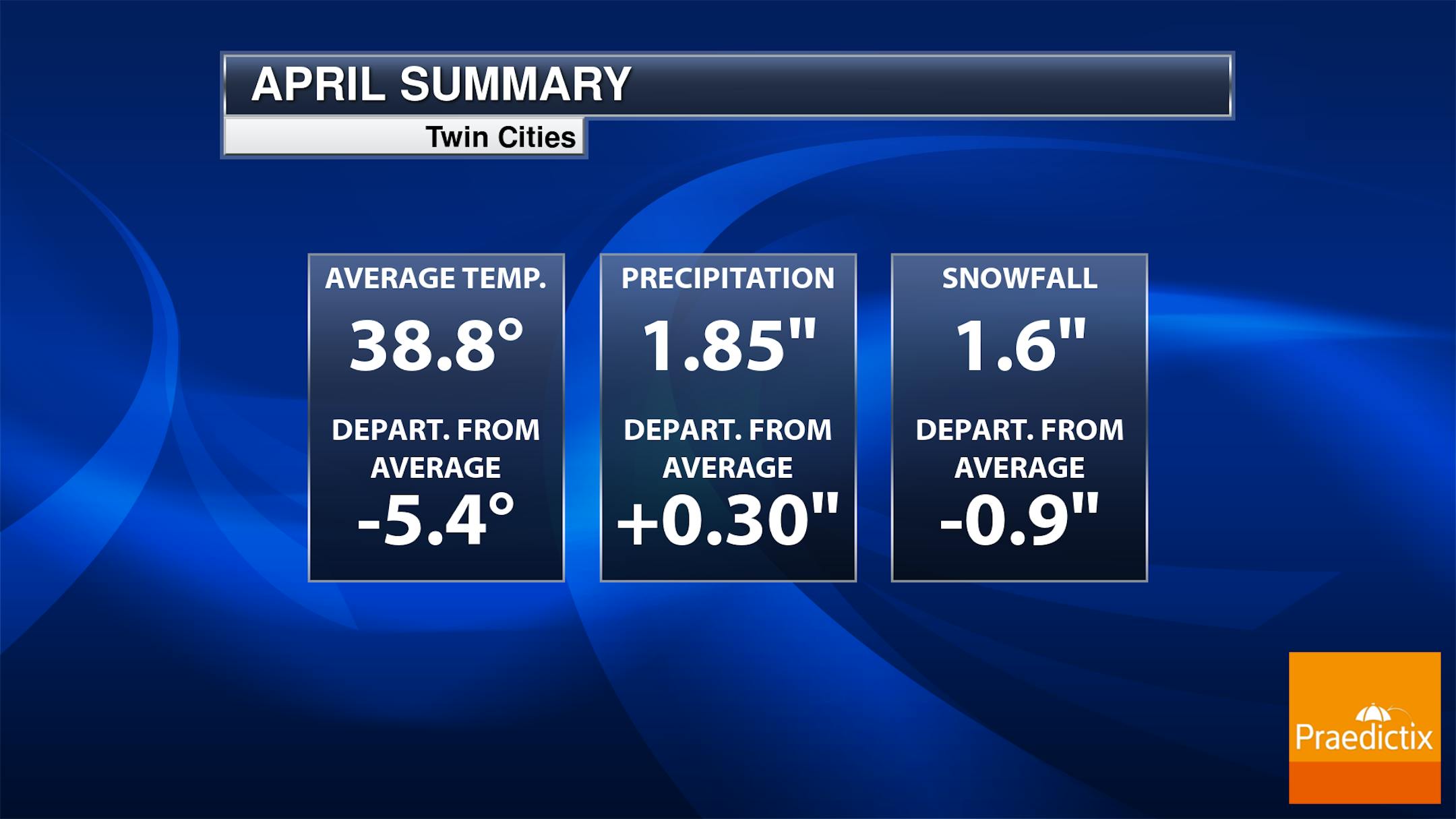
Here's the Twin Cities weather summary for April so far. Note that we're running nearly -5.5F below average so far this month, which is tied for the 32th coldest start to any April on record. We're about 0.30" of an inch above average in terms of precipitation, but nearly -1.0" below average in terms of snowfall.

Active Week of Weather

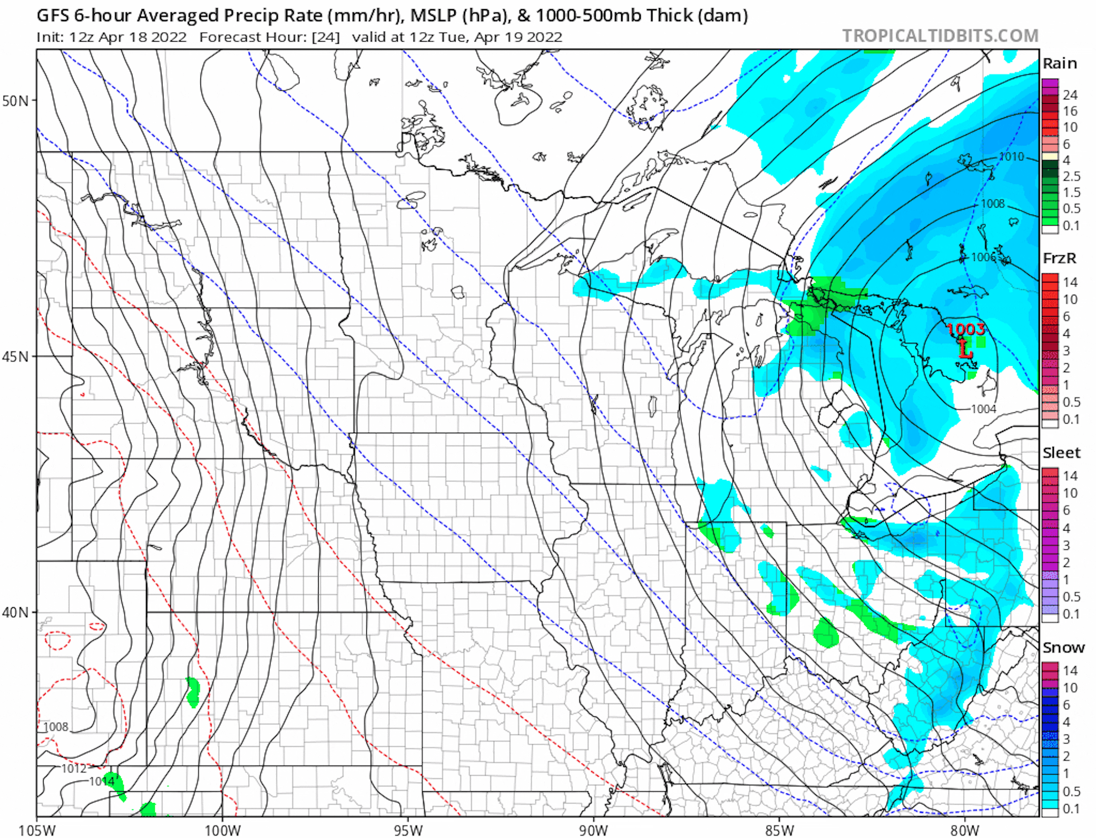
Here's the weather outlook from AM Tuesday to AM Monday. Thankfully, we'll have a break in the active weather through the first half of the day Tuesday. However, another storm system arrives PM Tuesday into Wednesday with widespread soaking rains and windy weather. The weather will be quiet again on Thursday before another large storm arrives Friday into the weekend with more rain and wind.

Precipitation Outlook

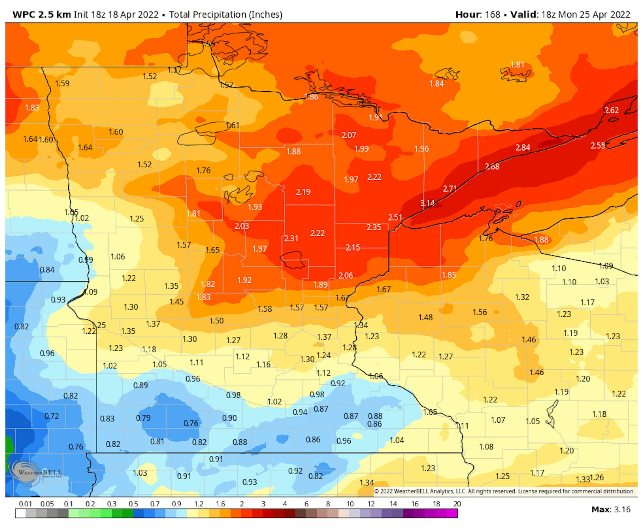
According to NOAA's WPC, the precipitation outlook through the weekend ahead looks pretty impressive with some 1" to 2" liquid tallies possible across the northern half of the state. Interestingly, some of the rain late week and into the weekend could be accompanied by thunder.

2022 Official Ice Out Dates

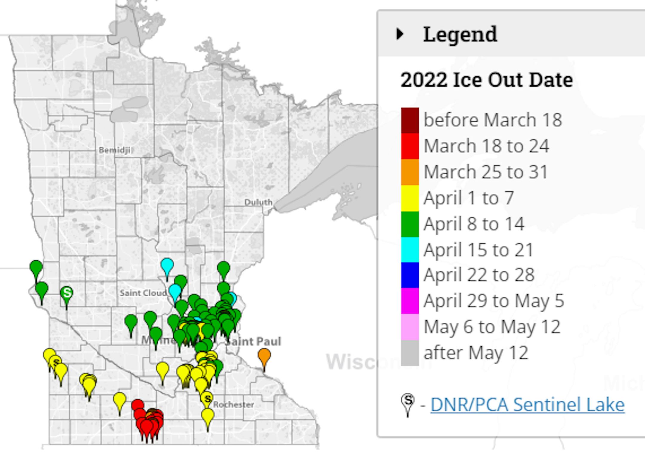
Hey - Look at that! More and more lakes are going ice out in the southern part of the state. However, thanks to a chillier than average month of April so far, several lakes are going out a little later than average. Cedar Lake, Lake Nokomis and Medicine Lake in the metro are officially out. According to the MN DNR, Lake Minnetonka went ice out on April 15th, 2 days later than normal (April 13th). Look for more ice outs over the coming days and weeks. It won't be long now before the land of 10,000 unfrozen lakes returns!

See the interactive map HERE:

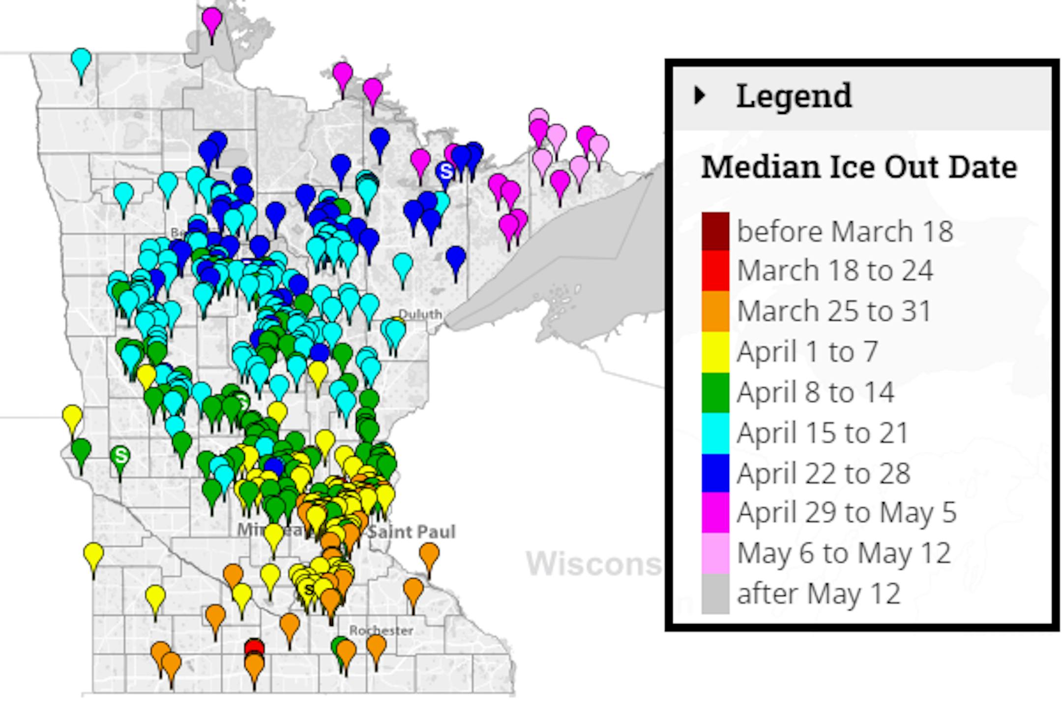
Average Ice Out Dates

We're still several weeks away from ice out across parts of the state, but according to the MN DNR, here's a look at the average ice out dates for lakes across the state. Note that some lakes across the southern part of the state typically see ice out around the end of March. Lake Minnetonka typically doesn't see ice out until mid April. A few lakes in far northern & northeastern MN don't see ice out until late April or early May.

See more from the MN DNR HERE:

Status of Spring

"April 18, 2022 - Spring leaf out continues to progress across the country. Our spring leaf anomaly compares the arrival of spring leaf out this year to a long-term average of 1991-2020. In the East, spring leaf out is patchy this year, arriving days to weeks late across much of the Southeast and Midwest, and arriving days to weeks early across the southern part of the Midwest, the Southern Appalachians, the mid-Atlantic, and the Northeast. Parts of Maine are over a week early. In western states, spring leaf out is also patchy, arriving a week late in some locations and over a month early in others. Parts of Montana and South Dakota are 2-3 weeks early. Spring bloom is also spreading north, arriving days to a week late in Texas and Florida and days to several weeks early in California. Spring bloom is over a week early in parts of Georgia, the Carolinas, and Virginia. The mid-Atlantic is patchy, several days early in some locations and several days late in others."

See more from NPN HERE:

Tuesday Weather Outlook

The weather outlook for Minneapolis on Tuesday shows brighter skies during the first half of the day with temps running well below average once again. The 2nd half of the day will be cloudier with areas of light rain or drizzle possible.

Meteograms for Minneapolis

The hourly temps for Minneapolis on Tuesday shows temperature readings starting in the upper 20s in the morning and warming into the mid 40s by the afternoon. Skies will be sunnier to start the day, but will be cloudier late with a chance of light rain or drizzle by the evening commute or later.

Weather Outlook on Tuesday

Temps around the region on Tuesday will be nearly -10F to -20F below average across much of the region. Enjoy the sunshine early in the day as there will be increasing clouds later in the day with a chance of isolated light rain showers or drizzle.

Extended Temperature Outlook For Minneapolis

The extended temperature outlook for Minneapolis through early next week, shows well below average temperatures through midweek. Readings will be nearly -10F to -15F below average through Wednesday, but we'll be back to near average readings by the end of the week and possibly nearing 70F by Saturday!

Extended Weather Outlook For Minneapolis

The extended weather outlook over the next 7 days shows chilly and active weather in place through midweek. Drier weather will be in place on Tuesday before another system arrives Wednesday with more rain. Late Friday into Saturday another system moves in with rain and thunder chances. Note that temps on Saturday could approach 70F in the metro, but it'll turn colder again Sunday and Monday with temps well below average once again.

Extended Temperature Outlook For Minneapolis

According to the ECMWF & GFS extended temperature outlook, temps will be quite chilly through the first half of the week. However, there's a nice warm up in place for the end of the week and weekend with temps at or above average for a change. Enjoy the brief warmup because it looks like we'll be below average once again by the end of the month and early May.

8 to 14 Day Temperature Outlook

According to NOAA's Climate Prediction Center, the 8 to 14 day temperature outlook shows warmer than average temps across across the southwestern US. Meanwhile, continued cooler than average temperatures will be found along the northern tier of the nation and east of the Rockies.

8 to 14 Day Precipitation Outlook

According to NOAA's Climate Prediction Center, the 8-14 Day precipitation outlook shows more active weather will be possible along the East Coast, but drier weather will settled in from the Midwest to the Southern & Southwestern US.

A Very Character-Building Spring
By Paul Douglas

A quick moment of silence for spring. Thankyou. Has anyone tried rebooting 2022? Better yet, an upgrade please. My Navy son shared terminology used by first year plebes at The Naval Academy: "Embrace the suck". That sounds about right. Gardening in the snow. Easter Egg hunts with kids in gloves and boots. A lone boater on the lake, an act of defiance amid whitecaps and wind chill. No more platitudes or promises. Spring is a bust - perhaps a warm October will compensate for a chilling April.

The sun reappears today with another surge of rain on Wednesday. Temperatures moderate as the week goes on with 50s by Thursday and Friday, and if the sun comes out: 70 possible Saturday with a dash of humidity and rumble of thunder. You know, "spring like"?

I keep waiting for sustained warmth, but we may have to wait a few more weeks for green lawns and sprouting tulips. New England is seeing a nor'easter today with heavy snow. The northern tier of the USA is a springy no-fly zone. It's true: misery loves company.

Extended Forecast

TUESDAY: Partly sunny. Winds: SE 7-12. High: 45.

TUESDAY NIGHT: Cloudy with a chance of rain or drizzle. Winds: SE 10-15. Low: 41.

WEDNESDAY: Rain likely, especially PM hours. Winds: S 10-20. High: 48.

THURSDAY: Plenty of sunshine, springy again. Winds: NW 8-13. Wake-up: 36. High: 56.

FRIDAY: Clouds increase, PM showers. Winds: SE 10-20. Wake-up: 40. High: 57.

SATURDAY: Some mild sun, few T-storms. Winds: S 15-35. Wake-up: 50. High: 70.

SUNDAY: Partly sunny, windy and cooler. Winds: SW 20-40. Wake-up: 44. High: 57.

MONDAY: Clouds, few sprinkles. Winds: NW 10-20. Wake-up: 37. High: 41.

This Day in Weather History

April 19th

1928: Chilly air moves across the region with a record low of 19 at the Twin Cities.

1893: A heavy snowstorm at Bird Island would last until the 21st. 17 inches of snow would fall, with drifts 3 to 4 feet high.

1820: The first tornado ever reported in Minnesota hits the camp that would soon become Ft. Snelling. It damages the roof of a barracks, with no one injured.

Average High/Low for Minneapolis

April 19th

Average High: 60F (Record: 87F set in 1985)

Average Low: 39F (Record: 19F set in 1928)

Record Rainfall: 1.28" set in 1871

Record Snowfall: 1.2" set in 1982

Sunrise/Sunset Times for Minneapolis

April 19th

Sunrise: 6:20am

Sunset: 8:03pm

Hours of Daylight: ~13 hours & 42 minutes

Daylight GAINED since yesterday: ~ 2 minute & 57 seconds

Daylight GAINED since Winter Solstice (December 21st): ~ 4 Hour & 56 Minutes

Moon Phase for April 19th at Midnight

3.2 Days Before Last Quarter Moon

See more from Space.com HERE:

National High Temps Tuesday

The weather outlook on Tuesday shows chilly temps along and east of the Mississippi River with highs running nearly -10F to -15F below average. Meanwhile, it'll be quite a bit above average along the Front Range and through parts of the Southwest, where temps will be quite a bit above average.

National Weather Outlook

Here's the national weather outlook through midweek. Areas of heavy snow will continue across parts of the Great Lakes and Northeast, while another storm system takes shape in the Central US with more rain/thunder. There is also another storm system in the Pacific Northwest and will develop over the Western US during the 2nd half of the week.

Extended Precipitation Outlook

According to NOAA's Weather Prediction Center, areas of heavier precipitation will be found east of the Rockies. Several inches of rain maybe possible in the Central US, where widespread showers and storms will be possible Friday and into the weekend.

Extended Snowfall Outlook

Here's the ECMWF extended snowfall outlook through next week. Areas of heavy snow will be possible across parts of the northern tier of the nation. The heaviest will be found in the high elevations in the western US as well and parts of the Midwest and Northeast.

Climate Stories

"The Wild, Uncertain Future of Carbon Dioxide Removal"

"A group of powerful companies on Monday announced a new venture to suck carbon dioxide out of the atmosphere. Meta, Alphabet, Stripe, Shopify, and McKinsey are pledging together to buy $925 million worth of carbon removal over the next nine years, a move they say will create a market that will help develop needed technologies to get CO2 out of the air and the ocean. "Recent reports from the Intergovernmental Panel on Climate Change make clear there is currently no pathway to keeping global temperature increases within 1.5°C without permanently removing gigatons of CO₂ already present in the atmosphere and ocean," the release reads, adding that the move will send a "strong demand signal to researchers, entrepreneurs, and investors that there is a market for carbon removal."

See more from Gizmodo HERE:

"Understanding why our giant glaciers disappeared in the past gives clues to the future"

"An international team of climate scientists is working in North Canterbury to try to understand the reasons why giant glaciers disappeared thousands of years ago. Massive pre-historic glaciers once stood on the banks of Lake Tennyson, North Canterbury. But they no longer exist today. As glaciers retreat, they leave behind clues to their age in the form of sediment and boulders dropped by the ice as it melts. Called moraines, these piles of debris give us critical insights into Aotearoa New Zealand's climate history. Researchers from NIWA, Victoria University of Wellington, University of Maine, Lincoln University and GNS Science are studying the moraines around Lake Tennyson to work out why and when the glaciers disappeared. Climate scientist Dr. Andrew Lorrey is leading the work for NIWA. "We need to understand the changes that we see in this landscape that happened millennia ago, because from the chronologies that are emerging, it looks like this landscape changed really, really fast."

See more from Phys.org HERE:

"Bumpy flight? Here's how clouds affect air travel"

"Bumpy flight: Clouds and air travel Sure, there's clear-air turbulence. But when your airplane ride gets bumpy, you're likely to look out your window and see clouds. They might range from puffy cumulus clouds, aka fair-weather clouds, to monstrous cumulonimbus with their characteristic anvil-shaped tops, billowing sides and ominously dark bases. The fact is … clouds are cooler than the surrounding air. So it's the contrast in density between clouds and the surrounding air that creates a sort of "pothole" in the sky, making for a less smooth ride. Weather and aircraft performance Mike Sueflohn has been a private and commercial pilot for more than 23 years. As a pilot, he must take part in recurrent training, where they discuss how weather relates to aircraft performance. Some of the issues they focus on are takeoffs, landings and concerns such as wind shear. Sueflohn told EarthSky: Much of the weather, including turbulence, that we have when flying is derived by the sun and uneven heating of Earth's surface. As a result, you can experience turbulence at any time. Normally, early in the morning and later in the evening and throughout the night you may find the best time for smooth rides."

See more from Earth Sky HERE:

Thanks for checking in and don't forget to follow me on Twitter @TNelsonWX