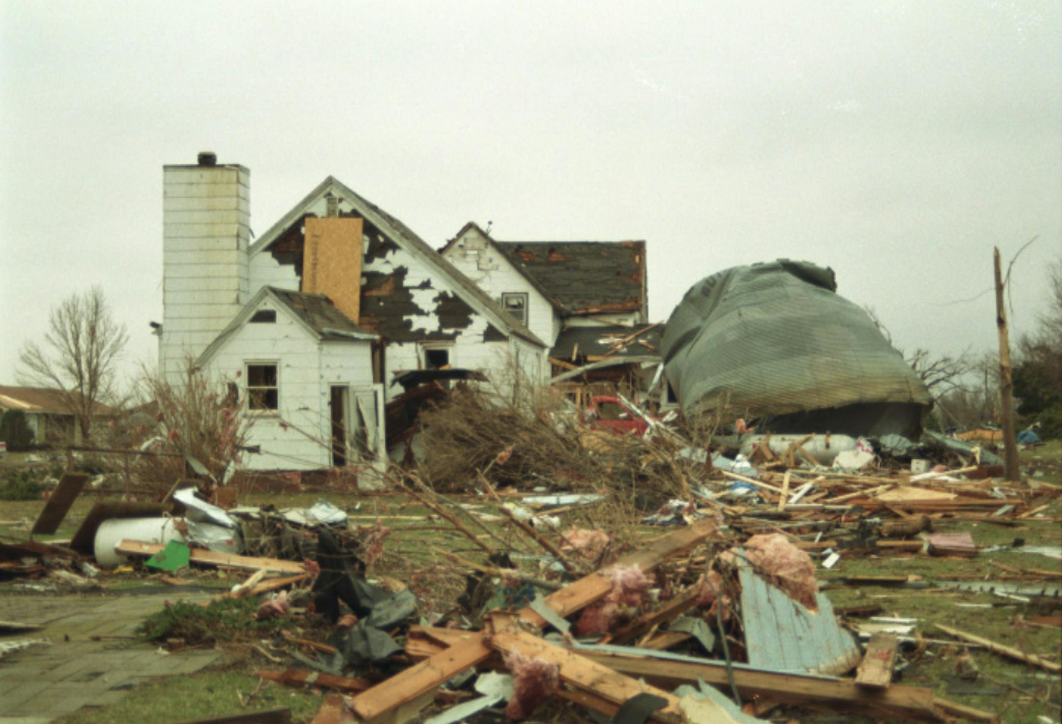
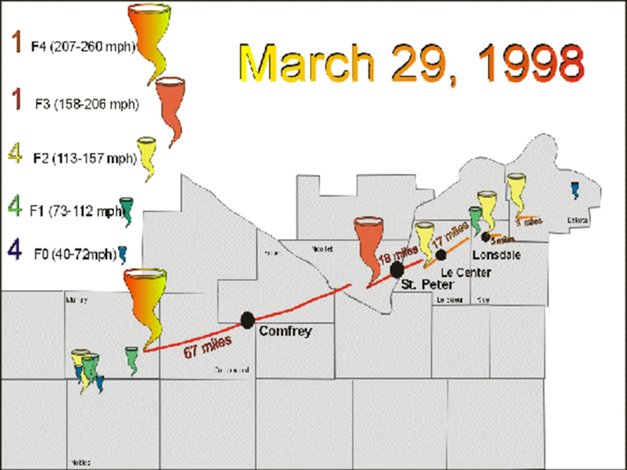
"25 Years Later: The March 29, 1998 Tornadoes (including Comfrey, St Peter, and Le Center)"

Multiple tornadoes tracked along a warm front in southern Minnesota during the late afternoon and early evening of March 29, 1998. With a total of 14 tornadoes, it was the largest March occurrence of tornadoes in Minnesota. In fact, prior to 1998, there were only 7 tornadoes known to have hit Minnesota in March. There was extreme and widespread damage to trees, homes, schools, and businesses. Massive hail accompanied the storm, with golf ball to baseball size hail common. The largest hail stone fell in Courtland and was 4.5 inches in diameter. The tornadoes tracked along a warm front draped across southern Minnesota. Sadly, two people were killed by the tornadoes: an 85 year old man near Lake Hanska, Louis Mosenden, and a 6 year old boy, Dustin Schneider, near St. Peter.

"25 years after tornadoes tumbled southern Minnesota, residents still carry the lessons learned"

"On March 29, 1998, Lynette Nyman, just three months into her job as a St. Peter-based MPR News reporter received a quick visit from a fellow journalist. "Just as she was leaving, she's like, 'Oh, well take care. You know, have fun!' Nyman remembers. And then Nyman responded in a way she will never forget."'Oh, no nothing ever happens here.' I literally said those words," she said. "Nothing ever happens here. And then, just after five o'clock, everything changed." Fourteen tornadoes swept through the region. The worst damage was in Comfrey and the Lake Hanska area. In St. Peter, an F-3 tornado destroyed more than 200 homes. It tore up trees and flattened schools and businesses."

See more from MPR News HERE:

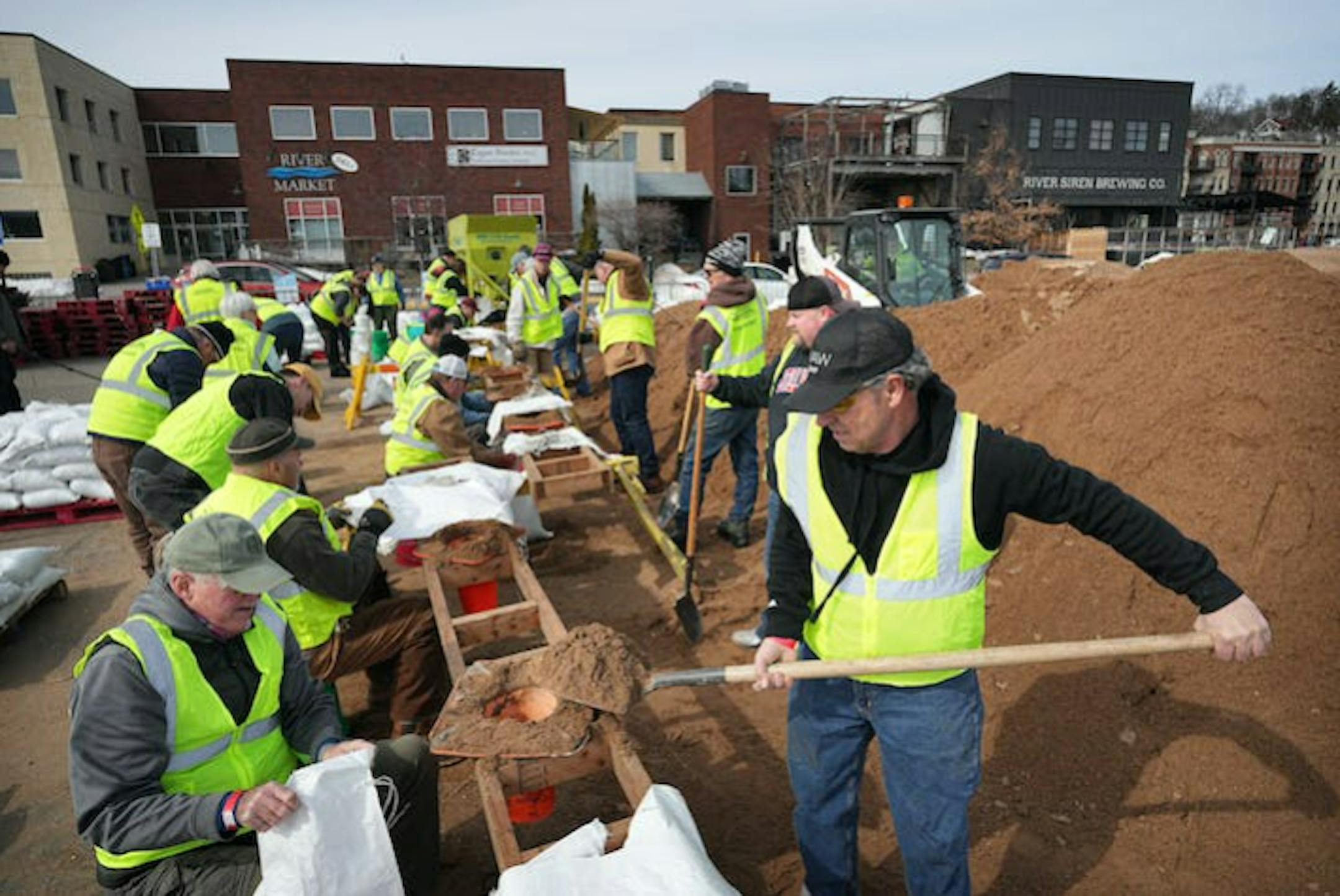
"Stillwater braces for what could be historic spring flooding"

"Volunteers are expected to fill thousands of sandbags to protect the town as the St. Croix River crests. Volunteers wearing high-visibility vests hoisted bag after bag of sand onto pallets in downtown Stillwater Monday morning, the first day of a weeklong effort to build a town-saving berm ahead of what could be a historic crest of the St. Croix River. Triggered by warnings from the National Weather Service, which for weeks has forecast a high probability of flooding after one of the snowiest winters on record, the two dozen volunteers worked through a sunny but chilly morning in a riverside parking lot closed last week in preparation for the flood fight. "You have to pace yourself," said Leesa Levy, a new Stillwater resident who said she wanted to help out. "It's nice to be able to give back to the city," said Doug Menikheim, who lives on Stillwater's South Hill. "It's a nice place to live." Stillwater Public Works Director Shawn Sanders said it's too soon to know what the berm will cost the city, or exactly when or how high the river will crest. Many years the St. Croix hit its peak in the second week of April, he said, but the cooler temperatures of the past few weeks could mean it crests late."

See more from StarTribune HERE:

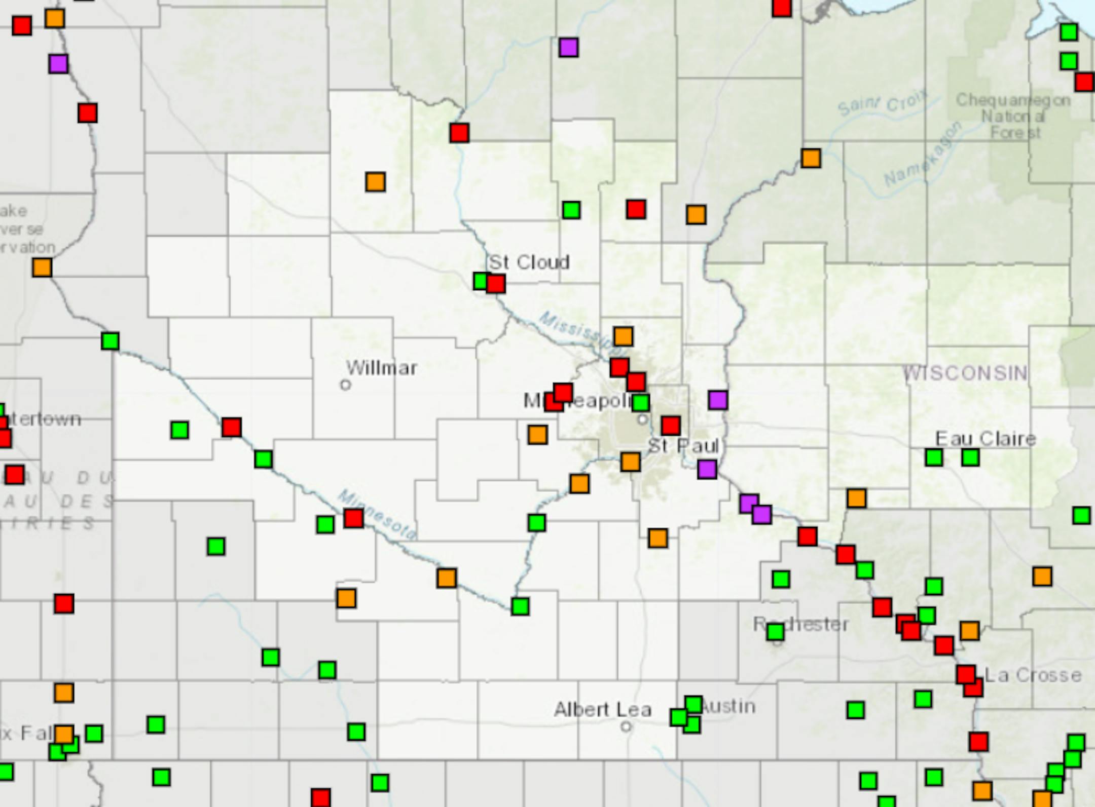
Spring Flood Outlook

"No real changes in the last two weeks... The late March updated outlook for spring flooding in the upper Mississippi, Minnesota, and Chippewa River basins remains well above normal, particularly on the Mississippi from St. Paul downstream. The very high snowpack for this time of year has remained in place over the last two weeks. There is some good news! The 7-10 day temperature and precipitation pattern is favorable for a slow melting period through the end of March (details later in the briefing). As always, the threat of seeing major flooding will still depend on what kind of rainfall/temperature patterns we get as we move into April."

See more from the NWS Twin Cities HERE:

9th Longest Stretch of at Least 1" Snow Depth at MSP

"The streak for number days in a row with at least 1 inch of snow on the ground at 6 AM CST/7 AM CDT ended at MSP on March 25. The streak began November 30 after the first major snowstorm of the season. A lack of prolonged warm air through winter and frequent snowstorms kept the streak going through late March. The 116 days ranks 9th longest such streak on record."

See more from the NWS HERE:

Snow Depth

As of Monday, March 27th, the MSP Airport had a Trace of snow on the ground, which ended the 9th longest stretch of at least 1" snow on the ground. Much of Minnesota and into northern Wisconsin has a pretty significant snowpack. Nearly 2ft to 3ft of snow is on the ground near Lake Superior and more than 3ft on the ground near across parts of the U.P. of Michigan.

Snow Pack Water Equivalent

According to the National Weather Service, there is still a lot of water locked in the snow pack. SWE stands for Snow Water Equivalent and as you can see in the figure below, several inches of water is locked in the snow pack across much of the state. There is a little less around the Twin Cities (2.2"), while the heaviest is located closer to Lake Superior.

8th Snowiest Season at MSP

With more than 81" of snow, the MSP Airport is currently sitting at the 8th snowiest winter on record! We need less than 4" of additional snow to get into the top 5, but would need almost an additional 18" to get to the top spot.

Seasonal Snowfall

Many locations are nearly 2ft to 3ft above average snowfall for the season from Sioux Falls to the Twin Cities and north toward Duluth. MSP was sitting at 81.2" of snow for the season (since July 1st), which is the 7th snowiest start to any season on record and nearly 47" above average. Duluth has seen 125" of snow this season and the snowiest start to any season on record there and the 6th snowiest season on record.

The Illusive 50F For Minneapolis

According to the Twin Cities National Weather Service, we have not yet hit 50F this March. If we fail to do so, this will be the first time we haven't hit 50F in March since 2001.

Extended Temperature Outlook

The NBM extended temperature outlook for Minneapolis shows a string of 30s and 40s through the end of the month and into early April. Interestingly, the last time we hit 50F or warmer was back on November 26th (53F). On average, we hit our first 50F on March 4th. Last year, we hit our first 50F on March 15th (51F). There is a chance that we could see our first 50F at some point in early April.

Twin Cities Weather Outlook For Wednesday

The weather outlook for the Twin Cities on Wednesday, March 29th will be MUCH cooler than average with highs only warming to around 30F. Skies will generally be sunny for much of the day with feels like temps that will be well below average.

Weather Outlook on Wednesday

Temps across the region on Wednesday will warm into the 10s and 20s across much of the state, which will be around -15F to -25F below average. The Twin Cities will warm to around 30F, which will still be well below average. We'll also see more sunshine than we did Tuesday afternoon.

Meteograms For Minneapolis

The hourly temps through the day Wednesday will start in the low/mid 10s in the morning and will warm to around 30F by the afternoon. It'll be a mostly sunny day with just a few clouds from time to time. Northwesterly winds will be a little breezy throughout much of the day with gusts around 15mph, making it feel quite chilly for late March.

Hourly Feels Like Temps

Feels like temps on Wednesday will start around 0F and very cold for this time of the year. Feels like temps by the afternoon may warm to around 20F, again still very chilly for late March.

Status of Spring

"March 20, 2023 - Spring leaf out continues to spread north, arriving several days to weeks earlier than average (the period of 1991-2020) in much of the Southeast, lower Midwest, and mid-Atlantic. PIttsburgh, PA is 17 days early. Parts of SE Colorado and Kansas are days to a week late. The West is a mix of early and late. Southwest UT is days to over a week late and Portland, OR is 2 days late. Spring bloom has also arrived in southern states, days to weeks early in the Southeast, and days to over a week late in the Southwest. Nashville, TN is 25 days early, Las Vegas, NV is 8 days late. How typical is this year's spring? Darker colors represent springs that are unusually early or late in the long-term record. Gray indicates an average spring. Parts of the Southeast, lower Midwest, mid-Atlantic, and New York City area are seeing either the earliest spring leaf on record or a spring that only occurs once every 40 years (dark green). Parts of Arizona are seeing a spring that only occurs this late once every 40 years (purple). Spring bloom is latest on record across parts of the Southwest including California and Arizona, and earliest on record in parts of the upper Southeast including Tennessee, Georgia, South Carolina, and North Carolina."

See more from the National Phenology Network HERE:

Weather Outlook

It'll be a chilly Wednesday across the Midwest in the wake of a weak storm system that brought a little snow to the northern half of the state on Tuesday. Weather conditions will be quiet in the Midwest on Wednesday, but will turn more sour late week with a chance of showers and thunderstorms Thursday and Friday. Some of the storms in the Central US will be strong to severe with locally heavy rainfall. Meanwhile, areas of heavier snow will be possible across parts of the Upper Midwest and could be enough to shovel and plow for some.

Severe Threat on Thursday & Friday

Widely scattered showers and storms will develop in the Central and Southern US later this week, some of which could be strong to severe with locally heavy rains. The severe threat isn't super impressive on Thursday, but Friday could be fairly active. Stay tuned for more...

Extended Temperature Outlook For Minneapolis

Temps will warm into the 30s and low/mid 40s over the next few days with the coldest day on Wednesday as we only warm to around 30F. The warmest day will be Sunday as we get close to 50F, which would be the first 50F of the year and nearly a month behind the normal.

Extended Weather Outlook For Minneapolis

Weather conditions will be quiet and cold on Wednesday before a more impressive storm arrives in the Midwest late week. Areas of rain and thunder could turn to a wintry mix late Friday into early AM Saturday. Interestingly, the highs on Sunday could reach 50F, which would be the first 50F of the year.

8 to 14 Day Temperature Outlook

According to NOAA's Climate Prediction Center, the 8 to 14 day temperature outlook shows cooler than average temperatures across much of the Western US. Meanwhile, warmer than average temps will be in place across the Eastern US.

8 to 14 Day Precipitation Outlook

According to NOAA's Climate Prediction Center, the 8 to 14 Day precipitation outlook shows active weather continuing across much of the nation and especially across the Central and Southern US.

A Few More "Snow Events" On The Way
By Paul Douglas

Just like lutefisk sliders, a Minnesota spring is an acquired taste. So many years we go from slush to thunder in a day or two. Not this year.

Let me rip off the meteorological Band-Aid: Plowable snow is possible Friday night. It's early for specifics, but more than 3 or 4" of slush is possible. Most of that will melt by midday Saturday. And by Sunday a southwest breeze and sunshine may lure the mercury to 50F in the metro, for the first time since November 26. That would be nice, thank you very much.

In the meantime today feels like late February with blue sky and low 30s, if we're lucky. A much higher sun angle will almost make it feel tolerable.

The next system arrives with rain Thursday and Friday, and models are consistent with a changeover to snow Friday night. Heaviest snowfall amounts may stay south of MSP.

Twins Home Opener weather next Thursday? No comment. Rain Tuesday may end as windswept snow by Wednesday with slushy piles and a whiff of windchill at Target Field. I'm shocked. I hope I'm wrong.

Extended Forecast

WEDNESDAY: Chilled sunshine. Winds: NW 7-12. High 31.

WEDNESDAY NIGHT: Mostly clear and quiet. Winds: W 5. Low: 17.

THURSDAY: Metro rain, icy mix north of MSP. Winds: SE 10-20. High 39.

FRIDAY: Rain changes to snow. Few inches late? Winds: NE 15-30. Wake-up: 34. High 38.

SATURDAY: Becoming sunny and nicer. Winds: SW 5-10. Wake-up: 23. High: 36.

SUNDAY: Sunny, almost feels like spring! Winds: SW 10-15. Wake-up: 33. High: 50.

MONDAY: Rain arrives PM hours. Winds: E 10-20. Wake-up: 30. High: 46.

TUESDAY: Windy. Rain changes to snow. Winds: NE 20-40. Wake-up: 32. High: 42.

This Day in Weather History

March 29th

1986: Record warmth occurs with July-like temperatures. A monthly record high of 83 occurs at the Twin Cities.

Average High/Low for Minneapolis

March 29th

Average High: 48F (Record: 78F set in 1946)

Average Low: 30F (Record: -1F set in 1923)

Record Rainfall: 1.08" set in 1896

Record Snowfall: 6.5" set in 1894

Sunrise/Sunset Times for Minneapolis

March 28th

Sunrise: 7:00am

Sunset: 7:35pm

Hours of Daylight: ~12 hours & 34 minutes

Daylight GAINED since yesterday: +3 Minutes & 8 Seconds

Daylight GAINED since Winter Solstice (December 21st): ~ 3 hour & 48 minutes

Moon Phase for March 28th at Midnight

0.2 Days Since First Quarter Moon

National High Temps on Wednesday

Temperatures on Wednesday will be cooler than average across much of the nation with some of the coolest temps being found across the High Plains and the Midwest. A storm system in the Western US will continue to bring areas of heavy rain and snow to California.

National Weather Outlook Wednesday

The weather outlook on Wednesday will be unsettled across the Great Lakes and Northeast with areas of rain and snow. Meanwhile, a much larger storm system will impact the Western US with areas of heavy and and high elevation snow, especially in California.

National Weather Outlook

Weather conditions will be quieter across the Gulf Coast States on Wednesday after several days of severe storms and heavy rainfall. A much larger storm will impact the Western US on Wednesday and will begin moving into the Central US late week with widely scattered showers and storms, some of which will be strong to severe with locally heavy rain. Meanwhile, areas of heavy snow will move out of the Western US and into the Upper Midwest later this week.

Extended Precipitation Outlook

According to NOAA's Weather Prediction Center, the extended precipitation outlook shows heavier amounts from the Great Lakes and Midwest to the Ohio and Tennessee Valley. There will also be heavier precipitation in the Western US and especially in the high elevations.

Snowfall Potential

According to the ECMWF (European model), heavy snow will be found across much of the high elevations in the Western US and across the northern tier of the nation, possibly across parts of the Midwest! Stay tuned...

Climate Stories

"California Extreme Weather Is the New Normal"

California's bout of extreme wet weather could become the new normal as climate change worsens, a researcher has warned. A bomb cyclone battered the state on Tuesday, bringing down trees and power lines. At least one person was killed after a tree fell onto a vehicle, the Los Angeles Times reported. Early on Wednesday, more than 130,000 customers were still without power, according to PowerOutage.us. Tom Corringham, a research economist at Scripps Institution of Oceanography at UC San Diego, told Newsweek that California could expect more of these extreme weather patterns in the future as the climate warms.

See more from Newsweek HERE:

"U.N. warns of looming global water crisis. Here are some solutions"

"It's World Water Day and we live in a time and on a planet where access to safe drinking water is a fundamental human right. Cool, right? We also live on a planet where as many as 3.6 billion people experience water stress for at least a month each year. Leading up to the first United Nations water summit since 1977, a newly released U.N. World Water Development Report warns that humanity is walking a dangerous path toward losing its most precious resource due to "vampiric overconsumption and underdevelopment." The report states that the biggest causes for the water crisis are climate change and the increased industrial and urban demands, as well as the unsustainable management of the ever-expanding agriculture sector, which uses a staggering 70 percent of the world's freshwater supply."

See more from Mashable HERE:

"THE WEBB TELESCOPE IS SO POWERFUL, IT SPOTTED A DUST STORM ON A PLANET IN A DIFFERENT STAR SYSTEM"

"For the first time ever, a dust storm has been observed outside of our Solar System ā€” and naturally, it was the powerful James Webb Space Telescope that made the discovery. A press release on the Space Telescope Science Institute's Webb-site details the JWST-detected storm, which took place on exoplanet VHS 1256 b, a "massive brown dwarf" planet located about 40 lightyears from Earth. "Ever had hot sand whip across your face?" the press release quips. "That's a soothing experience compared to the volatile conditions discovered high in the atmosphere of planet VHS 1256 b." The JWST was able not only to observe the distant dust storm, but also to determine what its atmosphere is made of: "silicate particles, ranging from fine specks to small grains."

See more from Futurism HERE:

"Climate scientist echoes UN warning that 'humanity is on thin ice,' says previous predictions were not wrong"

"PBS Newshour" invited climate scientist Katharine Hayhoe to discuss climate change predictions following the release of the Intergovernmental Panel on Climate Change (IPCC) report on Monday. The IPCC, an organization of experts convened by the United Nations, published an extensive report warning about the disastrous effects that global warming predictions are expected to have on humanity by the early 2030s. Many social media users have called out these claims, pointing out that past climate doom predictions have been wrong for decades. However, Hayhoe insisted the predictions were not wrong and instead the "uncertainty" comes from humanity."

See more from Fox News HERE:

Thanks for checking in and don't forget to follow me on Twitter @TNelsonWX