Wednesday: 90F With Afternoon & Evening Severe Storms Possible - Blazing Hot This Weekend

A 90F day is expected Wednesday ahead of a cold front that'll spark severe storms in the PM hours. Wildfire smoke could move back in on Thursday before hot weather is expected this weekend with highs in the mid/upper 90s. - D.J. Kayser

August 16, 2023 at 12:00AM
(The Minnesota Star Tribune)

Northern Minnesota Air Quality Alert

(The Minnesota Star Tribune)

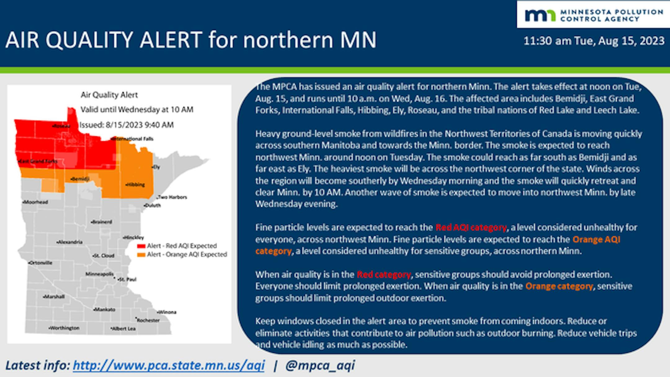
Due to Canadian wildfire smoke, an Air Quality Alert is in place across northern Minnesota through 10 AM Wednesday. In parts of northern Minnesota, the air will be unhealthy for everyone due to the wildfire smoke. While we will see this batch clear the state Wednesday morning, another round of smoke is expected to move into Minnesota on Thursday (more on that below).

_______________________________________________

Wednesday: 24th 90F - PM Severe Storm Risk

(The Minnesota Star Tribune)

Forecast loop between 1 PM Wednesday and 1 AM Thursday.

As we head into Wednesday afternoon and evening, a cold front will be moving across the state that is expected to spark a line of showers and thunderstorms. Some of these are expected to be severe.

(The Minnesota Star Tribune)

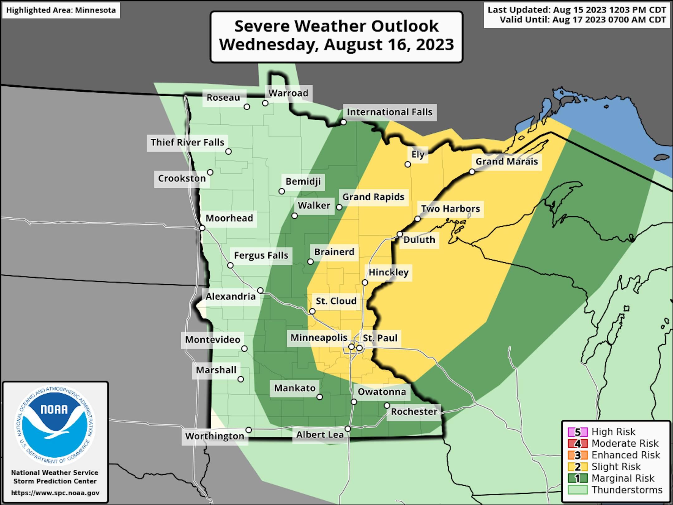
A Slight Risk (threat level 2/5) is in place across eastern Minnesota and western Wisconsin Wednesday afternoon and evening, with large hail and damaging winds the main threats.

(The Minnesota Star Tribune)

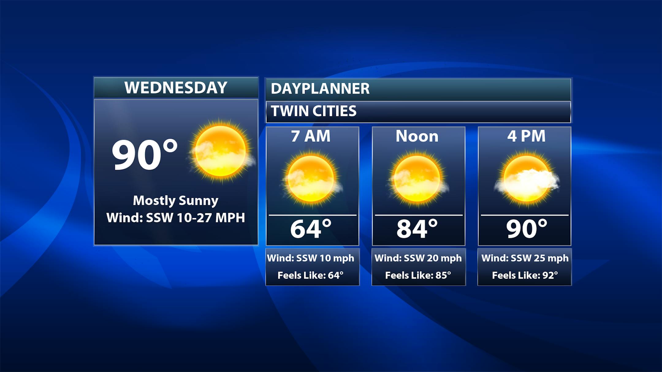
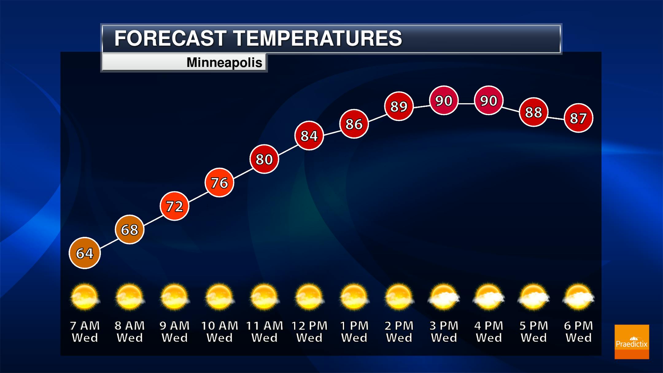
So while we watch that evening severe storm threat here in the metro, most of the day will feature sunshine with some increasing afternoon clouds. Morning temperatures start off in the mid-60s with the 24th 90F-degree day of the year expected in the afternoon.

(The Minnesota Star Tribune)

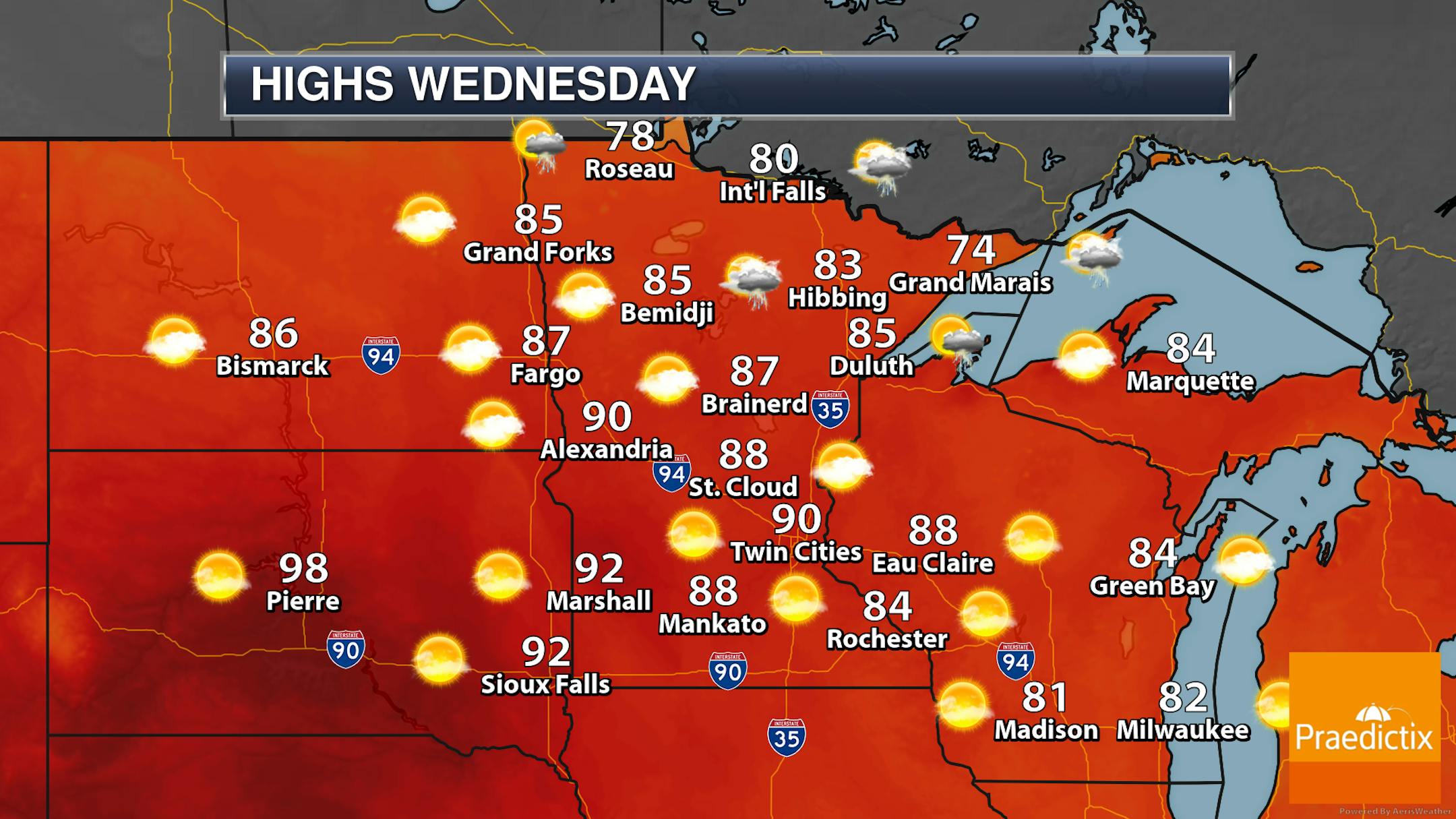
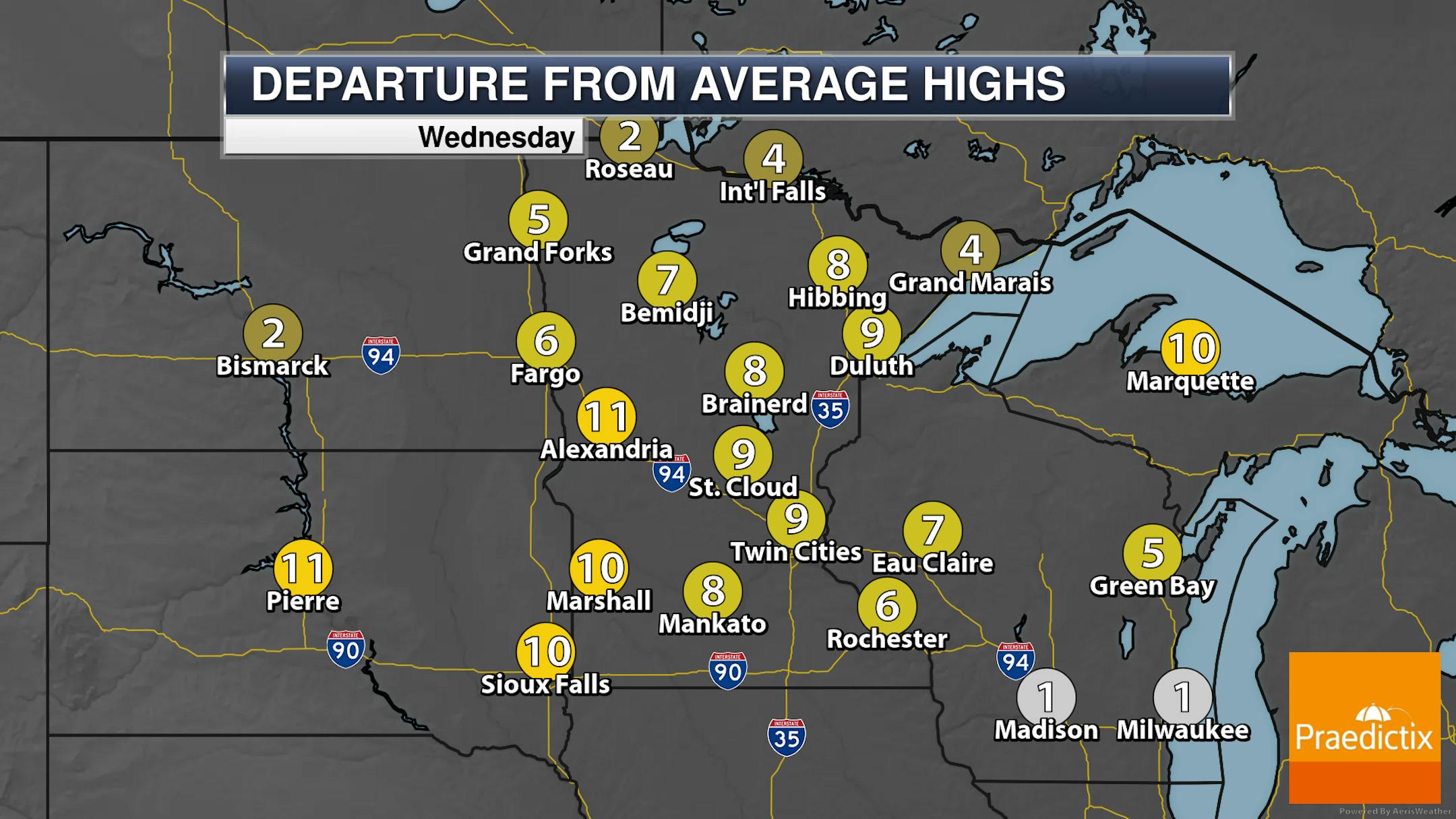
Looking statewide, a few showers or storms will be possible in the afternoon hours in northern Minnesota (as shown in the loop above), with storms popping ahead of the cold front into eastern and southern Minnesota during the dinner hour/evening hours. Otherwise, mainly sunny skies and warm weather is expected. Highs will range from the 70s along the North Shore to the 90s in parts of central and southern Minnesota.

(The Minnesota Star Tribune)

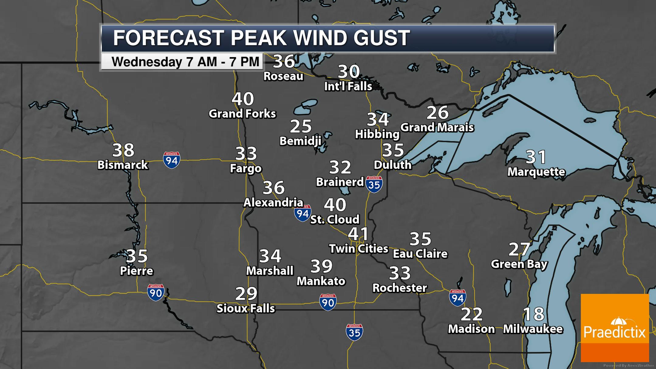
It'll also be a windy day on Wednesday across the state, with a southwesterly breeze in the metro gusting up to around 40 mph.

_______________________________________________

Thursday: Cooler, But Wildfire Smoke Expected To Return

(The Minnesota Star Tribune)

While we will see quiet and sunny weather across the state on Thursday with most locations climbing into the 70s for highs, another batch of Canadian wildfire smoke looks to drift southeastward on the back of strong northwesterly winds.

(The Minnesota Star Tribune)

Near-surface smoke forecast for Thursday morning

Here's a look at the potential smoke near the surface as we head into Thursday morning. While most of it will be up across northern Minnesota at this time, some of it will likely drift south/southeast throughout the day.

(The Minnesota Star Tribune)

The Minnesota Pollution Control Agency is already forecasting air that will be unhealthy for all people across the northern half to two-thirds of Minnesota (in red) Thursday and unhealthy air for sensitive groups across a good portion of southern Minnesota (orange).

(The Minnesota Star Tribune)

Northwest gusts up to 30 mph will be possible Thursday in the metro, with gusts up to 35 mph in the Arrowhead.

_______________________________________________

Blistering Hot Weekend Ahead

(The Minnesota Star Tribune)

Friday: The coolest day of the extended weekend, with highs "only" around average in the low 80s. Mainly sunny skies are expected.

Saturday: Another mainly sunny day, but temperatures take a huge step upward into the mid-90s as we watch a strong ridge over the central United States. Heat index values will be up around 100F. The record high Saturday for MSP is 97F in 1976.

Sunday: Could be the warmest day of the year so far (current warmest: 96F on July 27th) as highs climb into the mid/upper 90s. Heat index values will be in the low 100s. Another sunny day is expected. The record high Sunday for MSP is 97F in 1972.

(The Minnesota Star Tribune)

Heat continues into early next week across the region. The record high Monday for MSP is 98F in 1947.

(The Minnesota Star Tribune)

Here's the listing of the warmest days so far this year at MSP. Through Tuesday, we had hit 90F+ 23 times, with three days seeing a high of at least 95F.

_______________________________________________

5 Day Heat Wave Brewing for Minnesota
By Paul Douglas

A hotter climate translates into stronger, longer heatwaves, accelerating sea level rise, more intense hurricanes and more severe thunderstorm damage. Higher insurance premiums too.

According to Swiss Re 70% of global insured natural catastrophe losses in the first 6 months of 2023 were the result of severe T-storms in the US. Hotter weather increases water vapor; more fuel for extreme storms and more instability capable of spinning up destructive "supercells" with large hail and damaging winds.

Speaking of hot, a sprawling heat dome sets up over the Upper Midwest early next week, with some of the hottest weather of the summer for Minnesota. I see a streak of muggy 90s from Saturday through the middle of next week, with 100-degree heat possible from western Minnesota into the Dakotas. Factor in dew point in the 70s and it may feel like 105-110F early next week. Ouch.

Severe T-storms this evening will be followed by a comfortable Thursday. Enjoy the free A/C while you can. Next week? Blazing saddles.

_______________________________________________

Paul's Extended Twin Cities Forecast

WEDNESDAY: Windy. Severe T-storms? Wake up 64. High 90. Chance of precipitation 50%. Wind S 20-40 mph.

THURSDAY: Sunny, breezy and comfortable. Wake up 63. High 78. Chance of precipitation 0%. Wind NW 15-25 mph.

FRIDAY: Warm sunshine. Wake up 59. High 87. Chance of precipitation 0%. Wind S 10-20 mph.

SATURDAY: Hot, sweaty sunshine. Wake up 70. High 91. Chance of precipitation 0%. Wind S 10-25 mph.

SUNDAY: Sizzling sunshine. Record is 97 (1972). Wake up 72. High 94. Chance of precipitation 0%. Wind SE 8-13 mph.

MONDAY: Sunny, feels like 105+ Record: 98. Wake up 76. High 97. Chance of precipitation 0%. Wind S 10-20 mph.

TUESDAY: Heat peaks. Feels like 105-110F. Wake up 78. High 99. Chance of precipitation 0%. Wind SW 10-20 mph.

_______________________________________________

Minneapolis Weather Almanac And Sun Data
August 16th

(The Minnesota Star Tribune)

*Length Of Day: 14 hours, 2 minutes, and 6 seconds
*Daylight LOST Since Yesterday: 2 minutes and 47 seconds

*When Do We Drop Below 14 Hours Of Sunlight? August 17th (13 hours, 59 minutes, 17 seconds)
*When Are Sunrises After 6:30 AM? August 28th (6:30 AM)
*When Are Sunsets At/Before 8:00 PM? August 27th (7:59 PM)
_______________________________________________

This Day in Weather History
August 16th

1981: Chilly temperatures are felt across Minnesota. Tower reports a low of 33 degrees.

_______________________________________________

National Weather Forecast

(The Minnesota Star Tribune)

We continue to track excessive heat across portions of the southern and western United States on Wednesday. Otherwise, two systems - one in the Upper Midwest and another along parts of the East Coast - will produce storm activity. Monsoonal storms will also be possible in the Southwest.

(The Minnesota Star Tribune)

Heavy rains will impact parts of the eastern United States through the middle of the week, with some areas (particularly across Michigan and Florida) potentially seeing over three inches of rain.

_______________________________________________

Americans Have Breathed More Wildfire Smoke in Eight Months Than in Entire Years

More from Scientific American: "The average American may have already inhaled more wildfire smoke in the first eight months of this year than during any recent full year. What's responsible for the record? Canada's unprecedented blazes, which began in late April, have sent plumes of smoke south to the U.S., impacting communities in the Midwest and along the East Coast that are unaccustomed to wildfires. This event is undermining a decades-long trend toward generally cleaner air in the U.S., driven by decades of reduced anthropogenic pollution. Now experts hope the shock of 2023's smoke will inspire collective and individual actions to reduce future wildfire smoke exposure. This year "fire activity has been near historic lows in most of the western U.S.," says Marshall Burke, an economist at Stanford University. "Yet this will likely be the worst wildfire smoke year on record in the U.S. and [is] entirely due to Canadian fires. So that's really new.""

Why the Maui wildfires were so deadly

More from Axios: "The devastating wildfires in Hawaii this week killed more than 90 people and decimated the historic town of Lahaina on Maui Island. The big picture: The fires are "likely the largest natural disaster in Hawaii's state history," according to Hawaii Gov. Josh Green. Dozens of people have been injured and thousands have been displaced. Officials expect the death toll to continue rising. Maui Mayor Richard Bissen told NBC News's "Today" on Friday that the death toll currently consists of casualties found outside. "We have not yet searched in the interior of the buildings." How it happened: Extreme winds augmented by Hurricane Dora, coupled with existing drought conditions across Hawaii, exacerbated the spread of the wildfires. Researchers believe climate change was likely a contributing factor to the wildfires, exacerbating the drought and making wildfire fuels, like dried out vegetation, more flammable. Nonnative grasses that are more flammable than indigenous plants have also proliferated across Hawaii in recent years, exacerbating the wildfire risk."

Montana youth victory could spur momentum on other climate cases

More from E&E News: "A landmark court decision that Montana is violating its youngest residents' rights to a clean and healthful climate could have legal repercussions well beyond the Treasure State. Judge Kathy Seeley of the 1st Judicial District Court in Montana found Monday that youth in the state have a "fundamental constitutional right to a clean and healthful environment, which includes climate" as she struck down two laws that bar state agencies from considering the climate effects of fossil fuel projects. "This is what climate justice in the courts, and protecting the constitutional rights of our childrens' right to a safe climate, looks like," said Nate Bellinger, senior staff attorney with Our Children's Trust, the Oregon-based law firm that represented the 16 young Montanans."

_______________________________________________

Follow me on:

Thanks for checking in and have a great day!

- D.J. Kayser

(The Minnesota Star Tribune)
about the writer

about the writer

D.J. Kayser

See Moreicon