Warm And Windy Saturday With A Severe Storm Threat

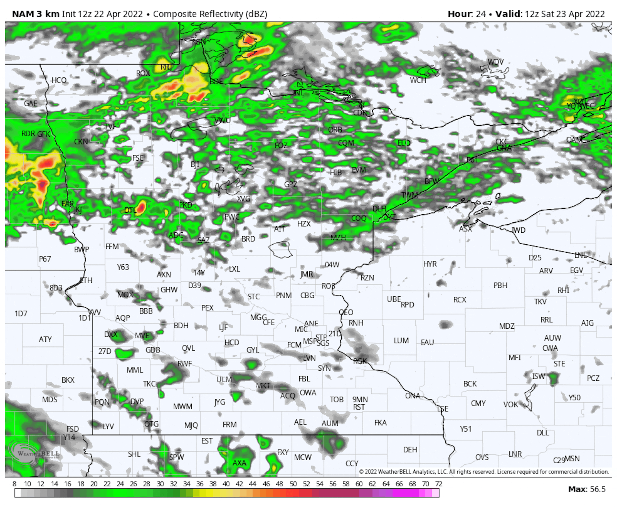
The system impacting the region will continue to do so on Saturday. We'll begin the day with more concentrated showers and some embedded thunder across northern Minnesota, with a batch of showers possible for areas like the Twin Cities at times. As we head into the afternoon, an approaching cold front will help ignite showers and storms that'll move eastward as we head into the evening. Some of those storms could be severe.

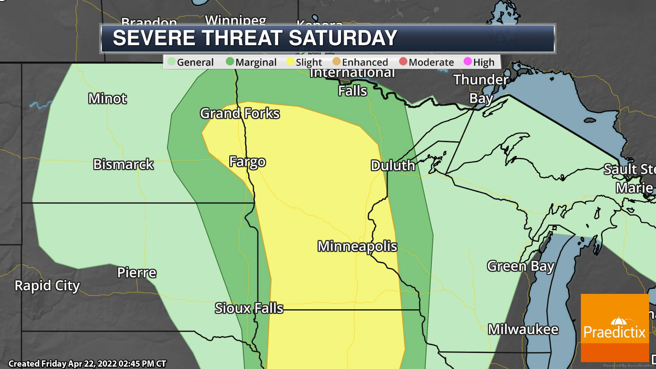
A Slight Risk of severe weather (threat level 1 of 5) covers a good portion of the state for Saturday and Saturday night. In individual storms, all hazards will be possible (tornadoes, hail, and damaging winds). As storms become a bit more linear, damaging winds and maybe an embedded tornado or two will become the threats.

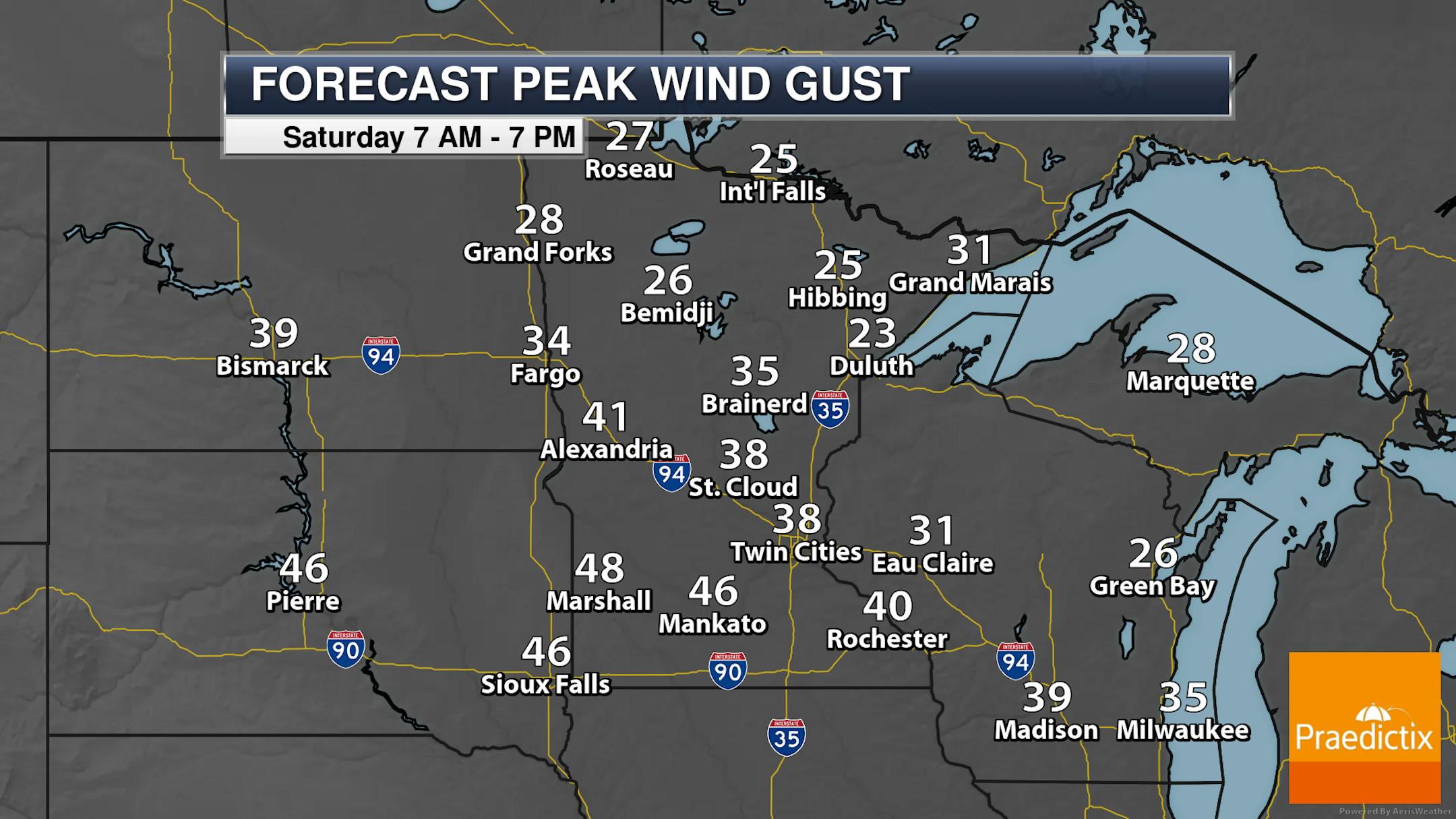
We will also watch strong winds with this system as we head through Saturday. Wind gusts out of the south in the metro could reach 40 mph by late in the day, with gusts up to 50 mph possible in portions of western Minnesota. As you head up toward Grand Marais, those breezy winds will be out of the east - so it'll still be a chilly wind off the lake!

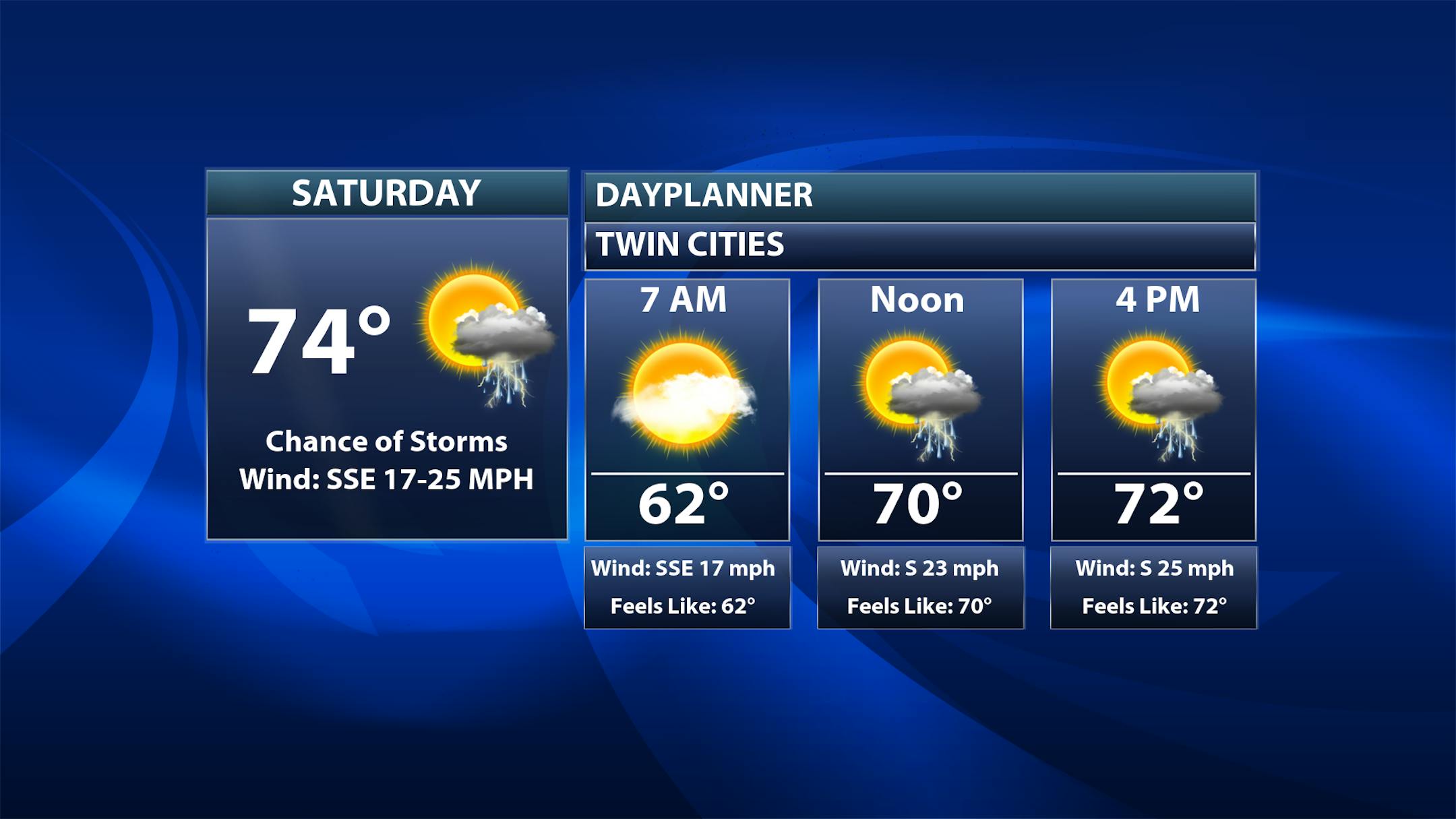
Looking at the forecast for the Twin Cities Saturday, we'll watch that chance of some showers during the morning hours, with some scattered showers and storms ahead and along the cold front in the afternoon and evening hours. Temperatures by 7 AM will already be in the 60s, with highs climbing into the mid-70s - the first 70F high of 2022 and the first since October 19th.

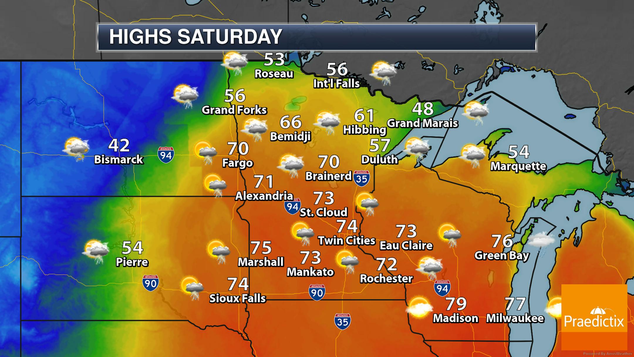
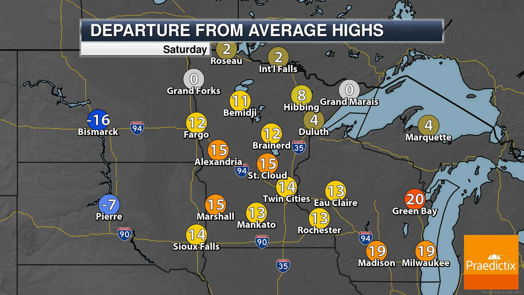
So we will watch those showers and thunderstorms moving across the state as we head throughout the day. Not likely an all-day washout for most, but as the model shows above the most concentrated area of rain through the day could be up in northwestern parts of the state. Warmer air surges in with those strong southerly winds, as highs climb into the 70s across southern and central Minnesota. Highs will even reach the 50s in most of northern Minnesota, minus some areas along the North Shore.

_______________________________________________

Back Below Average After Saturday

Enjoy the one-day warm-up into the 70s Saturday, as it ain't sticking around! Behind that cold front highs will tumble for the second half of the weekend into next week, with the 50s on Sunday and then only 40s on Monday and Tuesday. Monday's high of 42F will be close to the coldest high on record for the day - that was 37F back in 1950.

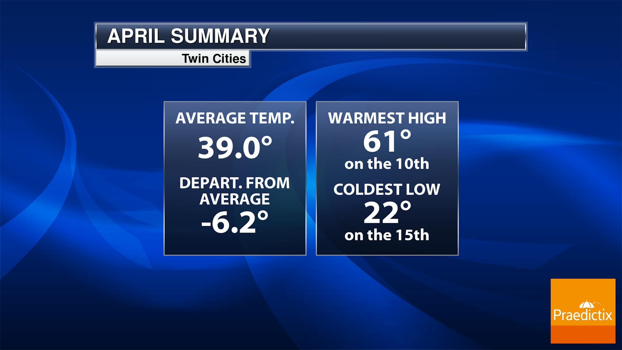
It's been a very cool April so far, with only an average temperature of 39.0F, 6.2F degrees below average. For MSP, it's the 19th coldest start to April on record. As that deficit is not likely to be made up in the last (approximate) week of the month, this will go down as the fourth month in a row with a monthly below-average temperature for MSP.

_______________________________________________

A One-Day Flash of Warmth and Thunder
By Paul Douglas

We've seen some improvement in the state of our environment since the first Earth Day in 1970. Rivers are no longer catching on fire. The ozone hole over the poles is smaller. But big challenges remain.

Minnesota's lakes are fairly clean, but 46% of America's lakes are too polluted for swimming and fishing. 90% of all plastic since 1950 is still in existence. In spite of a chilly spring to date, the Twin Cities are 3.8F warmer than they were in 1970 - statewide Minnesota is 2.7F warmer. Good news: clean wind power provided over 9% of America's electricity last year. Things are moving in the right direction; we just need to go faster.

Soak up today's lukewarm sunshine because a few rough T-storms may pop up by the dinner hour. Sunday looks gray, windy and cooler, but another temperature relapse early in the week should give rise to 60 degrees by late week.

Forget a dimmer switch; this will be a "light-switch spring". Instant-On. NOAA's GFS model predicts 80s in about 2 weeks. Wouldn't that be lovely?

_______________________________________________

Paul's Extended Twin Cities Forecast

SATURDAY: Warm winds. Few T-storms. Wake up 61. High 77. Chance of precipitation 80%. Wind S 20-40 mph.

SUNDAY: Cloudy, windy & cooler. Showers north. Wake up 45. High 50. Chance of precipitation 30%. Wind SW 15-35 mph.

MONDAY: Mostly cloudy and chilly. Wake up 33. High 40. Chance of precipitation 20%. Wind NW 10-20 mph.

TUESDAY: Peeks of sun, a little nicer. Wake up 28. High 42. Chance of precipitation 10%. Wind NW 8-13 mph.

WEDNESDAY: Mostly cloudy, PM sprinkle. Wake up 29. High 46. Chance of precipitation 30%. Wind SE 10-20 mph.

THURSDAY: Milder with a passing shower. Wake up 38. High 58. Chance of precipitation 40%. Wind E 10-15 mph.

FRIDAY: Some sun, stray thundershower. Wake up 44. High 62. Chance of precipitation 40%. Wind E 10-20 mph.

_______________________________________________

Minneapolis Weather Almanac And Sun Data
April 23rd

*Length Of Day: 13 hours, 53 minutes, and 27 seconds
*Daylight GAINED Since Yesterday: 2 minutes and 52 seconds

*When Do We See 14 Hours Of Daylight: April 26th (14 hours, 2 minutes, 30 seconds)
*When Is The Sunrise At/Before 6 AM?: May 3rd (6:00 AM)
*When Is The Sunset At/After 8:30 PM?: May 10th (8:30 PM)

_______________________________________________

This Day in Weather History
April 23rd

1990: A record high of 88 degrees is set at Redwood Falls.

_______________________________________________

National Weather Forecast

A strong April system in the upper Midwest on Saturday will bring severe storms across the central United States with blizzard conditions back in portions of the Northern Plains.

The system moving through the central United States will bring very heavy rain across portions of Iowa (mainly on Friday) with 3"+ possible. Blizzard conditions will be expected from northeastern Wyoming to eastern Montana and the western Dakotas with some areas seeing 12-18" of snow before adding in drifting due to the strong winds with gusts of 45-60 mph possible.

_______________________________________________

Earth Day: U.S. Warming Rankings

More from Climate Central: "Since the first Earth Day 52 years ago, environmental science, policy, and public awareness have transformed in the U.S. and around the world. Earth Day is a time to celebrate this progress and take stock of current challenges—including climate change. The concentration of heat-trapping CO2 in the atmosphere has increased nearly 30% since the first Earth Day in 1970. And when CO2 increases, temperatures follow suit. How has rising CO2 affected temperatures in the U.S.? Climate Central analyzed trends in annual average temperature in 246 locations, all 49 states, and the entire nation since 1970 and found that: The U.S. is 2.6 °F warmer today than it was in 1970. For context, 2.6 °F is very close to the global warming limit of 2.7 °F (1.5 °C) that 196 countries, including the U.S., have agreed to pursue."

Minnesota's climate action plan calls for sweeping changes in energy, farming, transport

More from the Star Tribune: "The public has until April 29 to comment on Minnesota's new plan for combating climate change, a road map for action that would touch nearly every aspect of life in the state. ... The final plan, due out this summer, will contain new recommendations for changes that would slash the heat-trapping greenhouse gases Minnesotans are pumping into a choked atmosphere.It's not the state's first climate change plan over the years but it's the first issued by a group elevated to the level of state subcabinet. Some of the priorities, such as changing building codes, will require Legislative approval, according to the subcabinet."

Insects Are Dying Off Because of Climate Change and Farming

More from Scientific American: "The combined influence of climate change and expanding agriculture are causing insect populations to plummet in some parts of the world, according to a new study that determined the abundance of bugs has dropped by half in the hardest-hit places. That's a big concern for both people and nature. Insects often help form the bedrock of natural ecosystems—they pollinate plants, including agricultural crops, and also provide an important food source for other animals. "Our findings highlight the urgency of actions to preserve natural habitats, slow the expansion of high-intensity agriculture, and cut emissions to mitigate climate change," said lead study author Charlotte Outhwaite, a scientist at University College London, in a statement."

_______________________________________________

Thanks for checking in and have a great day! Don't forget to follow me on Twitter (@dkayserwx) and like me on Facebook (Meteorologist D.J. Kayser).

- D.J. Kayser