Warmer & Drier Start to November So Far

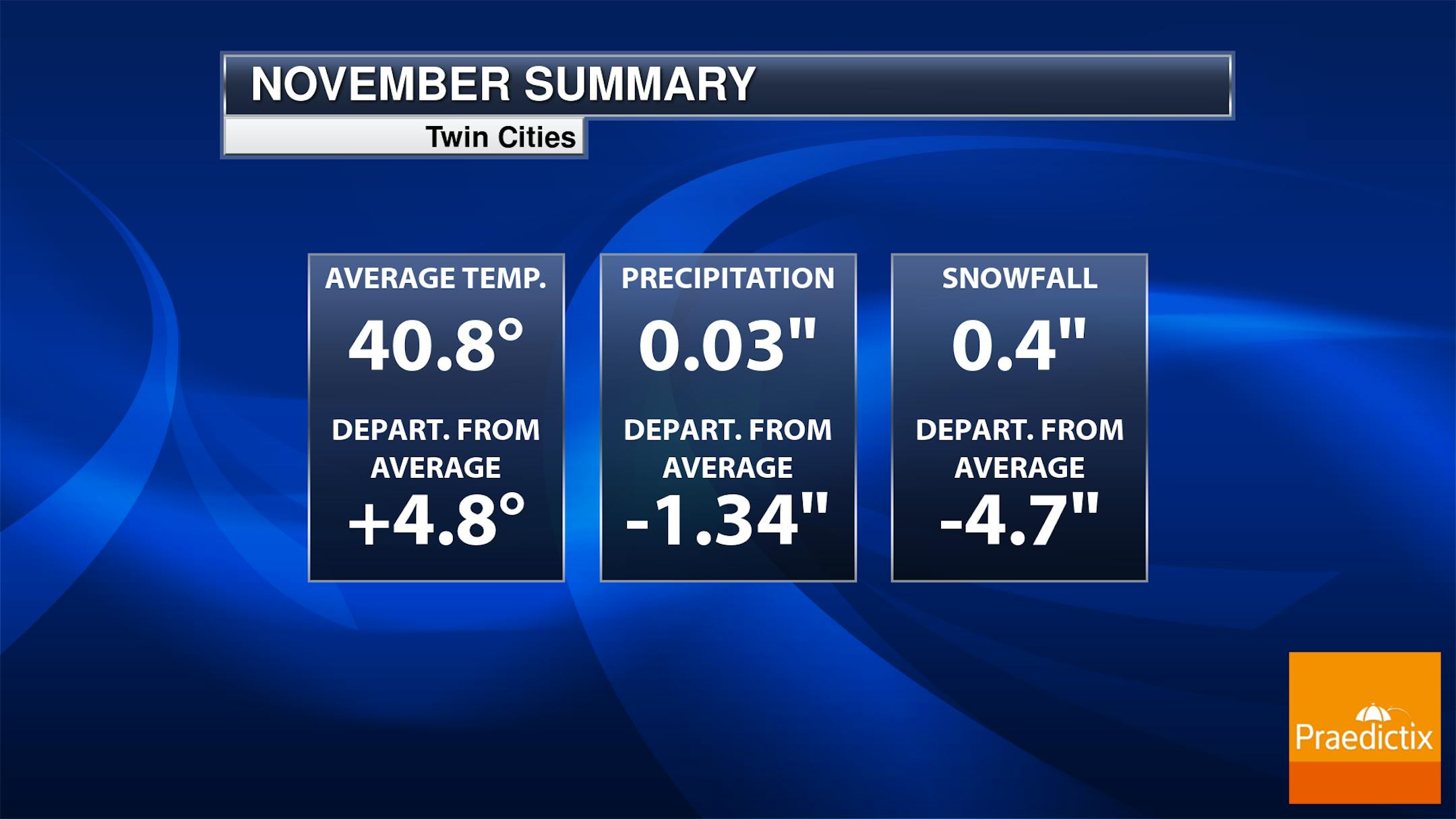
Despite being chillier as of late, this has been a fairly warm month with the average temperature in the Twin Cities running nearly +4.8F above average, which is the 12th warmest start to any November on record. Precipitation is running nearly -1.34" below average, which is tied for the 3rd start to any November on record. We did manage to pick up close to 0.5" of snow at the MSP Airport Saturday night into Sunday, which is tied for the 16th least snowy November on record.

Twin Cities Average Snowfall

The 30-year average from 1993 to 2022 suggests that we typically see around 5.5" of snow during the month of November. The snowiest month tends to be in December with more than a foot falling. The 2nd snowiest month tends to be January with nearly 11" falling in the metro.

Weather Outlook Through Next Weekend

Here's the weather outlook the upcoming weekend, which shows mostly dry and quiet conditions across much of the Midwest through the week. As we approach the weekend, there could be a few areas of light snow and possibly some accumulations from southeastern Minnesota into Wisconsin. Stay tuned...

Drought Update

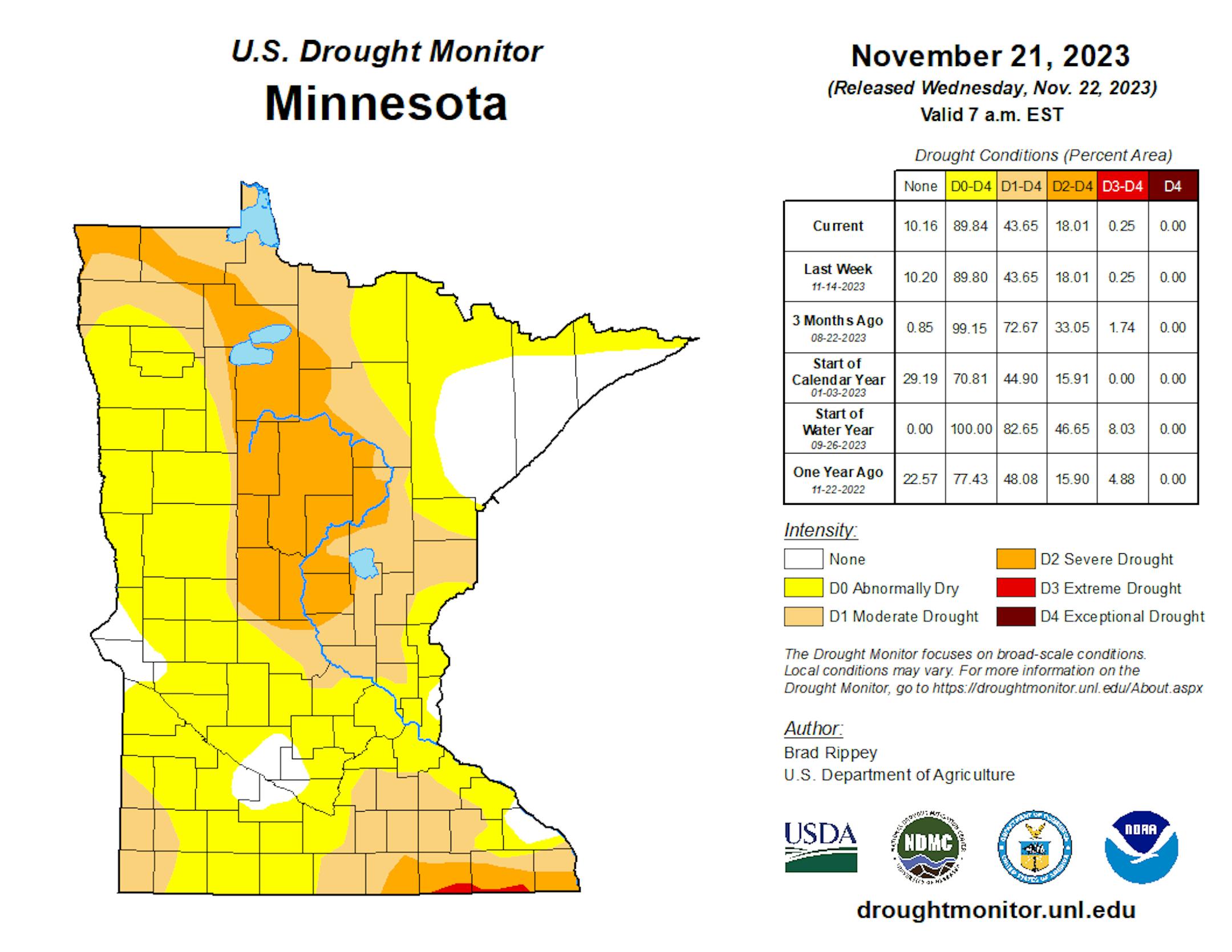
Heavy rains during the month of September have helped the drought situation quite a bit across the state. With that being said, nearly 18% of the state is still in a severe drought, which has improved from 34% nearly 3 months ago.

Twin Cities Weather Outlook For Tuesday

The weather outlook for the Twin Cities on Tuesday, November 28th will still be chillier than average with temperatures only warming into the upper 20s to near 30F, which will be nearly -5F to -10F below average for this time of the year. Skies will be dry and quiet with breezy southwesterly winds developing through the day.

Meteograms For Minneapolis

Temperatures in the Twin Cities will start in the single digits and lower 10s in the morning and will warm into the upper 20s by the afternoon, which will be nearly -5F below average for this time of the year. Skies will be sunnier in the morning with more clouds expected in the afternoon. Southwesterly winds will be breezy later in the afternoon with gusts approaching 20mph to 25mph at times.

Hourly Feels Like Temps For Tuesday

Here are the hourly feels like temps for Minneapolis on Tuesday. This will be some of the coldest weather of the season so far with feels like temps possibly down in the sub-zero range in the morning. Brr!

Weather Outlook For Tuesday

The weather outlook for Tuesday will only warm into 20s across the eastern half of the state, which will be nearly -5F below average. Meanwhile, folks in the western part of the state and across the Dakotas will warm into the 30s and 40s, which will be above average by nearly +5F to +10F for this time of the year.

Extended Temperature Outlook For Minneapolis

The 5 day temperature outlook for Minneapolis looks a little better as we head through the rest of the week and weekend ahead. Temps will get back into the mid/upper 30s and possibly the lower 40s, which will be nearly +5F above average for this time of the year.

Extended Weather Outlook For Minneapolis

The extended weather outlook for Minneapolis looks overall pretty quiet. We'll see mostly dry and quiet conditions through the end of the month and the start of December on Friday. Temps will also be a little warmer with a light snow chance developing later this weekend.

The Extended Outlook Calls For Warmer Temps

According to NOAA's National Blend of Models, it won't be quite as chilly as we approach the end of the month and into early December. Highs will regularly warm into the mid/upper 30s and possibly the lower 40s, which will be above average for this time of the year.

Weather Outlook

Here's the National weather outlook through the weekend ahead. Areas of heavy lake effect snow will continue across the Great Lakes Region through midweek. However, much of the rest of the nation will be quiet until later this week and weekend ahead. Some of the heaviest precipitation will be found across the Southern and Northwestern US.

8 to 14 Day Temperature Outlook

According to NOAA's Climate Prediction Center, the 8 to 14 day temperature outlook shows warmer than average temperatures returning to much of the nation, including the Midwest. The early part of December looks to start on a milder note than what we're seeing now.

8 to 14 Day Precipitation Outlook

The 8 to 14 Day Precipitation Outlook shows more active weather in place the Northwestern US. Meanwhile, it looks a little drier across the Southwest and the Central US.

Very Little Weather Drama In Sight
By Paul Douglas

"Paul, our winters aren't what they used to be. When I was little the snow would come up to my chest!" Yes, and you were 2 feet tall at the time.

Was last winter's 90.3" at MSP (3rd snowiest on record) an aberration or a trend? A warming atmosphere can hold more water vapor, even in winter. As long as it's still cold enough for snow, winters in the coming years may be snowier.

Dr. Mark Seeley reports 4 times more midwinter rain and ice in the metro since 2000, and based on a strong El Nino we may see more ice and mixed precipitation events this winter.

Yesterday was probably the coldest day for the next 2 weeks. Low 40s Wednesday will feel good, and ECMWF is hinting at a string of 40s late next week. December will start on a very temperate (tame) note, weatherwise.

No headline-worthy snowstorms brewing, but a weak disturbance may spread a little slushy snow into town Saturday night and Sunday. Another nuisance "storm" but old timers might say "it's just flurries!" Winter is starting out quiet indeed.

Extended Forecast

TUESDAY: Sunny, and nicer. Winds: S 10-20. High 32.

TUESDAY NIGHT: Mostly clear and quiet. Winds: SSW 10-15. Low: 25.

WEDNESDAY: Blue sky, more like late October. Winds: W 8-13. High 43.

THURSDAY: Some sun, a cooler breeze kicks in. Winds: NW 15-25. Wake-up: 27. High 35.

FRIDAY: Sunny with less wind. Winds: W 7-12. Wake-up: 24. High 34.

SATURDAY: Clouds increase. Light snow at night. Winds: SE 10-20. Wake-up: 27. High 35.

SUNDAY: A little light snow. Winds: NW 7-12. Wake-up: 28. High 35.

MONDAY: Plenty of sun, quiet. Winds: W 10-15. Wake-up: 25. High: 38.

This Day in Weather History

November 28th

1983: Widespread snowfall occurs across much of central Minnesota with snowfall totals at or above 1 foot in many areas. A record 15 inches fell in Gaylord and 14 inches fell in Farmington.

1960: A major storm produces near hurricane force winds on Lake Superior, with 20 to 40 foot waves on the lake. Erosion and damage occurred on the North Shore.

Average High/Low for Minneapolis

November 28th

Average High: 36F (Record: 58F set in 1941)

Average Low: 22F (Record: -21F set in 1887)

Record Rainfall: 1.08" set in 1987

Record Snowfall: 7.5" set in 1905

Sunrise/Sunset Times for Minneapolis

November 28th

Sunrise: 7:26am

Sunset: 4:34pm

Hours of Daylight: ~9 hours & 07 minutes

Daylight LOST since yesterday: 1 Minutes & 44 Seconds

Daylight LOST since Summer Solstice (June 21st): ~ 6 Hour & 40 Minutes

Moon Phase for November 28th at Midnight

1.9 Days After Full "Beaver" Moon

"Nov. 27 at 3:16 a.m. CST - Some accounts suggest the name Beaver Moon came from the fact that this moon signaled it was time to set beaver traps before the swamps freeze to ensure a supply of warm winter furs! Another interpretation suggests that the name Beaver Full Moon comes from the fact that the beavers are now active in their preparation for winter. Also called the Frosty Moon."

National High Temps on Tuesday

The weather outlook on Tuesday looks plenty chilly across the eastern half of the nation with temps running nearly -10F to -20F below average.

National Weather Outlook For Tuesday

The National Weather Outlook on Tuesday shows areas of heavy lake effect snow continuing across the Great Lakes. Meanwhile, much of the rest of the nation looks quiet for now.

National Weather Outlook

The National Weather outlook through Wednesday shows lingering lake effect snow showers with more than a foot of snow falling in spots There could be some decent precipitation across parts of California as we approach midweek. Meanwhile, much of the rest of the nation remains quiet.

Extended Precipitation Outlook

The extended precipitation outlook shows heavier precipitation across the Eastern US and especially across the Gulf Coast States. There will be another surge of heavier precipitation in the Pacific Northwest with some high elevation snow.

Extended Snowfall Outlook

According to the ECMWF weather model, areas of heavy snow in the Rockies and also across the Great Lakes and Northeast.

Climate Stories

"Climate change is happening. Why do so many of us still act like it's not?"

"Climate-fuelled disaster is now front-page news, as record-breaking floods, fires, droughts, and storms keep arriving. The damage done by climate change is systemic and pervasive, resonating through our communities, economies, and environments. It manifests in many ways, from empty spaces in supermarket shelves to houses left unlivable after floods, anxious communities, collapsing ecosystems, and emergency services stretched to capacity. Climate researchers initially assumed that if you gave people the right information, we would act on it. Burning fossil fuels comes with severe consequences—so let's phase out fossil fuels. But they found out very quickly this was not the case. For many people, it triggered cognitive dissonance, where they knew climate change was happening but acted like it wasn't. After all, many people still smoke, even though they know it is bad for their health. And many of us still fly to Italy—even though we know how many extra tonnes of carbon dioxide we put into the atmosphere."

See more from Fast Company HERE:

"Five Times as Many Human Deaths From Extreme Heat Expected by 2050"

"Nearly five times more people will likely die due to extreme heat in the coming decades, an international team of experts said Wednesday, warning that without action on climate change the "health of humanity is at grave risk". Lethal heat was just one of the many ways the world's still-increasing use of fossil fuels threatens human health, according to The Lancet Countdown, a major annual assessment carried out by leading researchers and institutions. More common droughts will put millions at risk of starving, mosquitoes spreading farther than ever before will take infectious diseases with them, and health systems will struggle to cope with the burden, the researchers warned. The dire assessment comes during what is expected to be the hottest year in human history – just last week, Europe's climate monitor declared that last month was the warmest October on record. It also comes ahead of the COP28 climate talks in Dubai later this month, which will for the first time host a "health day" on December 3 as experts try to shine a light on global warming's impact on health."

See more from Science Alert HERE:

"Microplastics Could Be Affecting the Weather, Too"

"New research is the latest to show that microplastics have polluted just about everywhere on Earth. Scientists discovered plastic particles in cloud samples collected from atop a mountain in Eastern China. The team also found evidence from lab experiments that these microplastics could potentially affect cloud formation and the weather, though more data will be needed to understand exactly how. The study was led by scientists from Shandong University. Among other things, they were inspired by a recent study published in September—one where scientists found microplastics in samples of mist collected at the peaks of Mount Fuji and Mount Oyama, both in Japan. The team decided to look for and analyze microplastics in the clouds surrounding the top of Mount Tai, a well-visited and culturally important mountain that's close to densely populated areas of Eastern China. They studied 28 liquid samples collected during summer 2021."

See more from Gizmodo HERE:

Thanks for checking in and don't forget to follow me on Twitter @TNelsonWX