"Maps of the 2023 'Ring of Fire' Solar Eclipse"
"On Saturday, Oct. 14, an annular or "ring of fire" solar eclipse will sweep across much of the Western Hemisphere. North and Central America The darkest part of the moon's shadow will slide from Oregon to Texas on Saturday morning, then cross the Gulf of Mexico into Central America. Viewers inside this dark band — the path of annularity — will see a ring of light around the moon for up to 5 minutes. Viewers outside the path of annularity will see the crescent sun of a partial solar eclipse. The map below shows the path of the eclipse, and the approximate local time when the ring of fire will be visible."

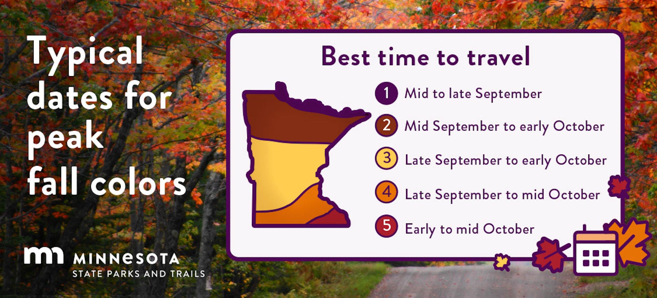
"Where to watch the solar eclipse in Minnesota"
Start looking for eclipse glasses as Minnesotans may be able to see a solar eclipse on Saturday, weather permitting. What's happening: An annular solar eclipse, also known as a "ring of fire" eclipse, will be visible across the U.S. on Oct. 14, and Minnesota is partially in its path. Most of the state will see 40%-50% maximum obscuration. It's the first solar eclipse visible in Minnesota since 2017 — though that one was obstructed by clouds and rain — and it will be the last annular eclipse visible from the U.S. until 2039. What to know: The eclipse is expected to peak locally around 11:45am with 45% coverage of the sun, according to NASA. Reality check: The forecast is showing mostly cloudy on Saturday with a 60% chance of rain, including potential showers during the eclipse's peak, per NWS. Local museums and observatories are still planning parties, including some that are rain or shine.
Here's where you can watch: The Bell Museum: The St. Paul natural history museum will have planetarium shows about eclipses, a pinhole projection station for guests to make their own viewing devices and a livestream of the eclipse from New Mexico, which is expected to see the ring of fire, from 10am-2pm. Eagle Lake Observatory: The Minnesota Astronomical Society will host a viewing event using its telescopes at its home base in Carver County from 10am-2pm. It's free to attend, but the event will be cancelled if cloudy.
Wet & Windy Friday Ahead
Here's the simulated radar from 1AM Friday to 1PM Saturday, which shows very wet weather in place on Friday with heavy rain at times. Showers will linger through the early half of Saturday with total rainfall amounts approaching 1" to 2" (possibly up to 3") across the southern half of the state. Wind gusts could approach 30mph to 40mph during that time frame.

Extended Precipitation Outlook
Here's the extended precipitation outlook through the weekend, which shows widespread 1" to 2" tallies across the southern half of the state. Some locations could potentially see up to 3", mainly across the southwestern part of the state. This could be another drought denting rain for many, but still not enough to get out of the drought.

90 Day Precipitation Anomaly
Thanks to some recent heavy rains parts of the state are now in a surplus over the last 90 days. Some of the biggest surpluses (which aren't many) are showing up in blue in pockets along and north of the Twin Cities and also just east of the metro in western Wisconsin.