
Tuesday Marks The Winter Solstice
"Here's what happens on the longest night of the year—in the solar system and across different cultures here on Earth. IN 2021, THE winter solstice for the Northern Hemisphere happens on December 21. While not as dramatic as 2020's conjunction of Jupiter and Saturn, the longest night of the year is a significant turning point. Astronomical winter begins, and the days gradually get longer again. Curious why this happens? WIRED spoke with Tansu Daylan, a Transiting Exoplanet Survey Satellite (TESS) postdoctoral associate at MIT, to better understand the winter solstice and our planet's relationship with the sun. To picture what is happening in space during a winter solstice, start by thinking of a giant glass ball surrounding the Earth, and let's ignore the planet's rotation (which complicates everything). Daylan says, "If you look at the three-dimensional sphere that's around us, known as the celestial sphere, the sun as well as all other solar system objects move through a plane in this celestial sphere, known as the ecliptic plane."

Snowy Tuesday Morning For Some
A quick moving storm system will push through the region early Tuesday with light snow accumulations across the northern half of the state. The Twin Cities will be on the southern edge of the system, so amounts should be fairly light (up to 1"), but it could make roadways slippery for the AM commute. The heaviest tallies will be found across parts of central and northern Minnesota, where some 2" to 5" tallies can't be ruled out.

Snowfall Potential
Here's the snowfall potential from our AM Tuesday system. Note that the heaviest tallies will be found across the northern half of the state, where some 2" to 5" tallies can't be ruled out. Across the Twin Cities, amounts will range from a light coating across the south metro to an inch or so across the north metro.


Weather Outlook From AM Tuesday to PM Sunday
Here's the weather outlook from AM Tuesday to PM Sunday, which shows our light snow potential early Tuesday and a light wintry mix possible again AM Thursday. Another system could bring light rain/snow to the area on Friday, which could change to snow on Saturday. The weather ahead looks a little more active, but there won't be any major snow events through the Christmas weekend.

GFS Extended Snowfall Potential
Here's the extended snowfall potential through the Christmas weekend, which shows some of the heaviest tallies across the international border.

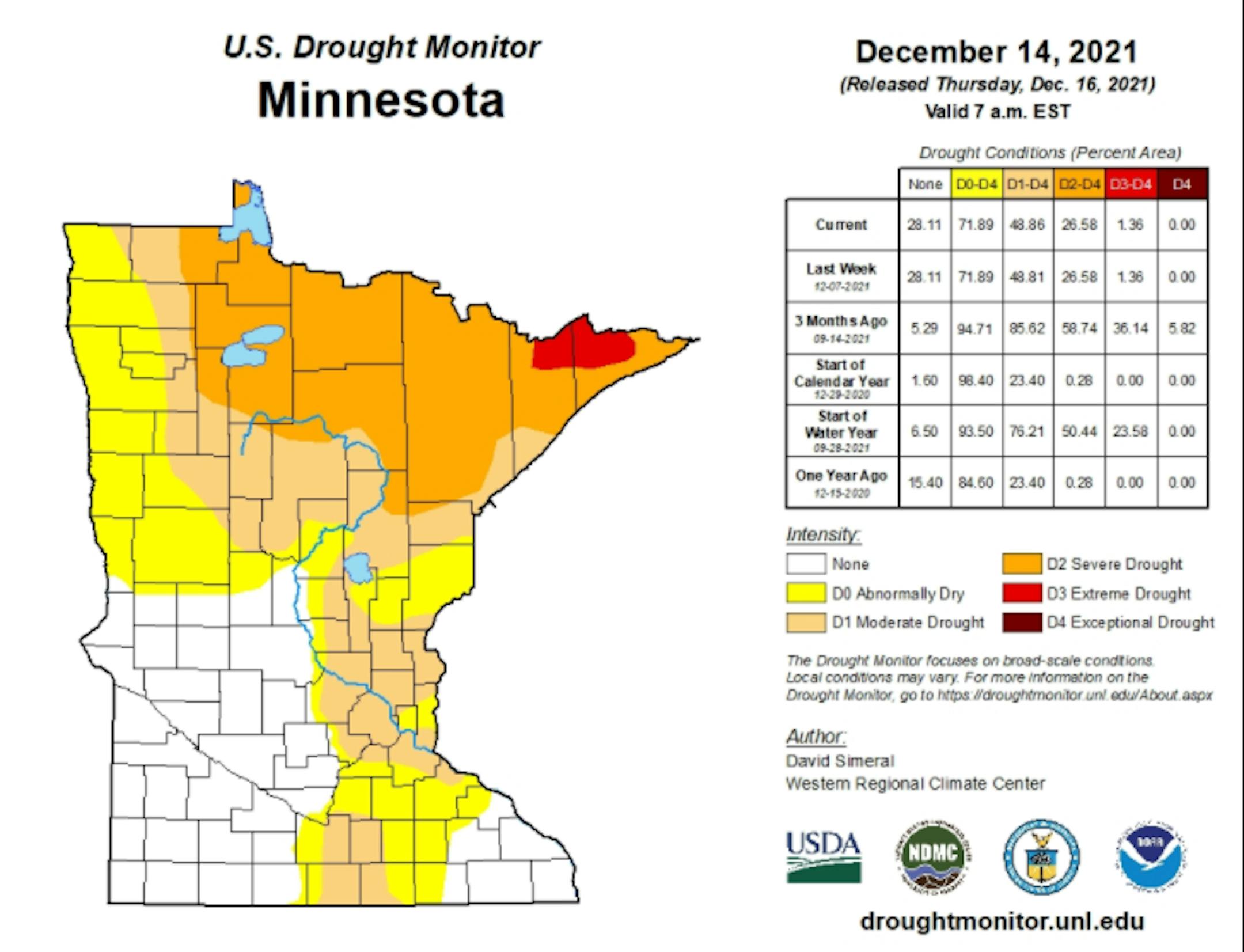
Drought Update For Minnesota
According to the US Drought Monitor, nearly 1% of the state is still considered to be in an extreme drought (in red across northern Minnesota), which is down from nearly 36% from 3 months ago. There has been a slight improvement in Severe Drought, which is at 27%, down from 59% 3 months ago. Nearly 49% of the state is still under a Moderate Drought, which includes much of the Twin Cities Metro.
Precipitation Departure From Average Since January 1st
Here's a look at the precipitation departure from average since January 1st and note that most locations are still several inches below average, including the Twin Cities. The MSP Airport is still -5.73" below average since January 1st, which is the 57th driest January 1st - December 19th on record.


