
"Winter Solstice 2020: When Is It, And What Is It?"
"When is the Winter Solstice? The winter solstice for the Northern Hemisphere occurs on Monday, December 21, 2020 at 4:02 a.m. CST. What Is the Winter Solstice? It's the astronomical moment when the Sun reaches the Tropic of Capricorn, we have our shortest day and longest night of the year in the Northern Hemisphere in terms of daylight. Regardless of what the weather is doing outside your window, the solstice marks the official start of winter. What is Does "Solstice" Mean? The term "solstice" comes from the Latin words sol (sun) and sistere (to stand still) because, during the solstice, the angle between the Sun's rays and the plane of the Earth's equator (called declination) appears to stand still."

"Are you dreaming of a white Christmas?"
"Minnesota. Maine. Upstate New York. The Allegheny Mountains of Pennsylvania and West Virginia. Practically anywhere in Idaho. And of course, the Rockies or the Sierra Nevada Mountains. These are the parts of the Lower 48* where weather history suggests you want to be if you're looking for the best chance of a white Christmas. The map at right shows the historic probability of there being at least 1 inch of snow on the ground in the Lower 48 states on December 25 based on the latest (1981-2010) U.S. Climate Normals from NOAA's National Centers for Environmental Information (NCEI). The background map shows interpolated values for all locations. (Interpolating means estimating unknown values using known values and physical relationships, such as the way temperature is known to change with altitude.) You can also click and zoom in to specific stations used for the interpolation. Darkest gray shows places where the probability is less than 10%. (Sorry West Coast, Gulf Coast, Deep South!) White shows probabilities greater than 90 percent."

Snowfall Potential Through 7PM Tuesday
A quick moving clipper system will scoot through the region PM Sunday into early Monday with minor snow accumulations generally along and north of the I-94 corridor. Some of the heaviest will be found in the northern half of the state with 1" to 3" of snow possible. Unfortunately, it doesn't look like this will give the Twin Cities 1" of snow, which is needed to be an official white Christmas. However, we have another shot of snow mid-week, which could bring accumulating snow to parts of the region, including the Twin Cities!

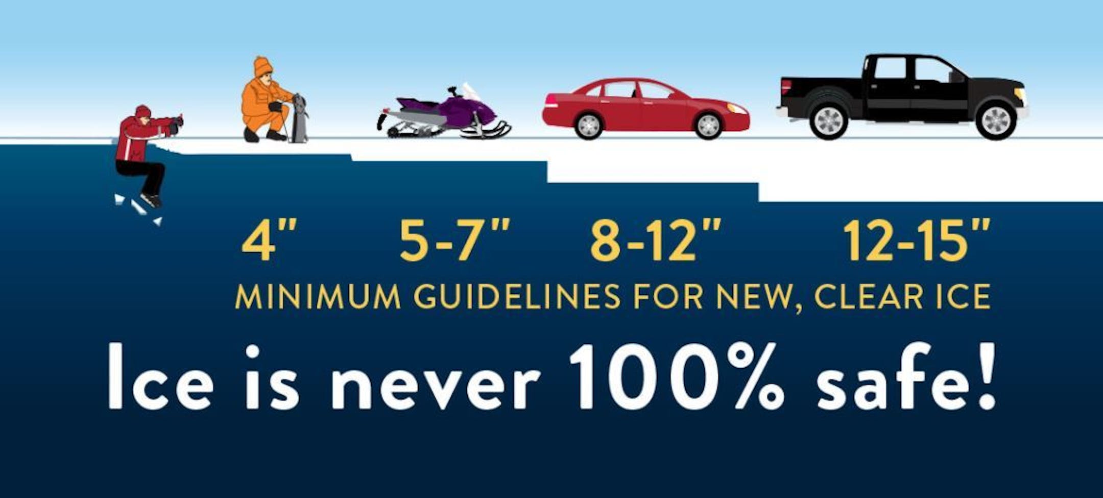
Ice Safety Guidelines
We've had several nights sub-freezing across the state and with that, ice is forming on area lakes and ponds. Keep in mind that many lakes around that state are still not safe to venture out on as of yet! Note that ice is never 100% safe, but you need at least 4" of ice to safely walk on. Stay safe out there!!
Minneapolis December Summary So Far
Here's a look at the December number so far and through the first half of the month, MSP is nearly +8 degrees above average, which is tied for the 8th warmest December on record. It has also been a dry with only 0.06" of precipitation falling. We've also only had 0.6" of snow, which is nearly -7.0" below average through the first part of the month, which is tied for the 3rd least snowy December on record.

Least Snowy Decembers
With only 0.6" of snowfall falling at the MSP Airport, we're on track to have the 3rd least snowy December at MSP on record. Interestingly, there was only a Trace of snow in 1943 and 1913. We still have about 2 weeks left of the month and a lot can happen between now and then. Stay tuned!


