Northern Minnesota Wildfire Update

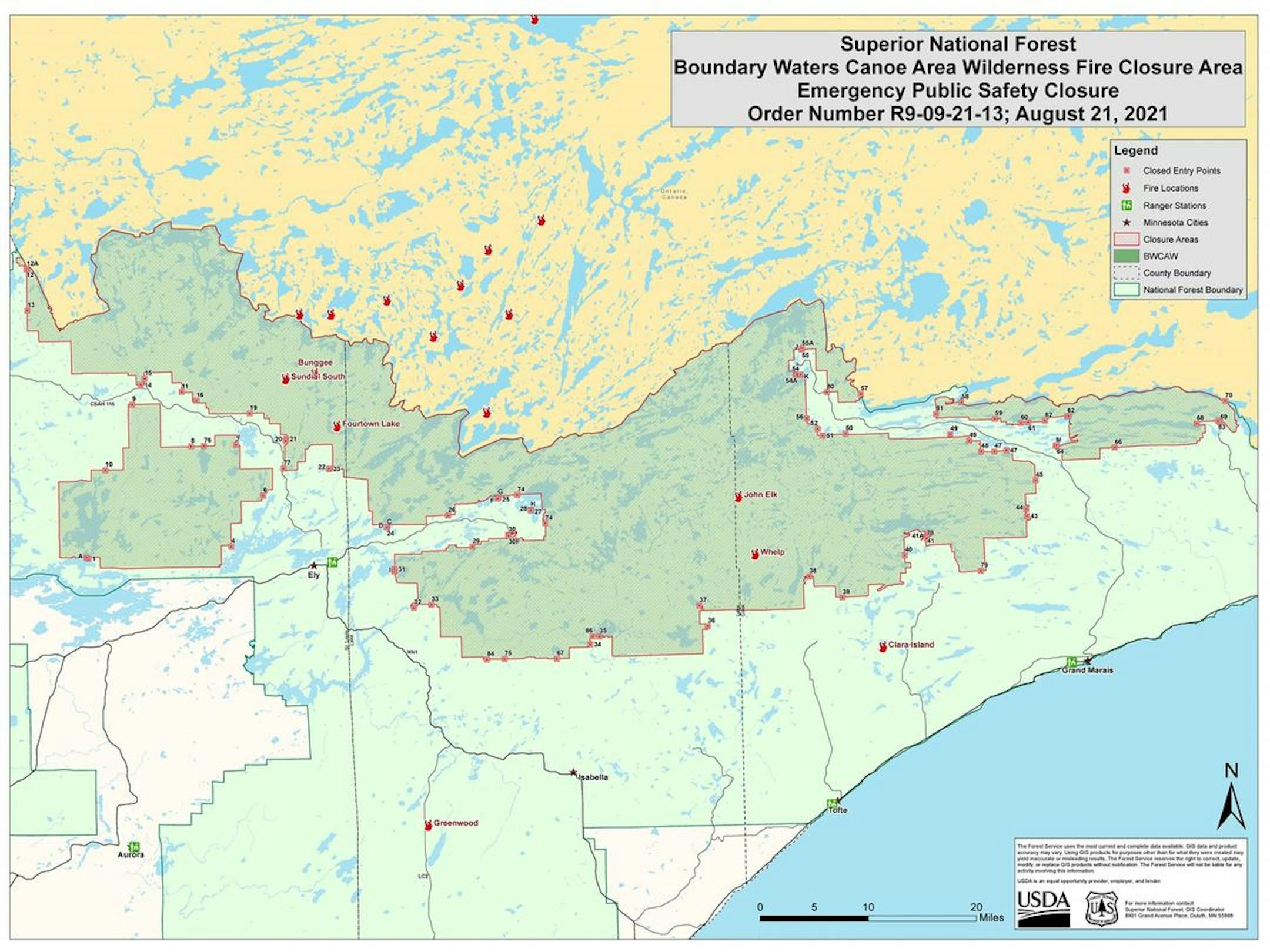
First, we'll start with the news that the Superior National Forest shut down the Boundary Waters Canoe Area on Saturday for seven days, "due to active and increasing fire activity, extreme drought, limited resources."

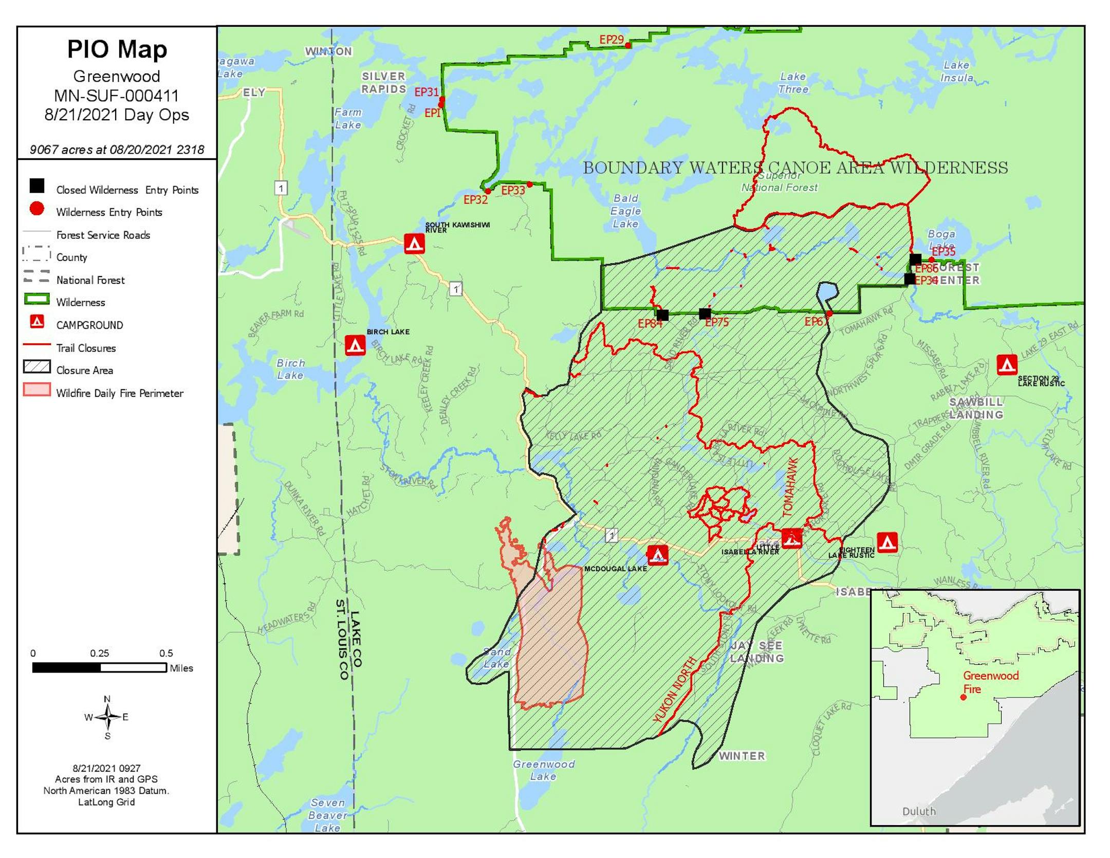
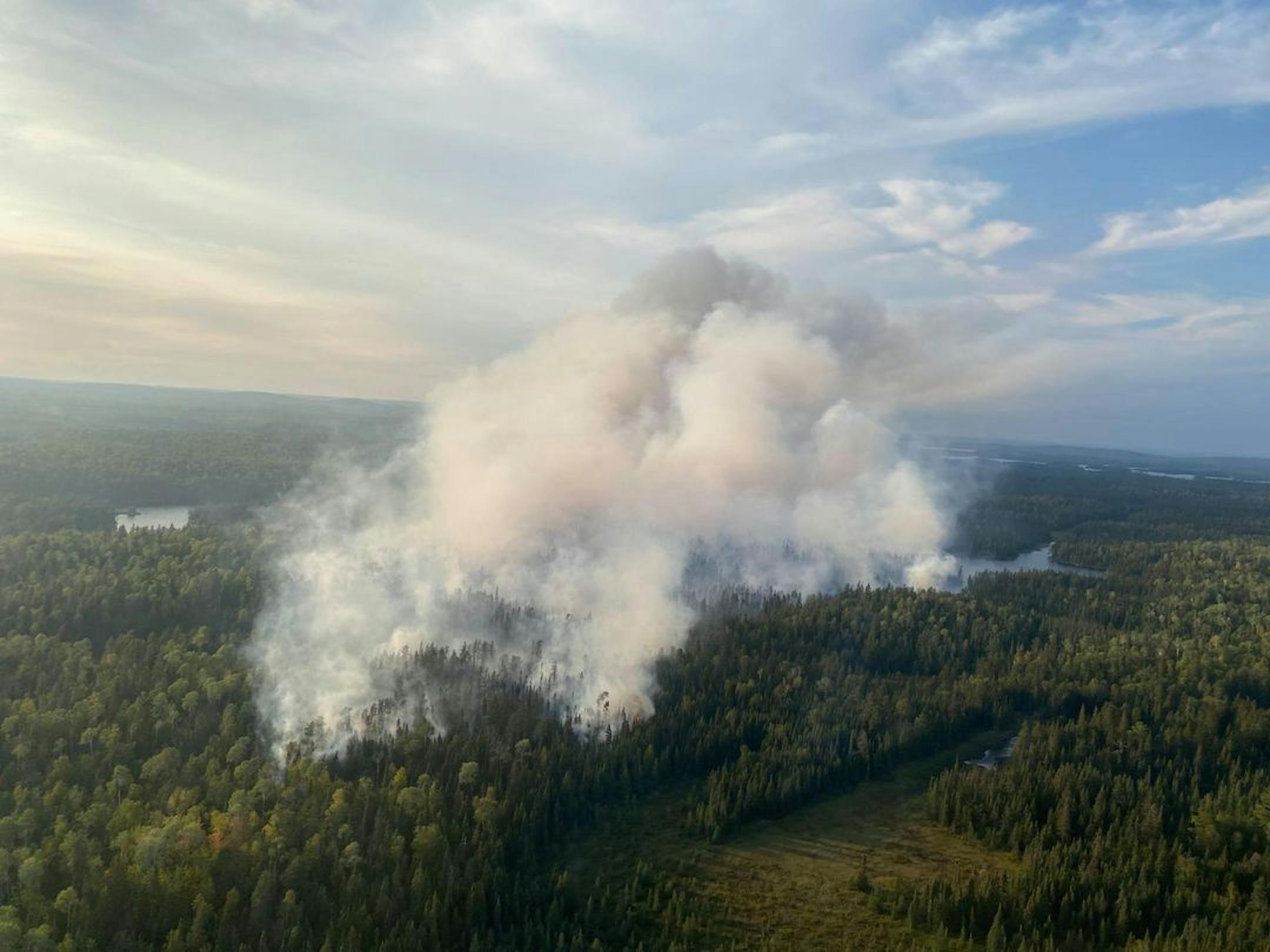
The latest on the Greenwood Fire is that it had significantly increased in size the past several days with strong winds in place - now up to an estimated 9,067 acres after crossing Highway 2. Inciweb has the latest information on this fire.

Picture via the Superior National Forest Facebook page.

Another fire to keep an eye on is the John Elk Fire. It has grown rapidly from three acres to 1,500 acres. Inciweb also has the latest on that one.

_______________________________________________

Storm Reports And Rain From Friday/Friday Night

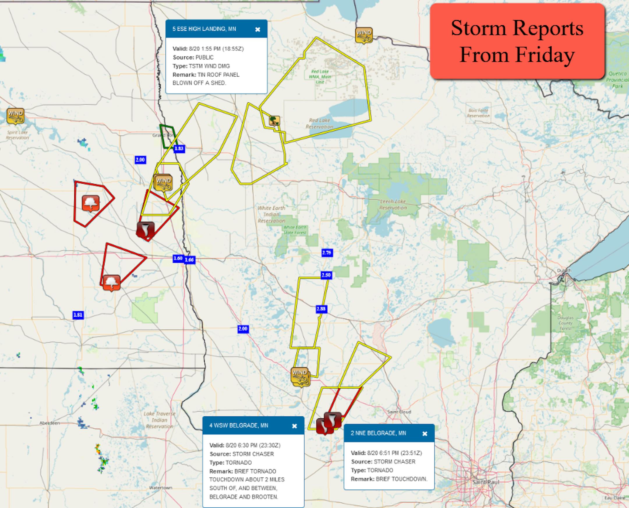
We saw several reports of severe weather across central and northwestern Minnesota on Friday. Out in western Stearns County, there were a few brief tornadoes that occurred in the Belgrade and Brooten areas. We also saw wind gusts of 60 mph and 62 mph around Alexandria and 52 mph in Baudette.

Some areas of the state saw heavy rain, with over 2-3" falling from storms that kept moving over the same areas. Most areas of the metro saw much less rain than that, with only 0.10" falling at MSP airport. The Greenwood Fire area only saw up to an estimated 0.10" according to NWS Duluth.

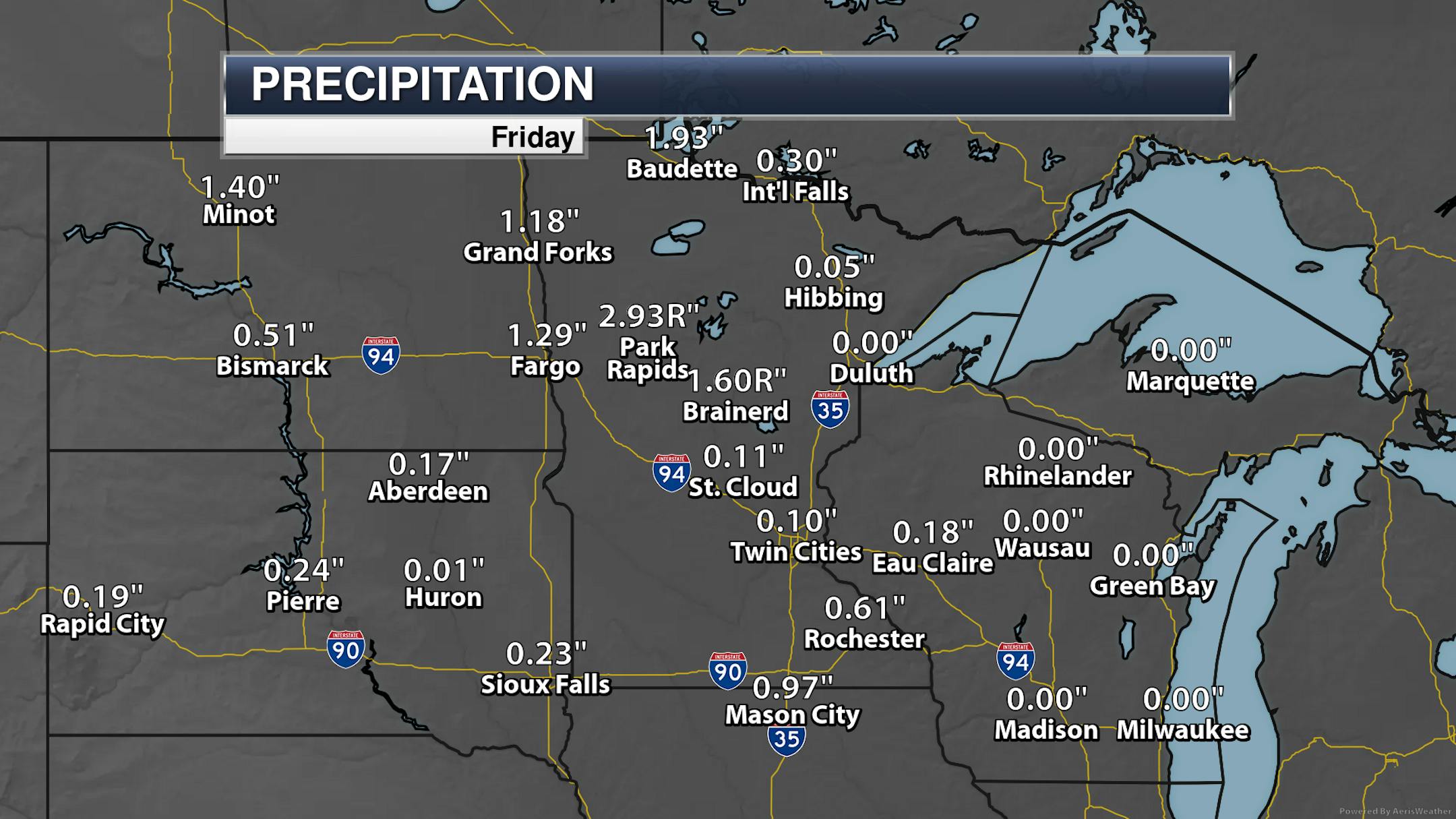
We did see record rain fall in Park Rapids and Brained Friday as they got in on some of the heavier rain across the state. The previous record for Park Rapids was 1.96" (1899), and the previous record for Brainerd was 1.10" (1899).

_______________________________________________

Sunday Weather Outlook

Another sunny, nice, but somewhat breezy day is on tap as we head into Sunday. Morning lows start off in the upper 50s with highs climbing to the upper 70s. A few more clouds will be possible later in the day, with showers and storms possible as we head into Sunday night and early Monday morning.

The storm potential you see across portions of northwestern Minnesota will be during the late afternoon hours as we watch another round of showers and storms move across the state during the evening/overnight hours. Highs will generally be around average.

Here's a simulation of how the shower and storm activity could occur as we head into late Sunday and Sunday Night (loop goes from 1 PM Sunday to 7 AM Monday). This model shows rain reaching the metro in the 10-11 PM timeframe.

A few of the storms late Sunday and Sunday Night could be on the strong side, particularly southwest of the metro. We could see hail, wind, and some isolated tornadoes.

_______________________________________________

Highs Through Mid-Week

After around average highs on Sunday, we'll climb to highs 5-10F degrees above average Monday and Tuesday in the mid to upper 80s. A cold front will push through late Tuesday or Tuesday Night with potentially strong to severe storms. That'll help knock temperatures back to around average for Wednesday and for the start of the State Fair Thursday. More precipitation chances return Thursday and Friday as we are in a bit more of an active pattern. We can hope that this rain will help the drought (and wildfire) situation across the region.

_______________________________________________

An Update On The 90F Count

After three consecutive days with a high of 90F between Wednesday and Friday in the Twin Cities, we now sit at 25 days with a high of at least 90F in 2021. This is tied for the 10th most on record though August 20th, tied with 2007, 1935, and 1894. If we didn't see any more 90F degree days this year we would be tied for the 21st most on record. The most was 44 back in 1988 (which is also the most on record through August 20th).

_______________________________________________

The Fall Color Finder Has Updated...

It might be a little early, but the MN DNR updated their fall color map across the state on Thursday... but no state parks are reporting anything at the moment. Just a sign that fall is on its way! You can follow the MN DNR Fall Color Finder throughout the fall color season by clicking here.

_______________________________________________

The Drought of 2021 Is On A Dimmer Switch
By Paul Douglas

Droughts don't have an on-off switch. History shows it's more of a dimmer switch: it takes months, sometimes years to dig out from big rainfall deficits.

Much of Minnesota is down 8-10" since April 1. Thursday, on WCCO Radio, Dr Mark Seeley explained when we often see drought-busting rains. "Autumn precipitation is the big player in soil moisture recharge" he explained. 6 out of 7 long-term models keep Minnesota drier than average into November. Seeley says facts on the ground match up better with the 1988 drought, not 2012. He expects this drought will linger into 2022.

It felt like late September yesterday, but winds ease today under blue sky; daytime highs rebounding into the 80s Monday and Tuesday before cooling later in the week.

The pattern looks more promising for T-storms the latter half of this week as a cool, Canadian boundary creates a focal point for convection. Not the steady soaking we need, but one week at a time.

"Henri" slams into Long Island today with flooding rain and damaging surf.

_______________________________________________

Paul's Extended Twin Cities Forecast

SUNDAY: Sunny, nighttime T-storm. Wake up 57. High 78. Chance of precipitation 30%. Wind SE 10-15 mph.

MONDAY: Partly sunny and warmer. Wake up 63. High 86. Chance of precipitation 20%. Wind NW 7-12 mph.

TUESDAY: Sticky, T-storms swarm late? Wake up 68. High 84. Chance of precipitation 50%. Wind SE 10-20 mph.

WEDNESDAY: Sunny intervals, less humid. Wake up 67. High 75. Chance of precipitation 20%. Wind NW 8-13 mph.

THURSDAY: Ripe for showers, T-storms. Wake up 60. High 73. Chance of precipitation 60%. Wind E 10-15 mph.

FRIDAY: Unsettled, more T-storms in the area. Wake up 62. High 76. Chance of precipitation 50%. Wind SE 10-20 mph.

SATURDAY: More showers and T-storms. Wake up 64. High 80. Chance of precipitation 40%. Wind NW 8-13 mph.

_______________________________________________

Minneapolis Weather Almanac And Sun Data
August 22nd

*Length Of Day: 13 hours, 43 minutes, and 36 seconds
*Daylight LOST Since Yesterday: 2 minutes and 53 seconds

*When Do We Drop Below 13.5 Hours Of Daylight? August 27th (13 hours, 28 minutes, and 55 seconds)
*When Is The Sunrise At/After 6:30 AM?: August 28th (6:30 AM)
*When Is The Sunset At/Before 8:00 PM?: August 26th (8:00 PM)

_______________________________________________

This Day in Weather History
August 22nd

1910: Daylight is dimmed in Duluth due to smoke from Rocky Mountain forest fires.

1870: Downpours across southern Minnesota produce 5 inches at Sibley, and 3.49 at Ft. Snelling. Much of the wheat crop is damaged.

_______________________________________________

National Weather Forecast

The number one story on Sunday will be Henri, which is expected to make landfall along Long Island during the midday hours at or near hurricane strength. Storms in the upper Midwest later in the day could be on the strong side.

The heaviest rain through Monday will be across portions of the Northeast in connection to Henri where 3-6" (isolated 10") amounts will fall. Some of these areas in southern New England have already had a quite wet summer, so flash flooding will be an issue. The saturated ground could also allow for trees to topple more easily in the strong winds expected.

Here's the latest track on Henri, which is expected to hit Long Island and southern New England on Sunday at or near hurricane strength. This will bring strong winds, dangerous storm surge, and flooding rain.

_______________________________________________

Illinois Solar Companies Say They Are 'Held Hostage' by Statehouse Gridlock

More from Inside Climate News: "The number of rooftop solar installations in Illinois has plummeted, as state incentives for consumers have dried up amid a standoff in the Legislature over major energy legislation. After a state incentive program ran out of money late last year, just 313 small rooftop solar projects were completed statewide in the three-month period ending June 30, compared with 2,908 a year earlier, Illinois Power Agency records show. Those numbers account for most of the rooftop solar projects done in Illinois. The state program helped reduce the cost of adding solar to a home by thousands of dollars. The funding problems also have idled hundreds of workers, hurting a fledgling, once fast-growing industry."

Female and young walruses depend on disappearing Arctic sea ice for food sources

More from the University of Maryland Center for Environmental Science: "A new study shows that disappearing sea ice is a significant element of the food web supporting female walruses and their dependent young in the Arctic's Chukchi Sea. Researchers were able to trace biomarkers that are unique to algae growing within sea ice to connect marine mammals with a food source that is rapidly diminishing in the face of climate change. "This study builds on work we have been doing in the Bering and Chukchi Seas to show that these tracers of ice algae and phytoplankton can be used to monitor the ecosystem response to disappearing sea ice," said lead study author Chelsea Koch of the University of Maryland Center for Environmental Science." "Ongoing monitoring of these sea ice biomarkers in walruses and even other organism tissues in the region will potentially help us to identify how the system is responding to changing food sources at the base of the food web as a result of climate change.""

New measure of wind turbine night noise

More from Flinders University: "With wind generation one of the fastest-growing renewable energy sectors in the world, Flinders University experts are using machine learning and other signal processing techniques to characterise annoying noise features from wind farms. Two new publications from the ongoing Wind Farm Noise Study take another step towards improving wind turbine noise assessment methods, guidelines and wind turbine design to make wind energy more acceptable to surrounding communities."

_______________________________________________

Thanks for checking in and have a great day! Don't forget to follow me on Twitter (@dkayserwx) and like me on Facebook (Meteorologist D.J. Kayser).

- D.J. Kayser