Sunny, Warm Thursday

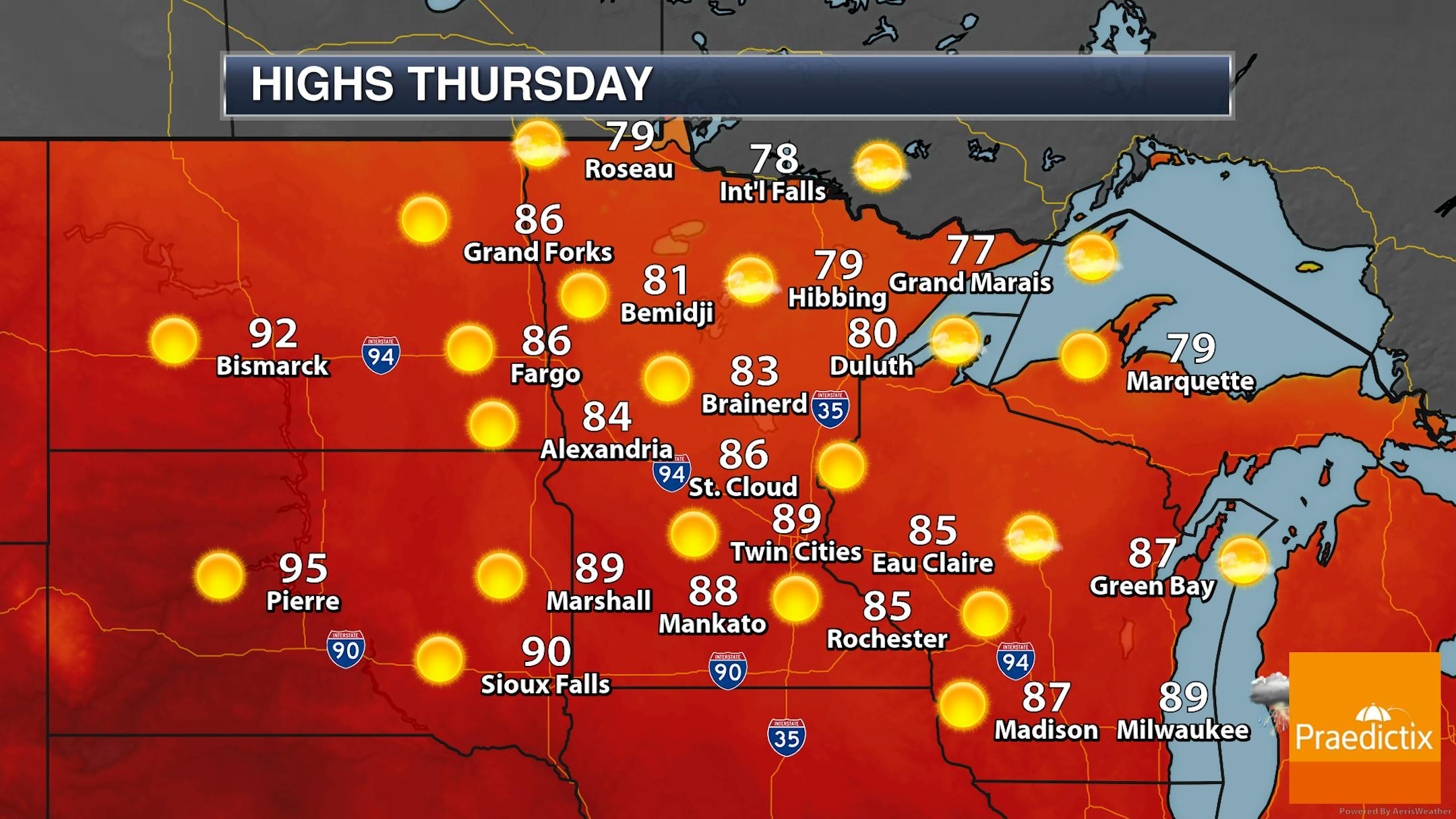
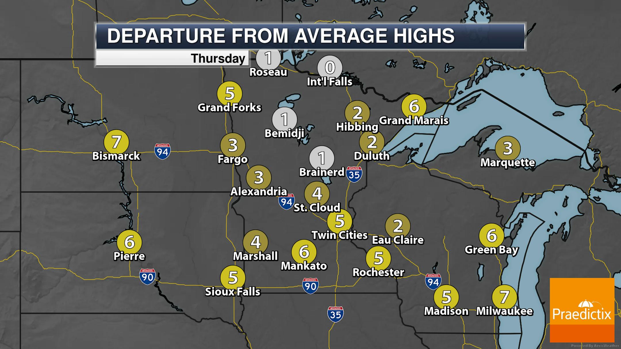
There won't be too much to complain about on Thursday - except maybe the warm temperatures - across the state. Mainly sunny skies are expected regionwide with highs generally in the 70s and 80s. Some areas of southern Minnesota could see highs break the 90F degree mark.

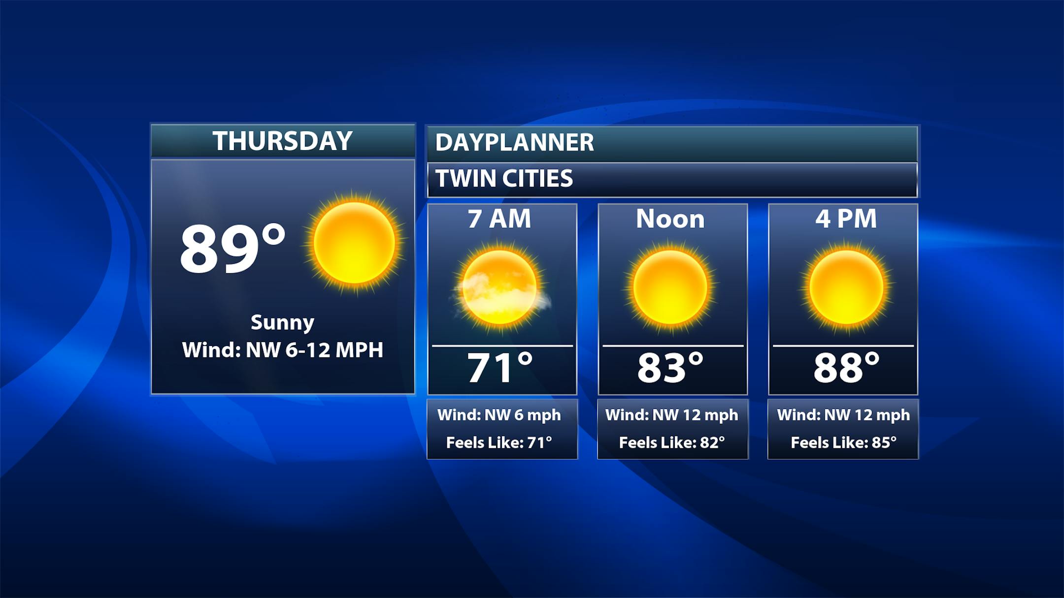
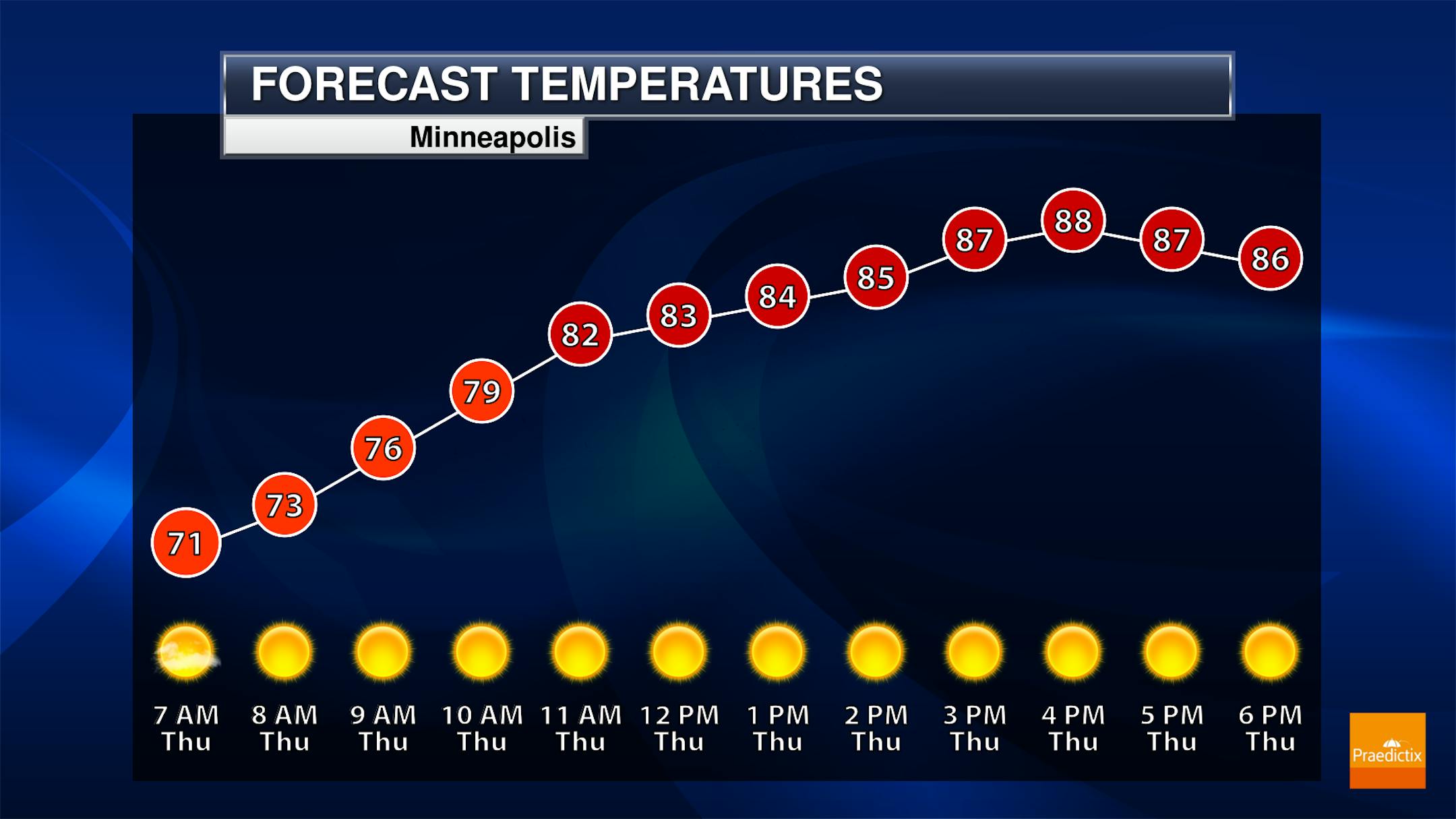
As we look throughout the day in the Twin Cities, morning temperatures will start off around 70F with highs climbing to the upper 80s near 90F.

_______________________________________________

Warm Highs Continue

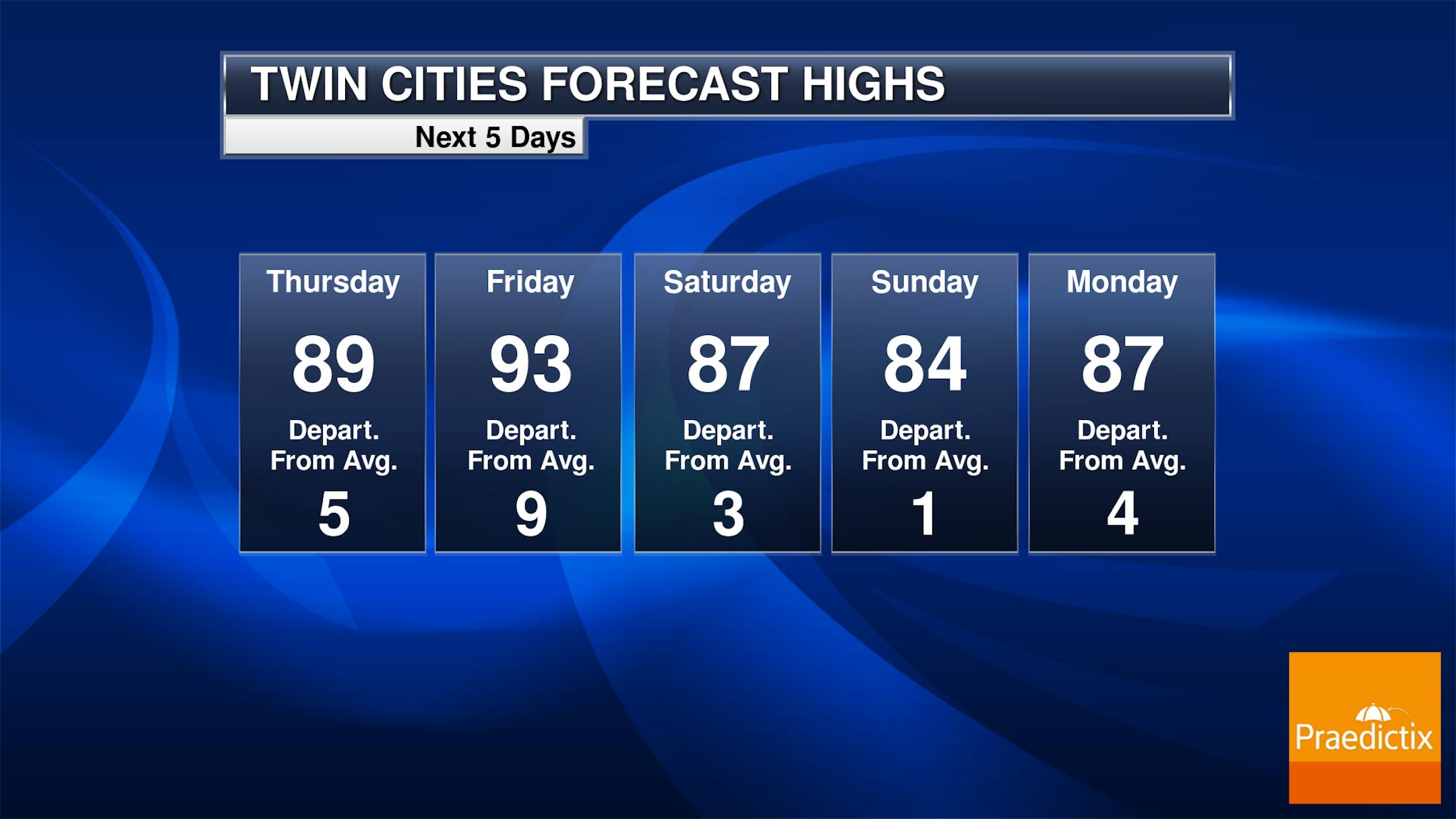
Temperatures will climb even higher on Friday, reaching the low to mid-90s in the Twin Cities before we see a cooling trend into the weekend behind a cold front that moves through Saturday. Highs by Sunday will be in the mid-80s.

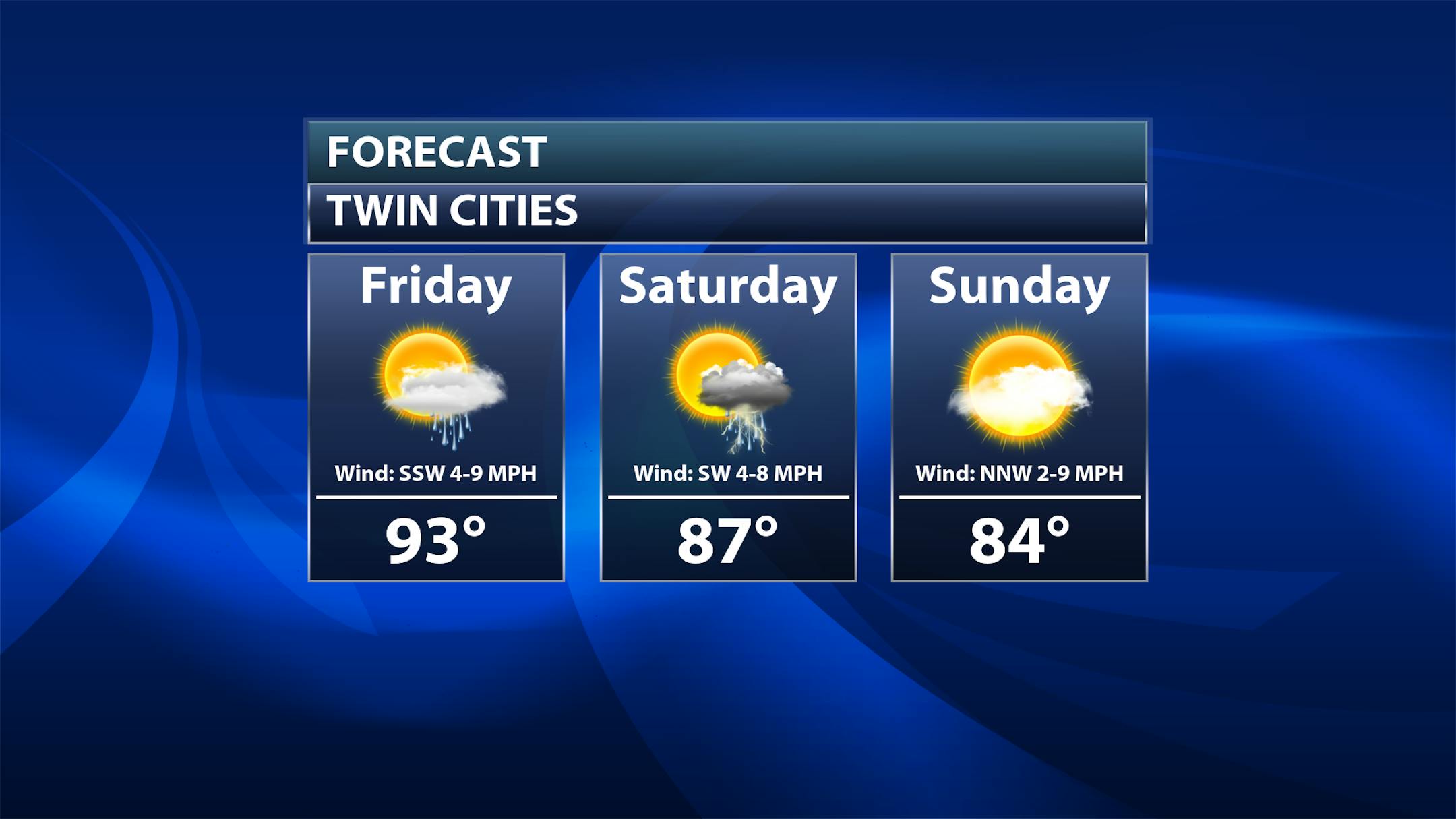
Taking a closer look at Friday and the weekend, we will watch a slight chance of some showers (and maybe a rumble of thunder or two) across southern Minnesota from the Twin Cities southward. A slightly better chance of some rumbles of thunder exists in the Twin Cities Saturday before dry weather is expected Sunday.

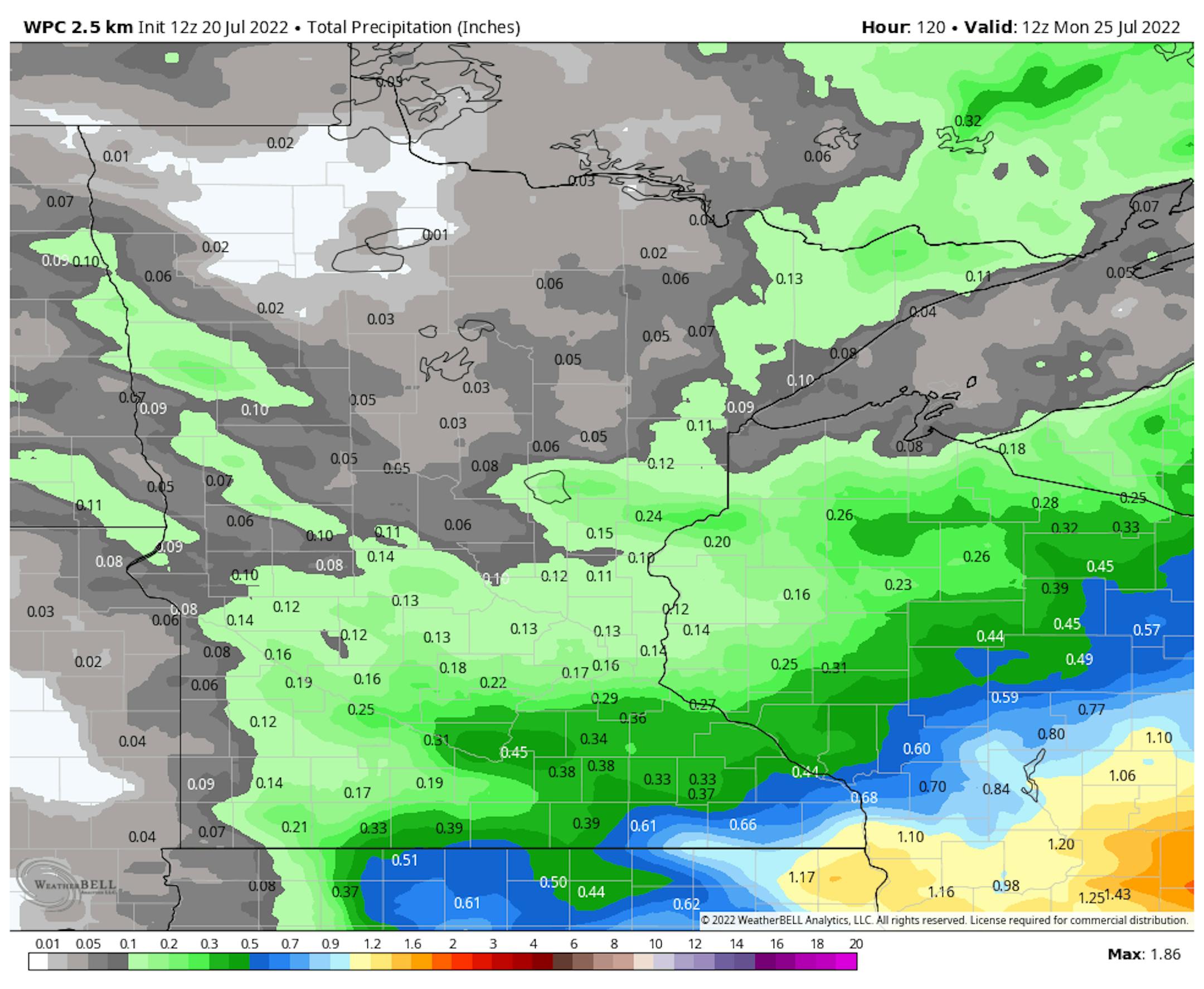
While we could use the rainfall across the metro - and we could see some in the Friday-Saturday timeframe - less than a quarter inch is expected to fall. Heavier rainfall amounts are possible down into far southeastern Minnesota, with the potential of over an inch possible through Monday morning.

_______________________________________________

Severe Threats Friday And Saturday

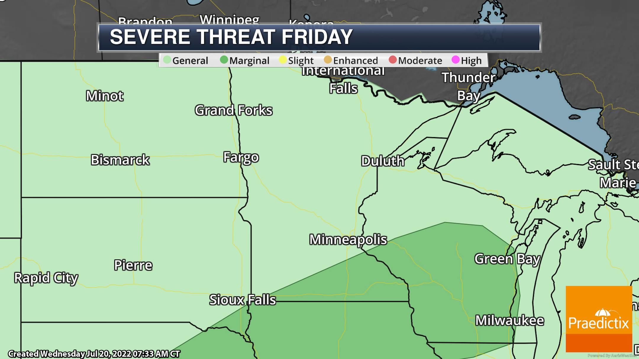
A few of the storms south of the metro both Friday and Saturday could be on the strong side, with a Marginal risk (threat level 1 of 5) in place Friday and the equivalent of a Slight Risk (2 of out 5) on Saturday. Hail and wind will be the primary threats from strong storms on both days, but Saturday could feature more of a damaging wind threat.

_______________________________________________

6-10 Day Temperature Outlook

Meanwhile, a touch of a mixed temperature forecast is potentially on the way for the state as we head toward the end of the month. The 6-10 day temperature outlook, covering the July 25-29 timeframe, shows odds of above average temps across southern Minnesota but below average temps across the Arrowhead. Something to keep an eye on - and at least there would be a part of the state you could head to if you wanted to cool down a touch as forecast highs for this time period in Duluth (up at the airport) may only be in the 70s!

_______________________________________________

Warming Climate Makes Heat Storms More Likely
By Paul Douglas

Leave it to meteorologists to leave you feeling worse than you thought possible. Wind chill. Heat Index. Heat Storms. Say what? The heat spike gripping Europe with all-time records and temperatures 30-40F above average came on suddenly, like a traditional storm.

Extreme heat, gusty winds and low humidity fanned wildfires. Power outages compounded sauna-like misery, bringing back memories of the Pacific Northwest Heat Storm of 2021, and a similar event that left 730 Chicagoans dead in 1995.

We're getting a glimpse of our new normal: bubbles of dangerous, super-heated air unusually far north, amplified by a warming climate.

Expect a comfortable Thursday (dew points in the 50s) with less wind, before low 90s return Friday. The Twin Cities National Weather Service shows a 30-50% rainfall deficit over the southern half of Minnesota since late May. We need 5-6" rain over a month to pull out of drought. The best chance of rain comes Saturday & Tuesday, enough to settle the dust with 80s next week. Sweet relief!

_______________________________________________

Paul's Extended Twin Cities Forecast

THURSDAY: Sunny and breezy. Wake up 70. High 86. Chance of precipitation 10%. Wind NW 10-20 mph.

FRIDAY: Early thunder, then sticky sunshine. Wake up 71. High 92. Chance of precipitation 30%. Wind SW 8-13 mph.

SATURDAY: Showers and T-storms likely. Wake up 76. High 88. Chance of precipitation 80%. Wind SW 8-13 mph.

SUNDAY: Partly sunny and less humid. Wake up 67. High 82. Chance of precipitation 10%. Wind NW 10-15 mph.

MONDAY: Clouds increase. Wake up 67. High 84. Chance of precipitation 20%. Wind SW 7-12 mph.

TUESDAY: A few showers and T-storms. Wake up 71. High 83. Chance of precipitation 60%. Wind W 8-13 mph.

WEDNESDAY: Mix of clouds and sun. No drama. Wake up 65. High 81. Chance of precipitation 10%. Wind NW 10-20 mph.

_______________________________________________

Minneapolis Weather Almanac And Sun Data
July 21st

*Length Of Day: 15 hours, 4 minutes, and 57 seconds
*Daylight LOST Since Yesterday: 1 minute and 56 seconds

*When Do We Drop Below 15 Hours Of Daylight?: July 24 (14 hours, 58 minutes, 52 seconds)
*When Does The Sun Start Rising At/After 6 AM?: August 3rd (6:00 AM)
*When Does The Sun Start Setting At/Before 8:30 PM?: August 8th (8:29 PM)

_______________________________________________

This Day in Weather History
July 21st

2002: Dew points reach 84 degrees at Madison, Morris, and Olivia. This ties the all-time highest dew point reading in Minnesota, as recorded by the State Climatology Office.

1934: Extreme heat hits western Minnesota, and the temperature topped out at 113 at Milan.

_______________________________________________

National Weather Forecast

On Thursday, a couple of cold fronts will be sinking south and east across the central and eastern United States, bringing the potential of showers and thunderstorms with them. Record highs will continue to be possible in parts of Texas.

While most areas of the nation will see under 3" of rain through the end of the week, some of the heaviest rain could fall across portions of the Southeast.

_______________________________________________

Google and Oracle data centers are melting in the UK heat wave

More from Protocol: "Google and Oracle data centers in the U.K. were struggling to operate Tuesday as record high temperatures continue to heat up Europe. According to Google Cloud's service health page, one of its London buildings hosting cloud services for one of its Western Europe regions experienced a "cooling related failure" starting Tuesday morning. The company powered down services in part of that region to fix the issue. Meanwhile, Oracle is having similar issues. Its service health page said it's working to repair the cooling system in its London data center and has powered down some of its services to "to prevent uncontrolled hardware failures." Oracle said it expects service to be restored today."

Extreme rainfall will be worse and more frequent than we thought, according to new studies

More from Grist: "Joshua Studholme was finishing his doctoral program in physics and math at Lomonosov Moscow State University when his thesis advisor told him a story about Queen Victoria, the monarch who ruled the British Empire for the better part of the 19th century. The queen was walking the grounds at one of her palaces, accompanied by a science advisor, when she noticed that it was raining heavily in one corner of her garden but not at all in another corner. She wondered why that was. "Ever since then, imperial meteorologists have been trying to figure out why extreme rainfall can vary so much," said Studholme, who is now a researcher at Yale University. "It's only really now that we're getting the technology to answer that question." Earlier this month, Studholme and three colleagues at Yale published a study that seeks to finetune our understanding of extreme rainfall, now and in the future. They, and other researchers, suspect that the trick to accurately pinpointing the magnitude and frequency of extreme rainfall doesn't just come down to measuring and tracking rain; it also hinges on the way researchers model climate change."

NYC Subway Floods Show Our Transit Systems Are Not Ready for Climate Change

More from Gizmodo: "Torrential rains poured over New York City yesterday, flooding streets, highways, and subway stations. Areas of the city saw record rainfall of around 3 inches in an hour, and Central Park logged the most rain on any July 18 since recordkeeping began in 1869, NY1 reported. The Bronx was one of the most affected areas in the city, and the A train was not running for a few hours while MTA crew members worked to remove water from the train's tracks, NBC4 News reported. ... America's public transit systems are not prepared for the climate crisis. Commutes will become more than just frustrating—getting from point A to point B will more often be downright dangerous. Last September, flash floods in the Washington D.C. area inundated several metro stations and streets, with water flooding platforms and rushing down escalators."

_______________________________________________

Thanks for checking in and have a great day! Don't forget to follow me on Twitter (@dkayserwx) and like me on Facebook (Meteorologist D.J. Kayser).

- D.J. Kayser