Streak of Sunny, Comfortable Days

Welcome to San Diego (north) with a winning streak of sunny days into next week. I see no rain for at least the next 7-9 days, as much as we still need a few good dousings. Expect free A/C into Labor Day with comfortable nights (50s) and daytime highs in the mid-70s. While much of inland California sizzles above 110F. All-time September records will fall in the days ahead. Check the blog for more details. -Todd Nelson

September 3, 2022 at 2:30AM
MN State Fair Friday, September 2nd (@DKayserWX/The Minnesota Star Tribune)

Minnesota State Fair Attendance

According to the MN State Fair, we haven't had any daily records, but it's been there have been a "fair" number of people through the gates this year compared to last year. Note that prior to the pandemic in 2019, there were 6 daily attendance records and a 12 day attendance record of more than 2.1 million visitors!

MN State Fair Attendance Through Thursday (MN State Fair/The Minnesota Star Tribune)

9th Driest Summer at MSP

It's September, which means meteorological summer is behind us and it was a pretty warm and dry summer for the metro. In fact, we just endured the 9th driest (June-July-August) on record in the metro with a little more than 6.5" of rain falling.

15 Driest Summers on Record at MSP (NOAA NWS/The Minnesota Star Tribune)

Beautiful Labor Day Weekend Ahead

Here's the weather outlook from AM Monday to AM Tuesday, which shows dry and mostly sunny weather in place over the long weekend. Temperatures will be comfy along with tolerable humidity values.

Weather Outlook From AM Saturday to AM Tuesday (Tropical Tidbits/The Minnesota Star Tribune)

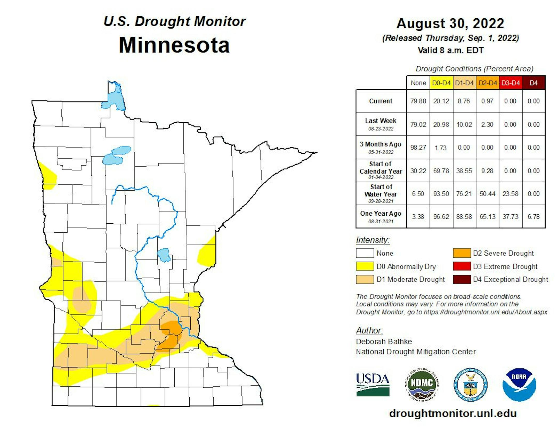
Minnesota Drought Update

Here's the latest drought update across Minnesota. Thanks to a little more rain last week, severe drought has dwindled to less that 1%, but still encompasses a part of the metro. Moderate drought was at nearly 9%.

MN Drought Update (US Drought Monitor/The Minnesota Star Tribune)

Weather Outlook on Saturday

The weather outlook for Saturday shows absolutely stunning weather in place with highs in the 70s across much of the state. A few communities in the Arrowhead will only warm into the 60s with readings nearly -5F below average. Enjoy!

Saturday Weather Outlook (Praedictix/The Minnesota Star Tribune)
Highs From Average on Saturday (Praedictix/The Minnesota Star Tribune)

Weather Outlook Saturday

The weather outlook for Minneapolis on Saturday shows beautiful weather in place much of the day with highs warming into the mid 70s under mostly sunny skies.

Twin Cities Weather Outlook For Saturday (Praedictix/The Minnesota Star Tribune)

Comfy Dewpoints This Weekend

Here's a look at the max dewpoint forecast over the next few days. Very comfy dewpoints will settle in over the weekend with a slight increase in stickiness as we head into early next week.

Max Dewpoints Next Few Days (Praedictix/The Minnesota Star Tribune)

Meteograms for Minneapolis

The hourly forecast for Minneapolis on Saturday shows temperatures starting in the lower upper 50s and warming into the low/mid 70s by the afternoon. It'll be another sunny, but winds won't be too strong. There could be a few gusts around 15mph out of the NNE.

Hourly Temps & Sky Conditions For Minneapolis on Saturday (Praedictix/The Minnesota Star Tribune)
Hourly Wind Gusts & Direction For Minneapolis on Saturday (Praedictix/The Minnesota Star Tribune)

Extended Temperature Outlook For Minneapolis

The extended temperature outlook for Minneapolis shows temps running at or slightly below average this weekend, but things will warm up again as we head through the first full week of September.

5 Day Temperature Outlook For Minneapolis (Praedictix/The Minnesota Star Tribune)

Extended Weather Outlook For Minneapolis

The extended weather outlook over the next 7 days shows pleasant weather in place for the long Labor Day Weekend. We'll then see a gradual warming trend into next week with highs returning to above average levels later in the week. Interestingly, note that we'll generally stay dry through most of next week as well.

7 Day Weather Outlook For Minneapolis (Praedictix/The Minnesota Star Tribune)

Extended Temperature Outlook For Minneapolis

According to the NBM & ECMWF extended temperature outlook shows readings at or below average through the Labor Day Weekend. We'll see a gradual warming trend through the first full week of September as temps get back into the 80s.

NBM Extended Temperature Outlook For Minneapolis (WeatherBell/The Minnesota Star Tribune)
ECMWF Extended Temperature Outlook For Minneapolis (WeatherBell/The Minnesota Star Tribune)

8 to 14 Day Temperature Outlook

According to NOAA's Climate Prediction Center, the 8 to 14 day temperature outlook shows above average temps returning to much of the nation, especially across the eastern two-thirds of the nation.

8 to 14 Day Temperature Outlook (NOAA CPC/The Minnesota Star Tribune)

8 to 14 Day Precipitation Outlook

According to NOAA's Climate Prediction Center, the 8 to 14 Day precipitation outlook shows a better chance of rains across parts of the Central & Southern US.

8 to 14 Day Precipitation Outlook (NOAA CPC/The Minnesota Star Tribune)

Activity in the Atlantic

Here's NOAA's National Hurricane Center 5 day Tropical Outlook from Friday. Interestingly, Danielle in the northern Atlantic became the first hurricane of the 2022 season. Meanwhile, there is another wave that we'll have to monitor as it drifts toward the Bahamas and Bermuda over the next several days.

5 Day Tropical Outlook (NOAA NHC/The Minnesota Star Tribune)

Streak of Sunny, Comfortable Days
By Paul Douglas

Some in our midst are already mourning the loss of summer. To which I say, not so fast. The 90 warmest days of the year marking "Meteorological Summer" are behind us, but more summer heat is inevitable.

NOAA data shows autumn temperatures in the Twin Cities have warmed 4.2F since 1970. Now we see a few days above 90F most Septembers with a rash of 80s- and 70s spilling into October. When I moved here in 1983 ice was usually thick enough for pond hockey by Thanksgiving Day. Now safe ice doesn't arrive until December, most years.

Welcome to San Diego (north) with a winning streak of sunny days into next week. I see no rain for at least the next 7-9 days, as much as we still need a few good dousings. Expect free A/C into Labor Day with comfortable nights (50s) and daytime highs in the mid-70s. While much of inland California sizzles above 110F. All-time September records will fall in the days ahead.

Minnesota weather is rarely boring, but this is one of those moments. Boringly beautiful huh?

Extended Forecast

SATURDAY: Comfortable sunshine. Winds: NE 10-15. High: 74.

SATURDAY NIGHT: Mostly clear & quiet. Winds: ENE 5-10. Low: 53.

SUNDAY: Blue sky with less wind. Winds: E 5-10. High: 75.

MONDAY: Plenty of sunshine. Winds: SE 7-12. Wake-up: 57. High: 78.

TUESDAY: Lukewarm sunshine. Winds: SE 5-10. Wake-up: 56. High: 80.

WEDNESDAY: Sunny streak continues. Winds: E 5-10. Wake-up: 58. High: 82.

THURSDAY: Running out of sunshine symbols. Winds: E 5-10. Wake-up: 63. High: 83.

FRIDAY: Partly sunny and lukewarm. Winds: SE 5-10. Wake-up: 64. High: 83.

This Day in Weather History

September 3rd

1989: An early afternoon thunderstorm dropped 1 3/4 inch hail in Stearns and Morrison Counties.

1980: An F2 tornado results in $2.5 million in property damage, followed by an F3 tornado causing $25 million in damages in Stearns County.

1970: The record-setting hailstone fell that made Coffeyville, KS famous. It had a circumference of 17.5 inches and weighed 1.67 pounds.

1917: An earthquake is felt from Staples to Brainerd.

Average High/Low for Minneapolis

September 3rd

Average High: 77F (Record: 97F set in 1925)

Average Low: 59F (Record: 32F set in 1974)

Record Rainfall: 1.08" set in 1887

Record Snowfall: None

Twin Cities Almanac For September 3rd (Praedictix/The Minnesota Star Tribune)

Sunrise/Sunset Times for Minneapolis

September 3rd

Sunrise: 6:37am

Sunset: 7:46pm

Hours of Daylight: ~13 hours & 8 minutes

Daylight LOST since yesterday: ~ 3 minutes & 1 seconds

Daylight LOST since Winter Solstice (December 21st): ~ 2 hour & 29 minutes

Moon Phase for September 3rd at Midnight

0.5 Days Since First Quarter

Moon Phase For August 3rd at Midnight (The Minnesota Star Tribune)

National High Temps Saturday

The weather outlook on Saturday shows well above average temps across the western half of the nation, where widespread showers record highs will be possible. The dangerous and excessive heat will linger through the long Labor Day Weekend and next week.

National Weather Outlook For Saturday (Praedictix/The Minnesota Star Tribune)
National Highs From Average Saturday (Praedictix/The Minnesota Star Tribune)

National Weather Outlook

Weather conditions through Sunday shows scattered showers and storms across the Southern US. Some of the storms could be strong to severe with locally heavy rainfall.

Weather Outlook Through Sunday (NOAA WPC/The Minnesota Star Tribune)

Extended Precipitation Outlook

According to NOAA's Weather Prediction Center, areas of heavier precipitation will be found across the Southern US, especially in Southern Texas and the Gulf Coast. There will also be pockets of heavy rain in the Eastern US. Meanwhile, much of the Western US will remain dry.

Extended Precipitation Outlook (NOAA WPC/The Minnesota Star Tribune)

Climate Stories

(NOAA/The Minnesota Star Tribune)

"Most major carbon capture and storage projects haven't met targets"

"Several of the world's biggest projects capturing and storing carbon dioxide are significantly underperforming, according to an analysis showing some are capturing only half as much CO2 as promised. Carbon capture and storage (CCS) is seen as a vital tool for tackling climate change by authorities such as the International Energy Agency and the Intergovernmental Panel on Climate Change. The technology stands to receive generous support in the US government's new climate bill, and other countries are incentivising take-up, including Norway and the UK."

"The Summer's Biggest Climate Disasters, Seen from Space"

"Even as someone who writes about climate all the time, it's still a shock to see satellite imagery of climate crises, to really get a grasp on how large human influence can be on our warming planet. Here's how this summer of droughts, heatwaves, floods, and wildfires looked from space. First up, above: Jaw-dropping images of the Cerro Prieto reservoir in northern Mexico show how the reservoir dropped to just 0.5% of its capacity in July, compared to its much fuller state in July 2015. Mexico endured punishing drought conditions this summer, with 21 million people, representing two-thirds of the country, facing some kind of water shortage."

"Greenland's Melting Glaciers Spew a Complicated Treasure: Sand"

"An exotic species known as the zebra mussel, Dreissena polymorpha, a European mollusk, had found the Great Lakes a welcoming new home. Stowing away in the ballast water of a commercial vessel conducting cross-Atlantic trade, the mussels had disembarked in the lakes and, with no natural predators, had rapidly proliferated. And they had found surfaces to which they could cling. Although the interruption of Monroe's public drinking water supply was the first real alert to the general public that a new pest was in town, scientists had already been aware of the invaders. They had discovered the mussels in Lake St. Clair in 1988. But no one had predicted the explosion of zebra mussel populations in such a short time. Soon the species would become the headliner for a Great Lakes problem reaching back into the 1800s—the intentional and unintentional introduction of non-native aquatic organisms."

Thanks for checking in and don't forget to follow me on Twitter @TNelsonWX

@TNelsonWX (The Minnesota Star Tribune)
about the writer

about the writer

Todd Nelson

See Moreicon