Soggy Start Tuesday Gives Way to Midweek Sunshine

We start on a soggy note today with bright sunshine developing by midweek. Unsettled skies return late week with highs warming into the low/mid 80s this weekend. 8 Days until Fall! Check the blog for more details. - Todd Nelson

September 14, 2021 at 2:30AM

Nicholas - 14th Named Storm of the Atlantic Hurricane Season

Tropical Storm Nicholas developed over the weekend in the Gulf of Mexico, which is the 14th named storm of the 2021 Atlantic Hurricane Season. Despite not growing into an intense hurricane, Nicholas will still be problematic for some folks living in Texas and Louisiana, where gusty winds and very heavy rainfall can be expected. Areas of heavy rainfall will lead major flood concerns for some.

Tropical Storm Nicholas on Monday, September 13th (Tropical Tidbits/The Minnesota Star Tribune)

Tracking Nicholas

Here's a look at Nicholas through about midweek as it slowly slides north into the Lower Mississippi Valley. Gusty winds and very heavy rainfall will be the main concerns with Nicholas over the next few days.

Tracking Nicholas (Tropical Tidbits/The Minnesota Star Tribune)

Heavy Rainfall Potential in the Gulf

Rainfall amounts could approaching 10" or more for some along the Texas Coast and into southern parts of Louisiana, where major flooding can't be ruled out.

Rainfall Potential From Nicholas (NOAA NHC/The Minnesota Star Tribune)

Fall Color Tracker

According to the MN DNR, much of the state is already experiencing minor changes in the fall color. Keep in mind that much of the summer was hot and dry, so some of the trees are a bit stressed and could be prematurely changing. With that being said, we are getting closer to that time of the year. See the latest update from the MN DNR HERE:

Fall Color Update (MN DNR/The Minnesota Star Tribune)

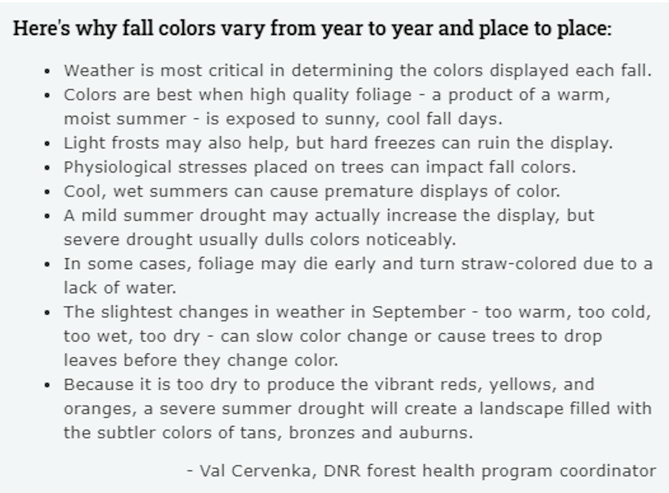
Fall Color Depends on Weather

Ever wonder why some years, fall color is so vibrant vs some years, fall color tends to be a bit more dull? Val Cervenka, Coordinator from the DNR Forest Health Program, shares how the weather can play a roll in those fall colors. Due to the hot and dry summer that most of experienced, it is likely that fall foliage could be less impressive this year with more tans, bronzes and auburns.

Fall Color & Weather (MN DNR/The Minnesota Star Tribune)

Typical Peak Dates For Fall Color

According to the MN DNR, fall colors typically start to peak across the northern part of the state in mid/late September. Peak color typically arrives in central and southern Minnesota late September and into early/mid October. Note that over the next several weeks, you'll notice some big changes in the landscape as we head deeper into fall.

Typical Fall Color Peak (MN DNR/The Minnesota Star Tribune)

"Greenland Pummeled By Snow One Month After Its Summit Saw Rain For The First Time"

"Just a month after rainfall was recorded for the first time ever at Greenland's highest point, the island is expecting up to four feet of snow from the remnants of Hurricane Larry — the rare tropical storm to stay intact so far north. Hurricane-force gusts topped 100 miles per hour at Kulusuk Airport near Greenland's southeast coast. At Tasiilaq, the largest town in the region, sustained winds reached 55 miles per hour, with gusts of over 90. The snow reached blizzard conditions at Summit Camp, a weather station at the island's highest point more than 10,000 feet above sea level, with winds and snow so heavy that visibility was minimal. "Ex-hurricane Larry is still haunting us," the Danish Meteorological Institute wrote. The winds and precipitation — rain in some places along the coast, snow further inland — were expected to last into Monday. The "post-tropical cyclone," the longest-lasting of this year's Atlantic hurricane season, neared Greenland a day after making landfall in Newfoundland, Canada, as a Category 1 storm, where it blew down trees and knocked out power for tens of thousands of residents."

Snow in Greenland (Summit Camp Webcam/The Minnesota Star Tribune)

Active Tropics Continue

Keep in mind that the peak of the Atlantic Hurricane season is on September 10th and things are still quite active in the Atlantic basin now. Along with Nicholas, NOAA's NHC is tracking 2 other waves, 1 of which have a high probability of tropical formation over the next 5 days. The area of interest will drift north and should stay east of the US Mainland, but stay tuned...

5 Day Tropical Outlook (The Minnesota Star Tribune)

Minnesota Drought Update

According to the latest drought update from the US Drought Monitor, drought continues to slightly improve across the state. From last week to this week, there were slight improvements in the D3 (extreme) and D4 (exceptional) categories. The worst of the drought still remains across the northern tier of the state with moderate to severe drought across much of the Twin Cities metro.

Minnesota Drought Update (US Drought Monitor/The Minnesota Star Tribune)

Precipitation Departure From Average Since Jan. 1st

Despite picking up some much needed rainfall at the end of August, many locations are still several inches below average since January 1st. Some of the biggest deficits are still across the northern half of the state, where Exceptional Drought conditions are in place. The Twin Cities is still -3.70" below average and at its 64th driest January 1st to September 12th on record.

Precipitation Departure From Average Since January 1st (Praedictix/The Minnesota Star Tribune)

Simulated Radar From AM Tuesday to AM Wednesday

Here's the simulated radar from AM Tuesday to AM Wednesday, which shows areas of heavy rainfall from PM Monday moving quickly east on Tuesday. Things will dry out quite a bit during the day Tuesday, but there could be a few isolated showers in the afternoon.

Simulated Radar From AM Tuesday to AM Wednesday (WeatherBell/The Minnesota Star Tribune)

Weather Outlook for Tuesday

The weather outlook for the Twin Cities on Tuesday, September 14th, could be a little damp in the morning with lingering low clouds, but things will slowly clear as we head throughout the day. With that being said, we can't rule out a very isolated shower in the afternoon.

Tuesday Weather Outlook For Minneapolis (Praedictix/The Minnesota Star Tribune)

Minneapolis Meteograms

The meteograms for Minneapolis on Tuesday shows temps warming from the lower 60s in the morning to the lower 70s by the afternoon. There could be a few isolated showers early in the day, but much of the day will be dry with NW winds gusting close to 15mph-20mph.

Hourly Temps & Sky Conditions For Minneapolis on Tuesday (Praedictix/The Minnesota Star Tribune)
Hourly Wind Gusts & Direction For Minneapolis on Tuesday (Praedictix/The Minnesota Star Tribune)

Regional Weather Outlook for Tuesday

The weather outlook across the region on Tuesday shows near average temps with highs warming into 60s and 70s across the state. Most of the rain will push east early in the day with drier conditions building in through the afternoon/evening.

Weather Outlook For Tuesday (Praedictix/The Minnesota Star Tribune)
Highs From Average on Tuesday (Praedictix/The Minnesota Star Tribune)

Extended Weather Outlook for Minneapolis

The extended weather outlook for Minneapolis shows near average temperatures through midweek. Warmer temps arrives Thursday & into the weekend with highs around 80F, which will be nearly +10F above average for mid September. Showers and storms will be possible once again later this week and again Sunday night into Monday.

5 Day Temperature Outlook for Minneapolis (Praedictix/The Minnesota Star Tribune)
7 Day Weather Outlook (Praedictix/The Minnesota Star Tribune)

8 to 14 Day Temperature Outlook

According to NOAA's Climate Prediction Center, the 8 to 14 day temperature outlook shows warmer than average temps across much of the eastern two-thirds of the nation. Cooler than average temps will be found in the Pacific Northwest and into Alaska.

8 to 14 Day Temperature Outlook (NOAA Climate Prediction Center/The Minnesota Star Tribune)

Soggy Start Tuesday Gives Way to Midweek Sunshine
By Todd Nelson, filling in for Douglas.

Ahh, the sweet sound of the September Cicada. Interestingly, it is one of the loudest insects in the world. Researchers determined that this year's 'Brood X' that emerged across eastern parts of the nation, were able to reach noise levels up to 100 decibels, which is like standing next to a Harley.

Folklore suggests that the first buzz of the late summer cicada will determine your first frost 6 weeks later. Note that the earliest frost on record at MSP Airport was on September 3rd, 1974. Last year our first frost was recorded on October 4th, while our average is October 13th.

Going further down the rabbit hole, on this date back in 1964, Minnesota recorded its earliest measurable snowfall of 0.3 inches at International Falls! Also, on this date in the year 2099, there will be a total solar eclipse visible in Minnesota, but that's a story for another time.

We start on a soggy note today with bright sunshine developing by midweek. Unsettled skies return late week with highs warming into the low/mid 80s this weekend. 8 Days until Fall!

Extended Forecast

TUESDAY: Partly sunny. PM shower? Winds: SSE 5-10. High: 73.

Tuesday Night: Mostly clear and quiet. Winds: WNW 5. Low: 53.

WEDNESDAY: Bright sun, comfy temps. Winds: NNW 5-10. High: 75.

THURSDAY: Breezy PM. Late day shower or storm. Winds: SSW 10-20. Wake-up: 60. High: 81.

FRIDAY: Lingering T-storms southern Minnesota. Winds: SSW 5-10. Wake-up: 63. High: 75.

SATURDAY: Damp start. Sunny skies by afternoon. Winds: SSW 5-10. Wake-up: 60. High: 81.

SUNDAY: Dry & Mild. Late day rain & rumbles. Winds: WNW 7-12. Wake-up: 68. High: 82.

MONDAY: Scattered storms early. Clearing late. Winds: WNW 10-20. Wake-up: 68. High: 83.

This Day in Weather History

September 14th

2099: The next total solar eclipse will take place over Minnesota. It will be visible in the Twin Cites, depending on the weather.

1964: The earliest official measurable snowfall occurs in Minnesota with 0.3 inches at International Falls.

1852: Early frost hits Ft. Snelling and ends the growing season.

Average High/Low for Minneapolis

September 14th

Average High: 73F (Record: 98F set in 1939)

Average Low: 53F (Record: 33F set in 1996)

Record Rainfall: 1.60" set in 1994

Record Snowfall: 0.0"

Twin Cities Almanac For September 14th (Praedictix/The Minnesota Star Tribune)

Sunrise/Sunset Times for Minneapolis

August 14th

Sunrise: 6:51am

Sunset: 7:25pm

Hours of Daylight: ~12 hours & 34 minutes

Daylight LOST since yesterday: ~ 3 minute & 5 seconds

Daylight LOST since Summer Solstice (June 20th): ~3 Hour & 3 Minutes

Moon Phase for September 14th at Midnight

1.4 Days Since First Quarter Moon

Moon Phase for September 14th at Midnight (Todd Nelson/The Minnesota Star Tribune)

What's in the Night Sky?

"The moon passes 4 degrees N. of Saturn on September 17, 2021, at about 3 UTC. It passes 4 degrees N. of Jupiter on September 18 at 7 UTC. On any of these evenings – September 15 to 18, 2021 – the moon can guide you to these 2 outer solar system worlds. By the way, though we show Pluto on our chart, it's about 1,000 times too faint to be viewed with the eye alone. Moon, Saturn, Jupiter - On September 2021 evenings, the moon, Saturn and Jupiter are still visible almost everywhere worldwide (except the far-northern Arctic) as night falls. Jupiter is the brighter of the two planets. And, as it's done for some months now, Jupiter follows Saturn westward across the night sky as Earth turns. Both of these worlds passed their oppositions in August. In September 2021, you'll find them already in the east after sunset. They'll set in the wee hours between midnight and dawn. The moon will sweep closest to bright Jupiter on the North American evening of September 17 (September 18 at about 7 UTC). That'll be the most spectacular evening to watch for them. But any night from September 15 to 18 will be fine for looking outside. On these evenings, the moon can guide you to Jupiter and Saturn."

Night Sky For Mid September (Earth Sky/The Minnesota Star Tribune)

Dixie Fire in Northern California

The #DixieFire is the 2nd largest fire in California's history burning nearly 960,000 acres as of September 13th. The fire is 75% contained and has burned more than 1,300 structures. The largest wildfires in the state's history was the August Complex from 2020, which burned more than 1 million acres.

Dixie Fire in Northern California (Inciweb/The Minnesota Star Tribune)
Dixie Fire Map (Inciweb/The Minnesota Star Tribune)

Largest Wildfires in California State History

Here's a list of California's Top 20 Largest Wildfires in the state's history. Note the Dixie Fire is still ongoing and it the 2nd largest wildfire on record. The Caldor fire is nearly 219,000 acres a is currently the state's 15th largest fire in history. The Monument Fire is also currently active, burning almost 207,000 acres as is the 16th largest fire in California history.

Top 20 Largest Wildfires in CA State History (Cal Fire/The Minnesota Star Tribune)

National High Temps Tuesday

The weather outlook on Tuesday shows well above average temperatures east of the Mississippi River with showers and storms possible in the Central US. Hot temps will also continue in the Southwest, where readings will be in the 100s, including Phoenix.

Weather Outlook For Tuesday (Praedictix/The Minnesota Star Tribune)
Highs From Average on Tuesday (Praedictix/The Minnesota Star Tribune)

National Weather Outlook

The national weather outlook through midweek shows somewhat unsettled weather across the northern tier of the nation with pockets of heavy rainfall. There will also be heavy rains across the southern US, as Nicholas slowly moves through.

Weather Outlook Through Wednesday (NOAA Weather Prediction Center/The Minnesota Star Tribune)

Extended Precipitation Outlook

According to NOAA's Weather Prediction Center heavier precipitation potential will be found across parts of the eastern US and especially in the south, where Nicholas moves through. There will also be some heavier amounts in the Pacific Northwest over the coming days.

Extended Precipitation Outlook (NOAA Weather Prediction Center/The Minnesota Star Tribune)

Climate Stories

(NOAA/The Minnesota Star Tribune)

"Are giraffes more at risk of being struck by lightning?"

Giraffes and lightning are both rare but lightning strikes on giraffes aren't unheard of. Despite being around five metres tall, giraffes are very unlikely to get struck by lightning. But this is mainly because lightning and giraffes are both fairly rare. There are only five well-documented fatal strikes on giraffes between 1996 and 2010. With a global giraffe population of around 140,000 in that period, this is about 0.003 deaths per thousand giraffes per year. That's a very low risk, but it's still more than 30 times the equivalent fatality rate from lightning in humans in the US.

"The world turns sideways in trippy, glowing Earth photo from the International Space Station"

City lights cling to a tilted Earth as orange atoms slice through space in a stunning, surreal new photo taken aboard the International Space Station (ISS). Thomas Pesquet, a French astronaut who arrived at the ISS for his second spaceflight in April 2021, captured the trippy image on July 30 while taking in the view from the space station's cupola — a domed, seven-windowed observation room that peeps out of the station's side. Looking out at Earth, Pesquet was particularly taken by the interplay of man-made and celestial light before him, the European Space Agency astronaut wrote in a post on Flickr.

"Ancient sea ice core sheds light on modern climate change"

"A 170 m record of marine sediment cores extracted from Adélie Land in Antarctica by the Integrated Ocean Drilling Programme is yielding new insights into the complicated relationship between sea ice and climate change. In a new study published in Nature Geoscience, researchers at the University of Birmingham, have collaborated in an international project to identify how fluctuations in sea ice levels have interconnected with both algae blooms and weather events linked to El Nino over the past 12,000 years. They found that Antarctic winds strongly affect the break-out and melting of sea ice, which in turn affects the levels of algae which can grow rapidly in surface waters when sea ice is reduced. Changes in the levels of algae growth in the waters surrounding the Antarctic are important enough to affect the global carbon cycle."

Thanks for checking in and don't forget to follow me on Twitter @TNelsonWX

@TNelsonWX (The Minnesota Star Tribune)
about the writer

about the writer

Todd Nelson

See Moreicon