Slowly Falling Temperatures Monday - Any Snow Chances Before Christmas?

After a cold front moves through Sunday Night, we'll see falling temperatures and feels like temperatures in the single digits as we head through Monday. A snow chance moves across northern Minnesota Monday Night into Tuesday, but will there be any snow chances before Christmas here in the metro? - D.J. Kayser

December 20, 2021 at 12:00AM
(The Minnesota Star Tribune)

Seven Tornadoes From Last Wednesday In Minnesota

(The Minnesota Star Tribune)

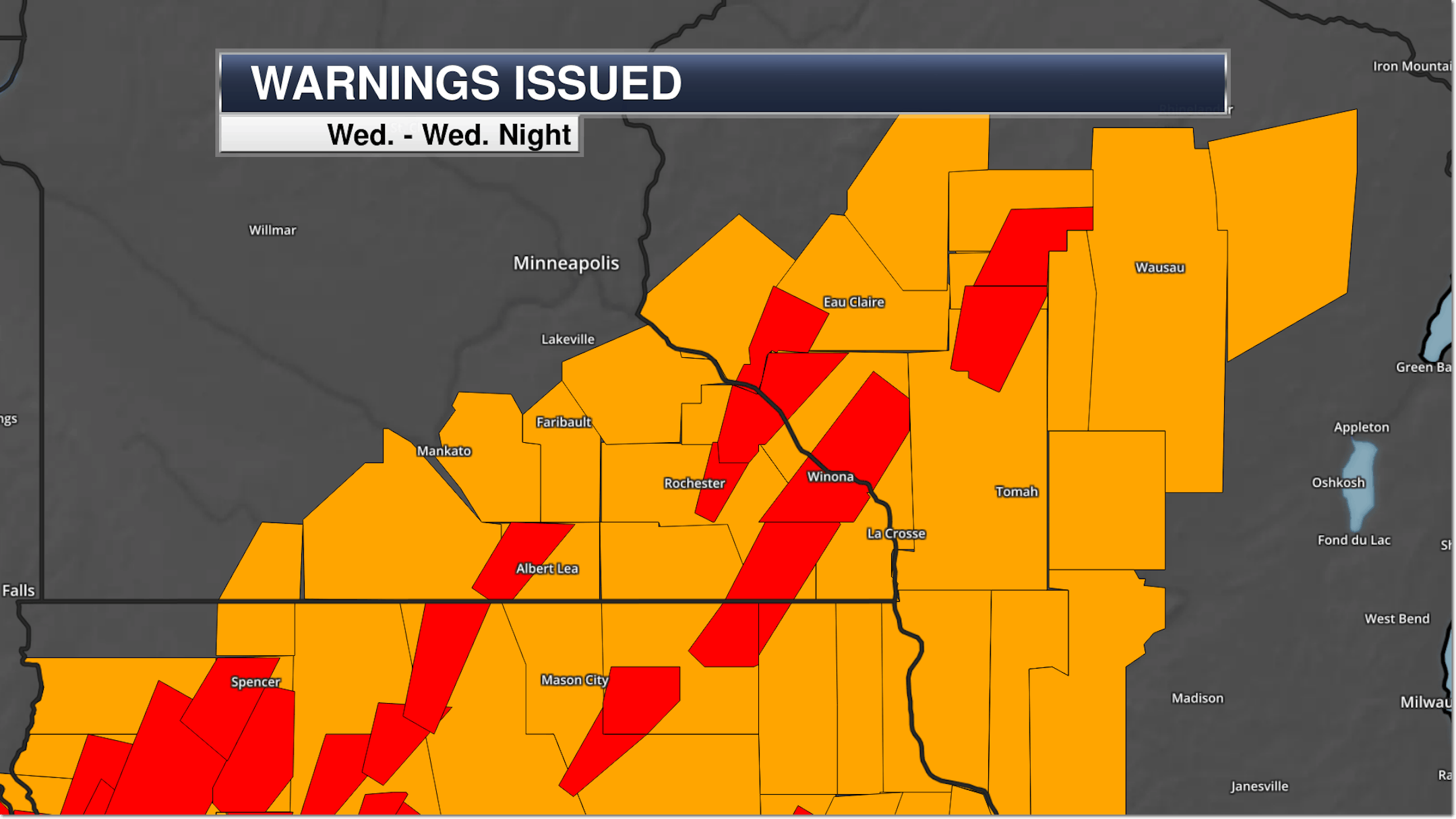
Between damage surveys completed between the National Weather Service offices in both the Twin Cities and La Crosse, they have now found seven tornado touchdowns in the state from our historic mid-December storm last Wednesday evening. Here are where those tornados were:

  • Two EF-1 tornadoes near Alden (one at 6:56 PM, the other at 7:03 PM)
    • An EF-2 in Hartland (7:10 PM)
      • An EF-0 in Preston (7:43 PM)
        • An EF-1 in Carrolton (7:45 PM)
          • An EF-1 near Plainview (8:02 PM)
            • An EF-0 near Lewiston and Wyatteville (8:09 PM)

              Remember that this marks the first time in recorded history that there have been tornadoes in the month of December in Minnesota. The Minnesota State Climatology Department has a write-up on the storm, and Mark Seeley has more in his WeatherTalk blog about the storm including the record highs set.

              _______________________________________________

              Monday Weather Outlook

              (The Minnesota Star Tribune)
              (The Minnesota Star Tribune)

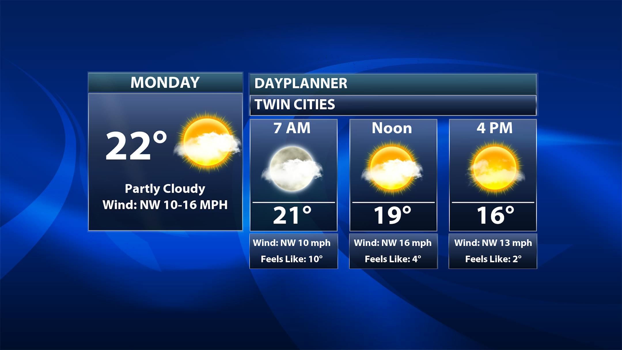
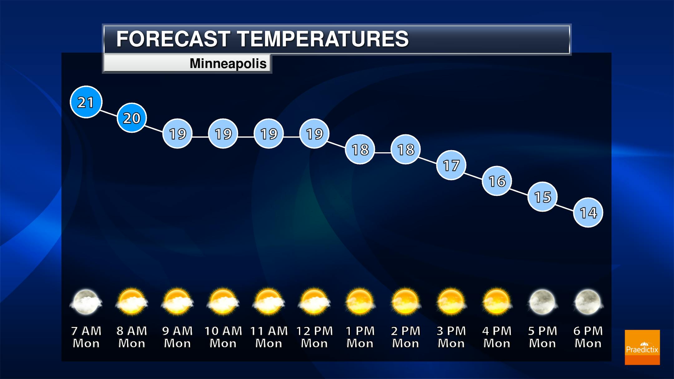
              Due to a cold front moving across the region Sunday Night, highs will be set early Monday with otherwise dropping temperatures throughout the day in the Twin Cities. The good news is that we will see mostly sunny skies.

              (The Minnesota Star Tribune)

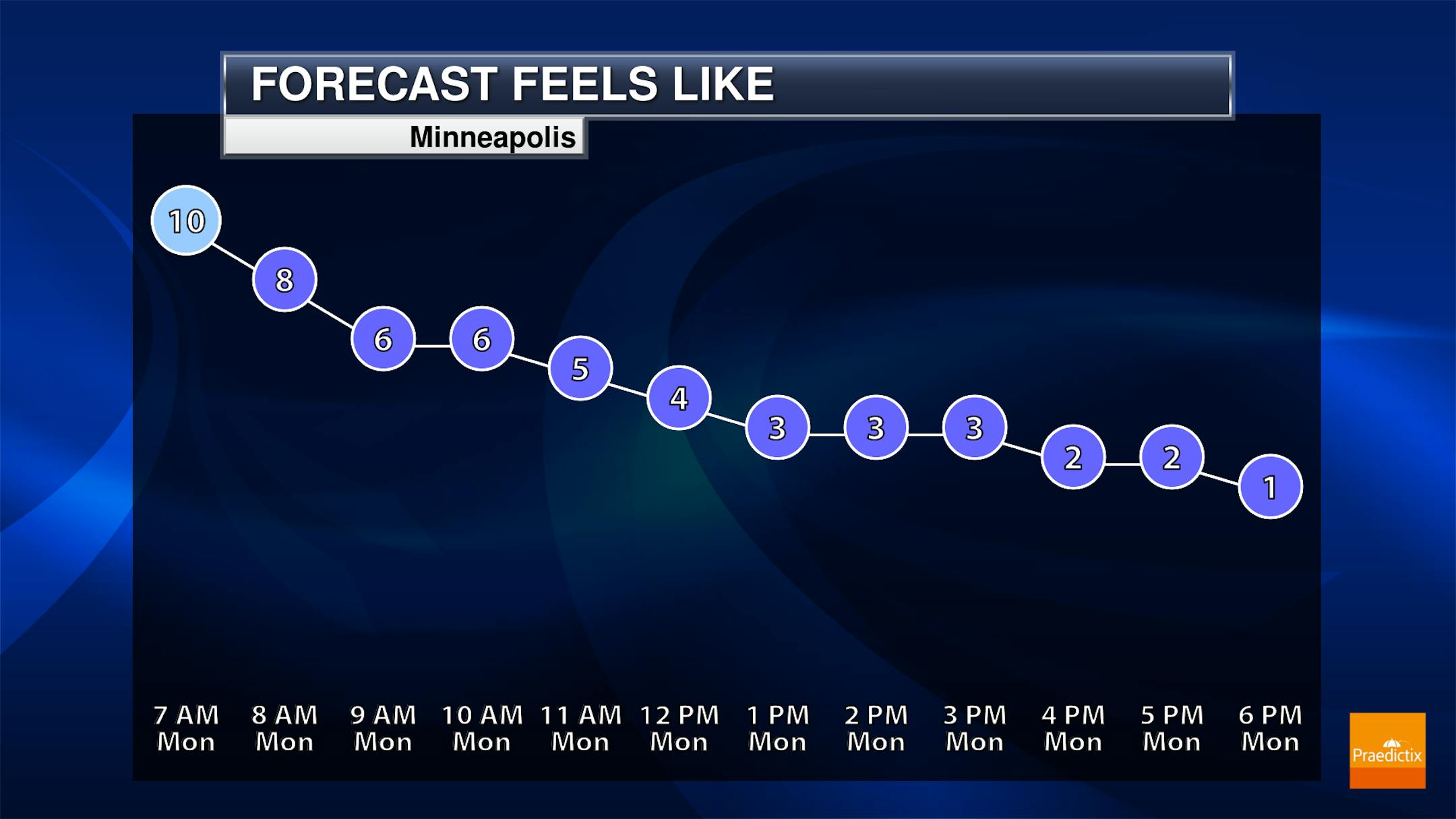
              With breezy northwest winds between 10-15 mph, those temperatures in the teens and 20s will feel more like the single digits throughout much of the day.

              (The Minnesota Star Tribune)
              (The Minnesota Star Tribune)

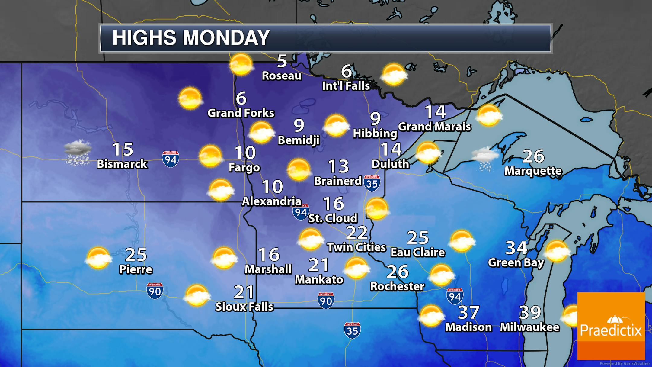
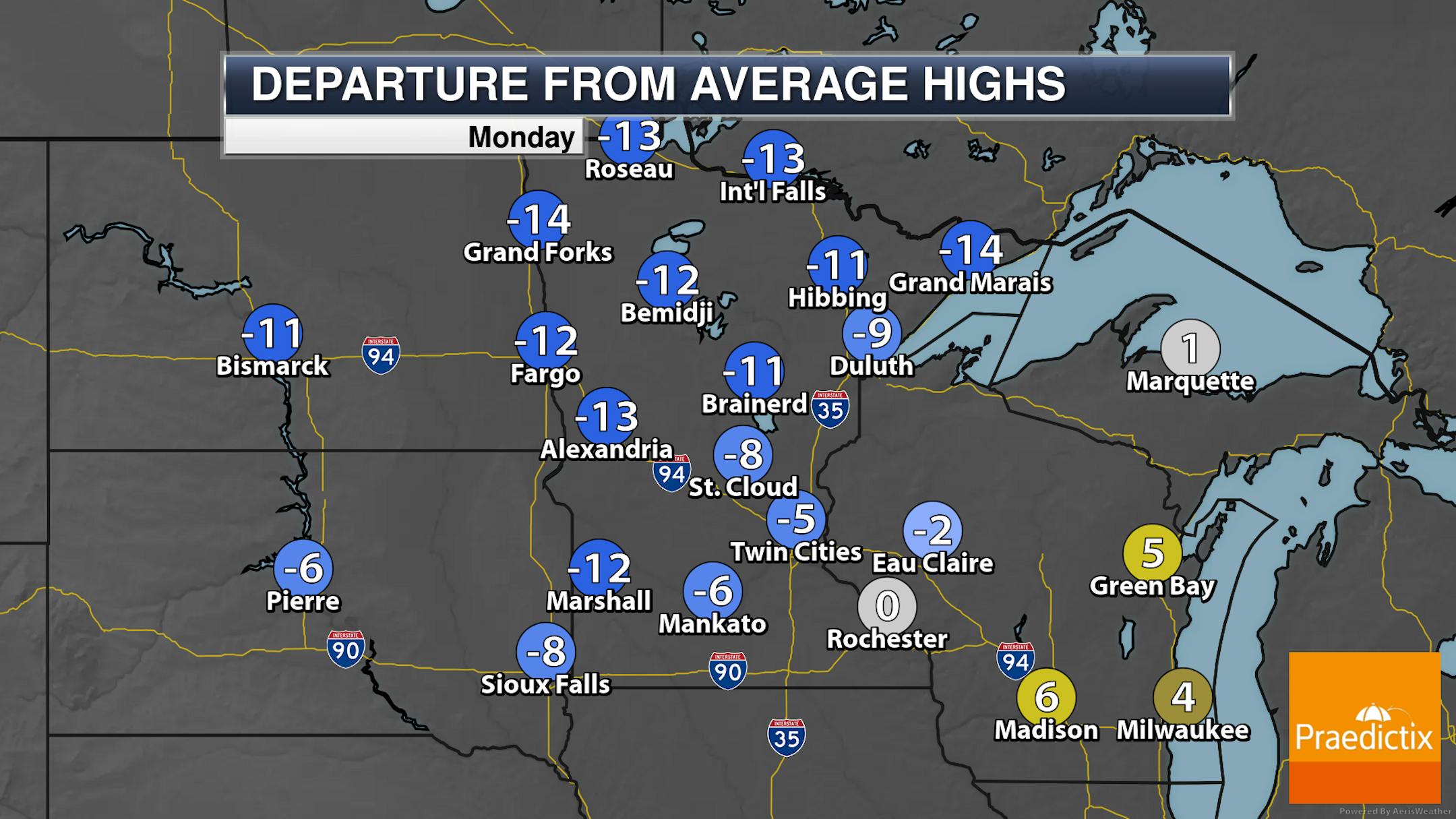
              Looking statewide Monday, we'll see a mix of sun and clouds to mainly sunny skies with highs generally below average - up to 15F in some areas. Highs in northern Minnesota will only be in the single digits above zero, with some 20s in southern Minnesota (generally set earlier in the day).

              _______________________________________________

              Snow Chance North Monday Night Into Tuesday

              (The Minnesota Star Tribune)

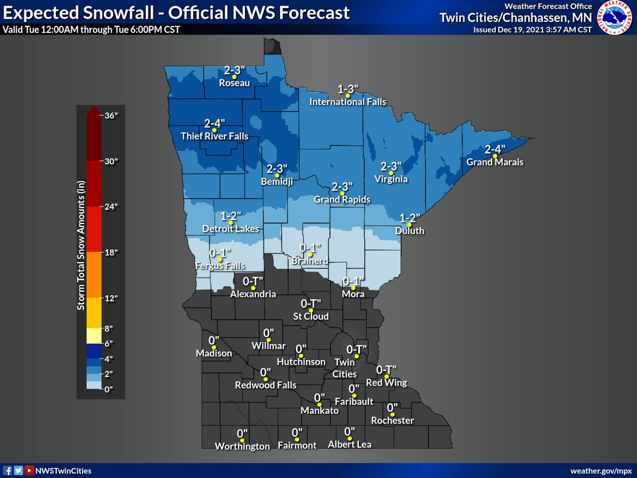
              As we head into Monday night and Tuesday, an area of low pressure moving through the upper Midwest will help produce some snow chances mainly across the northern half of the state. The heaviest snowfall amounts - up to 4" - are expected in northwestern parts of Minnesota, isolated areas of the Arrowhead, and along northern portions of North Shore.

              _______________________________________________

              Weather Leading Up To Christmas

              (The Minnesota Star Tribune)

              The good news is in the lead-up to Christmas on Saturday (get that last-minute shopping done!) there won't be any bitterly cold highs to deal with in the Twin Cities - in the 20s through Wednesday before climbing into the low 30s for the end of the week.

              (The Minnesota Star Tribune)
              (The Minnesota Star Tribune)
              (The Minnesota Star Tribune)

              The big question many people may be asking is if there will be any new snow before Christmas? The best chance of that will be across northern Minnesota, where there is expected snow Monday Night into Tuesday and then a few other lighter chances toward the end of the week. While you do see snow icons toward the end of the week farther south here into southern Minnesota, I think those chances are currently slight as there are major differences in the models as to whether or not we get precipitation... and with temperatures at least near freezing (or potentially above it if you buy into some of the model forecast temperatures toward the end of the week), precipitation type forecasting could also be tricky.

              _______________________________________________

              Metro Rain/Ice For Christmas Eve This Year
              By Paul Douglas

              According to CBS's 60 Minutes, "The Beast", an EF-4 tornado that tracked 165 miles across Kentucky on December 10, may have destroyed 15,000 buildings at a cost of $3.5 billion.

              It's surreal that Minnesota's biggest tornado outbreak of 2021 came last Wednesday, with 7 confirmed touchdowns. The preliminary tornado count for all of 2021 in Minnesota is 29, lower than average, due to historic heat and drought.

              The northern half of Minnesota will experience a white Christmas, but south of a line from Willmar to the Twin Cities, not so much. A coating of snow is possible at MSP Tuesday, with 2-5" over roughly the northern half of Minnesota, but daytime temperatures rise into the 30s the latter half of this week, and models show rain on Christmas Eve, with light icing possible. Santa may need his rain-deer this year over southern counties, but models suggest a better chance of a few snowy encounters next week.

              I'm waiting for a sustained polar punch but no prolonged subzero ordeals are in sight...yet.

              _______________________________________________

              Paul's Extended Twin Cities Forecast

              MONDAY: Partly sunny, brisk. Wake up 18. High 21. Chance of precipitation 10%. Wind NW 10-20 mph.

              TUESDAY: Coating of flakes, few inches up north. Wake up 10. High 26. Chance of precipitation 50%. Wind NW 10-20 mph.

              WEDNESDAY: More clouds than sun, milder. Wake up 13. High 31. Chance of precipitation 10%. Wind S 10-20 mph.

              THURSDAY: Intervals of sun, thawing out. Wake up 23. High 36. Chance of precipitation 10%. Wind SE 5-10 mph.

              FRIDAY. Rain arrives, a little glaze ice early. Wake up 32. High 40. Chance of precipitation 70%. Wind SE 10-20 mph.

              SATURDAY: Partly sunny and cooler. Wake up 21. High 27. Chance of precipitation 10%. Wind NW 10-20 mph.

              SUNDAY: Cloudy with flurries. Wake up 13. High 29. Chance of precipitation 40%. Wind NE 8-13 mph.

              _______________________________________________

              Minneapolis Weather Almanac And Sun Data
              December 20th

              (The Minnesota Star Tribune)

              *Length Of Day: 8 hours, 46 minutes, and 13 seconds
              *Daylight LOST Since Yesterday: 6 seconds

              *Day With Least Sunlight: December 21st (8 hours, 46 minutes, and 11 seconds)
              *Latest Sunrises Before We Start Gaining Morning Light: 7:51 AM between December 30th and January 5th
              *Next Sunset At/After 5 PM: January 17th (5:00 PM)

              _______________________________________________

              This Day in Weather History
              December 20th

              1989: Minnesotans are hard pressed to find snow cover across most of the state. Only good places to cross country ski are at Grand Marais and along the Gunflint Trail.

              _______________________________________________

              National Weather Forecast

              (The Minnesota Star Tribune)
              (The Minnesota Star Tribune)

              Looking at the Monday before Christmas across the lower 48, a system off the west coast will bring rain and snow chances to portions of the Northwest south into the Bay Area. A low that'll be working from the Northern Rockies to the upper Midwest by Tuesday will bring snow chances spreading east across the Northern Plains. A frontal system could bring portions of New England snow, and a system across the Southeast will bring shower and storm chances.

              (The Minnesota Star Tribune)

              The heaviest snow will be across portions of the Northern Rockies and Cascades where at least a foot or two of snow could fall. The heaviest rain will be across portions of Oregon with at least three inches possible in some areas. However, at least 1-2" of rain could also fall across the Southeast.

              _______________________________________________

              Climate change is shrinking the odds of a white Christmas, this year included

              More from the Capital Weather Gang: "The unforgettable lyric to Irving Berlin's classic holiday song may need a rewrite: "I'm dreaming of a warm Christmas, unlike the ones I used to know" … Exceptionally mild weather dominating the Lower 48 this month shows little sign of meaningful change through the Christmas holiday. This means rather underwhelming chances for a white Christmas in many parts of the United States, a state of affairs to which we probably should become accustomed. Our warming climate appears to be eating away at white Christmas chances, newly available data shows."

              The "Doomsday Glacier" may partially collapse. If it does, Earth's sea level will rise by 2 feet

              More from Salon: "The widest glacier on the planet — nicknamed the "Doomsday Glacier" because its collapse could trigger a chain of events resulting in millions of people being permanently flooded out of their homes and becoming climate refugees — is showing signs of collapse. It's called the Thwaites Glacier, and it is the size of Florida. And what happens to it in the next few years could radically alter the future of human (and Earth) history. Located in western Antarctica, Thwaites Glacier currently empties 50 billion tons of ice into the ocean every year. As a result, the glacier is already responsible for roughly four percent of the planet's annual sea level rise. That's because when it warms enough to belch ice into the water, that ice slowly melts, causing the overall volume of water in the ocean to increase."

              Midwest lags, though Madison and Minneapolis shine in national clean energy policy ranking

              More from Energy News Network: "Madison, Wisconsin's clean transportation investments helped propel it ahead in an annual ranking of clean energy and energy efficiency plans. The analysis of 100 major cities by the American Council for an Energy-Efficient Economy (ACEEE) revealed that nationwide, cities are largely not on track to meet their own greenhouse gas reduction goals, and/or they don't collect data that would allow them to meaningful log such emissions reductions. ACEEE rated cities on building sustainability, renewable energy, transportation, government initiatives and community impact. Overall, Midwestern cities lagged behind the coasts, with only three cities in the region ranking in the top 20: Minneapolis at 4th, Chicago at 12th, and St. Paul at 20th. Madison, at 39th, was the most improved city nationwide, while Milwaukee dropped significantly from last year's report to 53rd."

              _______________________________________________

              Thanks for checking in and have a great day! Don't forget to follow me on Twitter (@dkayserwx) and like me on Facebook (Meteorologist D.J. Kayser).

              - D.J. Kayser

              (The Minnesota Star Tribune)
              about the writer

              about the writer

              D.J. Kayser

              See Moreicon

              More from No Section (Assign Gallery and Videos here)

              See More