"Pacific Northwest faces one of its most severe heat waves in history"

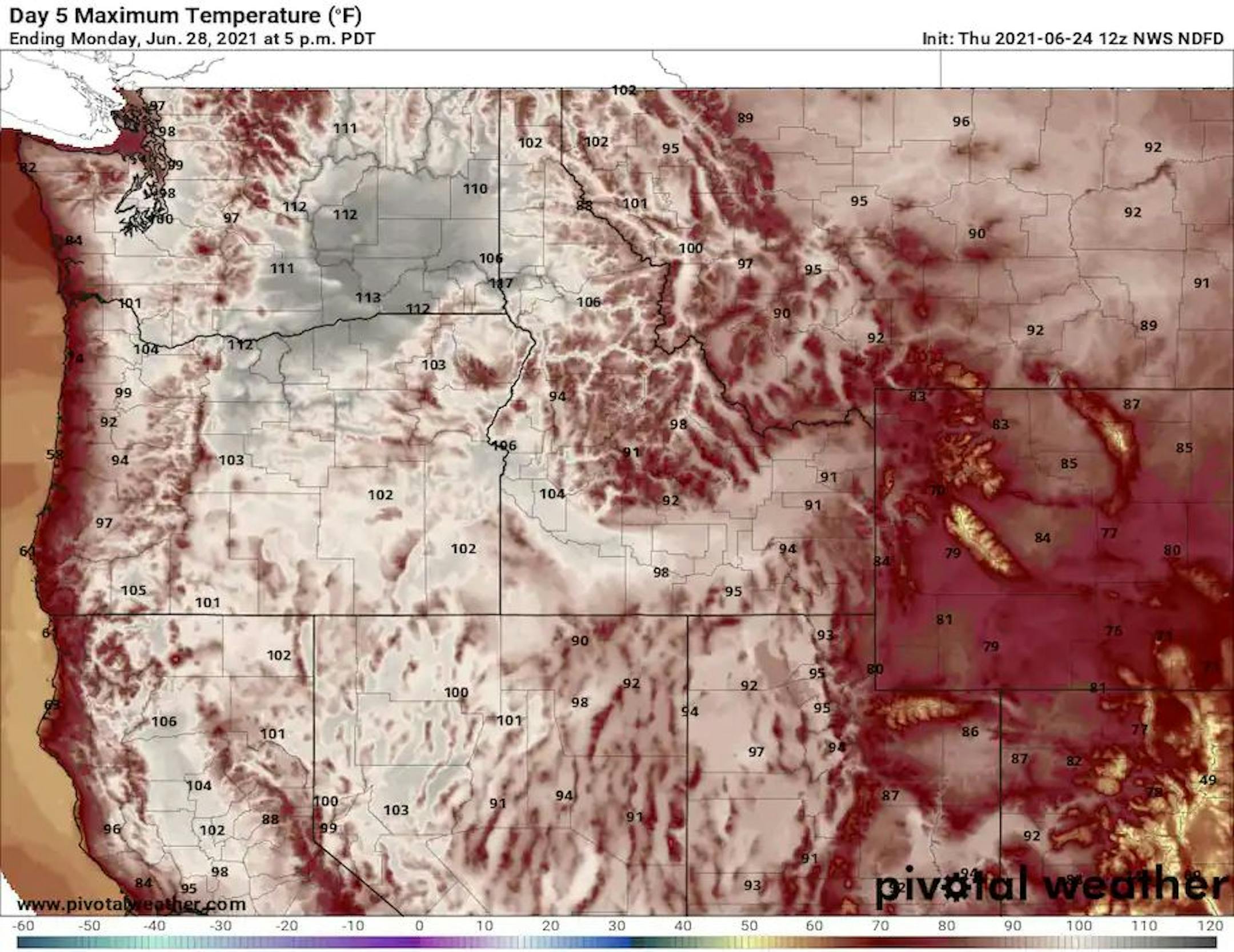
"Record high temperatures are forecast to be broken in Portland and Spokane, and approached in Seattle. Forecasts for a heat wave of historic proportions in the Pacific Northwest have solidified, and a consensus is building among meteorologists that this could rank among the most extreme events the region has ever seen. National Weather Service forecast offices in Portland, Ore., Seattle and Spokane, Wash., have all used the word "unprecedented" to describe the expected heat and are warning about its potentially lethal effects, considering significant portions of the population lack air conditioning. Numerous cities are predicted to approach or surpass their hottest weather ever recorded in June and probably any calendar month. Washington, Oregon and Idaho could challenge state highs, which are close to 120 degrees, according to the National Weather Service. With projected temperatures 15 to 30 degrees above average, the heat wave will be exceptional for its intensity. The duration, with triple digit afternoon highs and unusually warm nights lasting three to seven days, will also be brutal. Excessive heat watches and warnings affect over 13 million people, covering parts of northern California and western Idaho and much of Oregon and Washington, except for areas right along the coast. The excessive heat warning in effect for the area around Portland calls for "dangerously hot" temperatures Saturday through Monday. The temperature in Portland is predicted to reach 109 degrees on Sunday, which would break its all-time record of 107 degrees."

See more from the Washington Post HERE:

Weekend Heat Wave in the Northwest Unlike Any Other

  • A heat wave will impact areas of the Pacific Northwest this weekend.
  • There is potential that this heat wave may be historic. Some have a chance, to high chance of breaking all-time record highs. This heat can not be underestimated. It will be potentially life-threatening, especially to sensitive populations.

Excessive Heat Watches/Warnings/Advisories

Heat Advisories, Excessive Heat Watches, and Excessive Heat Warnings cover areas of Washington state, Oregon, California, Nevada, Idaho, Montana, and Canada.

What: Temperatures are already well above normal. Heat will continue to build to potentially dangerous to life threatening levels as high pressure builds. There is potential for all-time record high temperatures in some areas. So that means some may experience highs never before felt in the region. Those without adequate access to cooling or proper hydration will be at particularly high risk for heat-related illnesses like heat exhaustion or heat stroke.

When: Generally from Friday through Monday. In some areas, the heat wave may last as late as Thursday of next week.

Local Forecasts

Seattle: Excessive Heat Watch from 2:00 PM Friday to 9:00 PM PDT Monday. Dangerously hot conditions with afternoon highs in the 90s and near 100 possible Saturday through Monday.

Spokane: Excessive Heat Watch from 2:00 PM Friday to 7:00 PM PDT Wednesday. Dangerously hot conditions with afternoon highs near and over 100 degrees likely Saturday through Wednesday.

Portland: Excessive Heat Warning from 10:00 AM Saturday to 11:00 PM PDT Monday. Dangerously hot temperatures of 98 to 103 likely, with temperatures locally 103 to 108 are possible. Overnight low temperatures mostly 65 to 70 degrees

Boise: Excessive Heat Watch from noon Sunday to midnight MDT Thursday. Dangerously hot conditions with temperatures of 100 to 112 possible in the lower valleys and 90 to 100 in the mountain valleys.

Reno: Dangerously hot conditions with temperatures up to 105 possible for northeast California, the Sierra Front and Mineral County, and up to 108 degrees possible for the Western Nevada Basin and Range region including Fallon and Lovelock.

Day-By-Day Region Forecasts

Heat Safety. Remember to practice heat safety in these areas. Heat has been the leading cause of weather fatalities in the last 30 years. You can find more information on heat safety from NOAA: https://www.weather.gov/safety/heat

Praedictix Meteorologist Joe Hansel

Hot & Dry June So Far in the Twin Cities

Through the first 23 days of June, the Twin Cities is running nearly +8.5F above average, which is the warmest start to any June on record. We've also only had 1.10" of rain, which is the 15th driest start to any June on record.

Warmest & Driest June's On Record at MSP

Here are the top 20 warmest and driest June 1st - 23rd on record at the MSP Airport. Note that we are currently sitting at the warmest start to any June on record and also the 15th driest start to any June on record. The Driest June 1st - 23rd on record was back in 1910 when the Twin Cities only picked up 0.08" of rain.

Number of 90F Days in June

Through June 24th, MSP has seen 11, 90F days, which is the 5th most on record.

Weather Outlook Through Saturday Night

The weather outlook across the region through Saturday Night shows more unsettled weather pushing through the southern half of the state and especially along the MN and IA border. Some of the storms late Friday into Saturday could be a bit on the strong side near the IA border.

Extended Precipitation Outlook

Here's the extended precipitation outlook from NOAA's WPC through AM Monday, which shows the heaviest rains along the MN/IA/WI border, where several inches of rain can't be ruled out. Some of the heaviest will be found from a line near Kansas City, MO to Chicago, IL through the weekend ahead.

Friday Weather Outlook

The weather outlook for the Twin Cities on Friday shows temps warming into the upper 80s, which will be around +5F above average for the end of June. Dewpoints won't be terribly high, so it won't be too oppressive.

Minneapolis Meteograms

The meteograms for Minneapolis on Friday shows temps warming into the low 80s by midday. High temps will warm into the mid/upper 80s by late afternoon under partly cloudy skies. East to Northeasterly winds could gust close to 15mph through the day.

Regional Weather Outlook for Friday

The weather outlook across the region on Friday looks rather quiet across the region with temps running above average once again by nearly +5F. The best chance of showers and storms will generally be south of the Twin Cities and across parts of the Dakotas.

Extended Weather Outlook for Minneapolis

The extended weather outlook for Minneapolis shows temps warming into the 80s over the next several days. The warmest day will be on Friday with highs in the upper 80s, which will be nearly +5F above average. However, temps over the weekend and into early next week will only warm into the low/mid 80s, which will be closer to average for the end of June. Note that the first day of July is already next Thursday!

Weather Outlook Through AM Monday

Here's the extended weather outlook from Friday into AM Monday. Note that widespread showers and storms will be possible across the middle part of the country and into the Great Lakes Region. Some of the storms here could be strong to severe with locally heavy rainfall and flash flood potential.

8 to 14 Day Temperature Outlook

According to NOAA's Climate Prediction Center, the 8 to 14 day temperature outlook shows warmer than average temps continuing across much of the western US and part of the Midwest. However, cooler than average temps will settle in across the central and southern US.

Scorching Heat Wave Shifts to West Coast
By Paul Douglas

I've had plenty of duh-moments in my life, but a recent one in Seattle stands out. My oldest son and daughter in law were living in an apartment and it was hot (upper 80s). I marched down to the main desk and informed a friendly staffer that the A/C wasn't working. She looked at me with a mix of sadness and disgust, saying" This is Seattle. We simply don't need air conditioning. That's what the Pacific Ocean is for."

A stalled high pressure "heat dome" will prevent cooling winds from reaching the Pacific Northwest. Seattle and Portland may see a record-smashing 105F early next week (with no A/C in most homes).

A Canadian breeze keeps us in the 80s into next week with showers and T-storms Saturday PM into Tuesday. No scorching heat is expected here into next week, but some models bring a few 90s back into Minnesota after the 4th of July.

Moderate to severe drought is expanding across Minnesota and many are concerned. No "risk of storms" or "threat of rain". From now on it's an "opportunity for puddles".

Extended Forecast

FRIDAY: Sunny and comfortable. Winds: NE 8-13. High: 86.

FRIDAY NIGHT: More clouds, chance of t-storms overnight. Winds: ENE 5-10. Low: 68.

SATURDAY: Some AM sun, few PM T-storms. Winds: NE 8-13. High: 82.

SUNDAY: Unsettled, few pop-up T-storms. Winds: N 8-13. Wake-up: 67. High: 83.

MONDAY: Sunny start, instability PM storms. Winds: NE 5-10. Wake-up: 68. High: 83.

TUESDAY: Opportunity for showers, T-storms. Winds: NW 5-10. Wake-up: 69. High: 81.

WEDNESDAY: Partly sunny and warm. Winds: NW 7-12. Wake-up: 67. High: 84.

THURSDAY: Mix of clouds and sunshine. Winds: NE 8-13. Wake-up: 65. High: 82.

This Day in Weather History

June 25th

2003: Heavy rain falls across central Minnesota. Elk River picks up 8.19 inches. 4.36 inches fall in 4 hours in Maplewood, and there are reports of street flooding in St. Paul. Strong winds topple trees in Richfield.

1950: Flooding hits Warroad. Strong winds accompany waters that rose 4 feet in 10 minutes.

Average High/Low for Minneapolis

June 25th

Average High: 82F (Record: 98F set in 1934)

Average Low: 62F (Record: 46F set in 1957)

Record Rainfall: 2.88" set in 1978

Record Snowfall: 0.00"

Sunrise/Sunset Times for Minneapolis

June 25th

Sunrise: 5:27am

Sunset: 9:03pm

Hours of Daylight: ~15 hours & 36 minutes

Daylight LOST since yesterday: ~18 seconds

Daylight LOST since Summer Solstice (June 20th): ~1 Minute

Moon Phase for June 25th at Midnight

1.5 Days After Full "Strawberry" Moon

Thursday, June 25th at 1:40 p.m. CDT - Known to every Algonquin tribe. Europeans called it the Rose Moon.

See more from Space.com HERE:

What's in the Night Sky?

Moon, Jupiter, Saturn late night to dawn

On the last nights of June 2021, watch for three worlds in space: the moon, Jupiter, Saturn. The waning gibbous moon is past full on these nights. It's rising later in the evening or after midnight. On June 25, Saturn follows the moon into the sky by roughly an hour. Jupiter follows an hour or so after Saturn. But the moon is moving, always, toward the east in orbit around Earth. As a result, the moon rises an average 50 minutes later each night. So the moon catches up to Saturn and then Jupiter. On the night of June 26 (morning of June 27), the moon is near Saturn in the sky. By the night of June 27, the moon rises in between Jupiter and Saturn. And so it goes, as the evenings pass, with the moon shifting continually toward the east.

See more from Earth Sky HERE:

National High Temps Friday

The weather outlook on Friday shows cooler unsettled weather across the middle part of the country, where strong to severe storms and locally heavy rainfall will be possible. Some of the most extreme warmth for the end of June will set up in the Northwestern US and will intensify significantly as we head into the weekend and early next week.

National Weather Outlook

The national weather outlook through PM Saturday shows widespread showers and storms ongoing showers and storms across the Central US. Some of the storms could be strong to severe with locally heavy rainfall and flash flooding.

Extended Precipitation Outlook

According to NOAA's Weather Prediction Center the heaviest rainfall through the weekend and into next week will set up from the Texas Panhandle to the Great Lakes. Some of the heaviest tallies could approach 3" to 6" or more from near Kansas City, MO to Chicago, IL.

Climate Stories

"High stakes and high stress, forecasting tornadoes can take psychological toll"

"Tornadoes can have profound effects on meteorologists who issue warnings for them, especially when lives are lost. Chris Darden had just told his wife to take shelter from the tornado headed toward their home in Madison, Ala., when the phone call dropped. The violent storms bearing down on the state on April 27, 2011, were triggering widespread power outages, causing cellular networks to go dark. Unable to reach his wife again, Darden did the only thing he could do: He went back to his desk at the National Weather Service office in Huntsville, where he had just assumed the role of meteorologist in charge. As damage reports started to roll in from his neighborhood, Darden issued warning follow-ups, coordinated with emergency managers, and tried not to worry too much about his wife and daughter. It wasn't easy. "When the phone goes dead and you start hearing reports of damage from your neighborhood, immediately the worst goes through your mind," said Darden, now the meteorologist in charge at the Birmingham Weather Service office. "You can't divest yourself from the reality of what's going on around you."

See more from The Washington Post HERE:

"Travel to Florida is surging this summer, but so are storm-related delays"

"Travelers are flocking to the Sunshine State just when the weather is most turbulent and unpredictable. In April 2020, at the height of the coronavirus pandemic, the number of daily flights overseen by the Federal Aviation Administration dipped below 11,000. Now, with coronavirus vaccination rates trending upward and case numbers relatively low, Americans are ready to travel again. The FAA is managing 40,000 flights a day at this point and expects to handle as many as 48,000 flights daily by the end of the summer. "We're already seeing traffic is back," said Daniel Murphy, director of National Airspace System Operations at the FAA. "If you have money, you want to go on vacation. You're going to places in the United States like Florida." For the past year, meager air traffic has meant minimal delays, even in the face of inclement weather. With so few flights, planes waylaid by storms weren't likely to end up in a holding pattern at their destination waiting for an open runway. The recent surge in air traffic, however, has led to more delays, particularly in Florida. Meteorologist photographs stunning cloudburst over Florida from plane Murphy said the number of flights to Florida is actually 10 percent higher than it was at this time in 2019, before the pandemic, posing an unusual challenge for air traffic controllers."

See more from the Washington Post HERE:

"A Structure In Deep Space Is So Giant It's Challenging Standard Physics"

"Scientists have discovered a structure in the distant universe so immense that it is actually challenging our understanding of the universe. Known as the Giant Arc, this crescent-shaped stream of galaxies stretches across 3.3 billion light years, making it about one-fifteenth the radius of the entire observable universe. The unusual discovery was recently announced by Alexia Lopez, a PhD student at the University of Central Lancashire who detected the Giant Arc, at the 238th virtual meeting of the American Astronomical Society. "It's so big that it's hard to explain with our current theories," Lopez said during her presentation on June 7. Lopez first spotted the structure, which is located 9.2 billion light years from Earth in the constellation Bootes, in observations captured by the Sloan Digital Sky Survey, based in New Mexico. At the time, she was researching a technique called the magnesium II (MgII) method that probes the spectral fingerprints of ionized magnesium in space to detect structures that might otherwise remain hidden. "The Giant Arc was a serendipitous discovery," Lopez said in an email. "I was working on understanding the MgII method and how well it worked, when this one particular piece of sky I was testing happened to show the first hints towards something exciting. That's when I started to look more into this bit of sky and slowly, but surely, the Giant Arc was revealed."

See more from Vice HERE:

Thanks for checking in and don't forget to follow me on Twitter @TNelsonWX