A Busy Sunday In Mid April...
"Rain will transition to snow across the area late tonight and Sunday, with accumulating snow expected for many areas, particularly from central Minnesota into west central Wisconsin. Winds will increase on Sunday with gusts above 40 mph Sunday afternoon into Sunday evening for much of the area."

Snowfall Potential
Sunday will feature wet slushy snowfall accumulations, which could add up in a few communities. Note that ground temperatures are very warm, so snowfall accumulations will be determined by how hard the snow falls in your area during the day. Whatever falls will be short-lived.

3rd Snowiest Winter on Record
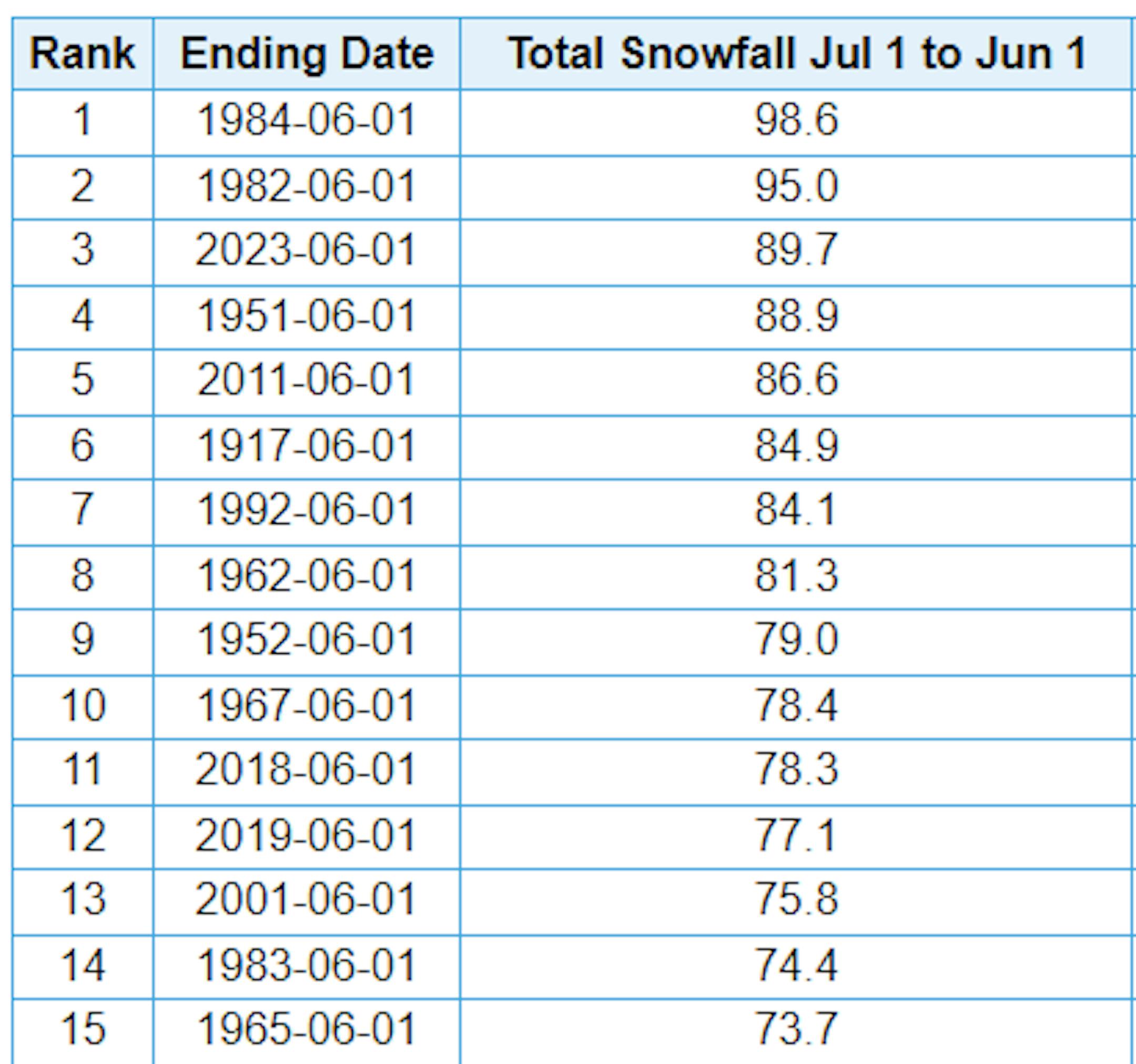
Just a reminder that MSP has seen nearly 90" of snow this season, which is the 3rd snowiest winter season on record. We need 5.4" more get into the 2nd spot and 9" to get into the top spot. If you're wondering, the latest measurable snow (0.1") on record at MSP was on May 24th set in 1925. The snow season isn't quite over just yet... Stay tuned.
Thunder Blizzard: April 13-16, 2018
"An extreme, late-season winter storm struck Minnesota from April 13-16, 2018, producing everything from thunderstorm wind damage to prolonged blizzard and whiteout conditions. The storm came in three distinct rounds, each separated by anywhere between four and eight hours. When all was said and done, an unusually large area of Minnesota, covering about 20 percent of the state, had over a foot of snow. Roughly half of the state had six inches or more, and numerous NWS cooperative observers reported three-day totals in excess of 15 inches. The largest "official" reports included 26.5 inches at Canby in Yellow Medicine County, 21.4 inches at Madison, 19.6 inches at Lake Wilson, and 19.5 inches at Milan. Numerous observers with the CoCoRaHS network similarly recorded amounts between 19 and 21 inches. The blizzard made travel nearly impossible. It grounded flights at Minneapolis-St. Paul International Airport for over seven hours and caused over 600 accidents, nearly 1200 spin-outs, and approximately 20 jackknifed semi trailers. The storm also collapsed the 77-foot-high dome of the Vadnais Sports Center, and forced three consecutive Minnesota Twins home games to be postponed for the first time since Target Field opened. In the Twin Cities, the snowfall total of 15.8 inches was the largest to occur so late in the season, broke the storm-total accumulation record for April, and made April of 2018 the snowiest April on record. Additionally, by holding temperatures to the 20s or very low 30s during Saturday and Sunday, the storm enabled St. Cloud, Duluth, Rochester, and the Twin Cities to break records for the lowest high temperature of the day."

Snow Depth
As of Saturday, April 15th, lots of snow had vanished across the region compared to what we had at the beginning of the month. In fact, the landscape looks dramatically different over the last 2 weeks.

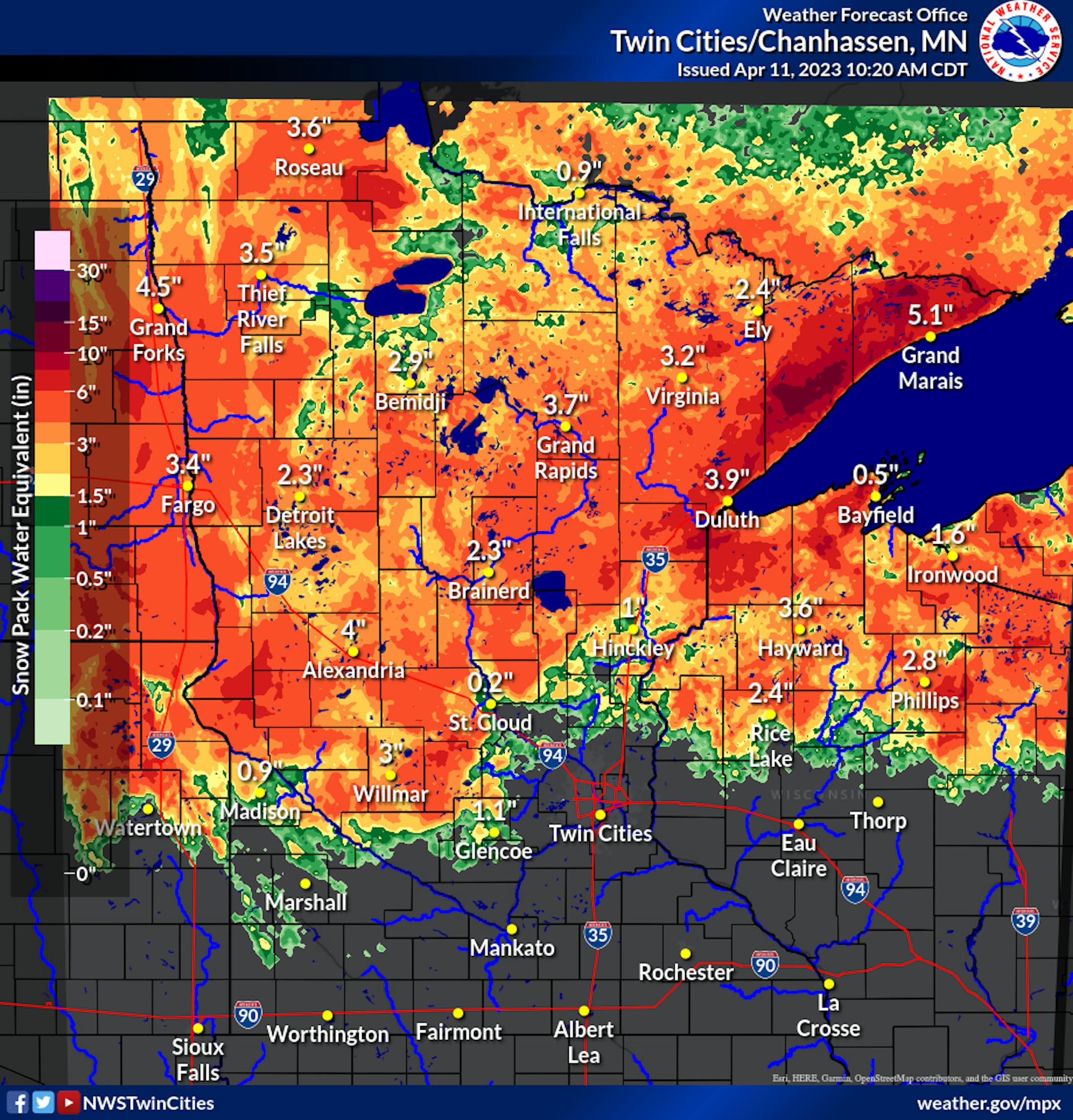
Snow Pack Water Equivalent
According to the National Weather Service, a significant amount of snow has melted across the region over the last few days, which means that a significant amount of water has entered rivers, streams and creeks this week. Take a look at the difference in SWE from April 11th to the 14th. Some of the most significant changes took place across the norther half of the state, where some locations are now seeing no snow on the ground!
SWE on April 11th