

Snow Departure Has Stayed Above Average This Snow Season
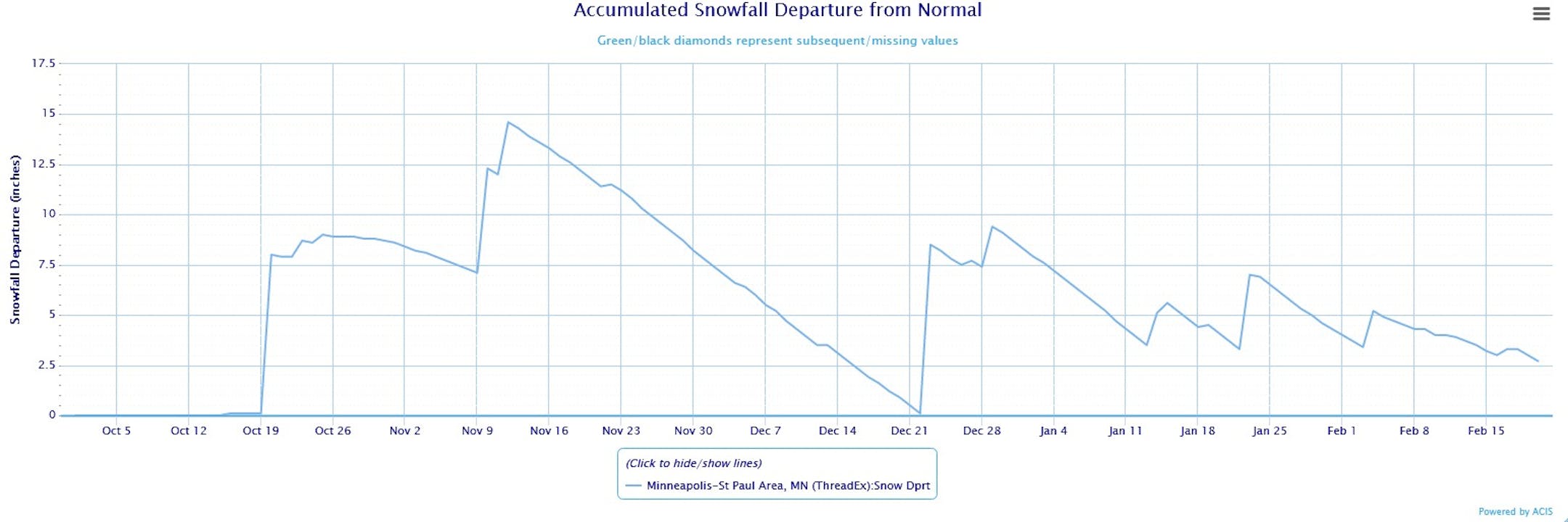
While 66% of our snowfall this season (through Saturday) has fallen on only four days, that snow - especially what fell very early on in the season - has helped keep the departure from average above average all season in the Twin Cities. The closest we got to dipping below average was back on December 22 when the departure was only 0.1" above average. We saw the pre-Christmas blizzard hit the next day, helping to pop our values back upward. The day that has had the greatest departure from average so far this snow season was back on November 12, when we were 14.6" above the average-to-date snowfall for the season. As of Saturday we sat at 2.7" above average for the season, however that should increase with the snow we saw Sunday.
_______________________________________________
Still A Cold February So Far

While our average temperature so far in February has started to creep upward since we have climbed out of the subzero range for highs, we are still almost 16F degrees below average for the month-to-date through Saturday. Due to that, it's still the 7th coldest start to February on record. With several days this week expected to see above average highs, that average temperature should start to climb a little faster. However, I do expect this February should be at least finish off in the coldest half of Februarys on record.
_______________________________________________
Quiet Monday - Highs Finally Returning To The 40s
By D.J. Kayser, filling in for Paul Douglas
I must say, it felt nice to be able to get outside this past weekend and not have the temperatures make me immediately regret the decision!
Through Saturday we have picked up 42.0" of snow so far this snow season at MSP airport. About 66% of that snow has fallen on four separate days: October 20, November 10, December 23, and January 23. However, that has helped keep the departure from average for snowfall above average all season. The closest we got to dipping below average so far? +0.1" back on December 22, right before the pre-Christmas blizzard.
We could see our first two-day stretch of 40F degree weather since the pre-Christmas blizzard as we begin the work week. This will lead to some melting snow across the region. Highs will drop back into the 20s and 30s for the second half of the week, but I don't think we'll be complaining!


