More Snow Through Wednesday Afternoon

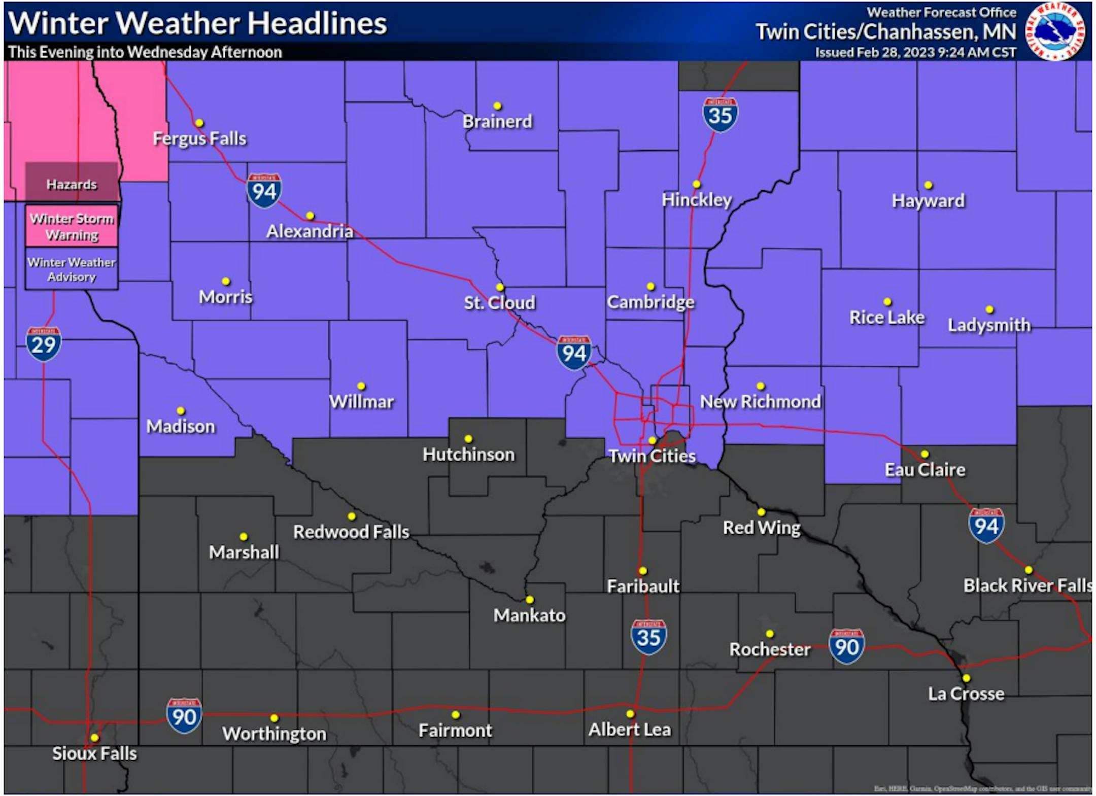
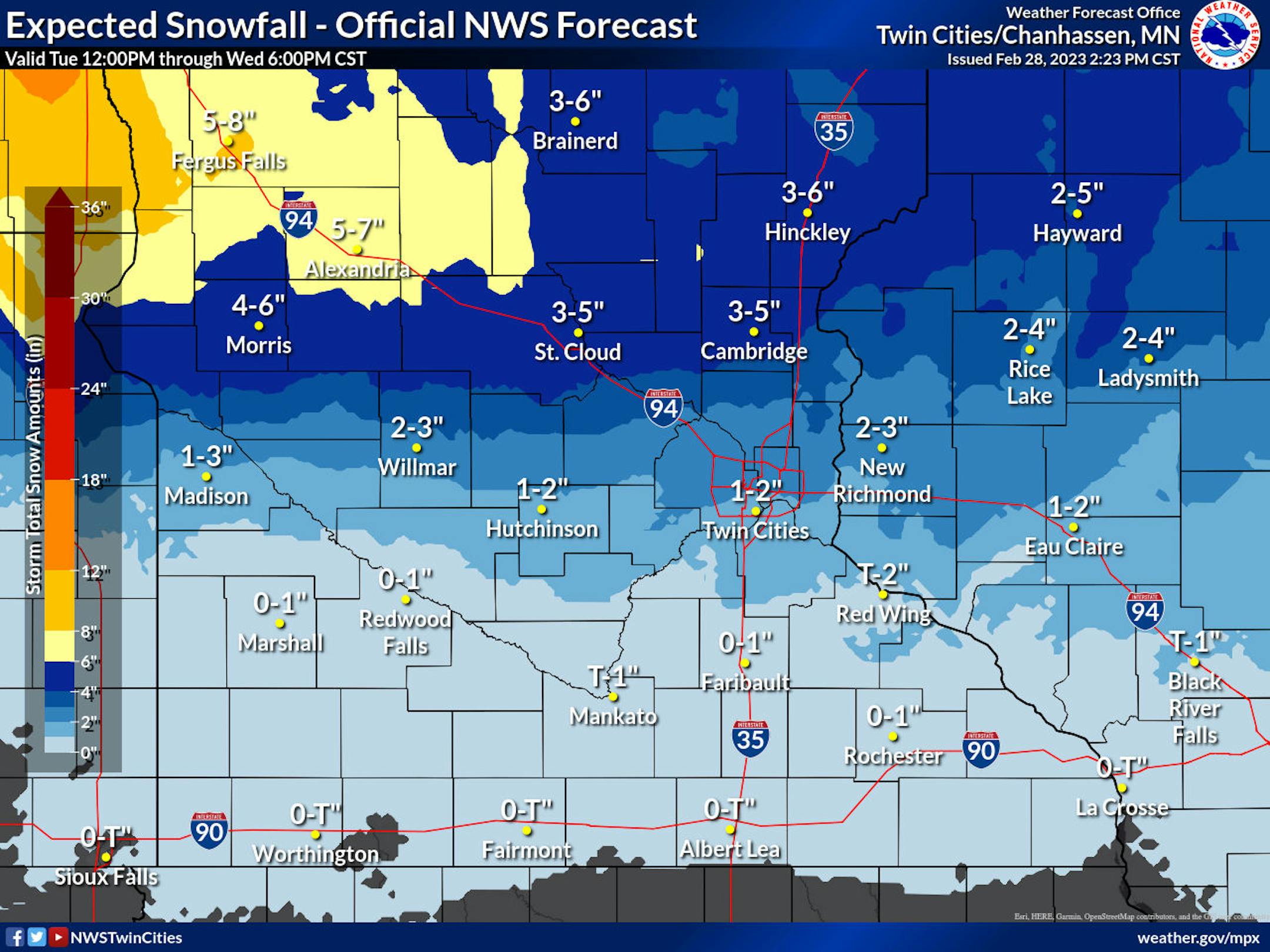
Light snow will develop over southwestern Minnesota Tuesday evening and spread eastward over central and eastern Minnesota through western Wisconsin Tuesday night into Wednesday, ending Wednesday afternoon. Most locations within this band of snow will see 3 to 6 inches, with locally higher amounts possible. Areas most likely to receive in excess of 3 inches of snow include those along and north of a line from Montevideo to the Twin Cities MN to Eau Claire WI. A Winter Weather Advisory has been issued for those portions of central MN through western WI.

WINTER WEATHER ADVISORY IN EFFECT FROM 9 PM THIS EVENING TO 3 PM CST WEDNESDAY

WHAT...Snow expected. Total snow accumulations of 3 to 5 inches.

WHERE...Portions of central and east central Minnesota.

WHEN...From 9 PM this evening to 3 PM CST Wednesday.

IMPACTS...Plan on slippery road conditions. The hazardous conditions could impact the Wednesday morning commute.
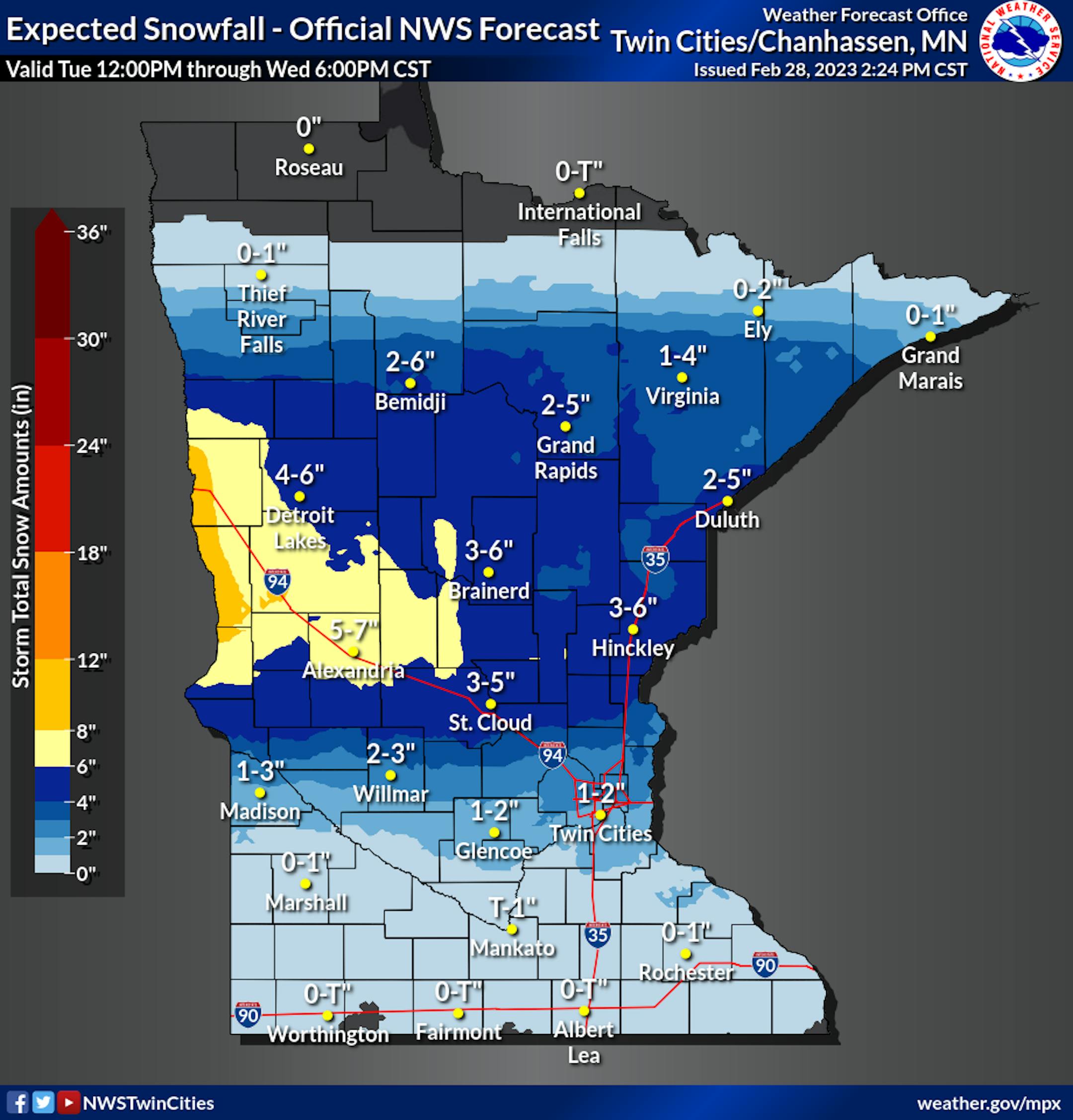
Snowfall Potential

The Twin Cities may only see an inch or two of snow out of this next system with some 3" to 5" across parts of Central Minnesota. Heavier amounts of 4" to 8" will be possible north and west of Alexandria. Gusty winds will be responsible for blowing snow and significantly reduced visibilities near the Red River Valley.

Slow Commute Wednesday

Not great timing, but snow is expected through the early part of Wednesday, which will make for a slow morning commute from the Twin Cities and places north. "Ice & Snow, Take It Slow"

NWS Twin Cities 2023 Spring Flood Outlook

Big Changes in just two weeks... The late February updated outlook for spring flooding in the upper Mississippi, Minnesota, and Chippewa River basins has been upgraded to above normal. The addition of another 1-2 inches of water into the snowpack (from rain, then heavy snow) has increased the threat in just two weeks. Though we have an ample snowpack, drier soils and little frost depth will help alleviate at least some of the snowmelt threat. The threat of seeing major flooding will still depend on what kind of rainfall/temperature patterns we get during the snowmelt. Spring Flood Factors. We'll examine the main ingredients we need to combine to see spring flooding in our area... Snowpack How much snow is on the ground right now, and more importantly, how much water is in that snow? Let's take a look...

See more from the NWS HERE:

Extended Temperature Outlook

The NBM extended temperature outlook for Minneapolis over the next several days shows milder temperatures in place with highs in the 30s and possibly the 40s as we head into the first few days of March.

Snow Depth

As of Monday, February 27th, the MSP Airport had 11" of snow on the ground. Much of the state of Minnesota and into northern Wisconsin has a pretty significant snowpack. Nearly 2ft of snow is on the ground near Lake Superior and almost 3ft on the ground near Marquette, MI.

Seasonal Snowfall

After last weeks storm system, many locations are now nearly 2ft to 3ft above average snowfall for the season from Sioux Falls to the Twin Cities and north toward Duluth. 71.0" of snow has fallen at the MSP Airport so far this season (since July 1st), which is the 6th snowiest start to any season on record and nearly 30" above average. Duluth has seen nearly 93" of snow this season.

Twin Cities Weather Outlook For Wednesday

The weather outlook for the Twin Cities on Wednesday, March 1st will be a little snowy with a minor accumulation possible across the Twin Cities metro. Amounts will be heavier farther north with stronger winds.

Weather Outlook on Wednesday

Temps across the region on Wednesday will be close to average across the southern half of the state and will be cooler than average farther north. Areas of accumulating snow will wrap up around midday and into the early afternoon.

Meteograms For Minneapolis

The weather outlook for the Twin Cities through the day Wednesday shows fairly steady temperatures in the low/mid 30s with cloudy skies and areas of snow. North to northeasterly winds will be breezy at times, which could cause some blowing snow across parts of central Minnesota, where temperatures will be a little colder.

Hourly Feels Like Temps

Feels like temps on Wednesday will hover in the 20s through much of the day with gusty north to northeasterly winds.

Weather Outlook

Weather conditions will be very active in the Central US this week as a series of storms moves in from the West Coast. The first weaker system will impact the Upper Midwest late Tuesday into Wednesday, but a much larger storm system will develop in the Southern US later this week with widespread showers and thunderstorms, some of which could be strong to severe with locally heavy rainfall. On the northern edge of this will be heavier snowfall potential across parts of the Midwest and into the Great Lakes.

Severe Weather Concerns Wednesday & Thursday

According to NOAA's SPC, there is a risk of strong to severe thunderstorms with large hail, damaging winds and even tornadoes. Areas of heavy rainfall will be possible as possible.

Extended Temperature Outlook For Minneapolis

Temps over the next several days will warm into the 30s. The coolest day will be Thursday, but we should warm to near 40F on Sunday.

Extended Weather Outlook For Minneapolis

Weather conditions will be a little active midweek with areas of minor snow accumulations on Wednesday. We'll be a little cooler Thursday and Friday, but will warm to near 40F late weekend and early next week.

8 to 14 Day Temperature Outlook

According to NOAA's Climate Prediction Center, the 8 to 14 day temperature outlook shows cooler than average temperatures across much of the nation and especially from the Midwest to the Northwest.

8 to 14 Day Precipitation Outlook

According to NOAA's Climate Prediction Center, the 8 to 14 Day precipitation outlook shows more active weather in place across much the nation and especially in the Western US.

Prepare For A Meteorologically Manic March
Paul Douglas

Welcome to Meteorological Spring. In theory, on paper, the 90 coldest days of the year (on average) are behind us now. In the coming weeks we'll probably see as many rainstorms as snowstorms. The average date of the last inch of snow on the ground is March 31.

Back in the 80s March was the snowiest month of the year. Now, based on 1991-2020 data, March is the 4th snowiest month, with an average of 8.2". Unlike January, March snows are wet and sloppy and usually melt within a few days. Usually.

Exhibit A: today's storm system may drop 1-3" on the Twin Cities metro, with more snow the farther north you go - maybe a stripe of 3-5" from Alexandria to St. Cloud and Taylors Falls. Skies clear Thursday with warming temperatures near 40F by Saturday.

Friday's storm will drop plowable snow on southern Wisconsin, passing tour south/east. A few inches of snow may fall here Sunday night into Monday. Next week at this time some metro locations may be close to 80" of snow this winter. A real winter for snow lovers!

Extended Forecast

WEDNESDAY: 1-3" snow. More north. Winds: NE 10-20. High: 34.

WEDNESDAY NIGHT: Mostly cloudy. Winds: N 10-15. Low: 18.

THURSDAY: Peeks of sunshine. Winds: SE 5-10. High: 30.

FRIDAY: Partly sunny, storm stays south. Winds: N 7-12. Wake-up: 19. High: 36.

SATURDAY: Mix of clouds and sunshine. Winds: NW 10-20. Wake-up: 20. High: 38.

SUNDAY: Clouds increase, nighttime snow?. Winds: SE 10-20. Wake-up: 20. High: 36.

MONDAY: Mostly cloudy, cool wind. Winds: NW 15-25. Wake-up: 29. High: 39.

TUESDAY: Some sun. Snow tonight. Winds: S 5-10. High: 36.

This Day in Weather History

March 1st

1966: The Blizzard of '66 hits Minnesota and lasts 4 days. Aitkin received 23 inches of snow. The snow depth at International Falls reached a record 37 inches by the end of the storm.

Average High/Low for Minneapolis

March 1st

Average High: 34F (Record: 59F set in 1990)

Average Low: 18F (Record: -26F set in 1962)

Record Rainfall: 0.70" set in 2012

Record Snowfall: 8.0" set in 1907

Sunrise/Sunset Times for Minneapolis

February 28th

Sunrise: 6:50am

Sunset: 6:00pm

Hours of Daylight: ~11 hours & 09 minutes

Daylight GAINED since yesterday: +3 Minutes & 5 Seconds

Daylight GAINED since Winter Solstice (December 21st): ~ 2 hour & 23 minutes

Moon Phase for March 1st at Midnight

3.0 Day Since First Moon

National High Temps on Wednesday

Temperatures on Wednesday will be very mild across the eastern half of the nation and especially across the Southern and Southeastern US, where record warmth will be possible. Meanwhile, the Western US will be cooler than average by nearly -10F to -15F.

Record Warmth Wednesday

There will be record warmth in a few spots across the Southern US, where temps will be nearly +15F to +20F above average.

National Weather Outlook Wednesday

The weather outlook for Wednesday shows Widespread precipitation across the Eastern US. Showers and thunderstorms will be possible from the Mid-Atlantic to the Lower Mississippi Valley with areas of wintry precipitation farther north. Meanwhile, areas of rain and snow will be possible in the Southwestern US.

National Weather Outlook

A large storm will develop in the Western US with areas of heavy rain and snow. This storm will move into the Central US with widespread showers and thunderstorms, some of which will be strong to severe with locally heavy rain. On the western & northern side of the storm, there will be areas of heavy snow.

Extended Precipitation Outlook

According to NOAA's Weather Prediction Center, the extended precipitation outlook shows heavier amounts from the Central US to the Ohio Valley and into the Northeast. Meanwhile, heavy precipitation will be found in the Western US and especially in the high elevations.

Snowfall Potential

According to the ECMWF (European model), heavy snow will be found across much of the high elevations in the Western US. Parts of the Midwest and Great Lakes and into the Northeast will see heavy snow as well.

Climate Stories

"Hold onto your satellites: The sun is about to get a lot stormier"

"On Friday, February 17, a part of the sun erupted. A piercingly bright flash of light—a solar flare—shone briefly from the left limb of our star, where it was captured in an ultraviolet image by NASA's Solar Dynamics Observatory spacecraft. "It wasn't the largest in history by any means, but it was a significant X flare," Thomas Berger, a solar physicist and director of the Space Weather Technology, Research, and Education Center at the University of Colorado Boulder. (The "X" refers to the letter grading system of solar flare intensity, which ranges from minor A-class to severe X-class flares. "Solar flares of that magnitude will generally cause some radio-interference on the sunlit side of the Earth for an hour or two," he says. Ultimately, this one was fairly mild—the most powerful solar flare ever recorded, in 2003, was more than 100 times more powerful by comparison—and did not cause any major problems."

See more from Popular Science HERE:

"Cold Weather Dogs: These are the 10 breeds of adorable dog that cope best with cold climates - including the loving German Shepherd"

"If you live in a freezing cold country, or your idea of fun is a long winter walk through ice and snow, these are the breeds of dog that will be happy to join you. A huge number of us decided to welcome new pups into our homes in the last couple of years – according to Kennel Club figures dog ownership soared and post-lockdown demand for four-legged friends remains high. There are a whopping 221 different breeds of pedigree dog to choose from, alongside numerous crossbreeds, so there's plenty of thinking to do before you select your family's latest addition. There's even academic guidance to seek out, with Psychologist Stanley Coren's book 'The Intelligence of Dogs' ranking breeds by instincts, obedience, and the ability to adapt. One thing to take into consideration is that some dogs have been bred specifically to cope with – or even enjoy – living in a cold climate. These hardy breeds will think nothing of long walks in snow and sub-zero temperatures, so if you have an ourdoorsy lifestyle they are the pups that should feature high up on your canine wish list. Here are the 10 breeds of dog that thrive in cold conditions."

See more from The Scotsman HERE:

"The World May Be on the Verge of Very Significant Warming"

"La Niña typically casts a bit of a chill over the globe, and that certainly has been the case during its reign over the past three years. Yet despite the climate phenomenon's continuing influence, last month turned out to be one of the warmest Januarys ever recorded globally. Moreover, even though La Niña exerted its maximum cooling effect in 2022, that year still entered the record books as being warmer than 2021. The reason, of course, was human-caused climate change. Now, La Niña is fading away, and El Niño — which usually warms the climate — stands a 60 percent chance of emerging in the fall. So the globe could be on the verge of some very significant warming."

See more from Discover Magazine HERE:

Thanks for checking in and don't forget to follow me on Twitter @TNelsonWX