Somewhat Soggy Weekend Ahead

A slow-moving storm system will be responsible for shower and thunderstorm chances as we head into our first weekend of Fall. The first round of showers moves in PM Friday with the heaviest and best chance of thunderstorms late Saturday into Sunday. Some of the storms could be a little on the strong and possibly severe side with locally heavy rainfall.

Simulated Radar

Here's the simulated radar from AM Friday to Saturday night. The center of circulation will be situated over the Dakotas and will be the feature responsible for the widespread showers and storms across much of the region. Multiple waves of rain will be possible over the next few days and some spots could see 1" to 2" of rain or more through Sunday. Note that some of the storms could be strong to severe as well.

Severe Threat on Friday

According to NOAA's Storm Prediction Center, there is a Marginal Risk of severe thunderstorms across the southwestern part of Minnesota. The main concern will be hail along with pockets of heavy rain.

Severe Threat Saturday

According to NOAA's Storm Prediction Center, there is a Marginal Risk of severe weather across the southern half of the state, including the Twin Cities. The far southwest corner of the state is under a Slight Risk, which is a level 2 out of 5 on the severe scale. Within both of these severe risk areas, large hail and damaging winds will be possible along with locally heavy rainfall.

Rainfall Potential Through The Weekend

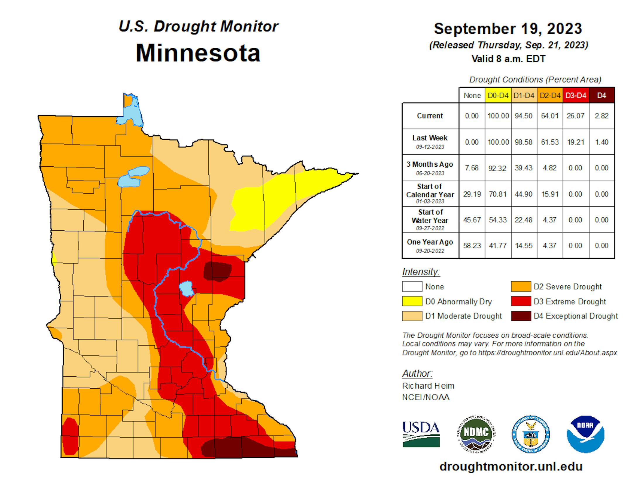
According to NOAA's Weather Prediction Center, there could be some 1" to 2" rainfall tallies across parts of Western and Southwestern Minnesota. Much of the state is well below average precipitation, so it would be nice to get a good soaking.

Fall Color Update

Here's a picture from the Lutsen Mountain webcam from earlier Thursday. Lots of color showing up from sugar maples along the North Shore. Peak color isn't far away - book those fall peeping plans now!

See more from Lutsen Mountain HERE:

Fall Color Update

According to the MN DNR, the fall color season is underway and happening fast. Parts of western and northwestern Minnesota are halfway through the season with peak not far behind. Fall colors will continue to rapidly change, so take a moment and enjoy the season while you can. Note that most leaves will vacate the premises in about 1 month and won't return until sometime in mid/late May...

Typical Peak Fall Color

According to the MN DNR, typical peak color arrives across the international border mid to late September with peak color arriving near the Twin Cities late September to mid October. It won't be long now and you'll be able to find your favorite fall color in a backyard near you.

Developing Ophelia

According to NOAA's NHC - the next tropical wave will develop into Ophelia and make landfall along the North Carolina Coast early Saturday. Tropical Storm Warnings have been posted from the North Carolina Coast to the Delmarva Peninsula.

Atlantic Outlook

According to NOAA's NHC, the Atlantic basin is still quite active. Nigel continue to the far north, but we have 2 other systems developing, one of which is close to the East Coast.

Past Peak of the Atlantic Hurricane Season

The Atlantic hurricane season runs from June 1st to November 30th, but did you know that the typical peak is September 10th? This is when the Atlantic Basin has had the most hurricanes and named storms since records began. This is also when weather conditions are at optimal levels for these types of storms.

90 Day Precipitation Anomaly

On average, the wettest time of the year is in the summer, with the months of June, July and August seeing nearly 13" of rain at the MSP Airport. If we take a look at the 90 day precipitation anomaly, which dates back to early to mid June, some locations are nearly -3.00" to nearly -7.00" below average (in red/pink). Note that some locations across southeastern Minnesota are nearly -8.00" to -10.00" below average.

Drought Update

Drought continues and expanded across the State. We now have a more expanded Extreme Drought from parts of central Minnesota to southeastern Minnesota. Much of the Twin Cities Metro is now in the Extreme drought as well. Note that nearly 97% of the state is considered to be in drought conditions.

Weather Outlook For Friday

The weather outlook on Friday shows temps warming into the 70s across much of the state, which will be nearly +5F to +10F above average for mid-September. There will be an increase in shower and thunderstorm development across the region through the day.

Twin Cities Weather Outlook For Friday

The weather outlook for the Twin Cities on Friday, September 22nd will turn a little more unsettled as we head through the day. The day will start dry, but there could be a few stray showers and storms late in the afternoon and evening.

Meteograms For Minneapolis

Weather conditions for Minneapolis on Friday will turn more unsettled late in day with increasing shower and storm chances. Temps will start around 60F in the morning and will top out in the mid 70s in the afternoon with a breezy southeasterly wind around 15mph to 20mph.

Extended Temperature Outlook For Minneapolis

The 5 day temperature outlook for Minneapolis shows slightly above temperatures through Saturday with highs warming in the 70s. It'll get cooler late weekend and into early next week with highs hovering around 70F.

Somewhat Humid Weekend, Then Cooling

The max dewpoint forecast for Minneapolis looks a little humid with increased rain chances over the weekend. As this next long duration storm system moves out, dewpoint readings will fall into the more comfortable 50s.

Extended Weather Outlook For Minneapolis

The 7 day extended weather outlook shows more unsettled weather in place through the weekend with rounds of showers and storms. Temps will fall to around 70F, which is pretty close to normal for this time of the year.

A Slight Temperature Bump Next Week

According to NOAA's National Blend of Models, temperatures will warm to above average levels through Saturday. Highs will then settle back into the lower 70s through the last full week of September, which is closer to average for this time of the year.

Weather Outlook

The weather outlook in the Midwest through next weekend will become more unsettled, especially late week and into the weekend as a slow-moving storm system blows into town. The weekend will trend wetter and cooler as the storm system drifts overhead.

8 to 14 Day Temperature Outlook

According to NOAA's Climate Prediction Center, the 8 to 14 day temperature outlook shows Warmer than average temperatures across much of the eastern two-thirds of the nation. Meanwhile, the western US will be cooler than average.

8 to 14 Day Precipitation Outlook

According to NOAA's Climate Prediction Center, more active weather will develop across parts of the Western US and could possibly spill into parts of the Midwest. Meanwhile, it'll be drier east of the Mississippi River.

Partly Smokey With Weekend Showers
By Paul Douglas

I can't seem to get the chorus from Sanford Townsend Band's "Smoke From a Distant Fire" out of my head. Brain cobwebs. At least report 5% of Canada's forests have burned this summer. That's an area roughly the size of Florida.

Much of that smoke has drifted over Minnesota, in fact MPCA has issued a record 20 Air Quality Alerts covering 52 days, eclipsing the old record of 13 alerts covering 42 days in 2021. That's why it's been so hazy and murky out thereat times.

Maybe a weekend "storm" will clean things up, if only temporarily. You remember storms right? We salvage some mild sunshine today before showers and T-storms push across the state Saturday, with heaviest rains staying west of the MSP metro until the nighttime hours.

Weather models are as reliable as fantasy football outlooks, but heaviest rains (over 2") may fall near Willmar and Windom. A half inch for the Twin Cities? Most of the metro is back in extreme drought. We will savor every drop.

I think we'll see more 80s in early October. Crazy.

Extended Forecast

FRIDAY: Sunny peeks, stiff breeze. Winds: SE 10-20. High 78.

FRIDAY NIGHT: Mostly Cloudy. Chance of t-showers. Winds: ESE 10. Low: 63.

SATURDAY: Showers, T-storms, heavy west of MSP. Winds: SE 15-30. High: 80.

SUNDAY: Showers taper, skies may brighten PM. Winds: SE 15-35. Wake-up: 61. High: 71.

MONDAY: Clouds linger, few spotty showers. Winds: SE 10-20. Wake-up: 60. High: 72.

TUESDAY: More clouds than sun. Winds: SE 10-15. Wake-up: 57. High: 73.

WEDNESDAY: More sun, hints of fall. Winds: SE 10-15. Wake-up: 55. High 74.

THURSDAY: Spurts of lukewarm sunshine. Winds: SE 10-20. Wake-up: 54. High 76.

This Day in Weather History

September 22nd

1996: A brief cold air funnel touchdown results in roof damage in Washington County.

1936: Summer-like heat continues with 101 at Ada, Beardsley and Moorhead.

Average High/Low for Minneapolis

September 22nd

Average High: 71F (Record: 95F set in 1936)

Average Low: 52F (Record: 26F set in 1974)

Record Rainfall: 2.80" set in 1895

Record Snowfall: NONE

Sunrise/Sunset Times for Minneapolis

September 202nd

Sunrise: 7:00am

Sunset: 7:11pm

Hours of Daylight: ~12 hours & 11 minutes

Daylight LOST since yesterday: 3 Minutes & 6 Seconds

Daylight LOST since Summer Solstice (June 21st): ~ 3 Hour & 26 Minutes

Moon Phase for September 22nd at Midnight

0.5 Days Before First Quarter Moon

National High Temps on Friday

Temperatures on Friday will be fairly mild across the middle part of the country with temps warming into the 80s and 90s, which will be above average for this time of the year. Folks along the East Coast will be cooler than average as developing Ophelia moves in.

National Weather Friday

The weather outlook on Friday shows more unsettled weather across the Central US with widely scattered storms developing, some of which will be strong to severe with locally heavy rainfall.

National Weather Outlook

The weather outlook through Sunday turns more unsettled across the Central US with widely scattered showers and storms. Some of the storms could be strong to sever with locally heavy rainfall.

Extended Precipitation Outlook

The extended precipitation outlook shows areas of heavy rainfall across the East Coast as an area of low pressure develops and slides north. We'll also see some heavier precipitation potential in the coastal areas of the Pacific Northwest and across the Central US as we head into the weekend ahead.

Climate Stories

"Twitter Ranked Dead Last on Climate Misinformation Scorecard"

"In a new assessment of several major social media platforms, X, formerly known as Twitter, came in dead last in managing climate misinformation. A report released on Wednesday by Climate Action Against Disinformation (CAAD), a coalition of more than 50 environmental groups, scored several social media platforms. The company with the most points ranked the highest in fighting climate misinformation. The platforms could receive up to 21 points from a combination of categories including transparency, advertising, policy content, and enforcing their rules on climate misinformation. X only received a single point for "lacking clear policies that address climate misinformation, having no substantive public transparency mechanisms, and offering no evidence of effective policy enforcement," the report said. All other platforms ranked higher. YouTube came in second to last with 6 points. Meta and Instagram tied at 8 points, TikTok received 9 points. Pinterest came out on top with 12 points."

See more from Gizmodo HERE:

"As extreme downpours trigger flooding around the world, scientists take a closer look at global warming's role"

"Torrential downpours sent muddy water racing through streets in Libya, Greece, Spain and Hong Kong in early September 2023, with thousands of deaths in the city of Derna, Libya. Zagora, Greece, saw a record 30 inches of rain, the equivalent of a year and a half of rain falling in 24 hours. A few weeks earlier, monsoon rains triggered deadly landslides and flooding in the Himalayas that killed dozens of people in India. After severe flooding on almost every continent this year, including mudslides and flooding in California in early 2023 and devastating floods in New York and Vermont in July, it can seem like extreme rainfall is becoming more common. So, what role does global warming play in this? And importantly, what can we do to adapt to this new reality?"

See more from The Conversation HERE:

"I visited a beautiful coral reef in 2022. What I saw there this summer shocked me"

"The difference between the two images tells a clear story: Coral in the Florida Keys, home to the largest reef in the continental US, is dying. The ghostly white appearance of the coral above is due to a phenomenon known as bleaching. Coral, an anemone-like marine animal, gets most of its color and food from a kind of algae that lives within its tissue. When that algae disappears, the coral appears stark white. Bleached corals aren't dead; they are starving to death. What happened between those two snapshots is extreme and unrelenting heat. Since July, a record-setting heat wave has been cooking waters in Florida and parts of the Caribbean, at times pushing water temperatures above 100 degrees. This excessive heat causes the relationship between coral and those symbiotic algae to break down; the algae leave the coral, though it's not entirely clear which initiates the breakup. The result of this epic marine heat wave is a devastating bleaching event that stretches across the Keys and much of the Caribbean, threatening the future of the region's coral reefs. That in turn threatens human lives and well-being. These ecosystems — which were already under siege well before this summer — protect coastal communities from storm surge, support fisheries, and drive tourism."

See more from Vox HERE:

Thanks for checking in and don't forget to follow me on Twitter @TNelsonWX