Nearing 90F Monday, But Cooler By The State Fair - Strong Storms Possible Tuesday

It's going to be a warm start to the work week in the Twin Cities, with highs approaching 90F under sunny skies. Storms will be possible Monday Night. More storms are possible Tuesday, some of which could be strong. Click for more on the weather for the work week as well as the fires up north. - D.J. Kayser

August 22, 2021 at 9:11PM
(The Minnesota Star Tribune)

Northern Minnesota Wildfire Update

We continue to track the wildfires burning up in Northern Minnesota. An update from the U.S. Forest Service had the Greenwood Fire at 8,862 acres after infrared mapping was done over the footprint of the fire. Inciweb has the latest information on this fire.

Also burning are the John Ek Fire and the Whelp Fire which have burned 727 and 46 acres respectively. You can click the fire names above to get the latest info from Inciweb on the fires.

(The Minnesota Star Tribune)

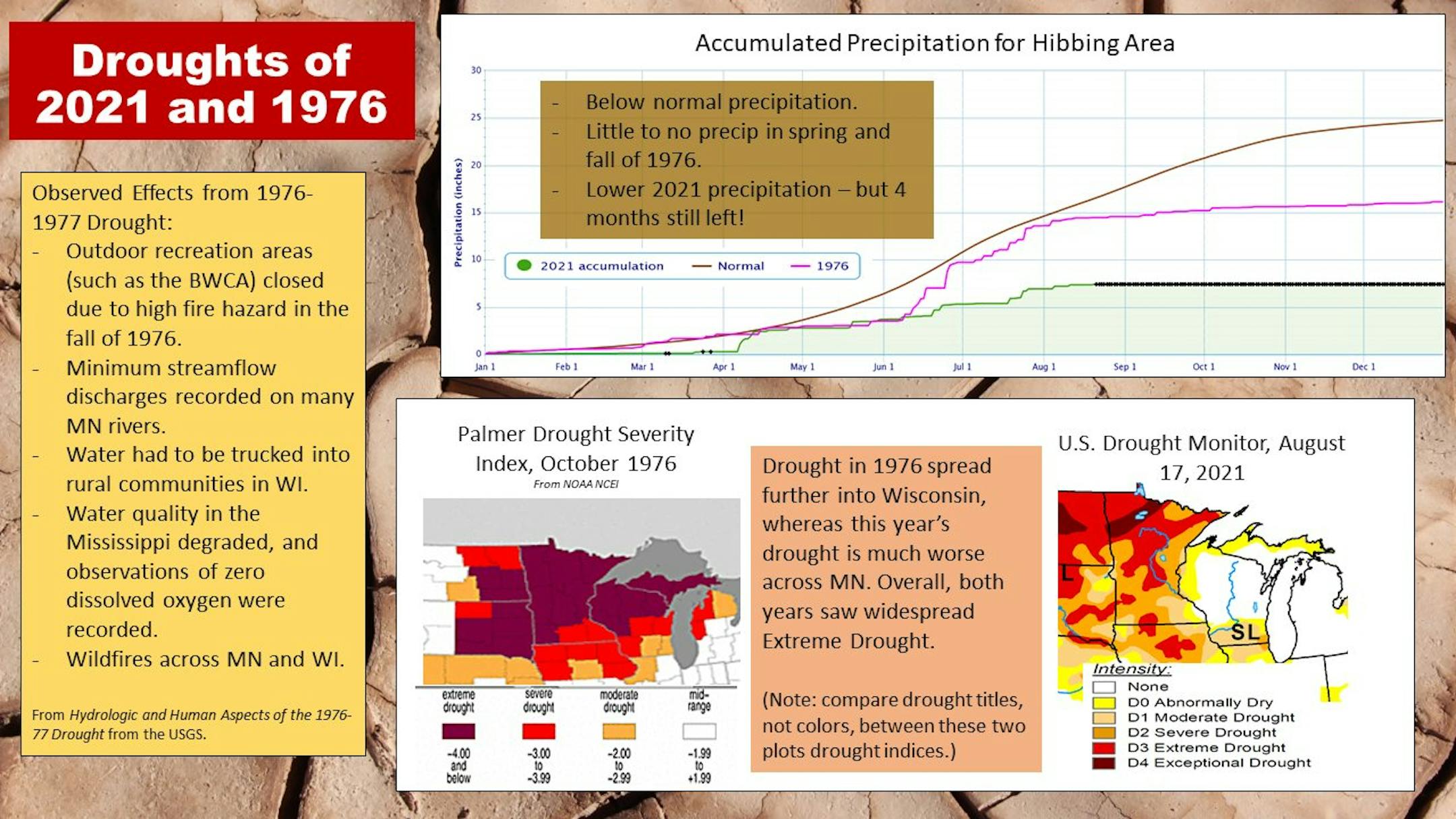
On Saturday, the BWCA was shut down for seven days, even for day use, "due to active and increasing fire activity, extreme drought, limited resources." The National Weather Service office in Duluth put together the above graphic comparing this year versus the last time that the BWCA shut down due to a high fire hazard - the fall of 1976. Below is what they posted on Facebook explaining the image:

"The BWCAW in northern MN has closed due to high fire hazards. The last time this occurred was in the autumn of 1976 – during a period of extreme drought in MN. Let's take a quick look at how the drought of 1976 (which continued into 1977) compares to the drought we are currently experiencing.

Both years recorded below normal precipitation – Spring and Fall of 1976 saw little to no precipitation, with June and July recording some of the only significant precipitation of the year. While we have observed lower precipitation this year, we still have 4 months to go! (We have used the Hibbing observation site as a way to investigate conditions closer to the BWCA and ongoing Greenwood Fire)

Drought was extensive in 1976, with Extreme Drought stretching across MN and WI – we again are seeing widespread Extreme Drought over MN this year.

(Thanks to the USGS, MN DNR, and NOAA NCEI for data and historical information)"

The Superior National Forest also gave a larger explanation on Facebook as to why the BWCA is closed.

_______________________________________________

Saturday Lake Superior Seiche

NWS Duluth also posted something interesting that happened on Lake Superior yesterday - a seiche! That caused lower lake levels in the Duluth area, upwelling of cold water along the North Shore, and higher lake levels in the Marquette area. Above are the chart showing the higher/lower water levels and the water temperatures, and below is a graphic explanation of a seiche.

_______________________________________________

Monday Weather Outlook

(The Minnesota Star Tribune)

A mainly sunny and warm August Monday awaits to begin the work week, with morning temperatures in the mid-60s and highs climbing to near 90F. Winds will be out of the south to west around 5 mph, so it'll not be as breezy as it has been recently across the region. A few clouds will still be around during the morning hours, and as we head toward the evening clouds will increase ahead of the potential of overnight showers and storms.

(The Minnesota Star Tribune)

Daytime hours on Monday will be quiet statewide with mainly sunny skies expected. Storms will be possible Monday Night across southern and northwestern Minnesota. Highs for the most part will be up to 10F degrees above average statewide, but about 5F degrees below average in Roseau.

_______________________________________________

Looking At The Week Ahead

(The Minnesota Star Tribune)

It'll be a warm start to the week, with temperatures climbing back up to around 90F both Monday and Tuesday. A cold front will move through by Wednesday morning, helping to knock temperatures back down to around 80F for Wednesday and the mid-70s for the first couple days of the State Fair. Rain chances exist Monday Night (especially south of the metro), Tuesday (some storms could be strong), and late Thursday stretching into the weekend.

(The Minnesota Star Tribune)

Dewpoints will be on the increase the next couple of days ahead of that cold front, with average dewpoints in the upper 60s on Tuesday. Dewpoints drop back off behind the front, but they'll likely increase late week again as that next system moves in.

(The Minnesota Star Tribune)

As I mentioned, storms on Tuesday could be on the strong side with a Marginal Risk of severe weather in place. Large hail and damaging winds would be the primary threats from stronger storms, but an isolated tornado or two can't be ruled out.

(The Minnesota Star Tribune)

Graphic above: NWS Twin Cities

_______________________________________________

State Fair Climatology

Note that the MNDNR page hasn't been updated yet since last year's non-fair, but the climatology on it still is valid! According to the Minnesota DNR/Minnesota State Climatology Office, the warmest temperature reported during the state fair was 104F back on September 10, 1931, with the coolest high being 52F (September 7, 1911). On average, it rains about 3-4 days during the fair. You can click the link above to read more about past temperatures, precipitation, and severe weather during the State Fair.

_______________________________________________

An Update On The 90F Count

(The Minnesota Star Tribune)

After three consecutive days with a high of 90F between Wednesday and Friday in the Twin Cities, we now sit at 25 days with a high of at least 90F in 2021. This is tied for the 10th most on record through August 21st. If we didn't see any more 90F degree days this year we would be tied for the 21st most on record. The most was 44 back in 1988 (which is also the most on record year-to-date).

_______________________________________________

The Fall Color Finder Has Updated...

(The Minnesota Star Tribune)

It might be a little early, but the MN DNR updated their fall color map across the state on Thursday... but no state parks are reporting anything at the moment. Just a sign that fall is on its way! You can follow the MN DNR Fall Color Finder throughout the fall color season by clicking here.

_______________________________________________

Predicting Wildfire Smoke Is Impossible
By Paul Douglas

Tracking tornadoes, floods, blizzards and hurricanes is what meteorologists do on a daily basis. Check the models, then use your experience to set expectations as best you can.

But nothing could prepare me for the massive smoke plumes of 2021 from hundreds of fires upwind; brown stains on our satellite images. We can see where fires are right now, but future smoke conditions depend on a myriad of factors, some beyond the ability of weather modeling. We are learning more about the health risks of wildfire smoke, and new data that suggests smoke may worsen the symptoms of Covid-19.

Between the smoke and a deepening drought I am very happy to be tracking swarms of T-storms this week. Timing them is next to impossible, but suffice to say conditions are ripe for some locally heavy rain this week as Minnesota teeter-totters on a boundary separating cool air north from hot, sweaty air to our south.

I see 80s today, Tuesday and next weekend, but the Minnesota State Fair kicks off with 70s on Thursday.

_______________________________________________

Paul's Extended Twin Cities Forecast

MONDAY: Warm sunshine. Wake up 65. High 88. Chance of precipitation 20%. Wind W 7-12 mph.

TUESDAY: T-storms likely, some strong. Wake up 68. High 86. Chance of precipitation 80%. Wind SE 8-13 mph.

WEDNESDAY: Sunny, breezy and less humid. Wake up 66. High 79. Chance of precipitation 20%. Wind NW 10-20 mph.

THURSDAY: Clouds increase, late T-storms. Wake up 61. High 78. Chance of precipitation 50%. Wind E 10-20 mph.

FRIDAY: Swarms of storms, some heavy. Wake up 65. High 77. Chance of precipitation 80%. Wind SE 10-20 mph.

SATURDAY: More sunshine, better lake day. Wake up 67. High 83. Chance of precipitation 20%. Wind S 8-13 mph.

SUNDAY: Steamy with a few strong T-storms. Wake up 70. High 88. Chance of precipitation 60%. Wind S 10-20 mph.

_______________________________________________

Minneapolis Weather Almanac And Sun Data
August 23rd

(The Minnesota Star Tribune)

*Length Of Day: 13 hours, 40 minutes, and 42 seconds
*Daylight LOST Since Yesterday: 2 minutes and 54 seconds

*When Do We Drop Below 13.5 Hours Of Daylight? August 27th (13 hours, 28 minutes, and 55 seconds)
*When Is The Sunrise At/After 6:30 AM?: August 28th (6:30 AM)
*When Is The Sunset At/Before 8:00 PM?: August 26th (8:00 PM)

_______________________________________________

This Day in Weather History
August 23rd

1955: Hail in Houston County results in drifts up to a foot deep at Rushmore.

_______________________________________________

National Weather Forecast

(The Minnesota Star Tribune)

The main story Monday will be what is left of Henri hanging around the Northeast, bringing more heavy rain to the region.

(The Minnesota Star Tribune)

The heaviest rain from Sunday through Tuesday will be in portions of the Northeast due to Henri, where rainfall amounts of 3-6" (isolated 10" amounts) will be possible leading to flooding.

(The Minnesota Star Tribune)

Henri made landfall along the Rhode Island coast near Westerly at approximately 12:15 PM ET Sunday afternoon with sustained winds of 60 mph after passing over Block Island, Rhode Island, around 11 AM ET. Above are satellite and radar loops (courtesy of Praedictix and AerisWeather) from the late morning and early afternoon timeframes showing the landfall of Henri.

(The Minnesota Star Tribune)

Henri will continue to move inland and weaken into the early part of the work week, becoming post-tropical on Monday and impacting portions of Nova Scotia as a remnant low Tuesday.

_______________________________________________

What the Acrid Smoke from Wildfires Can Teach Us

More from Scientific American: "As climate change intensifies summer after summer, millions of people around the world are finding themselves shrouded in toxic wildfire smoke, including those in North America, Russia and the Mediterranean just this past month. I'm from Australia, where our devastating 2019–2020 bushfires and smoke caught the world's attention. Wildfire smoke is bad for our health. It is also really distressing, but we don't talk about that as much. During Australia's Black Summer, choking on smoke for about three months, I found it impossible to think of anything but the unfolding crisis. But later, in the process of writing a book about how we feel and what we can do about climate change, I spent time thinking about that experience. What could the smoke be teaching us, if we were willing to listen and learn?"

Greece plans to name heatwaves in the same way as storms

More from The Guardian: "Spurred on by this summer's record temperatures, Greek scientists have begun discussing the need to name and rank heatwaves, better known for their invisibility, before rampant wildfires made the realities of the climate crisis increasingly stark. A preventative measure, the move would enable policymakers and affected populations to be more prepared for what are being described by experts as "silent killers." Greece has experienced two bouts of extreme heat since June, both unusually prolonged and intense, with the second wave lasting almost three weeks."

Study proposes new ways to estimate climate change impacts on agriculture

More from the University of Illinois College of Agricultural, Consumer and Environmental Sciences: "Most scientists agree climate change has a profound impact on U.S. agricultural production. But estimates vary widely, making it hard to develop mitigation strategies. Two agricultural economists at the University of Illinois take a closer look at how choice of statistical methodology influences climate study results. They also propose a more accurate and place-specific approach to data analysis. "If you pay attention to forecasts of how the climate will affect U.S. agriculture, the results are completely different. Some scientists predict it's going to have a positive impact for the nation in the long run, some report it's going to have a negative impact," says study co-author Sandy Dall'Erba, professor in the Department of Agricultural and Consumer Economics (ACE) and director of the Center for Climate, Regional, Environmental and Trade Economics (CREATE) at U of I."

_______________________________________________

Thanks for checking in and have a great day! Don't forget to follow me on Twitter (@dkayserwx) and like me on Facebook (Meteorologist D.J. Kayser).

- D.J. Kayser

(The Minnesota Star Tribune)
about the writer

about the writer

D.J. Kayser

See Moreicon

More from No Section

See More