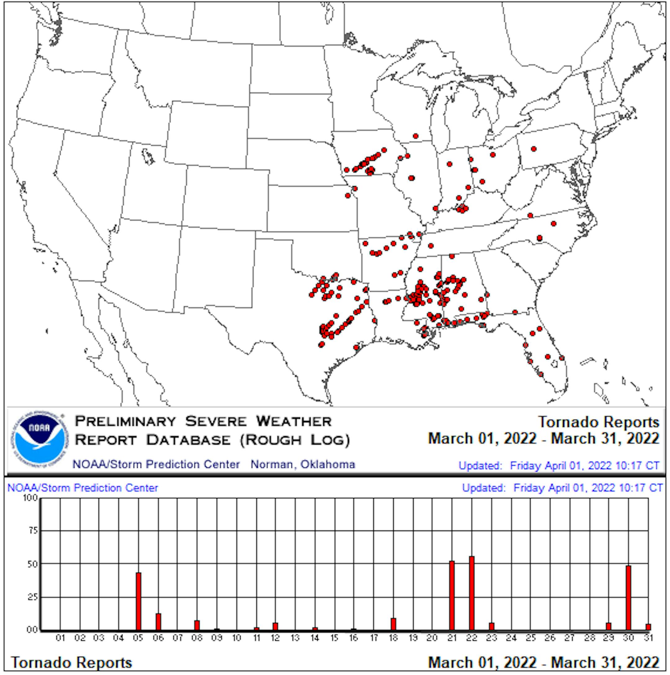
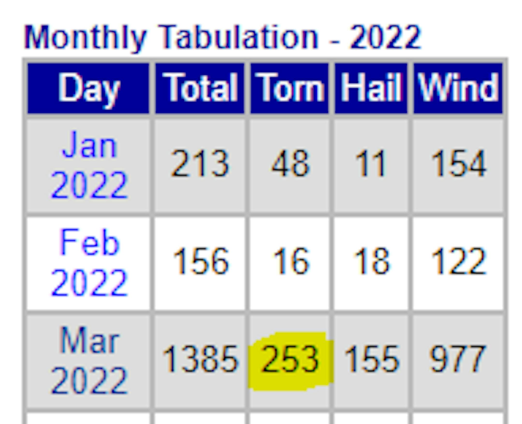
March Tornado Reports

According to NOAA's Storm Prediction Center, more than 250 tornado reports were received during the month of March 2022. Keep in mind that these are preliminary reports, so not a final tally, however, this could be the most tornadic March on record across the nation. The current record is 192 set in 2017.

Rain/Snow Sunday. Another Midweek Storm

Weather conditions over the next few days will be quite active with a couple of different storm systems moving through the Midwest. The first of which slides through PM Sunday with areas of rain and snow. The second is a much larger storm system that will bring more rain and snow to the region over a several day time period.

Precipitation Outlook

According to NOAA's WPC, the precipitation outlook through next week shows fairly decent precipitation amounts across the region with near 1" liquid tallies from eastern parts of Minnesota to western and central Wisconsin.

Sunday Night System

The system Sunday night will be responsible for areas of rain and snow across the Upper Midwest. Some locations could see a couple to a few tenths of an inch of liquid. Snowfall amounts should be fairly minimal if any at all.

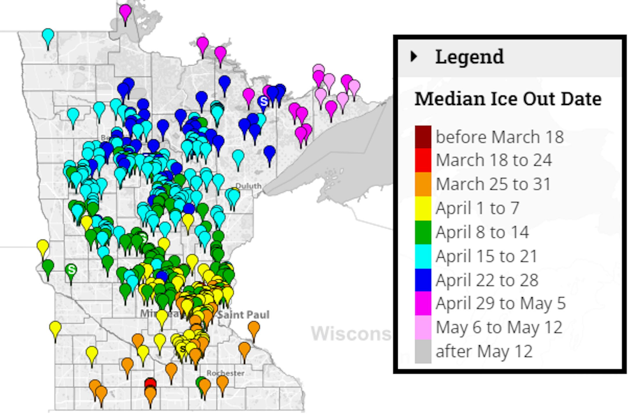
Average Ice Out Dates

We're still several weeks away from ice out across the state, but according to the MN DNR, here's a look at the average ice out dates for lakes across the state. Note that some lakes across the southern part of the state typically see ice out around the end of March. Lake Minnetonka typically doesn't see ice out until mid April. A few lakes in far northern & northeastern MN don't see ice out until late April or early May.
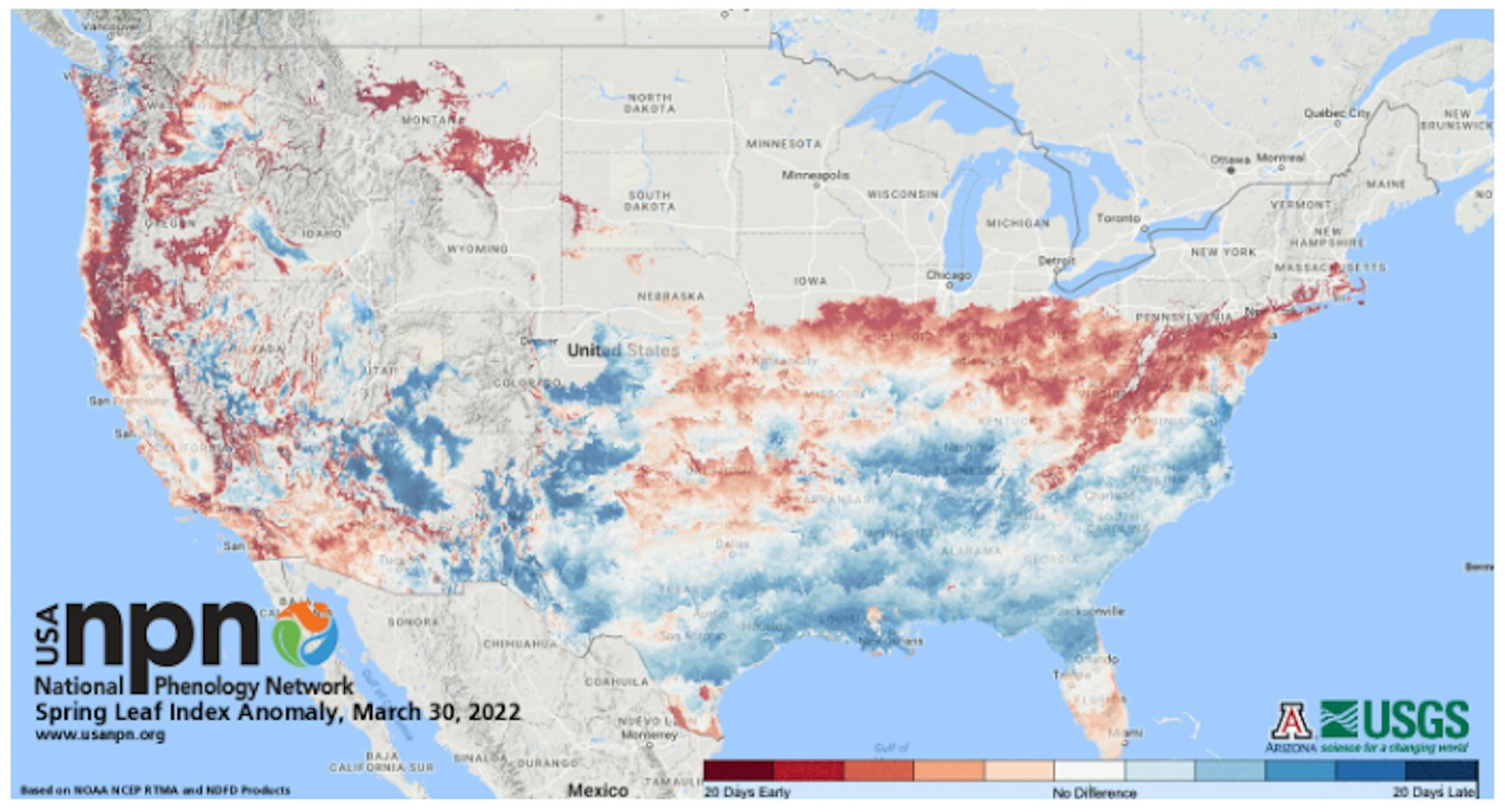
See more from the MN DNR HERE:

Status of Spring

"March 28, 2022 - Spring leaf out continues to progress across the country. Our spring leaf anomaly compares the arrival of spring leaf out this year to a long-term average of 1991-2020. After a slow start to spring across much of the Southeast, spring is progressing more rapidly, arriving days to weeks early across the southern part of the Midwest, the Southern Appalachians, and the mid-Atlantic. Boston, MA is two weeks early. In western states, spring leaf out is patchy, arriving a week late in some locations and over a month early in others. Parts of Montana and South Dakota are 2-3 weeks early. Spring bloom has also started to arrive in southern states, days to a week late in Texas and Florida and days to several weeks early in California. Spring bloom is over a week early in parts of Georgia, the Carolinas, and Virginia."

See more from NPN HERE:

Sunday Weather Outlook

The weather outlook for Minneapolis on Sunday will start on a dry and sunny note, but clouds thicken quickly with rain developing during the 2nd half of the day. Winds will be out of the east-southeast through the day and will increase to near 15mph in the afternoon.

Meteograms for Minneapolis

The hourly temps for Minneapolis on Sunday shows readings starting in the upper 20s in the morning and will warm into the low/mid 40s by mid afternoon. Sunny skies will be in place in the morning, but clouds will quickly increase with showers possible by midday. Southeasterly winds will be a bit stronger through the 2nd half of the day.

Weather Outlook on Sunday

Temps around the region on Sunday will be nearly -5F to -10F below average as a weak storm system slides through. Areas of rain will develop during the 2nd half of the day and could mix with wet snow late Sunday into Sunday night.

Extended Temperature Outlook For Minneapolis

The extended temperature outlook for Minneapolis over the next several days shows highs running below average Sunday & Monday. Tuesday will be warmer ahead of a bigger storm system that could bring rain, thunderstorms and snow to the region over a several day time period

Extended Weather Outlook For Minneapolis

The extended weather outlook over the next 7 days shows somewhat active weather in place with two different storm systems moving through. One moves through late Sunday into AM Monday. The 2nd storm system arrives midweek with areas of heavier rain, a few rumbles and thunder and even some snow. Drier weather moves in Friday, Saturday an Sunday.

Extended Temperature Outlook For Minneapolis

According to the ECMWF & GFS extended temperature outlook, temps will warm into the 40s and 50s through the first full week of April. By mid month, we could warm into the 60s possibly near 70F.

8 to 14 Day Temperature Outlook

According to NOAA's Climate Prediction Center, the 8 to 14 day temperature outlook shows warmer than average temps lingering across parts of the eastern half of the nation. However, the western half of the nation will be cooler than average and especially across the Pacific Northwest.

8 to 14 Day Precipitation Outlook

According to NOAA's Climate Prediction Center, the 8-14 Day precipitation outlook shows drier weather in place across the Eastern Seaboard. However, more active weather will be in place across the western two-thirds of the nation.

Most Tornadic March on Record For The U.S.?
By Todd Nelson, filling in for Douglas.

According to NOAA's Storm Prediction Center, the U.S. may have endured its most tornadic March on record. Preliminary reports suggests that nearly 250 tornadoes touched down across the nation, nearly 100 of those reports across Louisiana, Mississippi and Alabama. Keep in mind that those numbers will likely be reduced after all storm surveys have been completed. The current March tornado record was set in 2017 when 192 tornadoes were confirmed.

Believe it or not, Minnesota typically averages around 1 tornado in April, but that activity really ramps up in June when we average around 15. I should also mention that Minneapolis average around 3.5 inches of snow as the atmospheric tug of war continues.

With that being said, we have a couple of chances of snow through next week. One develops later tonight and another chance midweek. Slushy accumulations will be possible for some, but the good news is that it'll melt quick! Highs will warm into the 40s and low 50s through next weekend.

Welcome to spring in the Midwest.

Extended Forecast

SUNDAY: PM rain. Snow mixes late. Winds: ESE 5-10. High: 44.

SUNDAY NIGHT: Mostly clear and quiet. Winds: NW 10-15. Low: 32.

MONDAY: Damp start. Lingering afternoon clouds. Winds: S 5. High: 49.

TUESDAY: Steady rain develops. Gusty winds. Winds: SE 15-30. Wake-up: 37. High: 52.

WEDNESDAY: T-Shower possible. Snow mixes late. Winds: WNW 10-20. Wake-up: 35. High: 50.

THURSDAY: Rain/ snow mix. Accumulations possible. Winds: NNW 15-30. Wake-up: 33. High: 45.

FRIDAY: Breezy. Sun returns. Feels much better. Winds: N 10-20. Wake-up: 33. High: 47.

SATURDAY: Bright sunshine. Let's go MN Twins!. Winds: S 10-20. Wake-up: 28. High: 50.

This Day in Weather History

April 3rd

1999: An ice storm hits Duluth and the Arrowhead. An 800 foot television tower in Duluth collapses due to the weight of the ice.

1982: A sharp cold front causes the temperature at Lamberton in Redwood County to drop from 78 to 7 degrees. This 71 degree change in 24 hours is the maximum 24-hour temperature change in Minnesota.

1837: A snowstorm rages for four days at Ft. Snelling and dumps 9 inches.

Average High/Low for Minneapolis

April 3rd

Average High: 517F (Record: 80F set in 1921)

Average Low: 32F (Record: 9F set in 1954)

Record Rainfall: 0.84" set in 1974

Record Snowfall: 7.5" set in 2018

Sunrise/Sunset Times for Minneapolis

April 3rd

Sunrise: 6:49am

Sunset: 7:43pm

Hours of Daylight: ~12 hours & 53 minutes

Daylight GAINED since yesterday: ~ 3 minute & 6 seconds

Daylight GAINED since Winter Solstice (December 21st): ~ 4 Hour & 13 Minutes

Moon Phase for April 3rd at Midnight

3.0 Days Since New Moon

f

National High Temps Sunday

The weather outlook on Sunday shows cooler temps in place from the Midwest to the Northeast. The warm weather will be confined to the Southern US, where temps will be nearly +10F above average in Dallas, TX.

National Weather Outlook

Weather conditions through early next week shows somewhat active in place across the central US. A larger storm system will take shape in the Pacific Northwest with areas of rain and snow moving in.

Extended Precipitation Outlook

According to NOAA's Weather Prediction Center, in the eastern half of the nation with some of the heaviest found along the Gulf Coast States. There will also be some decent precipitation in the Midwest and in the Pacific Northwest.

Extended Snowfall Outlook

Here's the ECMWF extended snowfall outlook through next week. Areas of heavy snow will be possible across the northern tier of the nation. Heavier snow tallies could be possible in the Northeast, Midwest and the Northwest.

Climate Stories

"Great Barrier Reef suffers first mass bleaching under cooling La Niña"

"Corals have turned white across all four of the reef's main areas, despite the cooling influence of the La Niña climate phenomenon, in the natural wonder's sixth mass bleaching event of modern times"

See more from New Scientist HERE:

"'I Should Be Able to Go Outside': Why a Utah Teen Is Suing Over Polluted Air"

"Fifteen-year-old Natalie R. is fed up with the poor air quality in her home state of Utah. But rather than simply complain, she and a group of other young people are taking on who they see as the enablers of this pollution: government officials who continue to green-light fossil fuel development. Earlier this month, seven young activists filed a lawsuit against the state of Utah with the help of Our Children's Trust, a nonprofit law firm that focuses on climate justice. Natalie R. v. State of Utah alleges that the state and its elected officials unconstitutionally favor fossil fuel companies at the expense of residents' rights to a healthy and safe life. Andrew Welle, staff attorney at Our Children's Trust and lead counsel for the lawsuit, said the main issue is the public health problems young people are facing in the state."

See more from Gizmodo HERE:

"Global Losses From Catastrophes Reached $270 Billion in 2021"

"Hurricane Ida and the freakish winter storm that froze Texas last February topped last year's list of most damaging storms, according to the annual report on insurance industry losses caused by natural catastrophes put out by reinsurance giant Swiss Re. The report found that global economic losses from natural catastrophes such as floods, hurricanes and wildfires reached $270 billion in 2021. Of those losses, less than half, or $111 billion, were actually insured. Still, that $111 billion equaled the fourth-largest payout since the Swiss Re Institute, the insurer's research arm, began keeping records in 1970."

See more from Bloomberg HERE:

Thanks for checking in and don't forget to follow me on Twitter @TNelsonWX