More Jaw Dropping Global Heat Records

Wednesday

July 26, 2023 at 2:30AM

Heat Advisory Issued Wednesday & Thursday

Key Messages

  • Hot & humid conditions are likely this week, with the highest heat index and Wet Bulb Global Temps (WBGT) expected on Thursday.
    • Overnight 'lows' Wednesday into Thursday will be in the 70s, thus elevating the heat risk as little cooling relief will occur overnight.

      Forecast Uncertainties

      • Thunderstorms are possible within this period, especially late tonight into Wednesday and again Thursday afternoon.
        • Cloud cover/precipitation during the afternoon could lead to temperatures several degrees cooler than currently forecast.

          Important Updates

          • A Heat Advisory has been issued for the areas highlighted to the right beginning at 10 AM Wednesday lasting through 8 PM Thursday. ○ Further adjustments to headlines are possible.
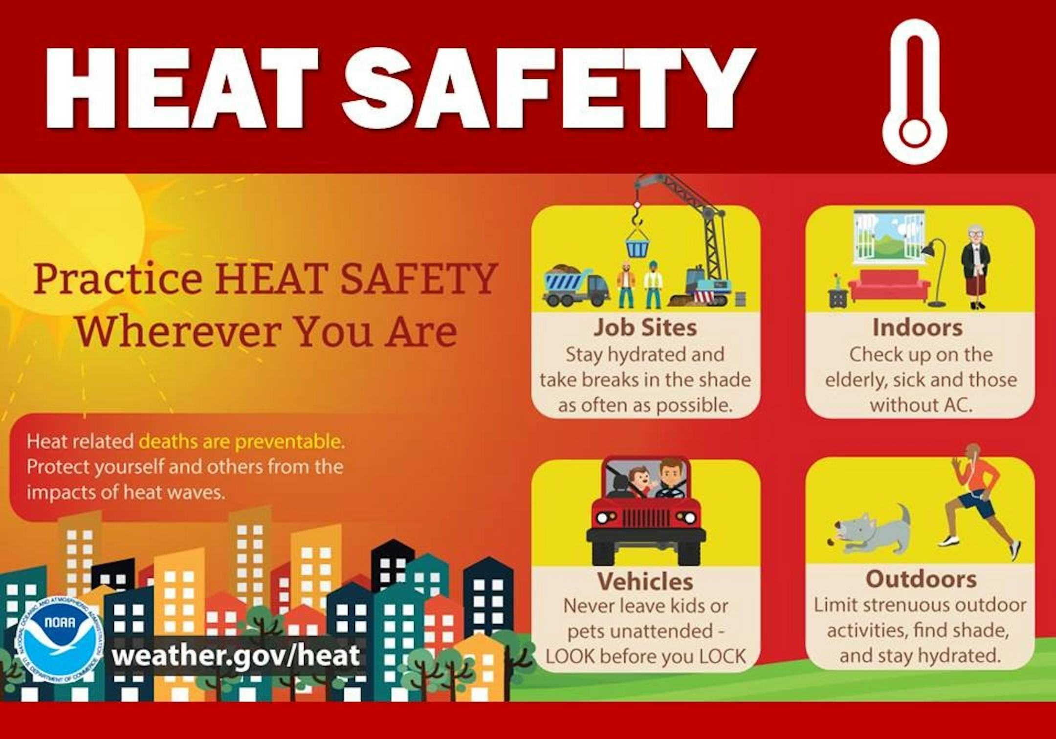
            Heat Advisory Wednesday & Thursday (NWS Twin Cities/The Minnesota Star Tribune)

            Heat Safety Tips

            Heat is one of the leading weather-related killers in the United States, resulting in hundreds of fatalities each year. Heat can be very taxing on the body; check out the heat related illnesses that can occur with even a short period of exposure. Everyone can be vulnerable to heat, but some more so than others. According to The Impacts Of Climate Change On Human Health In The United States: A Scientific Assessment the following groups are particularly vulnerable to heat; check in with friends and relatives who fall in one of these populations, especially if they don't have air conditioning.

            • Young children and infants are particularly vulnerable to heat-related illness and death, as their bodies are less able to adapt to heat than are adults.
              • Older adults, particularly those with pre existing diseases, take certain medications, are living alone or with limited mobility who are exposed to extreme heat can experience multiple adverse effects.
                • People with chronic medical conditions are more likely to have a serious health problem during a heat wave than healthy people.
                  • Pregnant women are also at higher risk. Extreme heat events have been associated with adverse birth outcomes such as low birth weight, preterm birth, and infant mortality, as well as congenital cataracts.

                    It is NEVER safe to leave a child, disabled person or pet locked in a car, even in the winter. If you have a toddler in your household, lock your cars, even in your own driveway. Kids play in cars or wander outside and get into a car and can die in 10 minutes! A reported 33 children died in hot cars in 2022. To see the latest information for 2023, go to this link. Deaths routinely are reported as early as April and tragedies continue into December in southern states.

                    Safety Tips

                    • Slow down. Strenuous activities should be reduced, eliminated, or rescheduled to the coolest time of the day. Individuals at risk should stay in the coolest available place, not necessarily indoors.
                      • Dress for summer. Lightweight, light-colored clothing reflects heat and sunlight, and helps your body maintain normal temperatures.
                        • Foods (like proteins) that increase metabolic heat production also increase water loss.
                          • Drink plenty of water or non-alcoholic fluids. Your body needs water to keep cool. Drink plenty of fluids even if you don't feel thirsty.
                            • Do not drink alcoholic beverages.
                              • Spend more time in air-conditioned places. Air conditioning in homes and other buildings markedly reduces danger from the heat. If you cannot afford an air conditioner, spending some time each day (during hot weather) in an air conditioned environment affords some protection.
                                • Don't get too much sun. Sunburn makes the job of heat dissipation that much more difficult.
                                  Heat Safety (NOAA/The Minnesota Star Tribune)

                                  Heat Related Illness

                                  During extremely hot and humid weather, your body's ability to cool itself is challenged. When the body heats too rapidly to cool itself properly, or when too much fluid or salt is lost through dehydration or sweating, body temperature rises and you or someone you care about may experience a heat-related illness. It is important to know the symptoms of excessive heat exposure and the appropriate responses. The Centers for Disease Control and Prevention (CDC) provides a list of warning signs and symptoms of heat illness, and recommended first aid steps. Some of these symptoms and steps are listed below.

                                  Heat Cramps

                                  Heat cramps may be the first sign of heat-related illness, and may lead to heat exhaustion or stroke.

                                  • Symptoms: Painful muscle cramps and spasms usually in legs and abdomen and Heavy sweating.
                                    • First Aid: Apply firm pressure on cramping muscles or gently massage to relieve spasm. Give sips of water unless the person complains of nausea, then stop giving water.
                                        • Seek immediate medical attention if cramps last longer than 1 hour.

                                          Heat Exhaustion

                                          • Symptoms: Heavy sweating, Weakness or tiredness, cool, pale, clammy skin; fast, weak pulse, muscle cramps, dizziness, nausea or vomiting, headache, fainting,
                                            • First Aid: Move person to a cooler environment, preferably a well air conditioned room. Loosen clothing. Apply cool, wet cloths or have person sit in a cool bath. Offer sips of water. If person vomits more than once,
                                                • Seek immediate medical attention if the person vomits, symptoms worsen or last longer than 1 hour

                                                  Heat Stroke

                                                  • Symptoms: Throbbing headache, confusion, nausea, dizziness, body temperature above 103°F, hot, red, dry or damp skin, rapid and strong pulse, fainting, loss of consciousness.
                                                    • First Aid: Call 911 or get the victim to a hospital immediately. Heat stroke is a severe medical emergency. Delay can be fatal. Move the victim to a cooler, preferably air-conditioned, environment. Reduce body temperature with cool cloths or bath. Use fan if heat index temperatures are below the high 90s. A fan can make you hotter at higher temperatures. Do NOT give fluids.
                                                      Heat Related Illness (NOAA/The Minnesota Star Tribune)

                                                      "NOAA Predicts Widespread Extreme Heat This Summer: 10 Ways to Adapt Your Home and Garden Now"

                                                      "With this record-breaking summer of heat affecting much of the nation, discover ways to stay cool and protect your home and yard. The heat is on. Much of the U.S. is expected to experience extreme heat this summer, and it's already happening. Both NOAA's 2023 Summer Outlook and The Farmers' Almanac summer forecast warn of a season of record-breaking temperatures that will linger for months and possibly trigger drought, wildfires, tornadoes, heavy storms, and health concerns for those in its path. Heat waves are nothing new, but this is no ordinary heat wave. Between climate change making heat waves more likely and intense, and the El Niño pattern of warmer sea temperatures now in effect, summer weather extremes are intensified. A big concern is that this new, more dangerous type of heat wave is preventing temperatures from cooling down enough overnight to offer a break. In fact, in some places, overnight temperature records are more frequent or extreme than the daytime records being set for highs."

                                                      (NOAA/The Minnesota Star Tribune)

                                                      The Hottest Week of 2023 Coming Up

                                                      This week ahead will likely be the hottest week of 2023 for Minneapolis. According to NOAA's NDFD, we could see highs in the 90s all week with hottest readings peaking around 100F on Wednesday and Thursday. The National Weather Service will likely issue heat headlines this week.

                                                      Forecast Temps For Minneapolis (WeatherBell & NOAA's NDFD/The Minnesota Star Tribune)

                                                      Average Number of 90F Days At MSP

                                                      Looking at the last 30 years, the average number of 90F days at the MSP Airport is (14). July is the hottest month with an average of (6) 90F days. We've only had (3) days in the 90s this July, but have already had (14) days in the 90s this year. Last year we had (18) days in the 90s and in 2021 there were (27) days in the 90s. The most number of 90F days in any single year was (44) set in 1988.

                                                      Average Number of 90F Days At MSP (NOAA NWS/The Minnesota Star Tribune)

                                                      2nd Driest May 15th Through July 24th on Record

                                                      It has been very dry across much of the region this summer with only 2.00" of rain falling at the MSP Airport from May 15th to July 24th. This is the 2nd driest such period on record with the driest being 1.90" set in 1988.

                                                      2nd Driest May 15th Through July 24th on Record at MSP (NOAA NWS/The Minnesota Star Tribune)

                                                      60 Day Precipitation Anomaly

                                                      The map below shows the 60 day precipitation anomaly, which indicates that some locations are nearly -3.00" to nearly -7.00" below average (in red/pink) since mid May. Spots in Southwestern and northwestern Minnesota still have a bit of a surplus, but much of the region is well below average precipitation.

                                                      60 Day Precipitation Anomaly (WeatherBell/The Minnesota Star Tribune)

                                                      Drought Update

                                                      Drought conditions continue to deepen across the region with a few pockets of Extreme Drought now showing up (in red). The last time that parts of Minnesota were in an Extreme Drought was back in mid December, nearly 7 months ago.

                                                      Minnesota Drought Update (US Drought Monitor/The Minnesota Star Tribune)

                                                      Extended Precipitation Outlook

                                                      The extended precipitation outlook through next week shows a few pockets of heavy rainfall, mainly across the southwestern part of the state. The heaviest rains will be hit or miss depending on where the strongest storms blow through.

                                                      Extended Precipitation Outlook (WeatherBell & NOAA's WPC/The Minnesota Star Tribune)

                                                      Simulated Radar

                                                      The simulated radar from early PM Tuesday to midday Thursday shows another round of showers and thunderstorms developing across the region late Tuesday through early AM Wednesday. Some of the storms could produce locally heavy rainfall before significant heat pours in Wednesday and Thursday.

                                                      Simulated Radar From PM Tuesday to Midday Thursday (COD Weather/The Minnesota Star Tribune)

                                                      Twin Cities Weather Outlook For Wednesday

                                                      The weather outlook for the Twin Cities on Wednesday, July 26th will be a little unsettled to start with scattered strong storms blowing through in the morning. Some of the storms could be severe with locally heavy rainfall, especially south and west of the Twin Cities. After the storms move through, it'll turn hot and humid once again with highs reaching the mid 90s with feels like temps possibly getting close to 100mph.

                                                      Twin Cities Weather Outlook For Wednesday (Praedictix/The Minnesota Star Tribune)

                                                      Meteograms For Minneapolis

                                                      The hourly temps through the day Wednesday shows readings starting in the low/mid 70s in the morning and topping out in the mid 90s in the afternoon. It'll be unsettled in the morning with stronger storms rumbling through. Skies will then clear out with hot and muggy weather developing through the afternoon. Winds will turn more northwesterly through the 2nd half of the day with gusts approaching 15mph.

                                                      Hourly Temps & Sky Conditions For Minneapolis on Wednesday (Praedictix/The Minnesota Star Tribune)
                                                      Hourly Wind Gusts & Direction For Minneapolis on Wednesday (Praedictix/The Minnesota Star Tribune)

                                                      Weather Outlook For Wednesday

                                                      Temps on Wednesday will warm into the 80s and 90s across much of Minnesota, which will be nearly +10F to +15F above average. This will likely be our 18th day with highs in the 90s this year. Note that our average is 14.

                                                      Weather Outlook For Wednesday (Praedictix/The Minnesota Star Tribune)
                                                      Highs From Average on Wednesday (Praedictix/The Minnesota Star Tribune)

                                                      Extended Temperature Outlook For Minneapolis

                                                      The 5 day temperature outlook for Minneapolis shows hot temperatures continuing this week with readings in the 90s. The warmest days will be Wednesday and Thursday with highs in mid/upper. Note that the last time we hit 100F in the Twin Cities was on June 20th, 2022. If we hit 100F this week, it'll be the 70th time in history!

                                                      5 Day Temperature Outlook For Minneapolis (Praedictix/The Minnesota Star Tribune)

                                                      Stickier Dewpoints Linger Early This Week

                                                      The dewpoint forecast over the next several days will peak around 70F through the end of week, which will feel almost tropical. Things will improve into the weekend as dewpoints fall into the 50s and 60s.

                                                      Daily Dewpoint Forecast For Minneapolis (Praedictix/The Minnesota Star Tribune)

                                                      Extended Weather Outlook For Minneapolis

                                                      The extended weather outlook for the Twin Cities through our last full week of July shows hot temps continuing with readings in the mid/upper 90s. A cool front will move in late week and weekend with cooler temps and lower humidity values. Rain chances look to improve a bit as we head into the early part of August. Fingers crossed!

                                                      7 Day Weather Outlook For Minneapolis (Praedictix/The Minnesota Star Tribune)

                                                      Weather Outlook

                                                      Weather conditions across parts of the Central US will be unsettled at times with chances of showers and thunderstorms drifting through. There could be a few isolated severe storms with locally heavy rainfall. The large ridge of high pressure in the Western US will be responsible for a few monsoonal storms as well.

                                                      National Weather Outlook Through The Weekend (Tropical Tidbits/The Minnesota Star Tribune)

                                                      8 to 14 Day Temperature Outlook

                                                      According to NOAA's Climate Prediction Center, the 8 to 14-day temperature outlook shows warmer-than-average temperatures shifting back to the Southern and Western US. Temps will return to normal across the Midwest and will be below average in the Northeast.

                                                      8 to 14 Temp Outlook (NOAA CPC/The Minnesota Star Tribune)

                                                      8 to 14 Day Precipitation Outlook

                                                      Heading into the first full week of August, more unsettled weather will be possible across parts of the Intermountain-West and also along the East Coast.

                                                      8 to 14 Precipitation Outlook (NOAA CPC/The Minnesota Star Tribune)

                                                      Watching The Tropics

                                                      7 Day Weather Outlook For Minneapolis (NOAA NHC/The Minnesota Star Tribune)

                                                      More Jaw Dropping Global Heat Records
                                                      By Paul Douglas

                                                      Water temperatures at one location in the Florida Keys were a toasty 101F Monday, which maybe a new world record for warmest water temperature. Bath water. Every day this month in Phoenix has been hotter than 110F, which hasn't happened before in the historical record. Greenland ice is melting 100 times faster than previously estimated, and melting of Antarctic ice is unprecedented: a six-sigma event, which means it occurs once every 7.5 million years. A new, alarming level of heat. Vaguely interesting Paul, but what's streaming on Netflix?

                                                      In spite of thick smoke plumes, ozone pollution and swarms of storms we should see enough tropical sunshine for mid to upper 90s today and tomorrow. No records, but factoring a dew point near 70F it may feel like 100-105F during the PM hours. Storms dry up this morning, but more flashing and splashing is likely Thursday and Friday. Canadian air leaks southward this weekend with sunshine, highs in the 80s and a possible whiff of wildfire smoke. Happy to see 80s these days.

                                                      Extended Forecast

                                                      WEDNESDAY: Early thunder then hot sun. Winds: NW 7-12. High: 96.

                                                      WEDNESDAY NIGHT: Warm. Few t-showers by morning. Winds: NNW 5. Low: 75.

                                                      THURSDAY: Heat index: 100-105. Few T-storms. Winds: SW 10-20. High 97.

                                                      FRIDAY: Steamy with a few heavy T-storms. Winds: NE 8-13. Wake-up: 73. High 90.

                                                      SATURDAY: Partly sunny, less humid. Winds: NW 7-12. Wake-up: 64. High: 85.

                                                      SUNDAY: Comfortable with warm sunshine. Winds: SW 7-12. Wake-up: 62. High: 86.

                                                      MONDAY: More clouds, stray T-storm. Winds: SE 7-12. Wake-up: 67. High: 88.

                                                      TUESDAY: Sticky with a few T-storms. Winds: S 8-13. Wake-up: 70. High 87.

                                                      This Day in Weather History

                                                      July 26th

                                                      1981: A chilly morning occurs across the Northland, with 33 degrees at Roseau and Wannaska.

                                                      Average High/Low for Minneapolis

                                                      July 26th

                                                      Average High: 83F (Record: 100F set in 1894 & 1955)

                                                      Average Low: 65F (Record: 45F set in 1962)

                                                      Record Rainfall: 2.44" set in 1990

                                                      Record Snowfall: NONE

                                                      Twin Cities Almanac For July 26th (Praedictix/The Minnesota Star Tribune)

                                                      Sunrise/Sunset Times for Minneapolis

                                                      July 26th

                                                      Sunrise: 5:52am

                                                      Sunset: 8:46pm

                                                      Hours of Daylight: ~14 hours & 54 minutes

                                                      Daylight LOST since yesterday: 2 Minutes & 9 Seconds

                                                      Daylight LOST since Summer Solstice (June 21st): ~ 42 minutes

                                                      Moon Phase for July 26th at Midnight

                                                      1.4 Days Since First Quarter Moon

                                                      Moon Phase For July 26th at Midnight (The Minnesota Star Tribune)

                                                      National High Temps on Wednesday

                                                      Temperatures on Wednesday will be very steamy across the Central and Southwestern US with readings running nearly +10F to +15F above average. There could be a few record highs across the Southwest through midweek as well.

                                                      National Weather Outlook For Wednesday (Praedictix/The Minnesota Star Tribune)
                                                      National Highs From Average on Wednesday (Praedictix/The Minnesota Star Tribune)

                                                      National Weather Wednesday

                                                      The weather outlook on Wednesday will feature a few rowdy storms across parts of the Midwest on the leading edge of some fairly impressive heat that will continue to bubble north through the week ahead. There will also be a few strong storms in the Northeast with locally heavy rainfall.

                                                      National Weather Map For Wednesday (Praedictix/The Minnesota Star Tribune)

                                                      National Weather Outlook

                                                      The weather outlook through Thursday shows scattered storms from the Southwest to the Midwest. Some of the storms could be strong to severe with locally heavy rainfall. A number of these storms are developing on the outer edge of the excessive heat dome that has set up in the Southern US.

                                                      National Weather Outlook Through Thursday (NOAA WPC/The Minnesota Star Tribune)

                                                      Extended Precipitation Outlook

                                                      According to NOAA's Weather Prediction Center, the extended precipitation outlook shows heavier precipitation across parts of the Midwest and Great Lakes. These heavy rainfall events will be the result of thunderstorms that will develop on the outer edge of the extreme heat dome.

                                                      Extended Precipitation Outlook (NOAA WPC/The Minnesota Star Tribune)

                                                      Climate Stories

                                                      (NOAA/The Minnesota Star Tribune)

                                                      "In Arizona's extreme heat, just touching the asphalt can cause severe burns"

                                                      "Arizona has been facing a heat wave so extreme that Phoenix has broken multiple heat records, several wildfires are burning across the state, and people are getting severe, potentially life-threatening burns from just touching the ground. During extreme heat, studies have shown that asphalt can be 40 to 60 degrees hotter than the temperature of the air; the Arizona Burn Center at Valleywise Health says outdoor surfaces can reach as high as 180 degrees Fahrenheit. Phoenix has seen temperatures above 110 degrees Fahrenheit for 24 consecutive days as of Sunday, July 23, shattering heat records. That extended heat has led to a surge in emergency room visits for burns. Dr. Kevin Foster, director of burn services at the Arizona Burn Center, told CNN that although summers are usually busy for burns, the past few weeks have been "really unusual," both in terms of the number of patients coming in and the severity of their injuries. CNN reported on Monday that all 45 of the burn center's beds were full, and that a third of those patients received their burns from falling on the ground. Patients burned after falls are also filling up the ICU."

                                                      "Here's What Happens To The Body In Extreme Temperatures — And How Heat Becomes Deadly"

                                                      "Of all extreme weather conditions, heat is the most deadly. It kills more people in the U.S. in an average year than hurricanes, tornadoes and floods combined. The human body has a built-in cooling mechanism – sweat. But that system can only do so much, especially in soaring temperatures with high humidity. Here's a look at what happens to the human body in extreme temperatures — and the three main pathways to fatal consequences. Organ failure caused by heatstroke When the surrounding temperatures approach your internal body temperature — which is about 98.6 degrees Fahrenheit for most of us — your body starts to cool off through evaporative cooling, better known as sweating. But when it's very humid out, that sweat won't evaporate as well and cool you down."

                                                      "How You Can Protect Your Home From Climate Change"

                                                      "Climate change is not a distant threat, but a present danger that is already wreaking havoc on our lives and homes. From devastating floods to scorching heat waves to raging wildfires, homeowners need to prepare for the consequences of our warming planet. Preparing for these challenges requires investments at both the household and government levels.The costs of natural disasters will multiply if homeowners and governments delay preparing for the increased frequency of devastating weather events. How Homeowners Can Protect Their Property Homeowners can take proactive measures to safeguard their properties against the effects of climate change. Installing rain gutters to redirect water away from the home can mitigate flood risks, an air conditioner can shield households from extreme heat, and a metal roof can protect against wildfires."

                                                      Thanks for checking in and don't forget to follow me on Twitter @TNelsonWX

                                                      @TNelsonWX (The Minnesota Star Tribune)
                                                      about the writer

                                                      about the writer

                                                      Todd Nelson

                                                      See Moreicon