Mild & Sunny Sunshine. Picture Perfect For October

Our picture perfect October weekend continues. If yesterday wasn't good enough, today will be even better! Highs across the state will warm to nearly 10 degree above average levels with bright sunshine and near peak fall color. Enjoy! Check the blog for more details. -Todd Nelson

October 17, 2021 at 2:30AM
Minnesota Landscape Arboretum (@TNelsonWX/The Minnesota Star Tribune)

Weekend Outlook For The Twin Cities

Quiet and comfortable fall-like weather continues into early next week with bright sunshine and light winds. It'll be great weather for any outdoor yard chores or backyard BBQs.

3 Day Weather Forecast For Minneapolis (Praedictix/The Minnesota Star Tribune)

St. Croix State Park

Fall color is going fast! According to the MN DNR, we are officially past peak color at St. Croix State Park located along the MN/WI border just north of the Twin Cities metro.

St. Croix State Park (MN DNR/The Minnesota Star Tribune)

MN Fall Color Tracker

According to the MN DNR, the entire state is in the midst of the fall color season, with peak and past peak now being reported across much of the northern half of the state. Around the metro, fall colors are nearing peak. Enjoy the colors while they last.

MN Fall Color Update (MN DNR/The Minnesota Star Tribune)

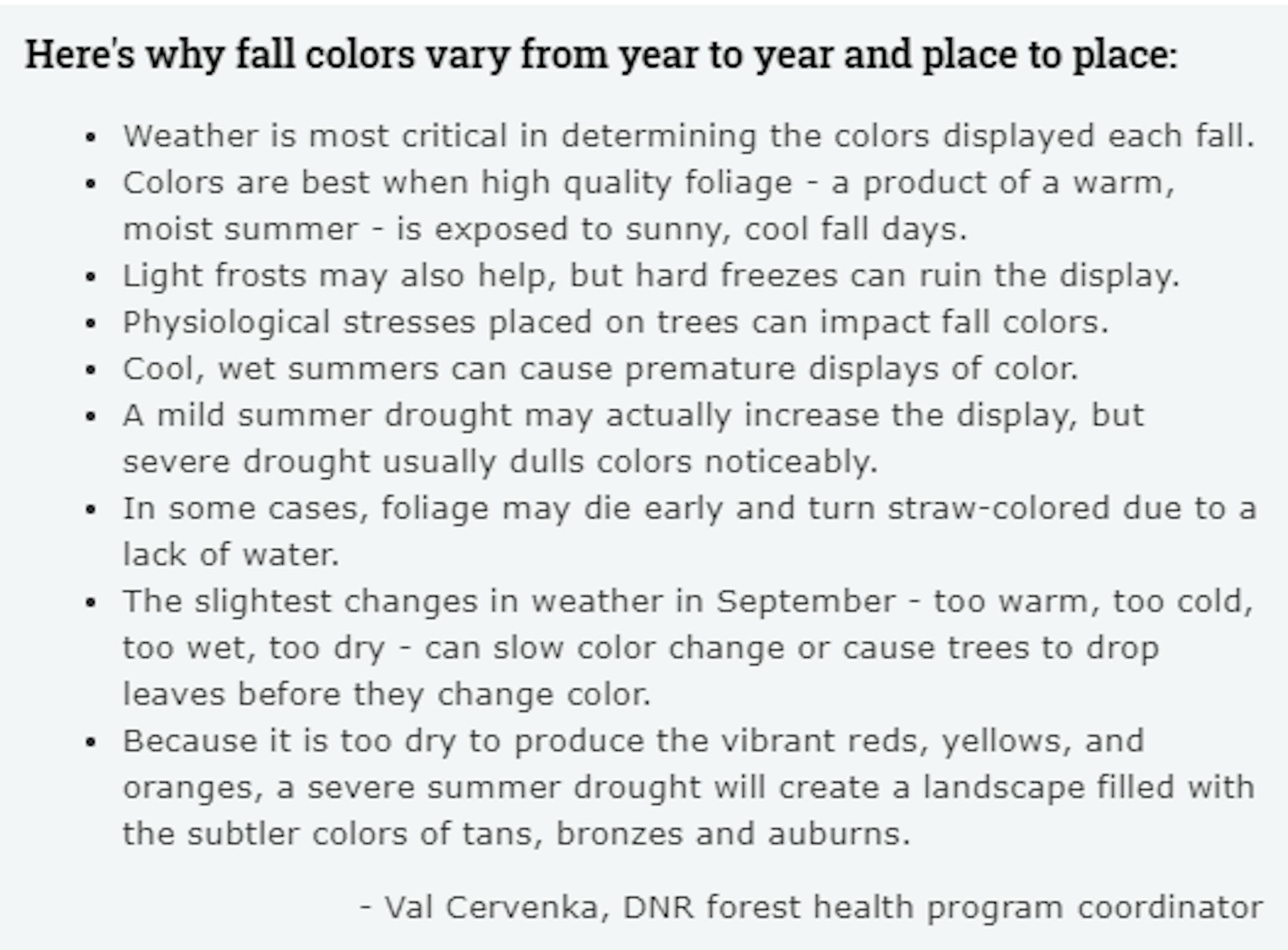
Fall Color Depends on Weather

Ever wonder why some years, fall color is so vibrant vs some years, fall color tends to be a bit more dull? Val Cervenka, Coordinator from the DNR Forest Health Program, shares how the weather can play a roll in those fall colors. Due to the hot and dry summer that most of experienced, it is likely that fall foliage could be less impressive this year with more tans, bronzes and auburns.

Fall Color & Weather (MN DNR/The Minnesota Star Tribune)

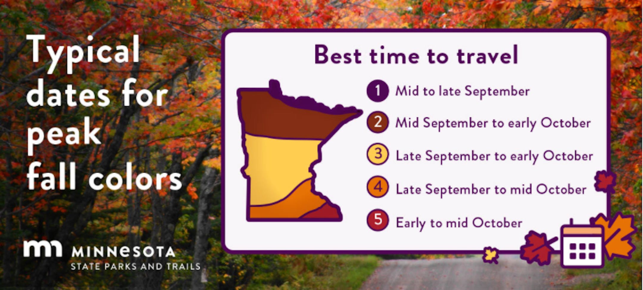
Typical Peak Dates For Fall Color

According to the MN DNR, fall colors typically start to peak across the northern part of the state in mid/late September. Peak color typically arrives in central and southern Minnesota late September and into early/mid October. Note that over the next several weeks, you'll notice some big changes in the landscape as we head deeper into fall.

Typical Fall Color Peak (MN DNR/The Minnesota Star Tribune)

Simulated Radar From Sunday Night to AM Monday

Here's the weather outlook into the week ahead, which shows quiet & mild weather through Tuesday. By Wednesday a storm system slides through the Upper Midwest with areas of light rain possible across the region.

Simulated Radar From AM Sunday to AM Friday (Praedictix/The Minnesota Star Tribune)

Precipitation Outlook Through Friday

The precipitation outlook through next week shows areas of light rain across parts of the state. The best rain chances arrive midweek with total amounts approaching a couple of tenths of an inch with higher pockets possible in western MN.

Precipitation Outlook Through The Week Ahead (WeatherBell/The Minnesota Star Tribune)

Drought Update For Minnesota

According to the US Drought Monitor, nearly 16% of the state is still considered to be in an extreme drought (in red across northern Minnesota), which is down from nearly 18% from last week. There has been a slight improvement in Severe Drought, which is at 42%, down from 50%. Nearly 64% of the state is still under a Moderate Drought, which includes much of the Twin Cities Metro.

MN Drought Update (US Drought Monitor/The Minnesota Star Tribune)

Precipitation Departure From Average Since January 1st

Here's a look at the precipitation departure from average since January 1st and note that most locations are still several inches below average. The Twin Cities The metro is still nearly -6.15" below average since January 1st, which is the 45st driest January 1st - October 15th on record.

Precipitation Deficit Since January 1st (Praedictix/The Minnesota Star Tribune)

Sunday Weather Outlook

Sunday will be a dry, sunny and comfortable day with highs running above average by nearly +10F for mid October.

Sunday Weather Outlook For Minneapolis (Praedictix/The Minnesota Star Tribune)

Meteograms for Minneapolis

The hourly temps for Minneapolis on Sunday, shows readings starting in the lower 40s and warming into the mid/upper 60s by the afternoon. Sunny skies will be with us through the entire day with WSW winds gusting close to 15mph at times in the afternoon.

Hourly Temps & Sky Conditions For Minneapolis on Sunday (Praedictix/The Minnesota Star Tribune)
Hourly Wind Gusts & Direction For Minneapolis on Sunday (Praedictix/The Minnesota Star Tribune)

Weather Outlook For Sunday

High temps across the region on Sunday will warm to above average levels across the entire region with readings nearly +10F to +15F above average.

Weather Outlook For Sunday (Praedictix/The Minnesota Star Tribune)
Highs From Average on Sunday (Praedictix/The Minnesota Star Tribune)

Extended Temperature Outlook For Minneapolis

The extended temperature outlook shows well above average temps through early next week. Note that highs could warm into the lower 70s on Monday and Tuesday, which will be nearly +15F above average. Light rain showers will be possible around midweek with temps falling closer to average temps by the end of the week.

5 Day Temperature Outlook For Minneapolis (Praedictix/The Minnesota Star Tribune)

Extended Weather Outlook For Minneapolis

The extended weather outlook through the 3rd full week of October shows mild and quiet weather in place through Tuesday. Weather conditions turn more unsettled during the 2nd half of the week with rain chances and falling temps. Next weekend could be quite chilly with highs possibly below average for a change.

7 Day Weather Outlook For Minneapolis (Praedictix/The Minnesota Star Tribune)

Extended Temperature Outlook For Minneapolis

According to the ECMWF & GFS extended temperature outlook, temps will be mild through the early part of the upcoming week, but will then tumble to below average readings for a change later in the week and weekend ahead.

ECMWF Extended Temperature Outlook For Minneapolis (WeatherBell/The Minnesota Star Tribune)
GFS Extended Temperature Outlook For Minneapolis (Praedictix/The Minnesota Star Tribune)

8 to 14 Day Temperature Outlook

According to NOAA's Climate Prediction Center, the 8 to 14 day temperature outlook shows warmer than average temps continuing across much of the Central US.

8 to 14 day temperature outlook (NOAA Climate Prediction Center/The Minnesota Star Tribune)

8 to 14 Day Precipitation Outlook

According to NOAA's Climate Prediction Center, there will be an increase in precipitation chances across the west coast.

8 to 14 Day Precipitation Outlook (NOAA Climate Prediction Center/The Minnesota Star Tribune)

Picture Perfect With Peak Fall Color
By Todd Nelson, filling in for Douglas.

Hard to complain about the October we've had so far. In fact, temps are running nearly 9.5 degrees above average in the metro, which is one of the warmest starts to any October on record at the MSP Airport. Meanwhile, folks 600 miles to our west had their first taste of winter earlier this week with heavy snow falling across the Western Dakotas and High Plains. Deadwood, SD, located in the Black Hills, walked away with the golden snow shovel award with an eye-popping 27 inches. Good grief!

It won't be long before our local 7-day forecasts are littered with the "S" word. Until then, let's continue to enjoy this picture perfect October weekend. If yesterday wasn't good enough, today will be even better! Highs across the state will warm to nearly 10 degree above average levels with bright sunshine and near peak fall color. Enjoy!

Monday and Tuesday will still be quite spectacular, but light rain arrives midweek with a temperature reality check following closely behind. Next weekend, you may be digging for your favorite sweater.

Extended Forecast

SUNDAY: Picture perfect. Winds: WSW 5-10. High: 67.

SUNDAY NIGHT: Clear and cool. Winds: WSW 5. Low: 46.

MONDAY: Another beauty. Mild & sunny. Winds: S 7-12. High: 72.

TUESDAY: Well above average temps continue. Winds: SE 5-10. Wake-up: 52. High: 70.

WEDNESDAY: Clouds thicken. Spotty PM showers. Winds: ESE 5-10. Wake-up: 50. High: 64.

THURSDAY: Mostly cloudy. Lingering light rain. Winds: NNW 7-12. Wake-up: 43. High: 54.

FRIDAY: Peeks of brisk sunshine. PM sprinkle? Winds: NNE 5-10. Wake-up: 39. High: 52.

SATURDAY: Feels like late October. Winds: SW 5. Wake-up: 34. High: 51.

This Day in Weather History

October 17th

1971: Heavy rain falls in NW Minnesota. 4.02 inches is recorded at Georgetown (20 miles N of Moorhead).

1952: Record lows between 10 to 15 degrees are reported across central Minnesota, including a low of 10 at St. Cloud, 12 at Glenwood, and 14 at Alexandria, Litchfield, and Mora.

Average High/Low for Minneapolis

October 17th

Average High: 58F (Record: 84F set in 1910)

Average Low: 39F (Record: 22F set in 1948, 1952)

Record Rainfall: 1.24" set in 1879

Record Snowfall: Trace set in 2004

Twin Cities Almanac For October 17th (Praedictix/The Minnesota Star Tribune)

Sunrise/Sunset Times for Minneapolis

October 17th

Sunrise: 7:31am

Sunset: 6:24pm

Hours of Daylight: ~10 hours & 52 minutes

Daylight LOST since yesterday: ~ 3 minute & 1 seconds

Daylight LOST since Summer Solstice (June 20th): ~4 Hour & 50 Minutes

Moon Phase for October 17th at Midnight

2.3 Days Until Full "Hunter's" Moon

"October 20: Full Hunter's Moon 9:57AM CDT - With the leaves falling and the deer fattened, it is time to hunt. Since the fields have been reaped, hunters can ride over the stubble, and can more easily see the fox and other animals, which have come out to glean and can be caught for a thanksgiving banquet after the harvest."

Moon Phase for October 16th at Midnight (Todd Nelson/The Minnesota Star Tribune)

National High Temps Sunday

The weather outlook on Sunday shows quiet weather across much of the nation. Temps in the Southern US will be running below average, but above average across much of the Midwest. Areas of rain will impact the West Coast, where temps will fall to below average levels.

National Weather Outlook For Sunday (Praedictix/The Minnesota Star Tribune)
National Highs From Average on Sunday (Praedictix/The Minnesota Star Tribune)

National Weather Outlook

Scattered showers and storms will eventually end across the Northeast with much quieter weather in place across much of the central us into early next week. Light rain/snow will move into the Intermountain-West as we head into early next week.

Weather Outlook For Monday (NOAA WPC/The Minnesota Star Tribune)

Extended Precipitation Outlook

According to NOAA's Weather Prediction Center, the heaviest rains over the next several days will be found in the NE and Pacific NW.

Extended Precipitation Outlook (NOAA WPC/The Minnesota Star Tribune)

Climate Stories

(NOAA/The Minnesota Star Tribune)

"A harsh winter is ahead"

Average winter energy costs for households primarily heating with. Because of higher fuel prices, the Energy Information Administration is forecasting that U.S. households will spend more to heat their homes this winter. Driving the news: When looking at winter forecasts, there are reasons to be concerned that parts of the U.S. — not to mention Europe, which is fully in the grips of an energy crisis, will see significant cold snaps. The big picture: This winter is likely to be another La Niña winter, which will feature colder-than-average sea surface temperatures in the equatorial Pacific Ocean. Such winters tend to be wetter and cooler than average in the Pacific Northwest, colder than usual in the Northern Plains and parts of the Midwest, wetter in the Ohio Valley, and drier in the South.

"America's Next Great Migrations Are Driven by Climate Change"

"The increasingly frequent and intense floods, heat waves, wildfires and other extreme climate events jolt us into realizing that we don't have the comfortable distance of 2040 or 2050 by which to mitigate climate change. The future we were meant to evade is here already, decades ahead of schedule. As world leaders gather at the global climate negotiations in Glasgow in November, they—and we—need to focus on two imperatives simultaneously. First, we must avoid the unmanageable by rapidly reducing the emissions that are heating up the planet. And second, we must manage the unavoidable by making ourselves more resilient to the changes that are already here or soon will be. And for billions of people, to adapt will mean to move."

"The drought in California this summer was the worst on record"

"The West's historic, multi-year drought is threatening water supply, food production and electricity generation. It has drained reservoirs at incredible rates and fueled one of the most extreme wildfire seasons the region has ever experienced. In California, drought conditions this summer were the most extreme in the entire 126-year record — a clear sign of the role climate change plays in the perilous decline of the state's water resources. Data from the National Oceanic and Atmospheric Administration shows that drought months are becoming the new normal, with rainy months becoming fewer and farther between. Climate researchers say two major factors contributed to this summer's severe drought: the lack of precipitation and an increase in evaporative demand, also known as the "thirst of the atmosphere." Warmer temperatures increase the amount of water the atmosphere can absorb, which then dries out the landscape and primes the environment for wildfires."

Thanks for checking in and don't forget to follow me on Twitter @TNelsonWX

@TNelsonWX (The Minnesota Star Tribune)
about the writer

about the writer

Todd Nelson

See Moreicon