Mainly Sunny Friday - Mid To Upper 90s Possible Next Week - Extreme Drought Introduced

We'll be watching a warming trend for the next several days, starting with the low 80s Friday but approaching the upper 90s by next Wednesday. A few showers or storms could be around the metro Saturday, otherwise a dry stretch of weather is expected. - D.J. Kayser

July 20, 2023 at 11:00PM
(The Minnesota Star Tribune)

Severe Recap From Wednesday

(The Minnesota Star Tribune)

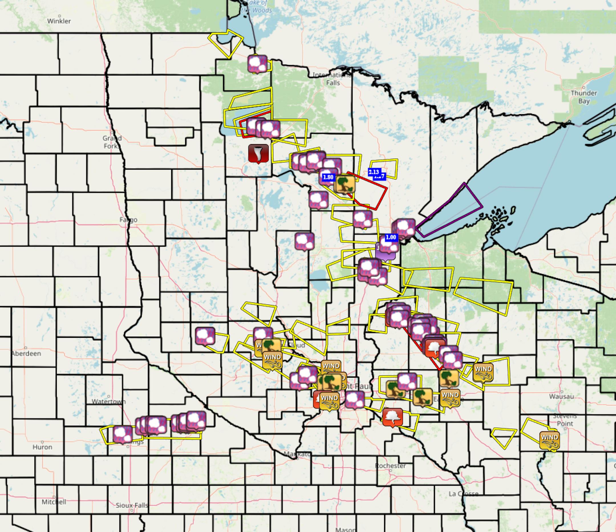
Numerous Severe Thunderstorm Warnings and even a few Tornado Warnings were issued across Minnesota into western Wisconsin due to severe storms Wednesday afternoon and evening. The top wind report from the state was 74 mph near Richmond. The largest hail reported was in Marcell (up in northern Minnesota) where it was measured at 2.75" in diameter - the size of baseballs.

_______________________________________________

Pockets Of Extreme Drought

(The Minnesota Star Tribune)

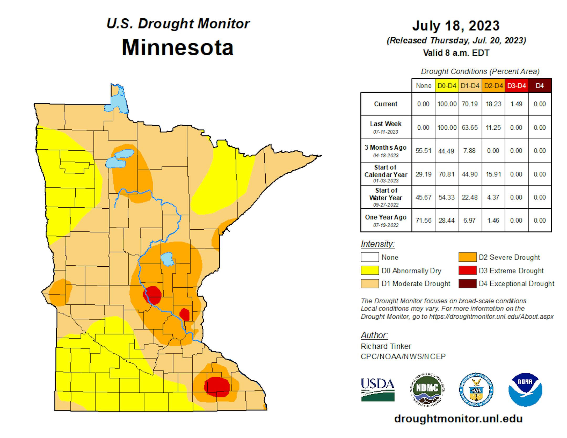
The latest Drought Monitor was released on Thursday, and the big story in this week's update was the introduction of three small areas of D3 (of 4) Extreme Drought, totaling 1.49% of the state. These three areas were centered around St. Cloud, the north metro (Andover and Ham Lake areas), and Rochester. We also saw new pockets of D2 Severe Drought in western and northern Minnesota, with an expansion of the area that was in place in eastern Minnesota.

(The Minnesota Star Tribune)

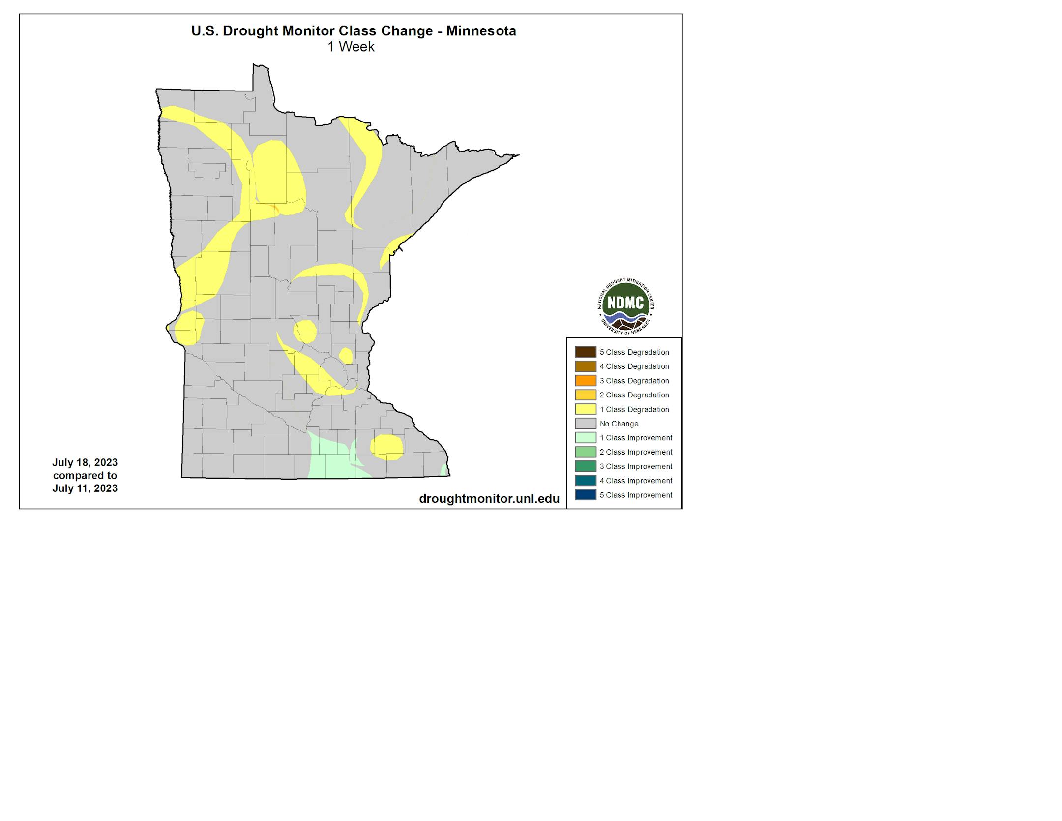
Some slight improvement did occur over the past week in south-central Minnesota - otherwise, we only saw the drought stay steady or worsen. Note that this does NOT include the rain that fell Wednesday evening across the region - that'll factor into next week's Drought Monitor.

_______________________________________________

Mainly Sunny Friday

(The Minnesota Star Tribune)

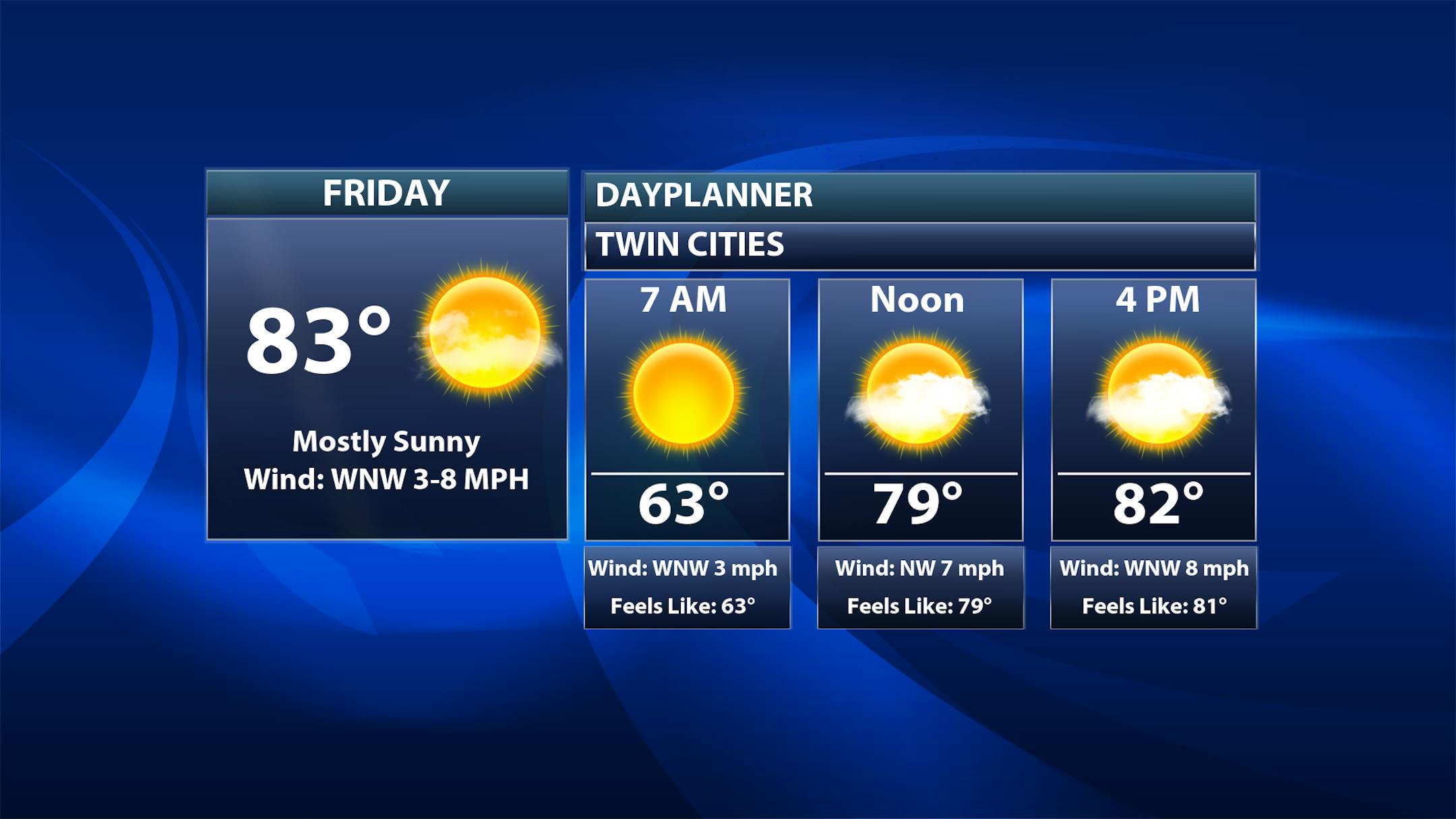
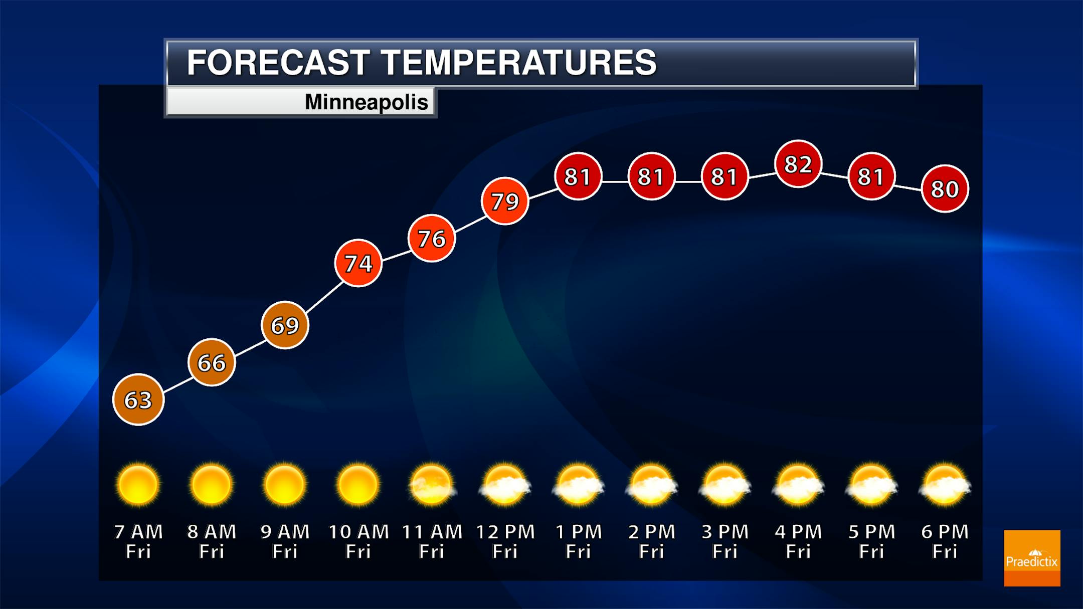
A mix of sun and clouds to mainly sunny skies are expected Friday in the metro. I can't rule out an isolated afternoon shower or storm, though chances are a touch better the farther north you go. Morning temperatures will start off in the low 60s with highs in the low 80s.

(The Minnesota Star Tribune)

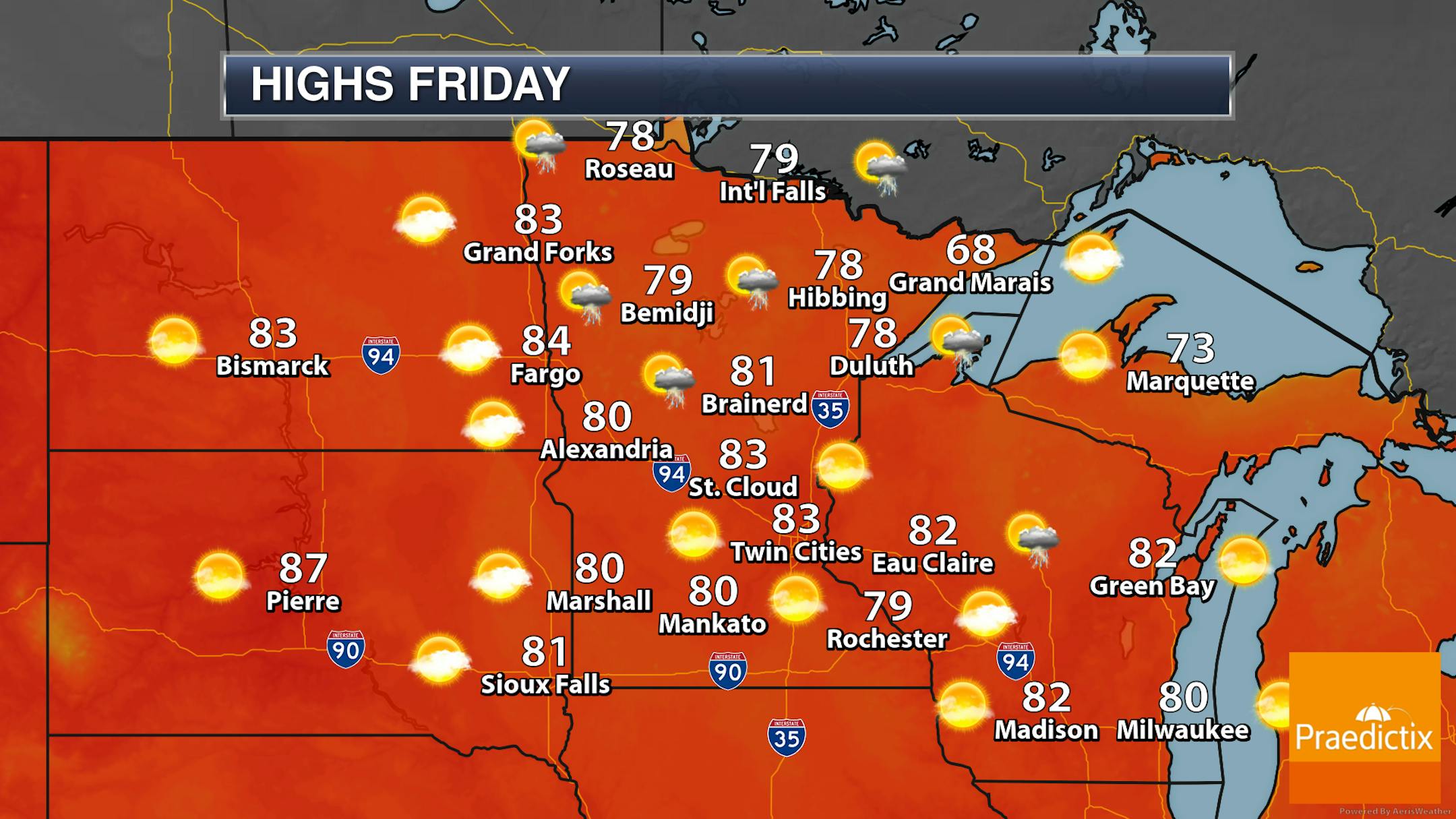
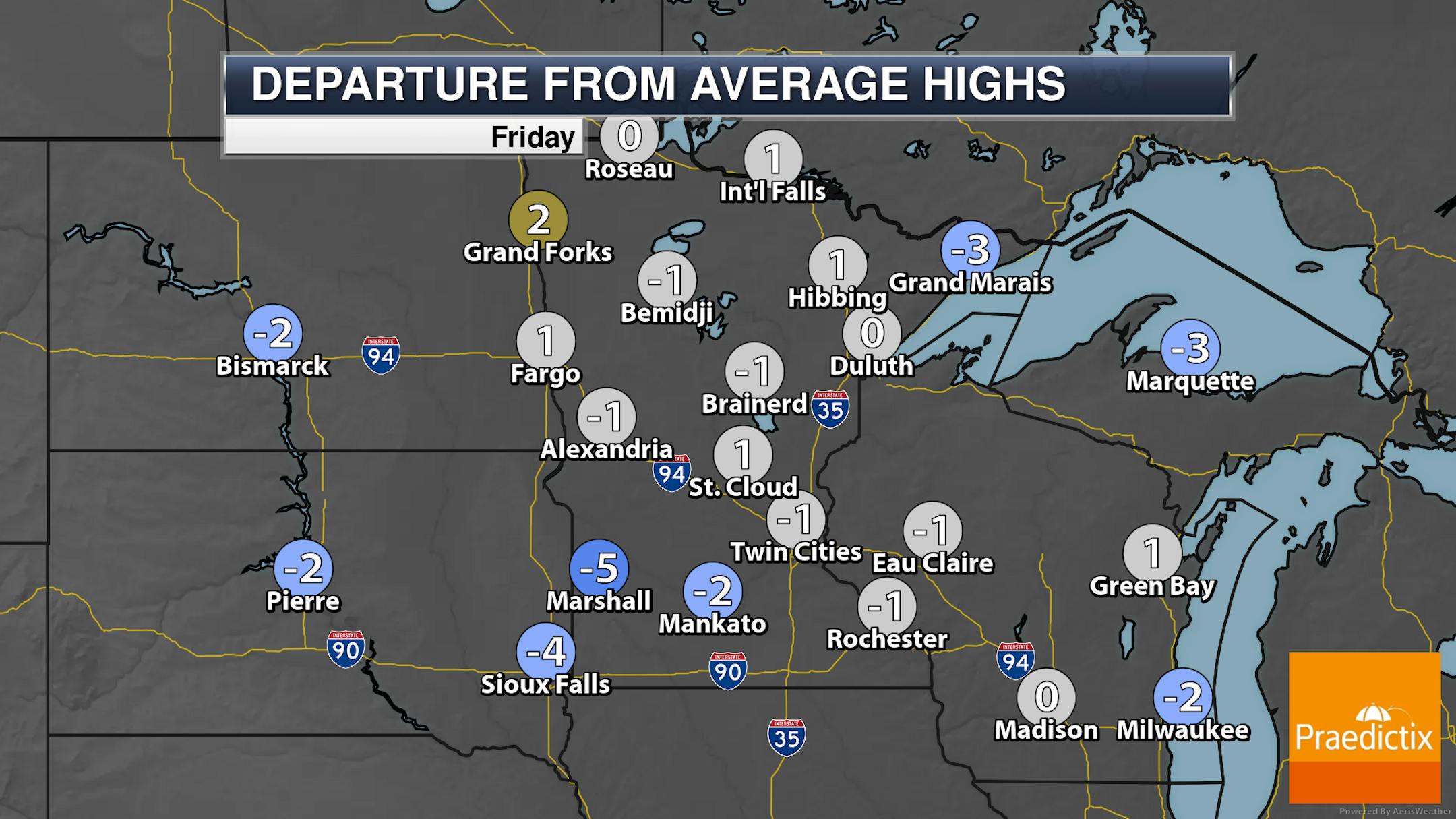
As a weak upper-level wave moves in on Friday, a few afternoon/evening showers or storms can't be ruled out, mainly across northern Minnesota. Most other locations will see a mix of sun and clouds, with some slight wildfire haze in the upper atmosphere. Highs will range from around 70F along the North Shore to the low/mid-80s in the southern half of the state as well as western Minnesota.

_______________________________________________

Weekend Warming - Storm Chance Saturday

(The Minnesota Star Tribune)

Saturday: As another upper-level wave moves through Saturday, we will watch the potential for a few afternoon and evening storms across the region. A few of the stronger storms could produce gusty winds and small hail. Highs will climb into the mid-80s in the metro.

Sunday: Mainly sunny skies are expected as temperatures take another step upward into the upper 80s.

Monday: The first 90F degree day of an expected stretch of 90s is expected under mainly sunny skies.

_______________________________________________

Upper 90s Possible Next Week

(The Minnesota Star Tribune)

Enjoy these more comfortable days in the next few, as we'll be singing Glenn Frey's "The Heat Is On" next week. While we do climb to the low 90s Monday, mid to upper 90s are expected during the mid-week timeframe next week. The record for Tuesday is 99F, 100F for Wednesday, and 104F for Thursday.

(The Minnesota Star Tribune)

The 6-10 day temperature outlook shows a heat bubble across the central United States as we head through the middle and end of next week.

_______________________________________________

Minnesota's Drought Continues To Expand
By Paul Douglas

We interrupt this severe drought for tennis ball size hail. 2-3" diameter hail shredded trees, broke windows and dented vehicles north of Deer River, Minnesota Wednesday. Peak severe season is May and June, but "hailers" are possible into the autumn months, when ingredients are present.

Traditional "Hail Alley" is the Northern Plains and Rockies, but we get our fair share of icy bombs here in Minnesota. By the way, a tennis ball size hailstone hits the ground at nearly 100 mph. Put on your helmets please.

The entire state is too dry, and moderate drought covers 70% of Minnesota, with severe drought in the metro, and pockets of extreme drought showing up near Anoka, St. Cloud and Rochester. Our weather can turn on a dime, but I doubt we'll see significant rain until fall and winter; possibly not until 2024. I hope I'm wrong.

T-storms bubble up Saturday, otherwise expect sunny, increasingly hot weather into next week.

ECMWF hints at mid to upper 90s by the middle of next week. Something to look forward to.

_______________________________________________

Paul's Extended Twin Cities Forecast

FRIDAY: Warm sunshine. Wake up 63. High 84. Chance of precipitation 10%. Wind NW 7-12 mph.

SATURDAY: Some sun, few T-storms around. Wake up 64. High 86. Chance of precipitation 70%. Wind W 10-20 mph.

SUNDAY: More sunshine, probably dry. Wake up 64. High 88. Chance of precipitation 10%. Wind NW 7-12 mph.

MONDAY: Sunny and hot. Wake up 67. High 91. Chance of precipitation 10%. Wind S 5-10 mph.

TUESDAY: Sweaty sunshine, stray T-storm? Wake up 70. High 92. Chance of precipitation 30%. Wind SE 10-20 mph.

WEDNESDAY: Sizzling sunshine. Wake up 75. High 97. Chance of precipitation 10%. Wind SE 7-12 mph.

THURSDAY: Sunny, feels like 105+. Wake up 77. High 96. Chance of precipitation 10%. Wind NW 7-12 mph.

_______________________________________________

Minneapolis Weather Almanac And Sun Data
July 21st

(The Minnesota Star Tribune)

*Length Of Day: 15 hours, 5 minutes, and 25 seconds
*Daylight LOST Since Yesterday: 1 minute and 55 seconds

*When Do We Drop Below 15 Hours Of Sunlight? July 24th (14 hours, 59 minutes, 22 seconds)
*When Are Sunrises After 6 AM? August 2nd (6:00 AM)
*When Are Sunsets At/Before 8:30 PM? August 8th (8:30 PM)
_______________________________________________

This Day in Weather History
July 21st

2002: Dew points reach 84 degrees at Madison, Morris, and Olivia. This ties the all time highest dew point reading in Minnesota, as recorded by the State Climatology Office.

1934: Extreme heat hits western Minnesota, and the temperature topped out at 113 at Milan.

_______________________________________________

National Weather Forecast

(The Minnesota Star Tribune)

A frontal boundary stretched from the Northeast to the Southern Plains will help spark off showers and storms on Friday. Some storms will also be possible in the Upper Midwest and in southern Florida. The excessive heat continues south of that frontal boundary and in the Southwest.

(The Minnesota Star Tribune)

Heavy rain will be possible through the end of the week into the first half of the weekend across portions of the Front Range, the Tennessee River Valley, and the Northeast. Some of these areas could see over 3" of rain.

_______________________________________________

Biden boosted climate action. But U.S. emissions goals still in doubt.

More from E&E News: "When Joe Biden was a presidential candidate in 2020, he pledged to ban oil and gas drilling on public land, pump federal money into clean energy, and achieve net-zero emissions by midcentury. Three years later, the country's emissions trajectory remains highly uncertain. The United States is within reach of cutting its carbon pollution in half by 2035 — if it's able to install a massive number of renewable energy projects. Or the nation could fall far short of its international climate promises and reduce its emissions by as little as 29 percent in 2030 — if fossil fuel prices remain low, economic growth surges and clean electricity installations stumble, according to a report released Thursday by the Rhodium Group."

This new factory will turn CO2 into sustainable jet fuel

More from Canary Media: "Nearly two years ago, the startup Twelve made its first batch of lower-emissions jet fuel at its lab in Berkeley, California. Using electricity, water and carbon dioxide, the company set out to make a synthetic fuel that could replace fossil-based kerosene and, ideally, reduce the outsize greenhouse gas emissions that come from flying airplanes. Now, Twelve is ramping up to make significantly higher volumes of its ​"E-Jet" fuel. Last week, the eight-year-old startup broke ground on a commercial-scale facility in Moses Lake, Washington, on the site of a former sugar-beet mill. Once up and running by mid-2024, the facility will be the first of its kind in the country to make alternative jet fuel from CO2 and grid power."

Mosquitos are moving to higher elevations — and so is malaria

More from Grist: "As the planet warms, mosquitoes are slowly migrating to higher places — and bringing malaria to populations not used to dealing with the potentially deadly disease. Researchers have documented the insects making their homes in higher places that are typically too cool for them, from the tropical highlands of South America to the mountainous but populous regions of eastern Africa. A recent Georgetown University study found them moving upward in sub-Saharan Africa at the rate of 21 feet per year. "The link between climate change and expansion or change in mosquito distributions is real," said Doug Norris, a specialist in mosquitoes at the Johns Hopkins Bloomberg School of Public Health."

_______________________________________________

Follow me on:

Thanks for checking in and have a great day!

- D.J. Kayser

(The Minnesota Star Tribune)
about the writer

about the writer

D.J. Kayser

See Moreicon

More from No Section (Assign Gallery and Videos here)

See More

The man suspected of killing a Minnesota lawmaker and wounding another crawled to officers in surrender Sunday after they located him in the woods near his home, ending a massive, nearly two-day search that put the entire state on edge.