Advertisement

I'm Happy To Report Little To Report

Expect ideal State Fair strolling weather with low humidity (dewpoints in the 50s - you're welcome) and afternoon highs in the mid-70s today and closer to 80F Sunday. Models suggest a warming trend in time for Labor Day weekend. We haven't seen the last 90s of summer. This is just a 6-day siesta from the muggies. Check the blog for more details. -Todd Nelson

August 26, 2023 at 2:30AM
Advertisement

Minnesota State Fair Weather

"It's time once again for the "Great Minnesota Get Together." Weather plays quite a role in the State Fair experience. Who doesn't remember braving the heat with the crowds on one of the busier intersections on a sweltering afternoon? A quick rain burst will send people scurrying for cover, and folks savor balmy days in the 70s with just a bit of a breeze. Below are some State Fair weather facts and notable weather events that have happened in past Minnesota State Fairs. Quick History of the Minnesota State Fair The Minnesota State Fair has been held at its current site since 1885. Before that it was held at a variety of locations including Fort Snelling. There were some years when the Fair was not held because of war, disease, or for logistical reasons. These years are: 1861 (Civil War), 1862 (Civil and Indian War), 1893 (Columbian Exposition), 1945 (fuel shortage because of WWII), and 1946 (outbreak of Polio.) In 2020 the fair was not held due to COVID 19. Beginning in 1975, the fair has a 12-day run each year ending with Labor Day. Thus since 1975, the Fair begins on a Thursday in August. Before 1975, the Fair was held for shorter durations (eleven days from 1972 to 1974, ten days from 1939 to 1971, eight days from 1919 to 1938 and six days from 1885 to 1918). The 2023 Minnesota State Fair runs from August 24-Sepember 4."

Minnesota State Fair on Friday (@DKayserWX/The Minnesota Star Tribune)

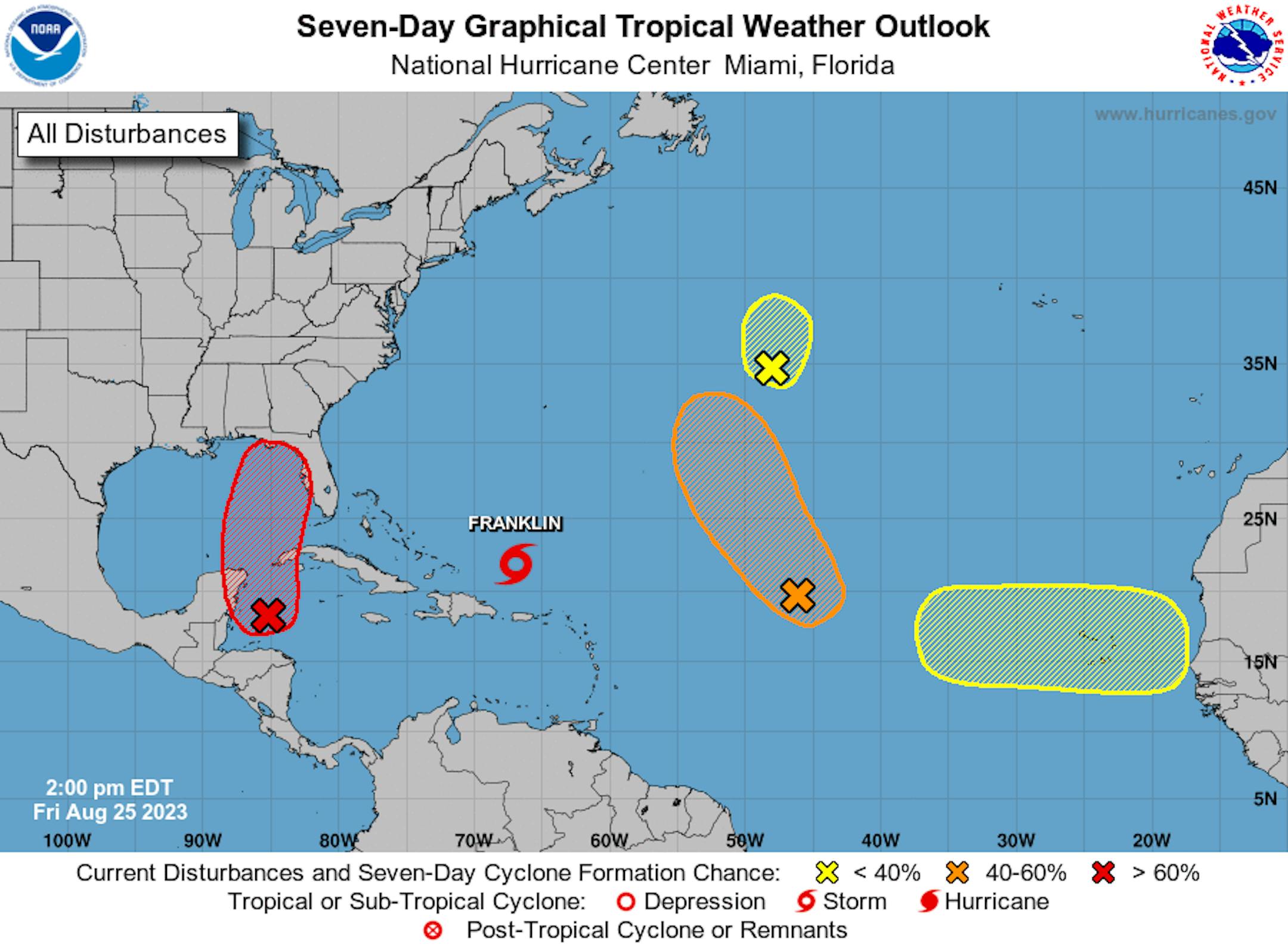
Active Weather in the Atlantic

According to NOAA's NHC, there are several disturbances in the Atlantic basin, including Franklin, which could become a category 2 hurricane by early next week as it makes a close encounter with Bermuda. The other area of interest is the tropical wave drifting north into the Gulf of Mexico. This system has a high likelihood of become a tropical system as we head through the next few days. Some models are projecting this to become a Tropical Storm or even a Hurricane as it approaching the Florida coastline into next week. Stay tuned...

7 Day Atlantic Outlook (NOAA NHC/The Minnesota Star Tribune)

Atlantic Basin Climatology

Our recent uptick in the Atlantic tropical activity coincides with climatology, which suggests that things ramp up pretty quickly during the 2nd half of August and into September. This is when the sea surface temperatures are typically the warmest in the Atlantic Basin. Note that the actual peak of the season is on September 10th, which is less than 3 weeks away. With that being said, the next several weeks could be pretty active in the Tropics.

Atlantic Hurricane & Tropical Storm Climatology (NOAA NHC/The Minnesota Star Tribune)

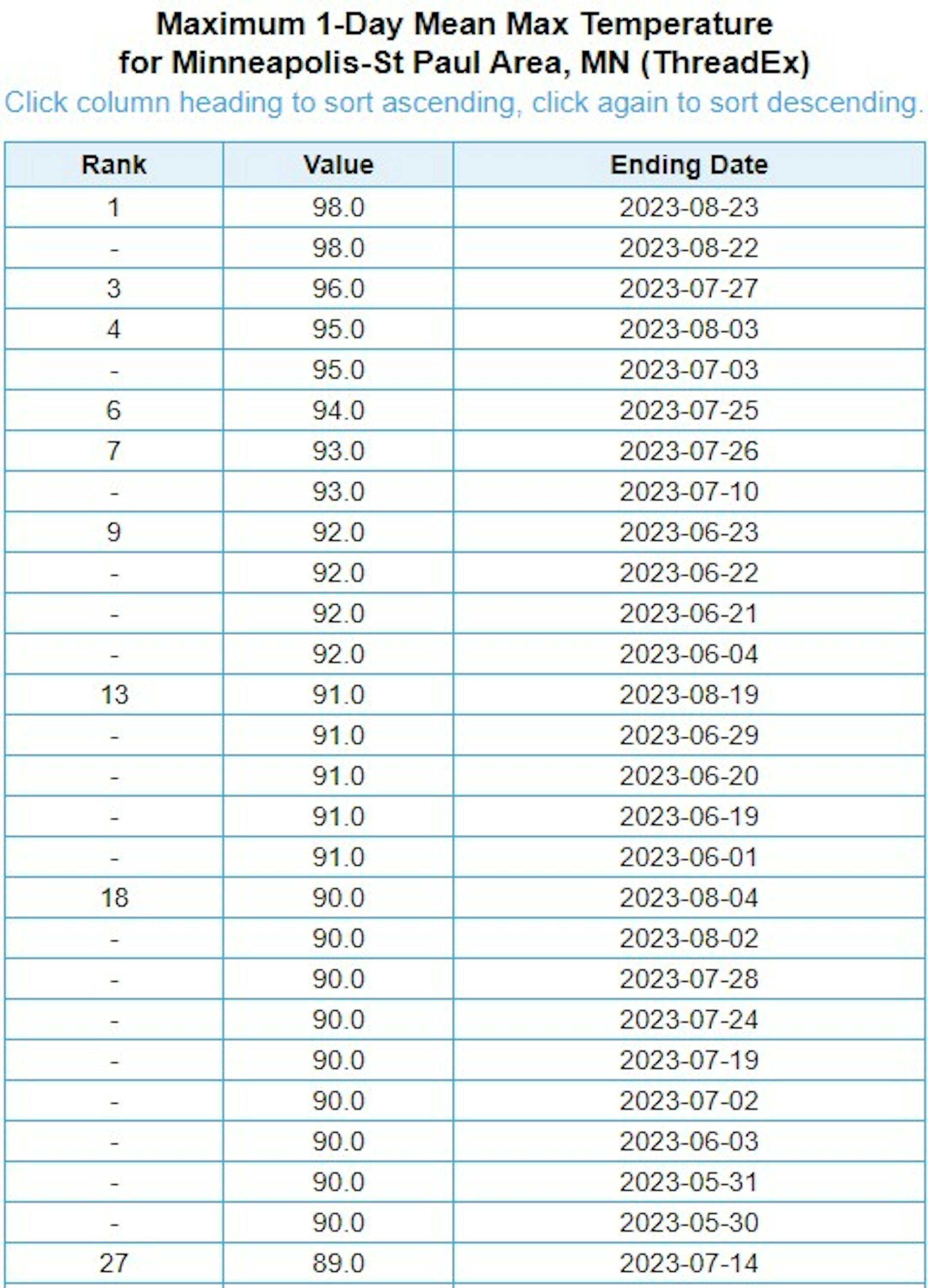
Hottest Days of 2023 So Far

The hottest days of 2023 (so far) were back to back on August 22nd and 23rd, when the MSP hit 98F and heat index values peaking around 110F to 120F around the metro. Uffda! Through Friday, August 25th, there have been (27) 90F days this year and tied for the 13th most number of 90F days in any year.

Hottest Day of 2023 So Far (NOAA NWS/The Minnesota Star Tribune)

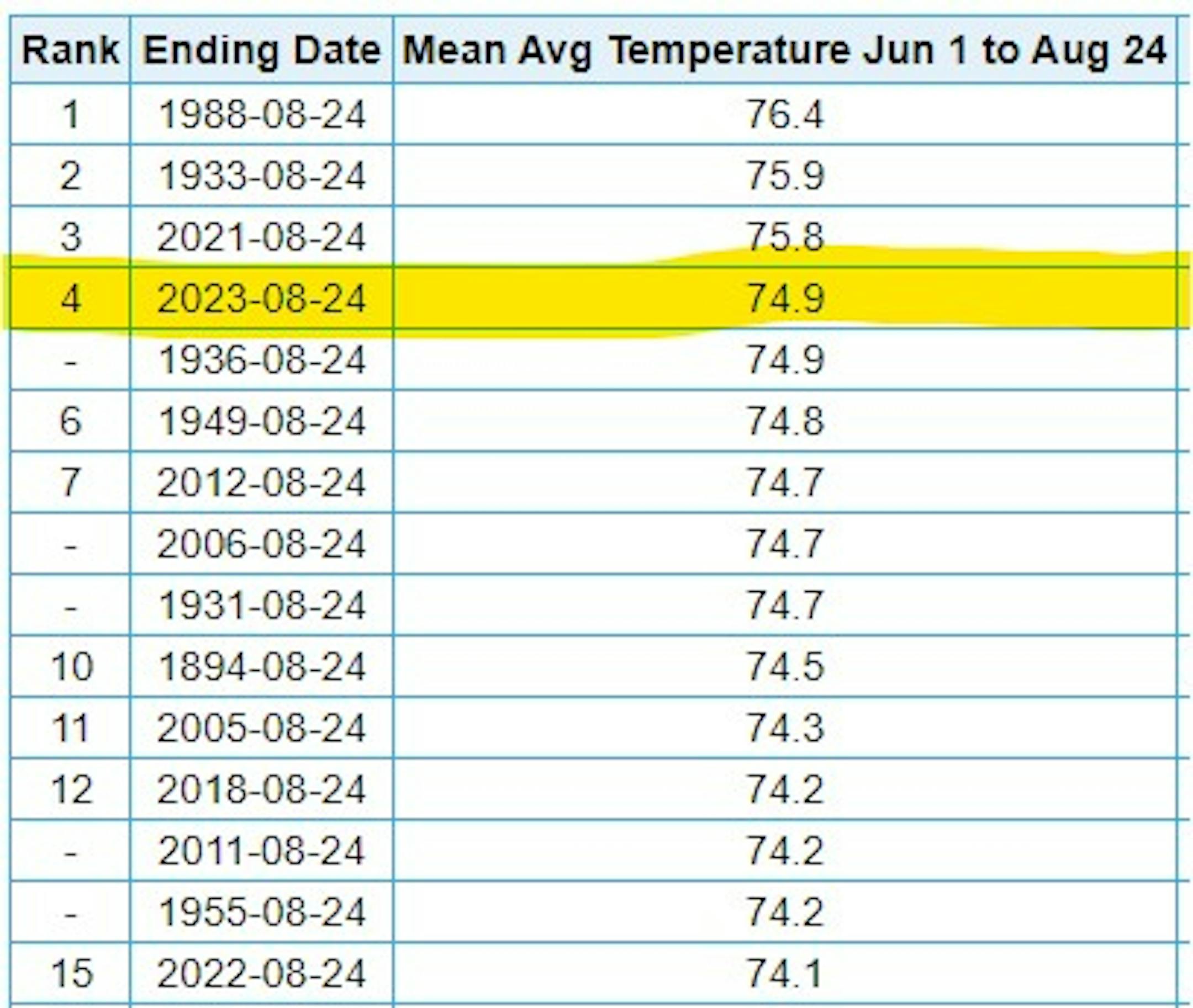
4th Hottest Meteorological Summer on Record

It has also been a hot summer with readings running well above average since June 1st and good enough for the 4th hottest Meteorological Summer on record so far (through August 24thth). Note that 2021 was the 3rd hottest and 2022 was the 15th hottest. Meteorological Summer ends next Thursday.

4th Hottest Summer on Record at MSP (NOAA NWS/The Minnesota Star Tribune)

Average Number of 90F Days At MSP

Looking at the last 30 years, the average number of 90F days at the MSP Airport is (14). July is the hottest month with an average of (6) 90F days. This year we've had (23) 90F days, last year we had (18) days in the 90s and in 2021 there were (27) days in the 90s. The most number of 90F days in any single year was (44) set in 1988.

Average Number of 90F Days At MSP (NOAA NWS/The Minnesota Star Tribune)

11th Driest Meteorological Summer on Record

It has been very dry across much of the region so far this summer with only 5.79" of rain falling at the MSP Airport since June 1st. Interestingly, we're still -6.45" below average this summer. For reference, the driest on record was only 1.73" set in 1894. Interestingly, the summers of 2021 and 2022 were just about as dry as this year has been.

Advertisement
11th Wettest Summer on Record (NOAA NWS/The Minnesota Star Tribune)

90 Day Precipitation Anomaly

On average, the wettest time of the year is in the summer, with the months of June, July and August seeing nearly 13" of rain at the MSP Airport. If we take a look at the 90 day precipitation anomaly, which dates back to about mid May, some locations are nearly -3.00" to nearly -7.00" below average (in red/pink). Note that some locations across southeastern Minnesota are nearly -8.00" to -10.00" below average.

90 Day Precipitation Anomaly (WeatherBell/The Minnesota Star Tribune)

Drought Update

Drought continues across much of the state with a slight uptick in the Severe and Extreme categories. The greatest increase was in the Severe (D3) category, which increase nearly 11% from last week.

MN Drought Update (US Drought Monitor/The Minnesota Star Tribune)

Extended Precipitation Outlook

It is still plenty dry across the state and the extended precipitation forecast doesn't show much in terms of any significant soakings anytime soon. There could be a little here and there over the next 7 days, but not enough to help any of the drought conditions.

Extended Precipitation Outlook (WeatherBell & NOAA's WPC/The Minnesota Star Tribune)

Twin Cities Weather Outlook For Saturday

The weather outlook for the Twin Cities on Saturday, August 26th will be quite a bit cooler than it was over the last several days. Temps will warm into the mid 70s, which will actually be cooler than average for the end of August. Skies will be sunny to start with a few fair weather cumulus clouds developing during the day. Saturday will be a very nice and comfortable day with dewpoints hovering in the mid/upper 50s.

Twin Cities Weather Outlook for Saturday (Praedictix/The Minnesota Star Tribune)
Hourly Dewpoint Forecast For Minneapolis on Saturday (Praedictix/The Minnesota Star Tribune)

Meteograms For Minneapolis

Weather conditions for Minneapolis through the day Saturday will be very comfortable. Temps will start in the low/mid 60s in the morning and top out in the mid 70s in the afternoon with partly cloudy skies. A fresh northeasterly breeze will blow around 15mph through the day.

Hourly Temps & Sky Conditions For Minneapolis on Saturday (Praedictix/The Minnesota Star Tribune)
Hourly Wind Gusts & Direction For Minneapolis on Saturday (Praedictix/The Minnesota Star Tribune)

Weather Outlook For Saturday

Temps on Saturday will be quite a bit cooler on Saturday with highs only warming into the 60s and 70s across the state. These readings will be nearly -5F to -10F below average for this time of the year. Skies will be dry with partly cloudy conditions.

Advertisement
Saturday Weather Outlook (Praedictix/The Minnesota Star Tribune)
Highs From Average on Saturday (Praedictix/The Minnesota Star Tribune)

Extended Temperature Outlook For Minneapolis

The 5 day temperature outlook for Minneapolis looks quite a bit more comfortable than it was this week. Highs will warm into the 70s to near 80F, which will be at and even slightly below average for the end of August.

5 Day Temperature Outlook For Minneapolis (Praedictix/The Minnesota Star Tribune)

More Comfortable Dewpoints.

The 5 day dewpoint forecast for Minneapolis looks quite a bit more comfortable than it was last week. It certainly won't be as sticky/tropical with readings generally holding in the 50s through next week.

5 Day Dewpoint Outlook For Minneaoplis (Praedictix/The Minnesota Star Tribune)

Extended Weather Outlook For Minneapolis

Well that's more like it. The extended temperature forecast won't be nearly as hot as it was this week. Highs will warm into the 70s to near 80F through the middle part of next week with a slight uptick in temps as we approach the early part of September. Weather conditions will also be mostly dry over the next 7 days.

7 Day Weather Outlook For Minneapolis (Praedictix/The Minnesota Star Tribune)

Another Hot Week Shaping Up

According to NOAA's National Blend of Models, we'll have more comfortable conditions through the middle part of next week. However, we're noticing a bump upward as we approach early September. Readings could once again approach the 90F mark.

NBM Extended Temperature Outlook For Minneapolis (WeatherBell/The Minnesota Star Tribune)

Weather Outlook

Weather conditions in the Midwest look fairly quiet over the next several days with minimal precipitation chances through next weekend. The big story will be southeast of us, where a tropical system could develop and impact the Southeastern US with gusty winds and heavy rainfall.

Weather Outlook Through Next Weekend (Tropical Tidbits/The Minnesota Star Tribune)

8 to 14 Day Temperature Outlook

According to NOAA's Climate Prediction Center, the 8 to 14 day temperature outlook shows Warmer than average temperatures across much of the nation as we head through the first week of September. The warmest weather will once again be found in the Southern US, where temps will remain well above average.

Advertisement
8 to 14 Day Temperature Outlook (NOAA CPC/The Minnesota Star Tribune)

8 to 14 Day Precipitation Outlook

According to NOAA's Climate Prediction Center, the Northwestern US looks a little more unsettled, while drier weather will settle in across the Central and Southern US.

8 to 14 Day Precipitation Outlook (NOAA CPC/The Minnesota Star Tribune)

I'm Happy To Report Little To Report
By Paul Douglas

Paul, there's no dang-blasted weather to speak of, so would you mind filling in on traffic and maybe update a few sports scores while you're at it? Be a team player. We live in the Super Bowl of Weather, and Minnesota meteorologists rarely get bored, but I'm pleased to report an extended spell of quiet weather into next week. Picture this: temperatures close to normal, no angry blobs on Doppler, no watches, warnings or advisories. One more opportunity to share my favorite chocolate chip cookie recipes with kind readers?

Expect ideal State Fair strolling weather with low humidity (dewpoints in the 50s - you're welcome) and afternoon highs in the mid-70s today and closer to 80F Sunday. Average weather for late August. I'm shocked.

And no, it won't last. Models suggest a warming trend in time for Labor Day weekend. We haven't seen the last 90s of summer. This is just a 6-day siesta from the muggies.

A tropical storm or hurricane may hit Florida by the middle of next week. No storms with names here.

Extended Forecast

SATURDAY: Partly sunny, fresh breeze. Winds: NE 10-20. High: 75.

Advertisement

SATURDAY NIGHT: Mostly clear and cooler. Winds: ENE 5-10. Low: 59.

SUNDAY: Generous sunshine, low humidity. Winds: S 8-13. High: 80.

MONDAY: More clouds, late thunder? Winds: W 8-13. Wake-up: 62. High: 79.

TUESDAY: Peeks of sun, hints of autumn. Winds: NW 10-15. Wake-up: 59. High: 76.

WEDNESDAY: Plenty of sunshine, fair-worthy. Winds: SE 5-10. Wake-up: 58. High 80.

THURSDAY: Sunny with a warm wind. Winds: S 15-25. Wake-up: 60. High 85.

FRIDAY: Sunny and hot again. Winds: SW 8-13. Wake-up: 67. High 90.

This Day in Weather History

August 26th

1915: Unseasonably cold air leads to killing frosts across Minnesota, with a low of 23 degrees at Roseau.

Average High/Low for Minneapolis

August 26th

Average High: 79F (Record: 97F set in 2013)

Average Low: 61F (Record: 44F set in 1964 & 1968)

Record Rainfall: 2.04" set in 2005

Record Snowfall: NONE

Twin Cities Almanac For August 26th (Praedictix/The Minnesota Star Tribune)

Sunrise/Sunset Times for Minneapolis

August 26th

Sunrise: 6:28am

Sunset: 8:01pm

Hours of Daylight: ~13 hours & 33 minutes

Daylight LOST since yesterday: 2 Minutes & 56 Seconds

Daylight LOST since Summer Solstice (June 21st): ~ 2 Hour & 4 Minutes

Moon Phase for August 26th at Midnight

2.9 days Since First Quarter moon

Moon Phase For August 26th at Midnight (The Minnesota Star Tribune)

National High Temps on Saturday

Temperatures on Saturday will be extremely hot across the Southern US with highs running nearly +5F to +15F above average. Widespread records will be found the Gulf Coast States this weekend before slightly cooler air moves in around midweek next week. Cooler weather will settle in across the Midwest with readings at or slightly below average for a change.

National Weather Outlook For Saturday (Praedictix/The Minnesota Star Tribune)
National Highs From Average on Saturday (Praedictix/The Minnesota Star Tribune)

National Weather Saturday

The weather outlook on Saturday will be a little unsettled across the Central US along a boundary that will separate the extreme heat in the Southern US from the more comfortable air mass farther north. Along this boundary, scattered showers and storms will be possible, some of which could be strong to severe with locally heavy rainfall.

National Weather Map For Saturday (Praedictix/The Minnesota Star Tribune)

National Weather Outlook

The weather outlook through Sunday looks a little unsettled across parts of the Central and Southern US. Some of the storms could be a little on the strong side with locally heavy rains.

National Weather Outlook Through Sunday (NOAA WPC/The Minnesota Star Tribune)

Extended Precipitation Outlook

The extended precipitation outlook shows areas of heavy rainfall across the southeastern US with a potential tropical system developing through early next week.

Extended Precipitation Outlook (NOAA WPC/The Minnesota Star Tribune)

Climate Stories

(NOAA/The Minnesota Star Tribune)

"EXPERTS SOUND ALARM AFTER MOUNTAIN COLLAPSES WITHOUT WARNING: 'THE GROUND SURFACE … CAN MOVE, OFTEN VERY QUICKLY'"

"The sky may not be falling, but some mountains are. Insider has reported that the effects of the human-caused overheating of our planet are threatening to make molehills out of mountains. What happened? On June 11, the summit of Mt. Fluchthorn, which sits among the tallest group of mountains in Switzerland, collapsed without warning, sending 3.5 million cubic feet of rock tumbling into the valley below. Thankfully, no people were harmed, but the ordeal left Mt. Fluchthorn 60 feet shorter. The reason for the collapse was a loss of the mountain's permafrost. This permanent layer of ice and dirt exists on many tall mountains in the far north."

"Rare 'blue supermoon' — the biggest and brightest full moon of the year — rises Aug. 30"

"The closest, brightest full moon of 2023 is also the second full moon in August. Here's how to see it. The biggest and brightest full moon of 2023 will rise on Aug. 30, and its strange name deserves an explanation. Called a "blue supermoon," it is the result of three lunar phenomena happening at once. The "blue" supermoon's name has nothing to do with the moon's color. In fact, it will actually be orange. The blue supermoon gets the first part of its name for a different reason: It's the second full moon in August. There are two types of blue moon. The August blue supermoon falls into the first category: two full moons occurring in the same month. That's occasionally inevitable; a new full moon rises every 29.5 days. Given that the Sturgeon Moon occurred on Aug. 1, 2023, the Aug. 30 full moon will be a blue moon. Blue moons of this type, called "calendar blue moons," occur roughly every two or three years, with the next one occurring on May 31, 2026, according to timeanddate."

"5 Reasons I'm Convinced We Can Stop Climate Change"

"Doing right by the planet can make you happier, healthier, and—yes—wealthier. Outside's Head of Sustainability, Kristin Hostetter, explores small lifestyle tweaks that can make a big impact. Write to her at climateneutral-ish@outsideinc.com. When my boys were little, we watched Disney Pixar's Finding Nemo so many times that the three of us could recite nearly every line in the film. I haven't watched it in almost 15 years, but the mantra of everyone's favorite character, Dory, still sticks with me: just keep swimming. That's precisely what I tell myself everyday when I start to stress out about how we're going to stop climate change before it's too late."

Thanks for checking in and don't forget to follow me on Twitter @TNelsonWX

@TNelsonWX (The Minnesota Star Tribune)
about the writer

about the writer

Todd Nelson

See Moreicon
Advertisement