Dry With Warming Temps Into The Weekend

Dry weather continues for the next several days with a warming trend. 70s are expected Sunday! The good news is that a late weekend/early week system should bring some rain to the state. How much? To be determined, but we'll take anything we can get at this point. - D.J. Kayser

October 18, 2022 at 11:00PM
(The Minnesota Star Tribune)

Still Cool With A Sun/Cloud Mix Wednesday

(The Minnesota Star Tribune)

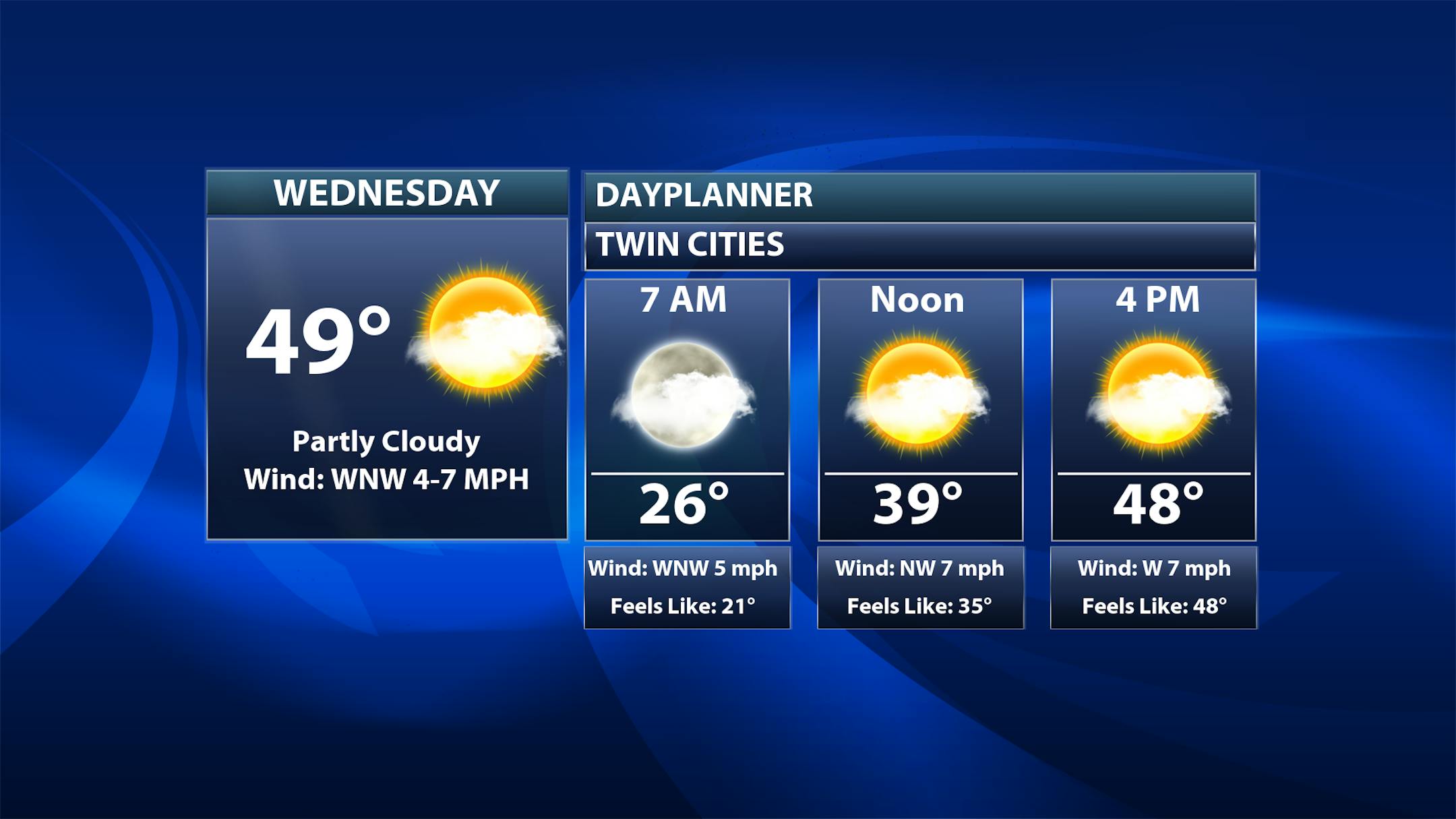
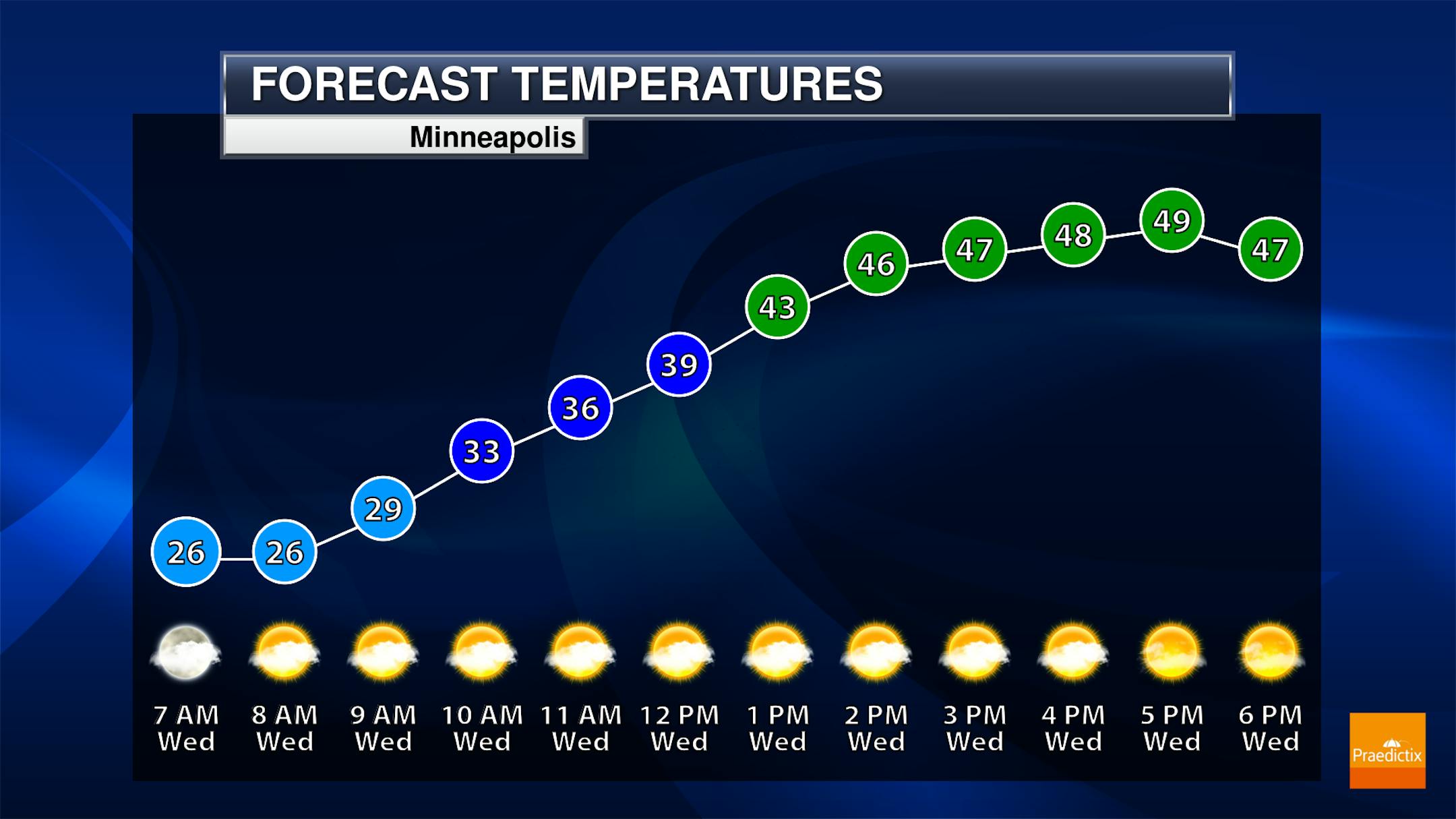
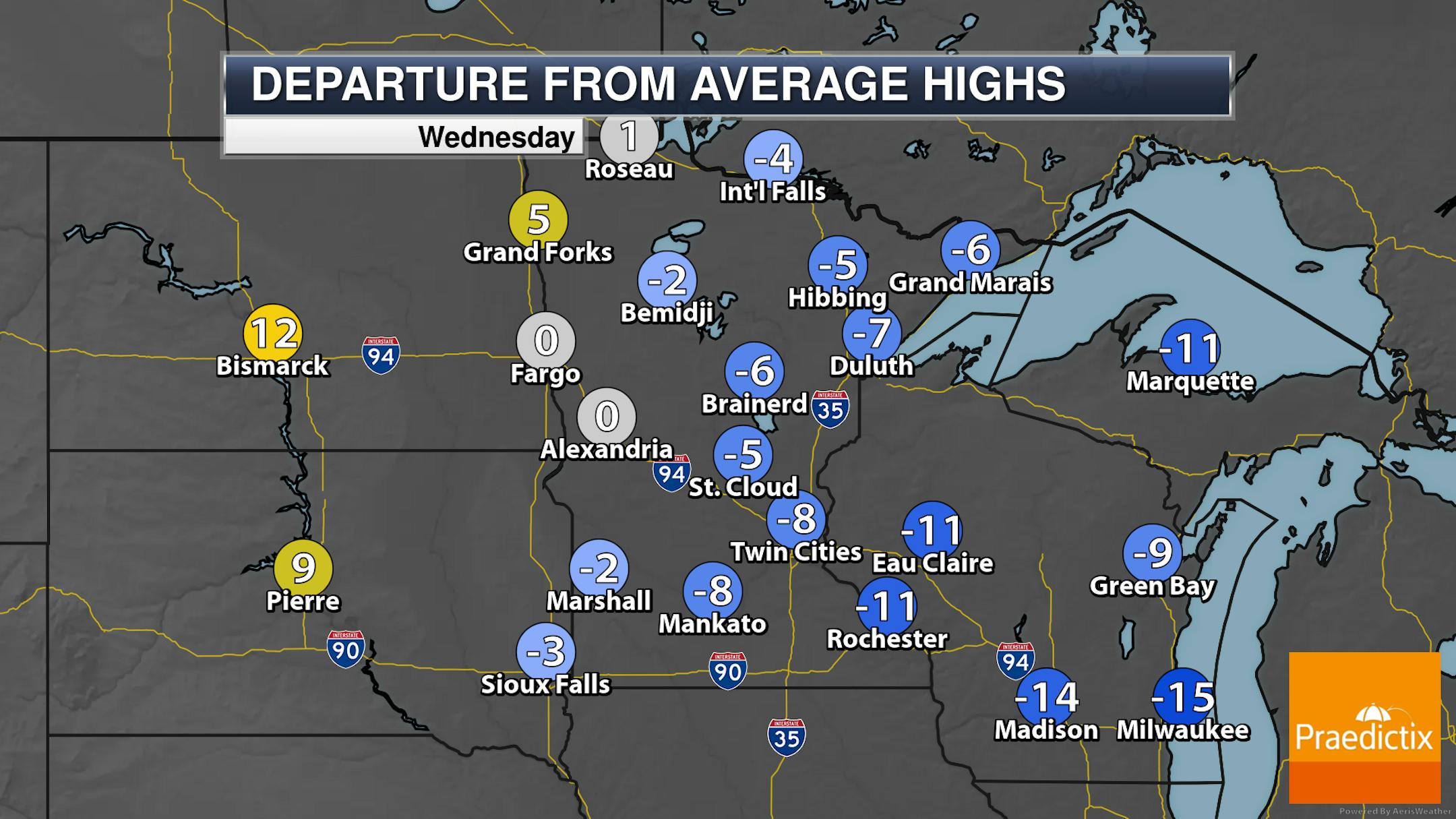
The good news on Wednesday is that we'll be warmer than we were on Tuesday! For those who don't like the chilly air the past few days, that'll at least be of relief to them. However, we'll still start off in the mid/upper 20s with highs only climbing to the upper 40s, which continues to be 5-10F degrees below average.

(The Minnesota Star Tribune)

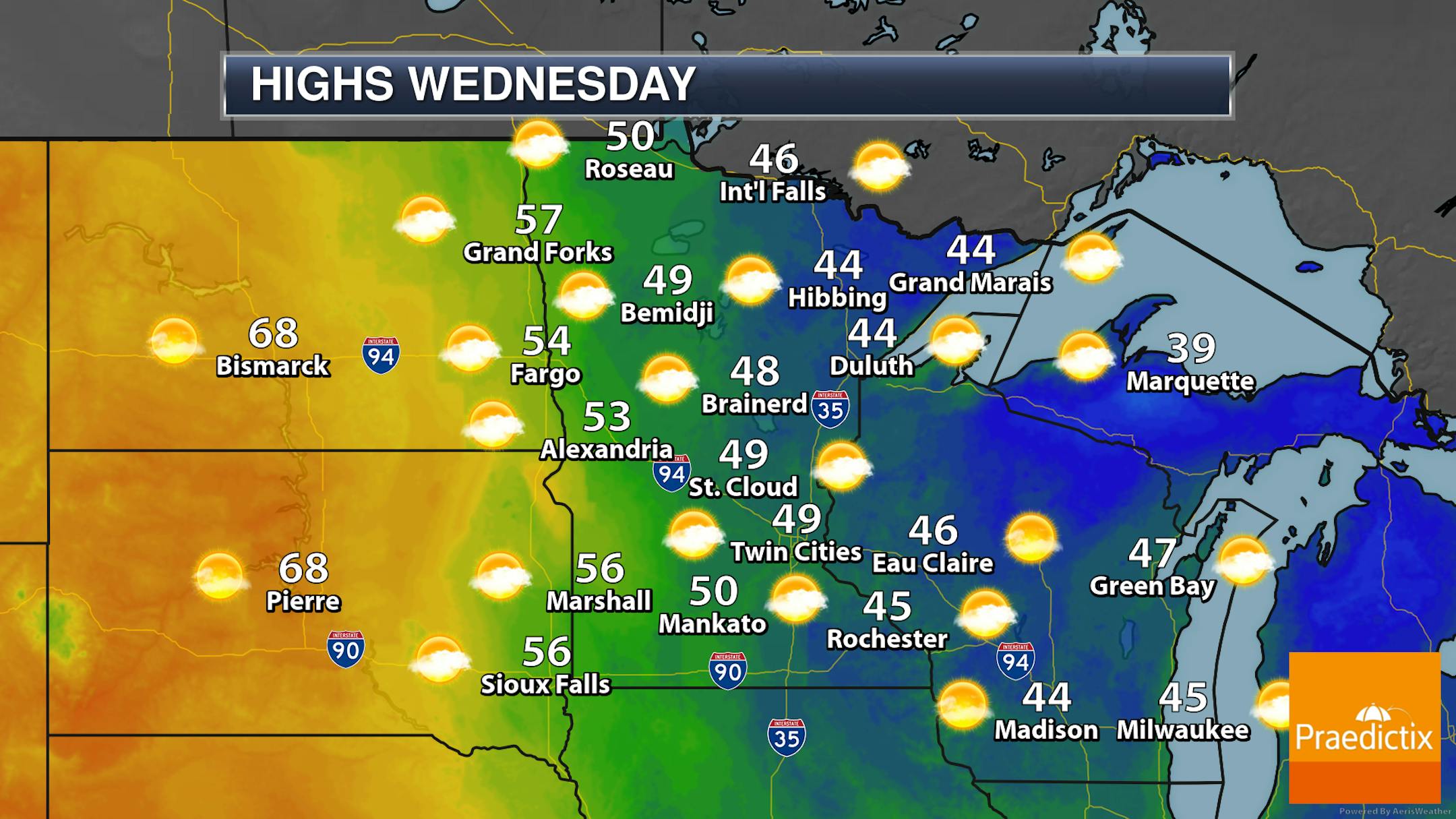
We'll see a little bit of a different temperature gradient across the state Wednesday, with warmer highs (50s) the farther you go west and 40s for eastern Minnesota and western Wisconsin. We'll see a mix of sun and clouds to cloudier skies across the state, but no precipitation is expected.

_______________________________________________

Warming Trend Into The Weekend

(The Minnesota Star Tribune)

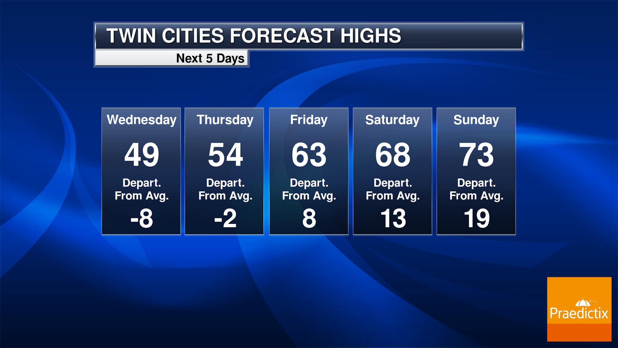
And we'll continue to see warming temperatures right as we head through the rest of the week into the weekend, with 50s for Thursday, 60s for Friday and Saturday, and low/mid-70s as we head into Sunday. And what a turn-around in just over a week the temperatures will be - Monday we saw a high of 40F at MSP, 18F degrees below average... Sunday, we'll be 19F degrees ABOVE average! The only precipitation chance in the next five days comes Sunday evening into the overnight hours - otherwise, a mix of sun and clouds are expected just about every day.

_______________________________________________

Looking Wet Sunday Night Into Monday

(The Minnesota Star Tribune)

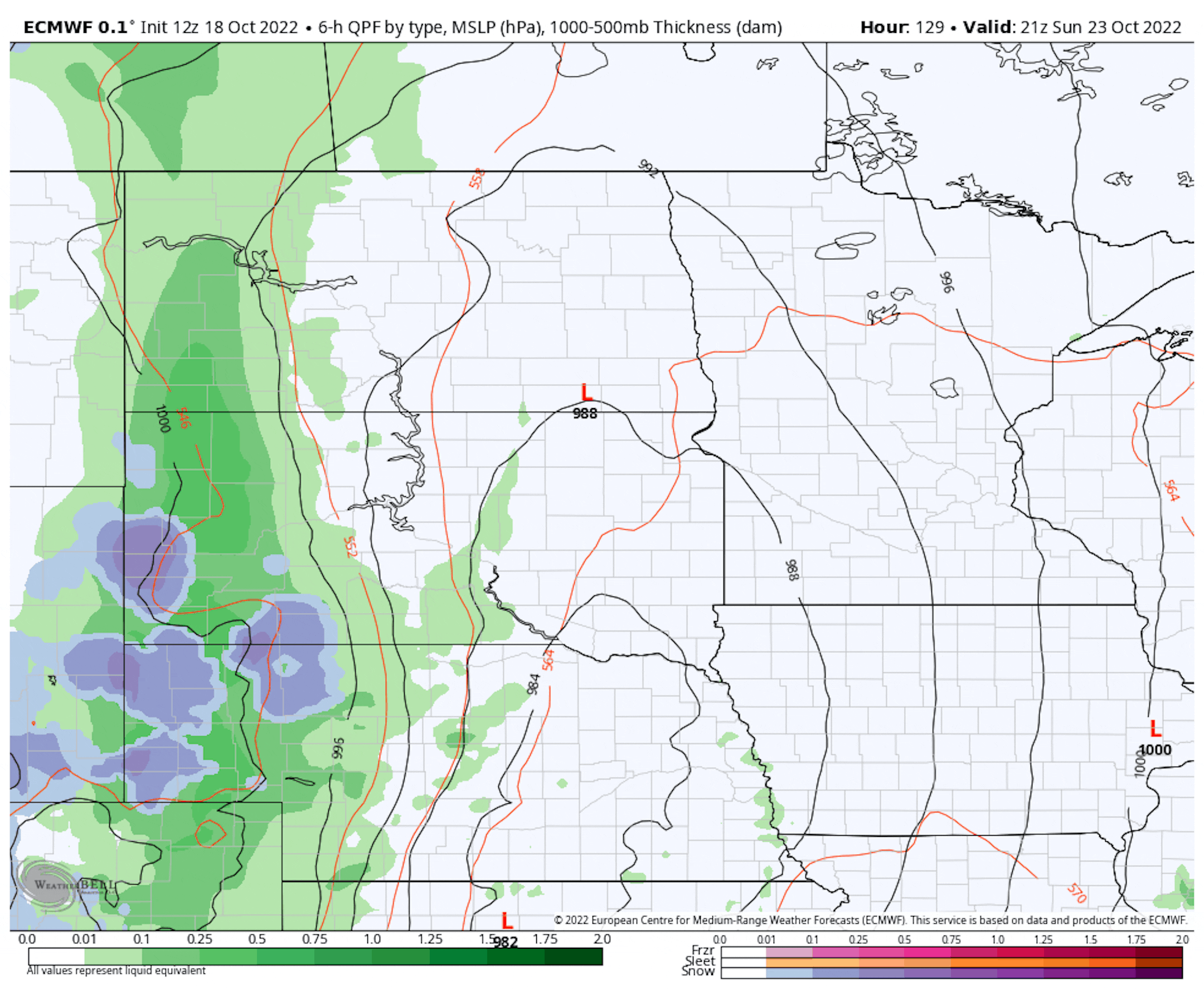
European model output from 4 PM Sunday to 7 AM Tuesday.

Finally, it looks like we'll see our next round of precipitation across the region as we head into the Sunday Night and Monday timeframe with a system moving east. There are still questions as to how strong this system could be and how much rain it'll bring to the region - the European model, shown above, keeps rain across much of the region Monday, meanwhile, the American GFS has most of the Monday limited to northern Minnesota.

(The Minnesota Star Tribune)

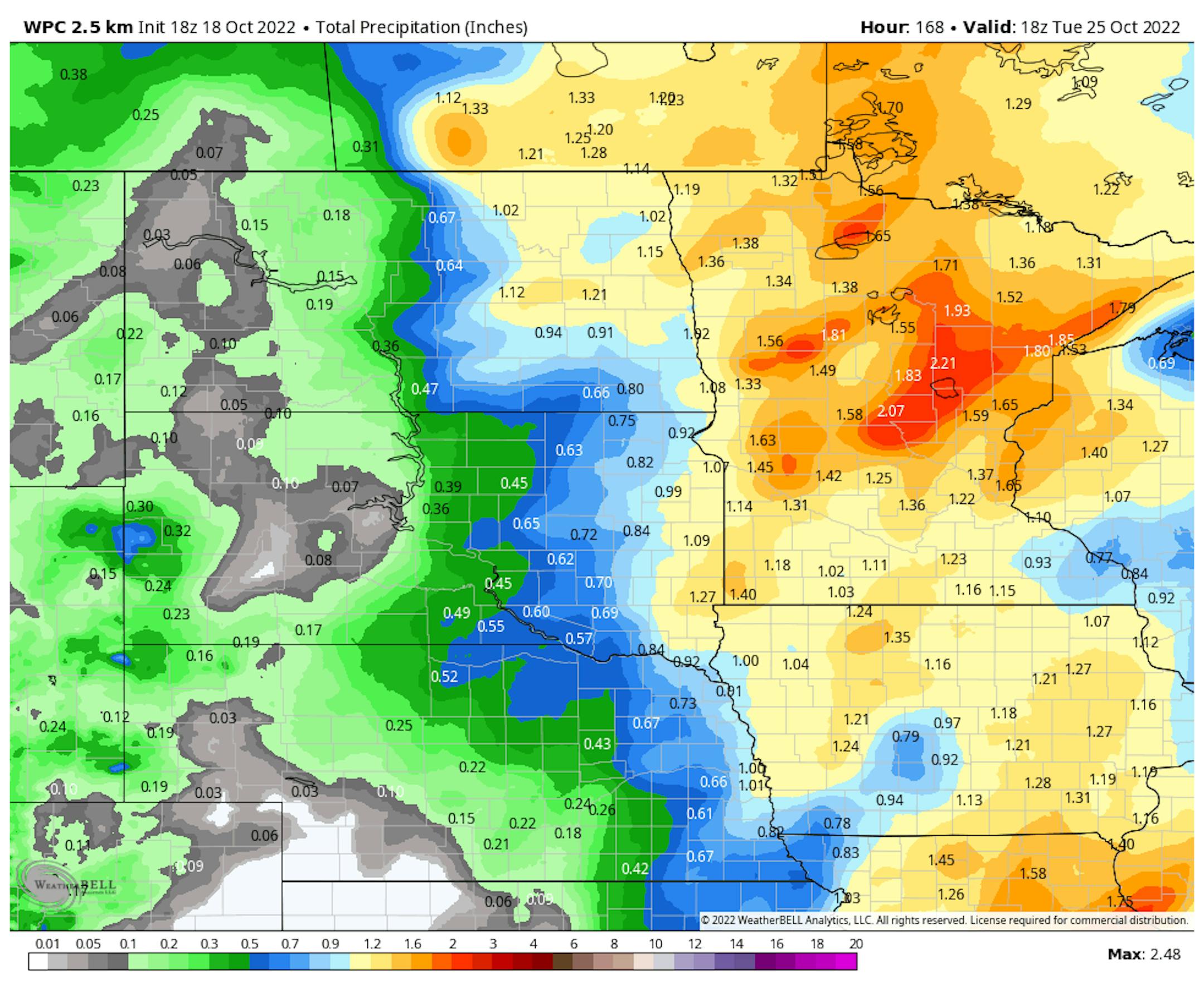
The Weather Prediction Center keeps the rain around much of Monday, and their output has a good 1-2"+ of rain falling late weekend into early next week. Again, we'll keep an eye on this and continue to bring you updates over the next several days!

_______________________________________________

Fall Color Update

(The Minnesota Star Tribune)

As we take a look at the updated fall color map - I don't think I'll be showing this too much longer, unfortunately. A lot of the state is marked as "past peak" now, meaning you and I will be busy raking or mowing those leaves instead of looking at them on the trees! You can keep your eye on this map over the next several weeks from the MN DNR by clicking here.

(The Minnesota Star Tribune)

Here's a handy map of typical peak fall colors from the MN DNR. This ranges from mid/late September in far northern Minnesota to mid-October in southern parts of the state.

_______________________________________________

Dry With Warming Temps Into The Weekend
By D.J. Kayser, filling in for Paul Douglas

Drought continues to plague the state. Personally, I've noticed lots of low ponds and rivers on walks and fall color expeditions across the region. But it's not just us. Almost 82% of the lower 48 is at least abnormally dry, the highest coverage on record. Meanwhile, the Mississippi River at Memphis, TN, hit its lowest recorded stage ever earlier this week at -10.79 feet.

Precipitation helps to tell the story locally. Since September 1st, MSP has picked up only 0.40", the second driest September 1-October 18 on record. Since January 1, we've had 18.67" at MSP - over 9" below average, and the 20th driest year to date on record. This even beats out last year's dry 21.57" to date. The latest Drought Monitor update is released Thursday, and I'm not expecting improvement.

Dry weather continues for the next several days with a warming trend. 70s are expected Sunday!

The good news is that a late weekend/early week system should bring some rain to the state. How much? To be determined, but we'll take anything we can get at this point.

_______________________________________________

D.J.'s Extended Twin Cities Forecast

WEDNESDAY: Sun/cloud mix. Still cool. Wake up 27. High 47. Chance of precipitation 0%. Wind NW 5-10 mph.

THURSDAY: Finally back to average. Peeks of sun. Wake up 36. High 56. Chance of precipitation 0%. Wind NW 5-10 mph.

FRIDAY: More sunshine. A bit windier. Wake up 46. High 63. Chance of precipitation 0%. Wind W 10-15 mph.

SATURDAY: Morning clouds, afternoon sun. Wake up 43. High 69. Chance of precipitation 0%. Wind SE 5-15 mph.

SUNDAY: Breezy & warm. Overnight storms. Wake up 57. High 73. Chance of precipitation 60%. Wind SE 10-25 mph.

MONDAY: Showers likely. Still windy. Wake up 55. High 63. Chance of precipitation 60%. Wind SW 10-20 mph.

TUESDAY: Sunshine and cooler highs return. Wake up 41. High 55. Chance of precipitation 10%. Wind NW 5-10 mph.

_______________________________________________

Minneapolis Weather Almanac And Sun Data
October 19th

(The Minnesota Star Tribune)

*Length Of Day: 10 hours, 47 minutes, and 5 seconds
*Daylight LOST Since Yesterday: 2 minutes and 59 seconds

*When Do We Drop Below 10 Hours Of Daylight?: November 5th (9 hours, 58 minutes, 32 seconds)
*Latest Sunrise Before The Time Change: November 5th (7:57 AM)
*Earliest Sunset Before The Time Change: November 5th (5:55 PM)

_______________________________________________

This Day in Weather History
October 19th

2000: The warmest October 19th in Minnesota history occurs for many towns. Many cities had highs in the 80s, with the Twin Cities hitting 84. Appleton in Swift County reported 90 degrees.

1972: A cold snap moves through Minnesota, with lows of 1 above in Tower and 9 in St. Peter and Luverne.

1916: Redwood Falls receives a record-setting 7 inches of snow.

_______________________________________________

National Weather Forecast

(The Minnesota Star Tribune)

The main story on Wednesday across the nation will be an area of low pressure near the eastern Great Lakes, producing an area of rain and snow showers in the Great Lakes and Northeast. An area of low pressure in New England will also continue to produce heavy rain across parts of Maine. Most of the rest of the nation will be fairly quiet.

(The Minnesota Star Tribune)

The heaviest rain through Thursday evening will be in parts of Maine, where an additional 3"+ could cause flooding concerns.

_______________________________________________

California's 2020 Wildfires Negated Years of Emission Cuts

More from Scientific American: "Carbon pollution from California's 2020 wildfires erased 16 years of the state's greenhouse gas emission cuts, according to a new UCLA study. The fires were the state's most destructive on record, burning 4.2 million acres, killing dozens of people and destroying thousands of homes. The study—published in Environmental Pollution—adds another statistic: the fires released roughly 127 million megatons of greenhouse gas emissions, or about twice California's total emission cuts from 2003 to 2019. "What happened in 2020 was basically like a new sector; a new sector of emissions just came out of nowhere," said study co-author Amir Jina, a University of Chicago professor. The wildfire emissions were "almost as big as their main emission sector, which is transport.""

Flooding Significantly Impacts Food Security, New Study Finds

More from New York University: "New research finds that flooding can affect food security for over 5.6 million people across several African nations. The work comes at a time when floods have also devastated Pakistan, India, and large parts of the European Union and the United States. "Our findings show that floods can impact food security both immediately and in the months after the flood event," says Connor Reed, a former New York University Center for Data Science graduate student and lead author on the study, "The impact of flooding on food security across Africa," which appears in the Proceedings of the National Academy of Sciences. "In many flood events we assessed, there were substantial damages to infrastructure, croplands, and livestock, which compromised food production and access, as well as water resources and sanitation also critical to food security.""

Can Focusing On Climate Change Help Win Elections?

More from FiveThirtyEight: ""Our generation grew up watching as the climate crisis got worse and worse and politicians did nothing." That might sound like a quote from teen climate activist Greta Thunberg, but it's actually the opening line for a new series of political ads appearing in multiple states in the lead-up to the 2022 midterms — ads that the advocacy groups Climate Power Action and the League of Conservation Voters are hoping will tip the scales towards climate-focused Democrats. Historically, however, climate change has not been much of a political kingmaker. Even when candidates trusted that their constituents did care deeply about the environment, it hasn't been something that reliably changed votes. In the 2020 presidential election, for example, two-thirds of voters told exit pollster Edison Research that climate change was a "serious problem" — but 29 percent of that same group voted for then-President Donald Trump, a candidate whose position on climate change was … inconsistent … at best."

_______________________________________________

Thanks for checking in and have a great day! Don't forget to follow me on Twitter (@dkayserwx) and like me on Facebook (Meteorologist D.J. Kayser).

- D.J. Kayser

(The Minnesota Star Tribune)
about the writer

about the writer

D.J. Kayser

See Moreicon