Snowstorm of November 26-27, 2001

"After nearly a month of balmy November weather a powerful, slow-moving winter storm hit Minnesota. A swath of heavy snow fell over central Minnesota. The heaviest snow was centered around Willmar where 21.0 inches fell in a 24-hour period ending at 8am on November 27th. A little snow on the 26th and additional snow after 8am on the 27th brought the total to 30.4 inches. The 21.0 inches was a single day snowfall record for Willmar, but not the state. The state record is 36.0 inches set on January 7, 1994 at Wolf Ridge Environmental Learning Center near Finland. 30.4 inches for Willmar in a single storm event is a lot of snow, but did not break the record for the state or Willmar. The state record remains 46.5 inches also set at Wolf Ridge on January 6-8, 1994. And the Willmar single storm total record remains 30.7 inches from November 29 - December 2, 1985. The storm also brought strong winds to the Duluth Harbor. A peak wind gust of 52 mph was observed at the lift bridge and estimated 10 foot waves were observed. The lake walk along in canal park was damaged by waves and driftwood crashing up on shore. Another interesting phenomena with this storm was that lightning was observed during the falling snow on the evening of November 26th in the Twin Cities. While the storm was severe in parts of the state and brought rush hour to a crawl, it brought needed moisture to most of Minnesota. Winter sports fans also seemed to welcome the winter wonderland scene."

See more from the MN DNR HERE:

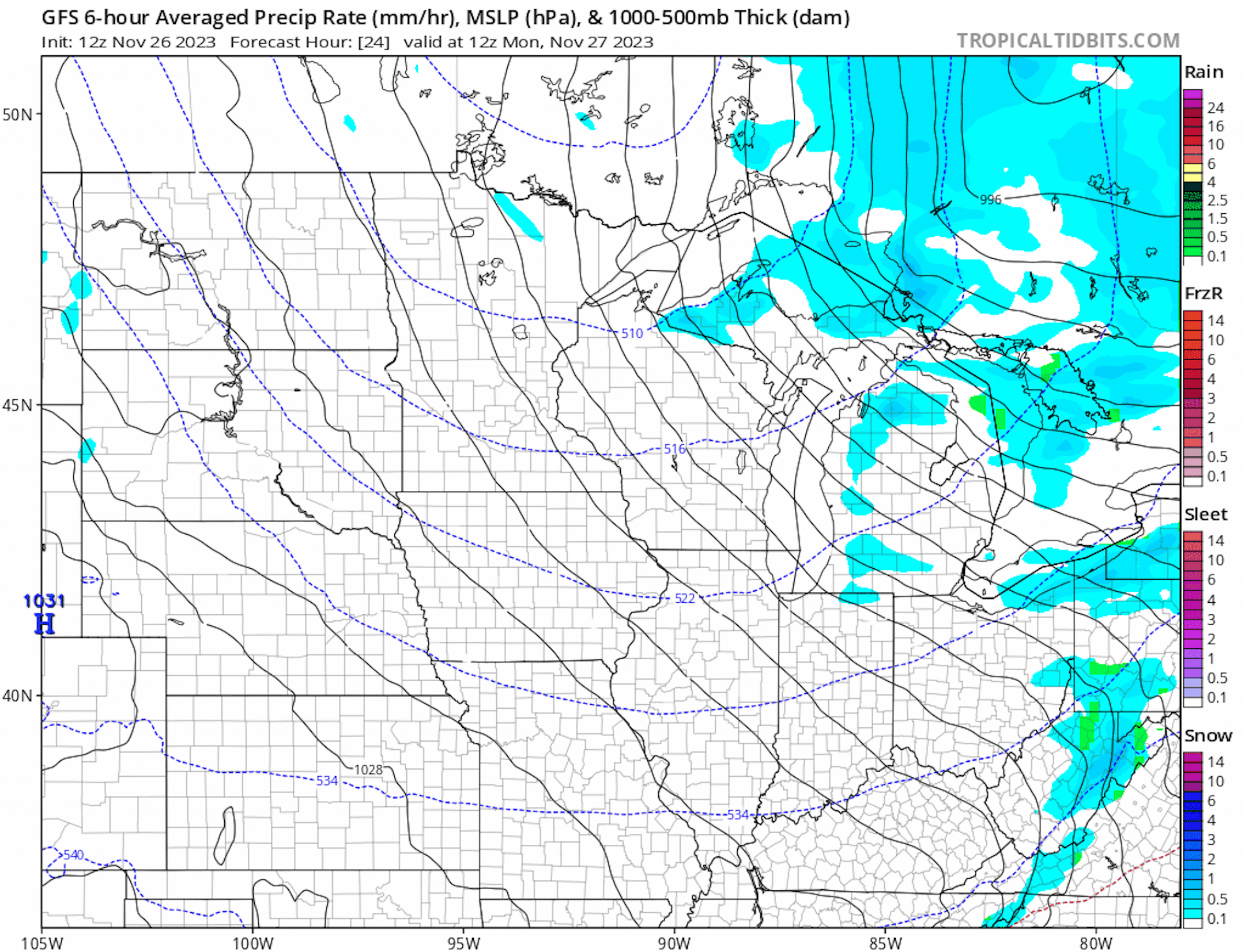
Weather Outlook Through Next Weekend

Here's the weather outlook through next week, which shows mostly quiet conditions region-wide through much of the week. Later in the week, there could be a bigger storm system developing across the Midwest with areas of rain and snow. Stay tuned...

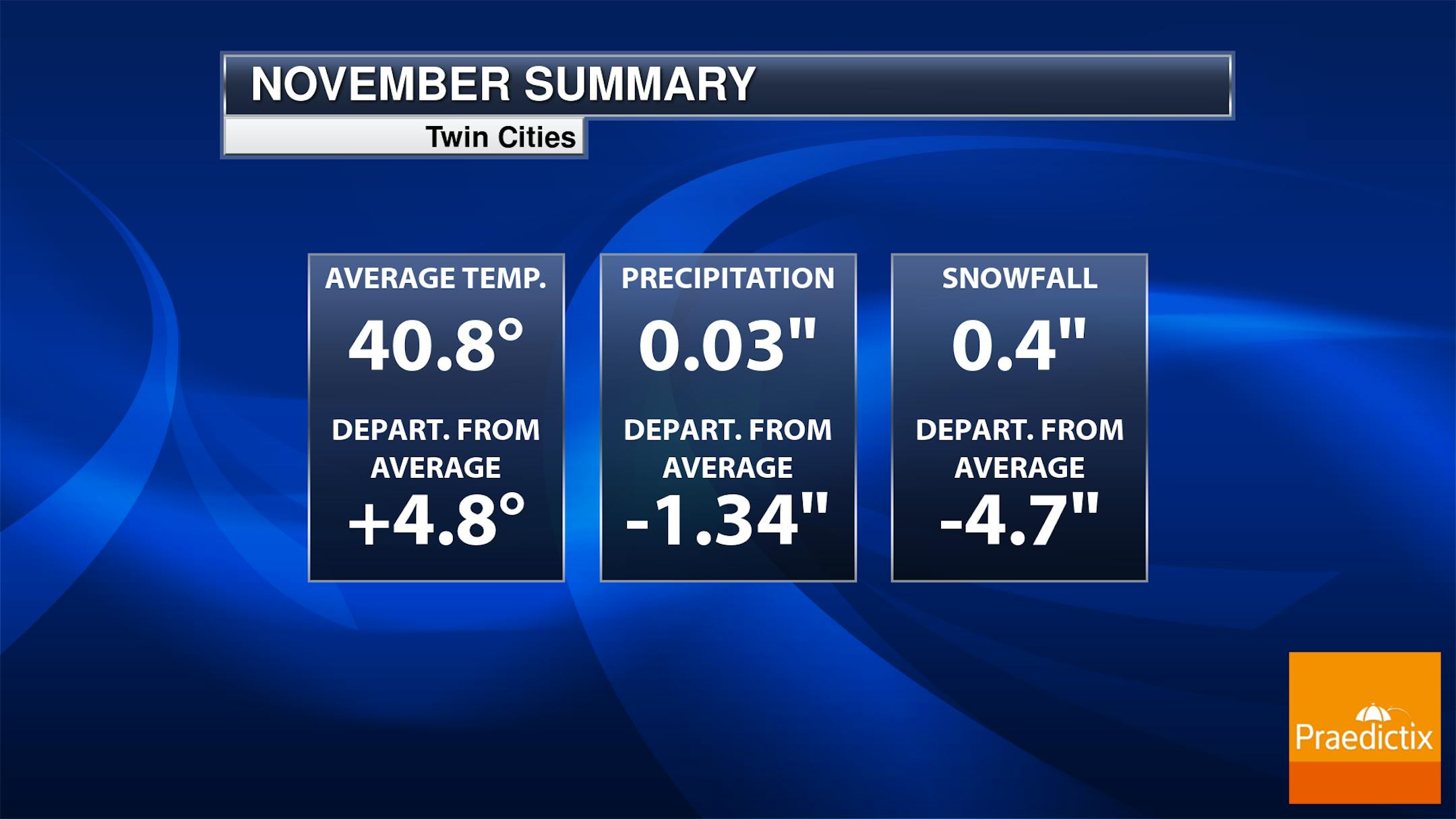
Warmer & Drier Start to November So Far

Despite being chillier as of late, this has been a fairly warm month with the average temperature in the Twin Cities running nearly +4.8F above average, which is the 12th warmest start to any November on record. Precipitation is running nearly -1.34" below average, which is tied for the 3rd start to any November on record. We did manage to pick up close to 0.5" of snow at the MSP Airport Saturday night into Sunday, which is tied for the 16th least snowy November on record.

Twin Cities Average Snowfall

The 30-year average from 1993 to 2022 suggests that we typically see around 5.5" of snow during the month of November. The snowiest month tends to be in December with more than a foot falling. The 2nd snowiest month tends to be January with nearly 11" falling in the metro.
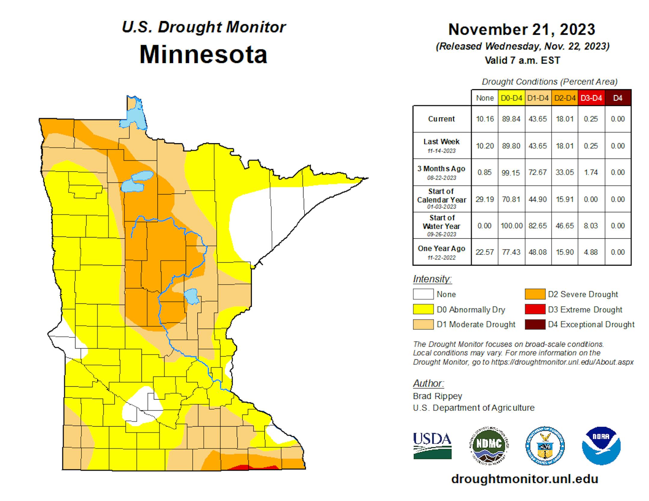
Drought Update

Heavy rains during the month of September have helped the drought situation quite a bit across the state. With that being said, nearly 18% of the state is still in a severe drought, which has improved from 34% nearly 3 months ago.

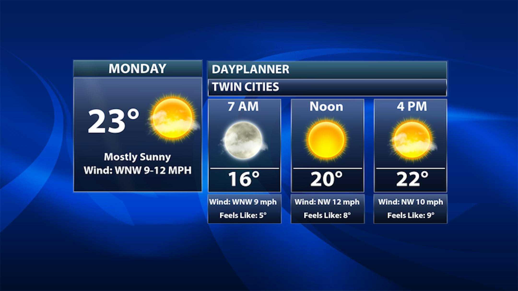
Twin Cities Weather Outlook For Monday

The weather outlook for the Twin Cities on Monday, November 27th will still be chillier than average with temperatures only warming into the low/mid 20s, which will be nearly -10F to -15F below average for this time of the year. Skies will be dry and sunny with a northwesterly wind gusting close to 20mph-25mph, which will make it feel like the single digits all day. Bundle up!

Meteograms For Minneapolis

Temperatures in the Twin Cities will start in the low/mid 20s in the morning and will warm into the lower 30s by the afternoon, which will be nearly -5F below average for this time of the year. There will be a little light snow in the morning with skies turning drier in the afternoon. Winds will turn very breezy in the afternoon with northwesterly winds gusting to 35mph at times.

Hourly Feels Like Temps For Monday

Here are the hourly feels like temps for Minneapolis on Monday. Note that readings will feel like the single digits all day, mainly thanks to a breezy northwesterly wind that will be around 20mph to 25mph.

Weather Outlook For Monday

The weather outlook for Monday will only warm into the 10s and 20s, which will be nearly -10F to -15F below average for this time of the year. Skies will be dry and quiet with strong northwesterly around 20mph to 25mph, which will keep feels like temps in the single digits all day.

Extended Temperature Outlook For Minneapolis

The 5 day temperature outlook for Minneapolis chilly temps lingering through the early week time frame. The coldest day will be Monday with highs only warming into the low/mid 20s. However, we'll warm up nicely as we approach midweek with highs approaching 40F once again, which will be nearly +5F above average for this time of the year.

Extended Weather Outlook For Minneapolis

The extended weather outlook for Minneapolis looks overall pretty quiet. We'll see mostly dry and quiet conditions through the end of the month and the start of December on Friday.

The Extended Outlook Calls For Warmer Temps

According to NOAA's National Blend of Models, it'll be a little chilly to start the week, but we'll warm up nicely with highs approaching the 40F around midweek. The extended forecast keeps highs in the upper 30s through the early part of December.

Weather Outlook

Here's the National weather outlook through the weekend ahead. A larger storm will exit the Northeast early this week with lingering rain and snow and gusty winds. Meanwhile, another storm system will develop in the Southern US later in the week with another round of rain and snow for parts of the Eastern US. As we approach next weekend, we could see another similar storm develop in the Eastern US. Stay tuned...

8 to 14 Day Temperature Outlook

According to NOAA's Climate Prediction Center, the 8 to 14 day temperature outlook shows warmer than average temperatures returning to much of the nation, including the Midwest. The early part of December looks to start on a milder note than what we're seeing now.

8 to 14 Day Precipitation Outlook

The 8 to 14 Day Precipitation Outlook shows more active weather in place the Northwestern and Eastern US. Meanwhile, it looks a little drier across the Southwest and the Central US.

Driving On Snow Is A Winter Artform
By Paul Douglas

Nervous driving on snow? Friends who endure Category 5 hurricanes, debilitating summer heat and ground-shaking earthquakes are scared to death to drive on frozen water.

Experts say to slow down, leave more space, tap the brakes and treat the accelerator pedal like it's made of glass. Chad Sullivan had the best advice on X: "If you rarely drive on snow, just pretend you're taking your grandma to church. There's a platter of biscuits and 2 gallons of sweet tea in glass jars in the back seat. She's wearing a new dress and holding a crock pot full of gravy." What a visual, but helpful.

Grandma is safe for the time being: no big storms in sight into at least mid-December. Another southern system may brush us with a little slush on Saturday night, but the pattern isn't favorable for white-knuckle commutes.

In fact daytime highs may top 40F next weekend - I could see a string of 40s the first week of December.

Symptoms of El Nino? Probably, yes. Less snow than usual this winter? I'm betting on it. Stay tuned.

Extended Forecast

MONDAY: Sunny, coldest day. Winds: NW 10-20. High: 24.

MONDAY NIGHT: Mostly clear and quiet. Winds: NW 5-15. Low: 15.

TUESDAY: Clouds increase, breezy. Winds: S 10-20. High 30.

WEDNESDAY: Plenty of sun, more mellow. Winds: SW 8-13. Wake-up: 27. High 42.

THURSDAY: Sunny, cooling off again. Winds: NW 10-20. Wake-up: 28. High 37.

FRIDAY: Sunny, light winds. Winds: W 5-10. Wake-up: 22. High 34.

SATURDAY: Clouds increase, light snow at night. Winds: SE 10-20. Wake-up: 26. High 38.

SUNDAY: Some sun, any slush melts quickly. Winds: W 8-13. Wake-up: 31. High 41.

This Day in Weather History

November 27th

2005: In the early morning a home in Mower County is hit by lightning and burned to the ground, but no one is injured.

1994: A low pressure system produces the first winter storm of the season for Minnesota. By the early morning hours of the 28th, a swath of snow in excess of 6 inches had blanketed much of southwest through central into northeast Minnesota. Snowfall of 6 inches or more occurred south of a line from Gunflint Lake in Cook County to near Ortonville in Big Stone County, and along and north of a line from near Blue Earth in Faribault County to Red Wing in Goodhue County. The snow closed the Minneapolis-St. Paul International Airport for a short time on the 27th, and contributed to hundreds of accidents and at least three fatalities. In addition, the build-up of ice and snow in combination with strong winds resulted in numerous downed power lines in southeast Minnesota.

1985: Extreme cold hits northern Minnesota. A low of 30 below zero is reported at Crookston.

1971: Heavy snow falls in southwest Minnesota, with Redwood Falls receiving a foot.

Average High/Low for Minneapolis

November 27th

Average High: 36F (Record: 64F set in 1998)

Average Low: 22F (Record: -13F set in 1872)

Record Rainfall: 0.90" set in 1905

Record Snowfall: 7.2" set in 2019

Sunrise/Sunset Times for Minneapolis

November 27th

Sunrise: 7:25am

Sunset: 4:35pm

Hours of Daylight: ~9 hours & 09 minutes

Daylight LOST since yesterday: 1 Minutes & 51 Seconds

Daylight LOST since Summer Solstice (June 21st): ~ 6 Hour & 38 Minutes

Moon Phase for November 26th at Midnight

0.9 Days Until Full "Beaver" Moon

"Nov. 27 at 3:16 a.m. CST - Some accounts suggest the name Beaver Moon came from the fact that this moon signaled it was time to set beaver traps before the swamps freeze to ensure a supply of warm winter furs! Another interpretation suggests that the name Beaver Full Moon comes from the fact that the beavers are now active in their preparation for winter. Also called the Frosty Moon."

National High Temps on Monday

The weather outlook on Monday looks plenty chilly across the nation with readings running nearly -10F to -15F below average. Skies will be mostly dry and quiet in the Central US

National Weather Outlook For Monday

The National Weather Outlook on Monday shows unsettled weather lingering across the Great lakes and the Northeast as a larger storm system moves out of the region. The rest of the nation will be dry and quiet, but it will be chilly.

National Weather Outlook

The National Weather outlook through Tuesday looks quiet across the Central US, but a storm system moving through the Northeast will bring areas of rain and snow to those areas. We'll also see areas of decent lake effect snow, where more than 1ft of snow will be possible in spots.

Extended Precipitation Outlook

The extended precipitation outlook shows heavier precipitation in the Northeastern US through the early week timeframe. There will also be areas of heavier precipitation in the Northwest with high elevation snowfall. Later in the week, another storm will develop in the Southern US with another round of heavier precipitation, which will help with the drought situation there.

Extended Snowfall Outlook

According to the ECMWF weather model, areas of heavy snow in the Rockies and also across the Great lakes and Northeast.

Climate Stories

"Report: Climate change impacts on water are profound and unequal"

"Climate change is intensifying rainfall and floods, deepening droughts, and shifting weather patterns across the globe, threatening terrestrial freshwater supplies and water quality, according to the Fifth National Climate Assessment (NCA5), released Nov. 14. These impacts are unequal, disproportionately affecting the most frontline populations in the United States. "Climate change will manifest through profound changes to the movement, amounts, and timing of water," said CU Boulder's Liz Payton, a water resources specialist in the CIRES-based Western Water Assessment, and lead author of the water chapter. "The water chapter offers a big-picture understanding of the magnitude of these changes and the challenges ahead." Payton worked closely with a team of 11 authors from around the country who brought expertise in climate science, hydrology, groundwater, water management, water quality, and Tribal water issues."

See more from Phys.org HERE:

"4 Reasons To Have Climate Hope For The Holidays"

"Here in Georgia, fall colors are starting to dominate the treescapes. It also signals one of my favorite times of the year—college football, basketball, cooler temperatures and my wife allowing chili and soups on the menu. It is also a transition to peak holiday season, which sparked an online discussion and a suggestion from my friend and colleague Dr. Amanda Townley, who becomes the new executive director of the National Center for Science Education in December: Write about climate hope for the holidays. Challenge accepted. Here are four reasons for hope this holiday season in the midst of headlines about rapidly intensifying hurricanes, sea level rise, flooded cities and drought."

See more from Forbes HERE:

"U.S. and China strike deal on climate ahead of COP28"

The U.S. and China agreed to jointly tackle aspects of human-caused climate change, including the promotion of renewable energy technologies. Why it matters: The agreement marks the next level of bilateral engagement on climate between the world's two biggest emitters. Zoom in: It includes language stating the two countries will "pursue efforts to triple renewable energy capacity globally by 2030," which could ease the adoption of that goal at the upcoming COP28 climate summit in Dubai. Yes, but: The separately issued statements lack a commitment from China to stop approving new coal-fired power plants, a key U.S. concern based on carbon emissions. The intrigue: The countries do touch on power sector emissions, noting that further boosting of renewables would "accelerate the substitution for coal, oil and gas generation," and that the two nations expect "post-peaking meaningful absolute power sector emission reduction" this decade. The U.S. and China agreed to host a "summit" on methane at COP28 and work together to help address this short-lived but potent greenhouse gas. They also committed to addressing greenhouse gases overall, including non-CO2 warming agents like nitrous oxide. What they're saying: "COP28 has its work cut out for it," said Li Shuo, incoming director of China Climate Hub at the Asia Society.

See more from Axios HERE:

Thanks for checking in and don't forget to follow me on Twitter @TNelsonWX