Data Seems To Favor An "Easier Winter"

A clipper arrives today with decorative flurries and winds gusting to 30mph. A week from today: a little rain. An easy winter? Probably easier than most. It would be premature to lower your guard anytime soon. Check the blog for more details. -Todd Nelson

November 26, 2023 at 3:30AM

Weather Outlook Through The Weekend

The weather outlook across the region through early next week shows a quick moving clipper moving through the region with some light snow and breezy winds.

Simulated Radar Through PM Monday (COD Weather/The Minnesota Star Tribune)

Weekend Snowfall Potential

Here's the snowfall potential through the weekend. It doesn't look like much, but some areas could see a light coating and possibly up to 1" in spots. The best potential for accumulations will be in the southeastern part of the state and also across the northern part of the state.

Snowfall Outlook Through The Weekend (WeatherBell/The Minnesota Star Tribune)

Warmer & Drier Start to November So Far

Despite being chillier than average earlier this month, temperatures have been quite a bit warmer than average as of late. That being said, the average temperature in the Twin Cities is nearly +5.1F above average, which is the 12th warmest start to any November on record. Precipitation running nearly -1.30" below average, which is tied for the 3rd start to any November on record. We also haven't had any snow, which currently the least snowy November ever on record.

Twin Cities Climate Data For November (Praedictix/The Minnesota Star Tribune)

Twin Cities Average Snowfall

The 30-year average from 1993 to 2022 suggests that we typically see around 5.5" of snow during the month of November. The snowiest month tends to be in December with more than a foot falling. The 2nd snowiest month tends to be January with nearly 11" falling in the metro.
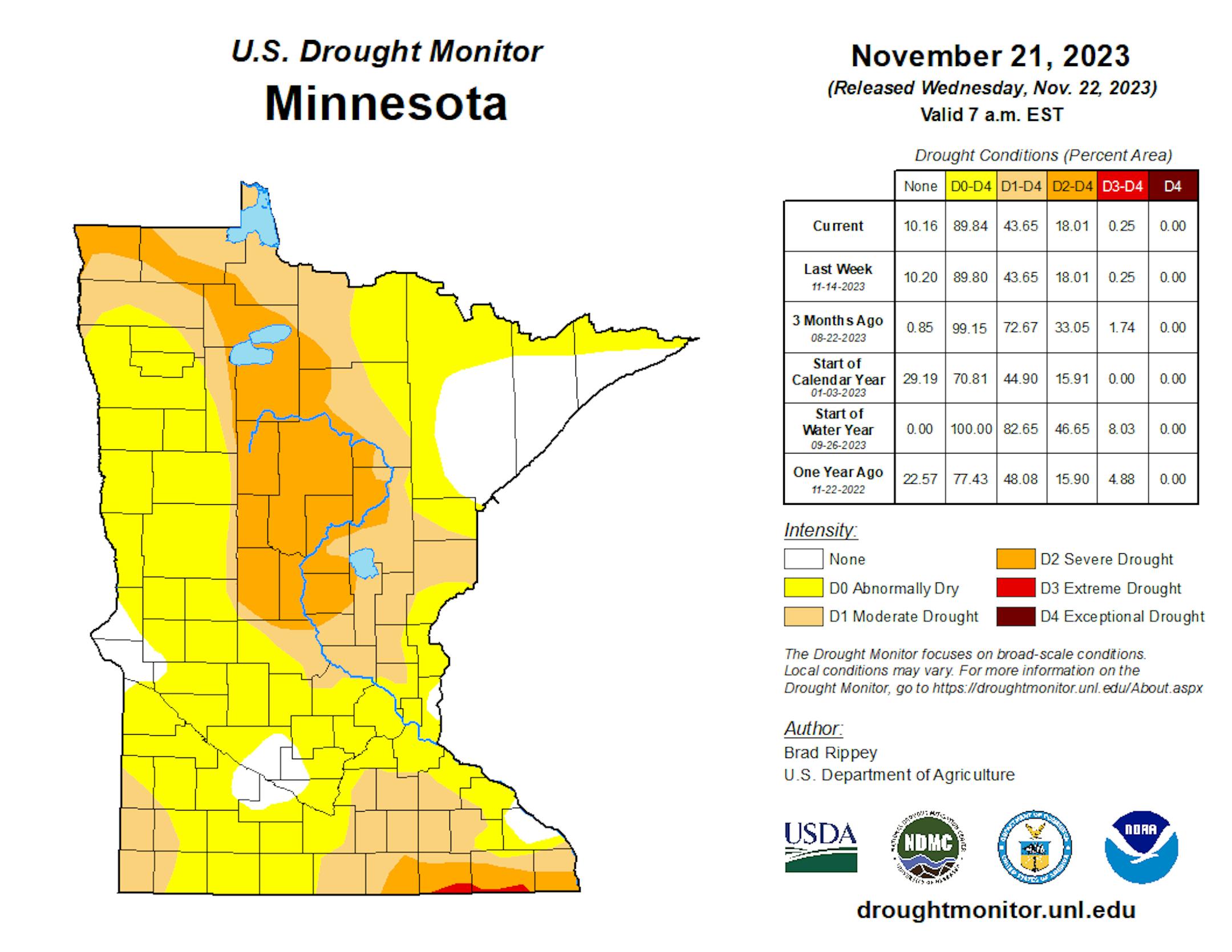
Twin Cities Average Snowfall (Praedictix/The Minnesota Star Tribune)

Drought Update

Heavy rains during the month of September have helped the drought situation quite a bit across the state. With that being said, nearly 18% of the state is still in a severe drought, which has improved from 34% nearly 3 months ago.

Minnesota Drought Update (US Drought Monitor/The Minnesota Star Tribune)

Twin Cities Weather Outlook For Sunday

The weather outlook for the Twin Cities on Sunday, November 26th will be chillier than average by nearly -5F with highs struggling to get to the freezing mark under mostly cloudy skies. Feels like temps will only warm into the 10s and 20s with winds turning more northwesterly.

Twin Cities Weather Outlook For Sunday (Praedictix/The Minnesota Star Tribune)

Meteograms For Minneapolis

Temperatures in the Twin Cities will start in the low/mid 20s in the morning and will warm into the lower 30s by the afternoon, which will be nearly -5F below average for this time of the year. There will be a little light snow in the morning with skies turning drier in the afternoon. Winds will turn very breezy in the afternoon with northwesterly winds gusting to 35mph at times.

Hourly Temperatures & Sky Conditions For Minneapolis For Sunday (Praedictix/The Minnesota Star Tribune)
Hourly Wind Gusts & Direction For Minneapolis on Sunday (Praedictix/The Minnesota Star Tribune)

Weather Outlook For Sunday

The weather outlook for Sunday will warm into the upper 20s and lower 30s across the region, which will generally be below average by around -5F. Skies will be mostly cloudy with a little bit of light snow.

Weather Outlook For Sunday (Praedictix/The Minnesota Star Tribune)
Highs From Average on Sunday (Praedictix/The Minnesota Star Tribune)

Extended Temperature Outlook For Minneapolis

The 5 day temperature outlook for Minneapolis shows above average temperatures running chillier than average through early next week with highs only warming into the upper 20s and lower 30s. As we approach the 2nd half of next week, it looks like we'll see readings gradually warm back to above average levels once agian.

5 Day Temperature Outlook For Minneapolis (Praedictix/The Minnesota Star Tribune)

Extended Weather Outlook For Minneapolis

The extended weather outlook for Minneapolis looks overall pretty quiet. We'll see some light snow on Sunday with temperature running below average through early next week. Highs warm close to 40F again during the middle part of the week, but we'll still be mostly dry and quiet.

7 Day Weather Outlook For Minneapolis (Praedictix/The Minnesota Star Tribune)

The Extended Outlook Calls For Warmer Temps

According to NOAA's National Blend of Models, it'll be a little chilly over the next few days with readings running a little below normal. Note that overnight lows could dip into the 10s early next week as well. We'll see a gradual warming trend as we approach the end of the month and early December with a few 40s possible once again.

NBM Extended Temperature Outlook For Minneapolis (Praedictix/The Minnesota Star Tribune)

Atlantic Hurricane Season Winding Down

The Atlantic hurricane season runs from June 1st to November 30th. November is typically a very quiet month, but there can still be storms. In fact, last year, Hurricane Nicole made landfall along the east coast of Florida.

Atlantic Hurricane & Tropical Storm Climatology (NOAA NHC/The Minnesota Star Tribune)

Weather Outlook

Areas of rain and snow will continue across the Central and Eastern US through the weekend and early next week, which could cause a few travel headaches. A clipper diving through the Upper Midwest and Great Lakes could bring a little light snow accumulations to those areas. Another storm could develop in the Central US next week with another round of decent rainfall for some.

National Weather Outlook Through Next Weekend (Tropical Tidbits/The Minnesota Star Tribune)

8 to 14 Day Temperature Outlook

According to NOAA's Climate Prediction Center, the 8 to 14 day temperature outlook shows warmer than average temperatures returning to much of the nation, including the Midwest. The early part of December looks to start on a milder note that what we're seeing now.

8 to 14 Day Temperature Outlook (NOAA CPC/The Minnesota Star Tribune)

8 to 14 Day Precipitation Outlook

The 8 to 14 Day Precipitation Outlook shows more active weather in place across the Western and Southern US. Meanwhile, folks across the Southwest look to stay a little quieter.

8 to 14 Day Precipitation Outlook (NOAA CPC/The Minnesota Star Tribune)

Data Seems To Favor An "Easier Winter"
By Paul Douglas

"Paul, what's going on? I can still see leaves on my green-ish lawn. Isn't that unusual for late November?" Yep. Based on data from 1903-2015 the average date of the first 1" snowcover at MSP is November 21. The ground should be white, or at least a bright shade of gray.

We have a Super El Nino, a negative phase of the NAO (North Atlantic Oscillation) and background warming from what will almost certainly be the warmest year on record, worldwide. All 3 variables are conspiring to keep big storms south of Minnesota, with milder than average temperatures into at least mid-December (but I suspect much of the winter). We can still get big snowstorms and arctic slaps during an El Nino, but they are more infrequent than usual. I see a few 40s in early December, and a white Christmas is no sure thing this year.

A clipper arrives today with decorative flurries and winds gusting to 30mph. A week from today: a little rain.

An easy winter? Probably easier than most. It would be premature to lower your guard anytime soon.

Extended Forecast

SUNDAY: Gusty, a few flakes. Winds: NW 15-30. High 33.

SUNDAY NIGHT: Mostly clear and breezy. Winds: NW 15-30. Low: 19.

MONDAY: Partly sunny with a cold wind. Winds: NW 15-25. Wake-up: 19. High: 26.

TUESDAY: Clouds increase, breezy. Winds: S 10-20. Wake-up: 17. High 32.

WEDNESDAY: Plenty of sunshine, "milder". Winds: W 10-20. Wake-up: 27. High 39.

THURSDAY: Blue sky, not bad for late November. Winds: NW 7-12. Wake-up: 28. High 40.

FRIDAY: Patchy clouds, storm stays south. Winds: NE 7-12. Wake-up: 25. High 38.

SATURDAY: Mostly cloudy, probably dry. Winds: SE 8-13. Wake-up: 28. High 39.

This Day in Weather History

November 26th

2001: A strong low pressure system develops in Colorado on the 25th, reached eastern Iowa during the evening of the 26th, then moved into eastern Wisconsin late on the 27th. It produced a wide swath of heavy snow across much of central Minnesota into West Central Wisconsin. Storm total snowfall of 8 inches or more was common, with a large area exceeding 20 inches. Specifically, Willmar picked up 30.4 inches, New London saw 28.5 inches, Collegeville had 23.4 inches, Litchfield and Granite Falls received 22 inches, and Milan had 20 inches. A convective snow band set up across this area on the 27th and remained nearly stationary for over 12 hours, resulting in the extreme storm totals. From 8 am on the 26th to 8 am on the 27th, Willmar received 21 of its 30.4 inches, setting a record for most snowfall in Willmar in a 24 hour period. The heavy wet snow downed numerous power lines, and at one point, at least 20,000 customers were without power in the Minneapolis-St. Paul metropolitan area. Over one thousand traffic accidents were noted across the entire area. Most were minor, but one accident claimed two lives when a car spun out and collided with a semi near Mora.

1995: A narrow band of five to eight inches of snow falls from west central Minnesota around Canby and Granite Falls to east central Minnesota. This included much of the Twin Cities metro area.

1965: A snowstorm develops across northern Minnesota. 14.7 inches of snow fell at Duluth, along with 13.6 inches at Grand Rapids.

1896: A severe Thanksgiving day ice storm develops over southwest and central Minnesota. 1.42 inches of freezing rain falls at Bird Island, and 1.20 inches of freezing rain falls at Montevideo. The ice causes a great deal of damage to trees and shrubs.

Average High/Low for Minneapolis

November 26th

Average High: 37F (Record: 62F set in 1914)

Average Low: 23F (Record: -16F set in 1977)

Record Rainfall: 1.76" set in 1896

Record Snowfall: 5.0" set in 1970

Twin Cities Weather Almanac For Sunday (Praedictix/The Minnesota Star Tribune)

Sunrise/Sunset Times for Minneapolis

November 26th

Sunrise: 7:24am

Sunset: 4:35pm

Hours of Daylight: ~9 hours & 11 minutes

Daylight LOST since yesterday: 1 Minutes & 51 Seconds

Daylight LOST since Summer Solstice (June 21st): ~ 6 Hour & 36 Minutes

Moon Phase for November 26th at Midnight

0.1 Days Until Full "Beaver" Moon

"Nov. 27 at 3:16 a.m. CST - Some accounts suggest the name Beaver Moon came from the fact that this moon signaled it was time to set beaver traps before the swamps freeze to ensure a supply of warm winter furs! Another interpretation suggests that the name Beaver Full Moon comes from the fact that the beavers are now active in their preparation for winter. Also called the Frosty Moon."

Moon Phase For November 25th at Midnight (The Minnesota Star Tribune)

National High Temps on Sunday

The weather outlook on Sunday looks plenty chilly across the nation with readings running nearly -10F to -20F below average. The chilliest weather will be in the Central US, where areas of wintry precipitation will be possible.

National Weather Outlook For Sunday (Praedictix/The Minnesota Star Tribune)
National Highs From Average on Sunday (Praedictix/The Minnesota Star Tribune)

National Weather Outlook For Sunday

The National Weather Outlook on Sunday shows unsettled weather across the Central and Eastern US. Areas of wintry precipitation will be found from the Ohio Valley to the Northeast, while areas of rain will be found in the Southeast.

National Weather Map For Sunday (Praedictix/The Minnesota Star Tribune)

National Weather Outlook

The National Weather outlook through Monday looks unsettled across the Eastern US with the best chance of wintry precipitation in the Northeast. Meanwhile, the rest of the nation will be dry and quiet.

National Weather Outlook Through Monday (Praedictix/The Minnesota Star Tribune)

Extended Precipitation Outlook

The extended precipitation outlook shows heavy rainfall potential in the Southern US and the Pacific Northwest.

Extended Precipitation Outlook (NOAA WPC/The Minnesota Star Tribune)

Extended Snowfall Outlook

According to the ECMWF weather model, areas of heavy snow in the Rockies and also across the Great lakes and Northeast.

Extended Snowfall Outlook (WeatherBell/The Minnesota Star Tribune)

Climate Stories

(NOAA/The Minnesota Star Tribune)

"2023 Just Notched Its Most Ominous Climate Record Yet"

"On Friday, November 17, 2023, the Earth appeared to have crossed a threshold into new climatic territory. That day was the first that the average air temperature near the surface of the Earth was 2 degrees Celsius warmer than preindustrial levels. Saturday was the second. The planet has been this hot before, but never in the era relevant to modern humanity. For those two days, we were the furthest we have ever been from the average climate of 1850–1900, the time just before humans began industrializing in earnest and adding large quantities of carbon dioxide to the atmosphere. We are now a large margin away from the climate in which nearly all of human history has played out."

"What the U.S.-China Agreement Means for Greenhouse Gas Emissions"

"The climate deal announced by China and the United States on Tuesday shows that the world's two largest emitters agree on the need for more renewables. But whether they can meet their climate targets will depend in large part on how they plan to address fossil fuels. The joint statement — emerging from four days of talks between U.S. climate envoy John Kerry and his Chinese counterpart Xie Zhenhua — signals that the two sides are reengaging ahead of global climate talks in Dubai, United Arab Emirates, this month, despite continued tensions in their bilateral relationship. The steps outlined in the agreement, while small, could mark a turning point in international climate efforts. Falling carbon emissions in the U.S. and Europe in recent years have been offset by an increase in greenhouse gases from Asian countries. A fall in Chinese emissions could supercharge global efforts to curb planet-warming pollution."

"Record heat disproportionately hurts communities of color. Unprecedented climate justice federal funding could help"

"It was a cruel summer, but not in the record-shattering way that Taylor Swift intended when she wrote the song and launched a blockbuster tour. Summer 2023 shattered heat records around the globe, and climate experts predict that 2023 is on track to be the hottest year in 174 years of temperature records. Extreme heat is the No. 1 climate-related cause of death in the U.S. Race and location also matter in determining how much things are heating up. On National Public Radio's Code Switch, journalist Shereen Marisol Meraji pointed out: "Mother Nature may not discriminate, but people do," succinctly describing the disproportionate impact of extreme and urban heat on communities of color as a result of federally mandated racist housing policies. The good news is with new laws focused on climate initiatives and infrastructure, billions of dollars of federal funding are available for climate resiliency projects. To determine which communities face the highest levels of environmental and climate change-related risk and health issues, and thus qualify for this historic funding, the federal government developed an interactive mapping Climate and Economic Justice Screening Tool."

Thanks for checking in and don't forget to follow me on Twitter @TNelsonWX

@TNelsonWX (The Minnesota Star Tribune)
about the writer

about the writer

Todd Nelson

See More