Chilly Thursday, Then Spring Fever Kicks In With 60s This Weekend

We've got a sunny, breezy, and still chilly Thursday on tap for the metro - but Spring decides to finally make an appearance into the weekend! 60s are expected Saturday and Easter Sunday, with the potential of low 70s early next week. - D.J. Kayser

April 6, 2023 at 12:00AM
(The Minnesota Star Tribune)

Chilly But Sunny Thursday

(The Minnesota Star Tribune)

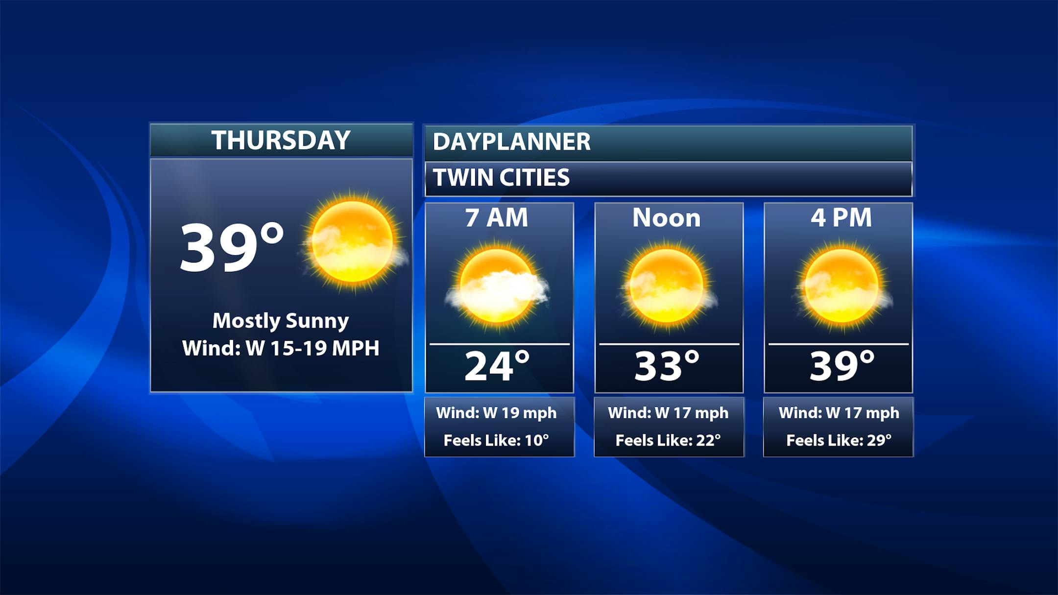
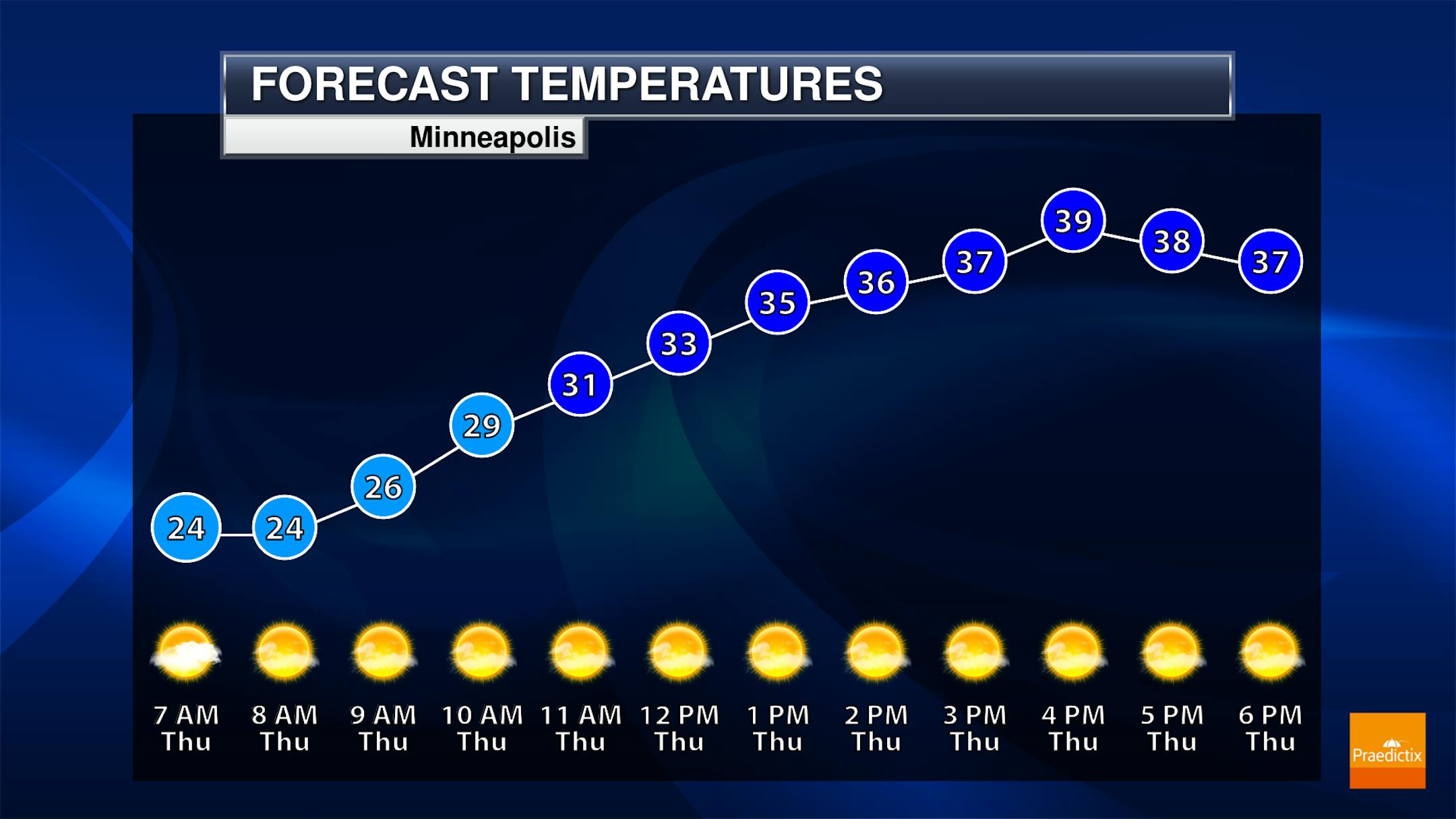
The system that brought rain and wintry weather to the metro Tuesday and Wednesday will be out of the picture as we head into Thursday. In fact, we'll see mainly sunny skies! It'll be a chilly day, though, as temperatures start off in the mid-20s and climb to around 40F. With strong west winds it'll feel more like the 20s in the afternoon - probably a good thing, then, that the Twins Home Opener was postponed!

(The Minnesota Star Tribune)

Winds stay strong during the day Thursday, out of the westerly direction with up to 30 mph wind gusts. These winds will finally start to calm down a little as we head toward Thursday Night.

(The Minnesota Star Tribune)

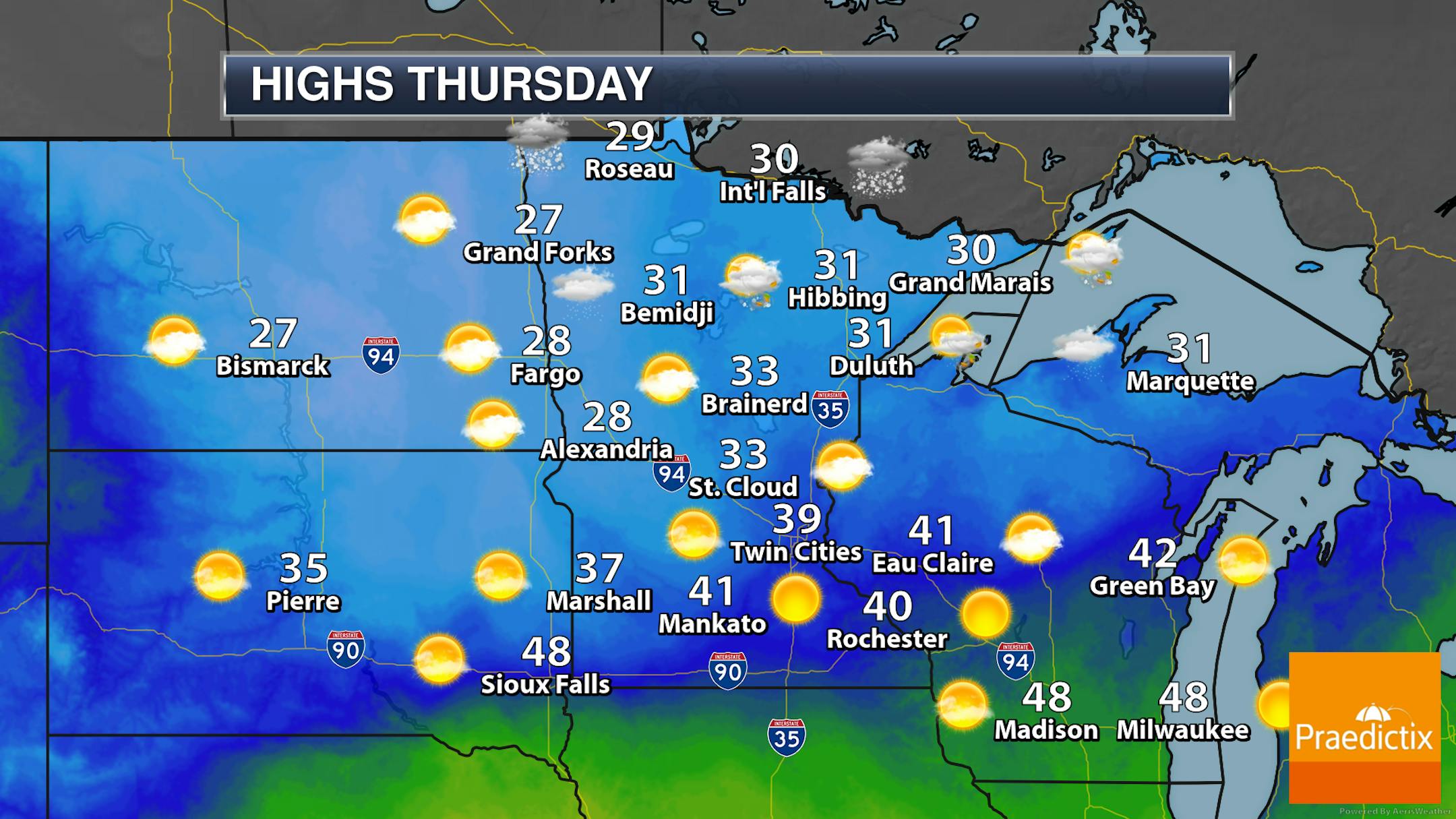
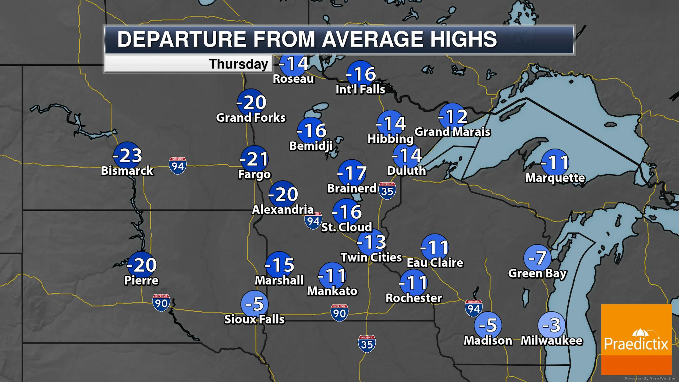
A few snow showers will linger across northern Minnesota Thursday, otherwise, fairly quiet and sunnier weather is expected as you head into central and southern portions of the state. Highs will range from near 30F in northern Minnesota to near 40F in southern parts. These highs are at least 10-20F degrees below average.

_______________________________________________

First 60s Of 2023 Expected For Easter Weekend

(The Minnesota Star Tribune)

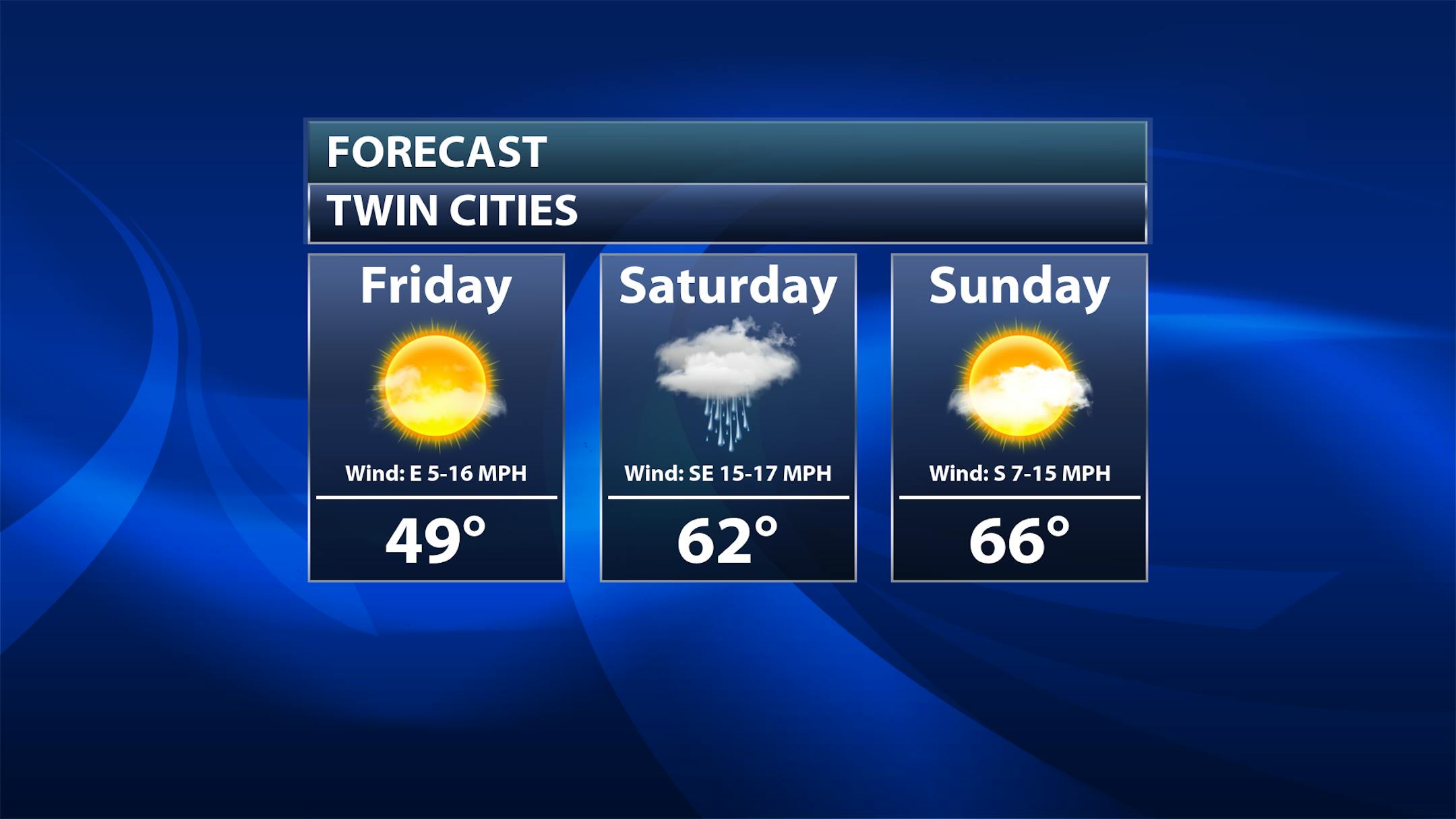
Good Friday: Warmer weather arrives with highs climbing to around 50F under sunny skies for Good Friday and the Twins Home Opener. It won't be as windy, with easterly winds at mainly 5-10 mph.

Friday Night into early Saturday: We will watch the chance of a few light rain or snow showers as we head through Friday Night into early Saturday across eastern Minnesota. Any amounts should be light.

Rest of Saturday: Mostly cloudy skies stick around, but we watch our first chance at 60F for 2023! That'll be on the back of strong southerly winds gusting to 25 mph.

Easter Sunday: We'll start off sunny, but I can't rule out a few afternoon showers around southern Minnesota. Highs look to climb into the mid-60s with southerly winds up to 15 mph.

(The Minnesota Star Tribune)

As we take a closer look at Easter Sunday, we should see dry conditions for any egg hunts in the morning hours. I can't rule out a slight chance of some rain across southern Minnesota in the afternoon hours as highs climb to the mid-60s.

_______________________________________________

First 60s This Weekend

(The Minnesota Star Tribune)

First 60F degree day/readings over the past 30 years

As shown above, the first 60F of the year is expected this weekend here in the Twin Cities. Over the past 30 years, the average first 60F occurs back in March - on March 22nd. The last time it didn't occur until April was back in 2018 (on April 21st).

_______________________________________________

First 70s Next Week?!?

(The Minnesota Star Tribune)

After hitting the 60s this week, the first 70s of the year are expected as we head into early next week! The average first 70F over the past 30 years is April 7th, so it'll only be slightly behind average. Some models had even hinted at our first 80F, but more recent runs have backed off on that a bit. However, 60s and 70s continue to be likely much of next week. Welcome to Spring!

_______________________________________________

A Rush of Spring Warmth On The Way
By Paul Douglas

"In the Spring, I have counted 136 different kinds of weather inside of 24 hours" Mark Twain wrote. That number may be low. All weather is NOT created equal. All things considered I'd rather welcome a warm front. Especially after a winter with 89.7" of snow.

Most of the glacier in your yard will be gone within 5-7 days. A few of those mega-drifts will still be there in early May, but I expect a very rapid meltdown as temperatures surge above 60F this weekend. Most of the sun's energy will go into melting snow vs. warming up the air in the coming days. By Monday and Tuesday, with more bare ground, we may see some 70s. Along with lost productivity, sudden sick days and the "April Flu".

Tropical Storm Floyd is winding down now - yesterday's intense storm whipped up wind gusts of 50 mph. A few light (rain) showers can't be ruled out this weekend. I see a few 70s next week. The European model predicts 80 next Thursday.

I hope friendly neighbors start waving at me with all their fingers. Ah why start now.

_______________________________________________

Paul's Extended Twin Cities Forecast

THURSDAY: Partly sunny, brisk. Wake up 24. High 38. Chance of precipitation 10%. Wind W 15-25 mph.

FRIDAY: Play ball! Sunny, less wind. Wake up 21. High 50. Chance of precipitation 0%. Wind SE 8-13 mph.

SATURDAY: Early shower, then lukewarm sunshine. Wake up 35. High 62. Chance of precipitation 40%. Wind S 10-20 mph.

SUNDAY: Springy with a quick PM shower. Wake up 45. High 64. Chance of precipitation 40%. Wind SW 10-20 mph.

MONDAY: Mild sunshine, feels like early May. Wake up 32. High 72. Chance of precipitation 10%. Wind SW 3-8 mph.

TUESDAY: Too nice to work. Lukewarm sun. Wake up 41. High 74. Chance of precipitation 0%. Wind S 15-25 mph.

WEDNESDAY: Mild sunshine, stray T-shower? Wake up 45. High 72. Chance of precipitation 30%. Wind SW 10-15 mph.

_______________________________________________

Minneapolis Weather Almanac And Sun Data
April 6th

(The Minnesota Star Tribune)

*Length Of Day: 13 hours, 2 minutes, and 7 seconds
*Daylight GAINED Since Yesterday: 3 minutes and 5 seconds

*When do we see 14 Hours of Daylight?: April 26th (14 hours, 1 minute, 49 seconds)
*When Is The Sunrise At/Before 6:30 AM? April 14th (6:30 AM)
*When Is The Sunset At/After 8 PM? April 17th (8:00 PM)

_______________________________________________

This Day in Weather History
April 6th

1991: The second of three consecutive record highs, all above 80 degrees, is set at MSP airport (86 on 4/6/1991).

1964: A snowstorm hits Minnesota with 9 inches at Fosston and 8.7 at Park Rapids.

_______________________________________________

National Weather Forecast

(The Minnesota Star Tribune)

The system plaguing the central United States with severe weather and blizzard conditions will move east on Thursday. With a frontal boundary stretched from the Northeast to lower Mississippi Valley, showers and thunderstorms can be expected with mixed precipitation in far northern New England. Some lingering snow showers or flurries will be possible in the upper Midwest. Meanwhile, a system near the northwestern U.S. coast will bring some rain and snow showers to the region.

(The Minnesota Star Tribune)

Very heavy rain is expected through the end of the week from eastern Texas to the Ohio River Valley, where at least 3-5" of rain could fall which will have the potential to lead to at least some isolated flash flooding. Snow that falls in the Upper Midwest and New England will mainly have fallen on Wednesday.

(The Minnesota Star Tribune)

For those looking forward to the Masters - it looks like a fairly wet (and eventually windy) forecast. Thursday does look mainly dry, with a chance of rain moving in overnight. Friday through Sunday has more than a 50% chance of showers and thunderstorms, with the highest odds occurring Saturday. Saturday could also feature wind gusts to at least 30 mph. We'll have to see if the wet weather across the tournament pushes the finish into early next week.

_______________________________________________

New York Could Change How It Measures Methane. Here's Why That's a Big Deal

More from Inside Climate News: "Environmentalists are criticizing New York Gov. Kathy Hochul for supporting a proposal to change how the state measures emissions of methane, the key component of natural gas and the world's second-leading contributor to climate change behind carbon dioxide. If passed, opponents say, the measure would undermine the state's climate law and set a dangerous precedent at a time when research shows the window to prevent runaway global warming is quickly closing. Under new legislation proposed last week by Sen. Kevin Parker, a state Democrat, New York would calculate the warming effect of methane gas on a 100-year time horizon rather than the 20-year time frame used by the state's landmark 2019 climate law. Proponents say the move will spare New Yorkers higher energy bills as utilities begin passing the cost of the energy transition onto consumers. Critics accuse Hochul of caving to fossil fuel lobbyists and call the proposal "magic math," with at least one estimate showing the change would require New York to cut roughly one-third fewer emissions this decade than currently required."

A buzzy new carbon removal plant is catching and releasing CO2

More from Canary Media: "Just northeast of Denver, a big new facility topped with giant industrial fans is sucking carbon dioxide directly from the sky. The machine is ostensibly one of the largest ​"direct air capture" units operating worldwide. Right now, however, all the carbon it captures is returned to the atmosphere. Global Thermostat, the company that built the facility, is ​"venting" the planet-warming gas until it can secure an ​"offtaker" for the CO2 captured by the new unit, Nicholas Eisenberger, head of market development, policy and engagement, told Canary Media. That could potentially include finding a company to sequester the carbon underground or use it to make valuable products, such as concrete and synthetic fuels. The project, which is capable of capturing 1,000 metric tons of CO2 per year, has been operating since late 2022."

Limiting warming to 2°C may avoid 80% of heat-related deaths in Middle East and North Africa

More from the London School of Hygiene & Tropical Medicine: "Over 80% of predicted heat-related deaths in the Middle East and North Africa (MENA) by the end of the century could be prevented if global warming is limited to 2°C, according to a modelling study published in The Lancet Planetary Health. Under high-emissions scenarios, approximately 123 people per 100,000 in MENA are predicted to die annually from heat-related causes by the end of the century — approximately 60-fold greater than current figures and much higher than predictions under similar scenarios worldwide. However, if global warming is instead limited to 2°C, over 80% of these deaths could be avoided, highlighting the urgent need for better adaption policies and a switch to renewable technologies. The findings come as the world prepares for COP28 in Dubai in November. MENA is one of the most climate-vulnerable regions of the world, with maximum temperatures predicted to rise to almost 50°C by the end of the century, potentially making some areas unliveable."

_______________________________________________

Follow me on:

Thanks for checking in and have a great day!

- D.J. Kayser

(The Minnesota Star Tribune)
about the writer

about the writer

D.J. Kayser

See Moreicon

More from No Section

See More

The man suspected of killing a Minnesota lawmaker and wounding another crawled to officers in surrender Sunday after they located him in the woods near his home, ending a massive, nearly two-day search that put the entire state on edge.

card image