When Will Our Mild Weather Bubble Pop?

The Dog Days of Winter have lost their growling bite. Two subzero nights? Data suggests we've saved about 9 percent on heat bills since September. A persistent Pacific signal has kept battery-draining cold confined to northern Canada in recent weeks. But our lukewarm luck may be running out.

All the weather models we study before placing our bets show a spell of much colder weather by the second and third week of February. Probably not record cold, but I could see a 6-12 day run of subzero nights, even a few daytime highs struggling to reach zero.

Pioneer Weather.

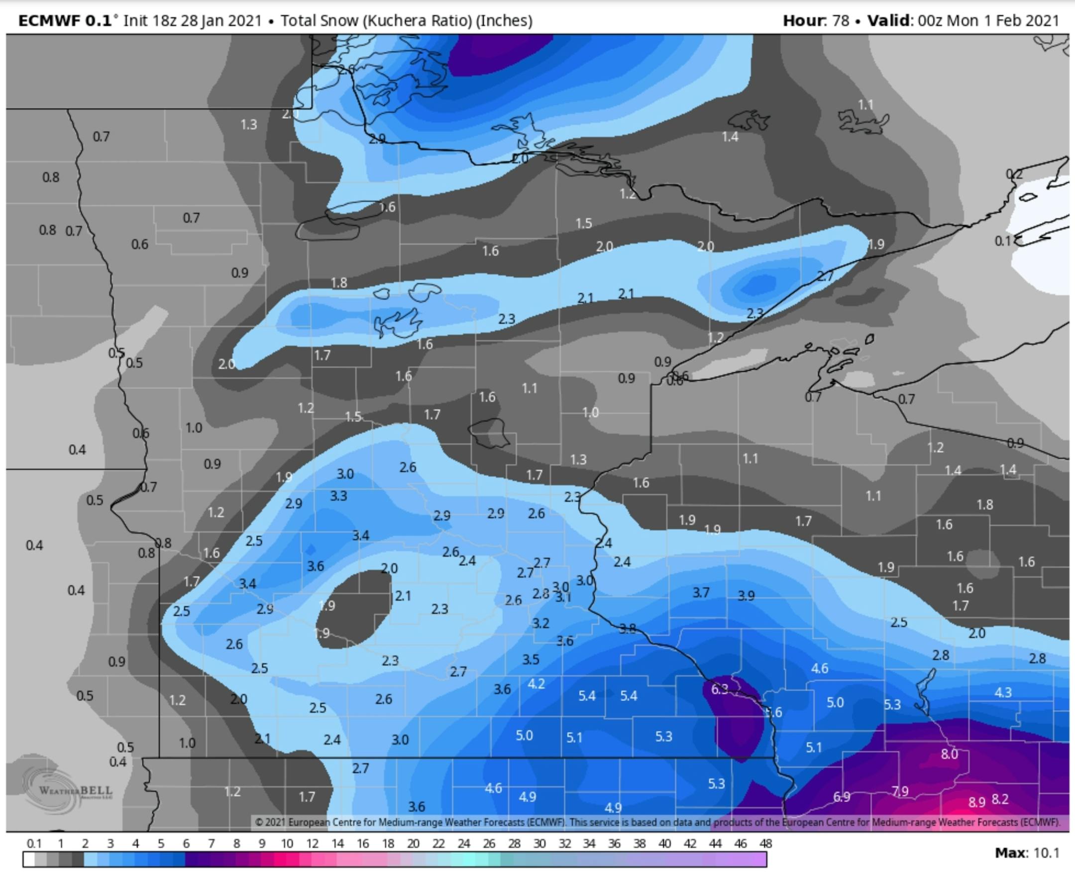
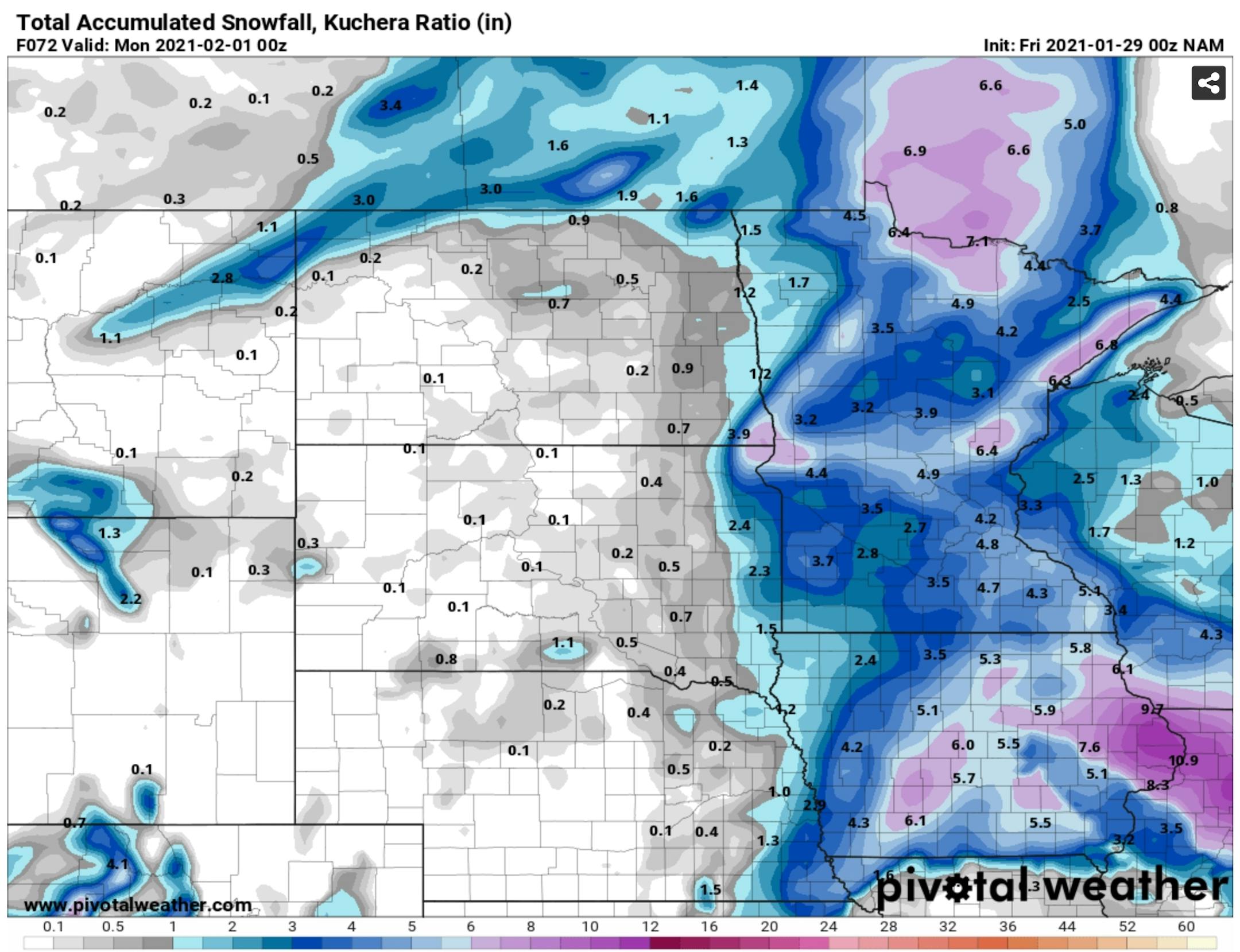
In the meantime temperatures mellow into the weekend and the potential for snow has diminished - the storm will track south (again), dumping up to a foot of snow from near Des Moines to Chicago. A few inches may fall in the Twin Cities, possibly enough to plow in some spots.

A much more significant ice and snowstorm is possible late next week, with a better chance of accumulation before bitter exhaust on the backside of the storm pulls a few eye-watering waves of numbing air into Minnesota 7-10 days out.

Fresh air!

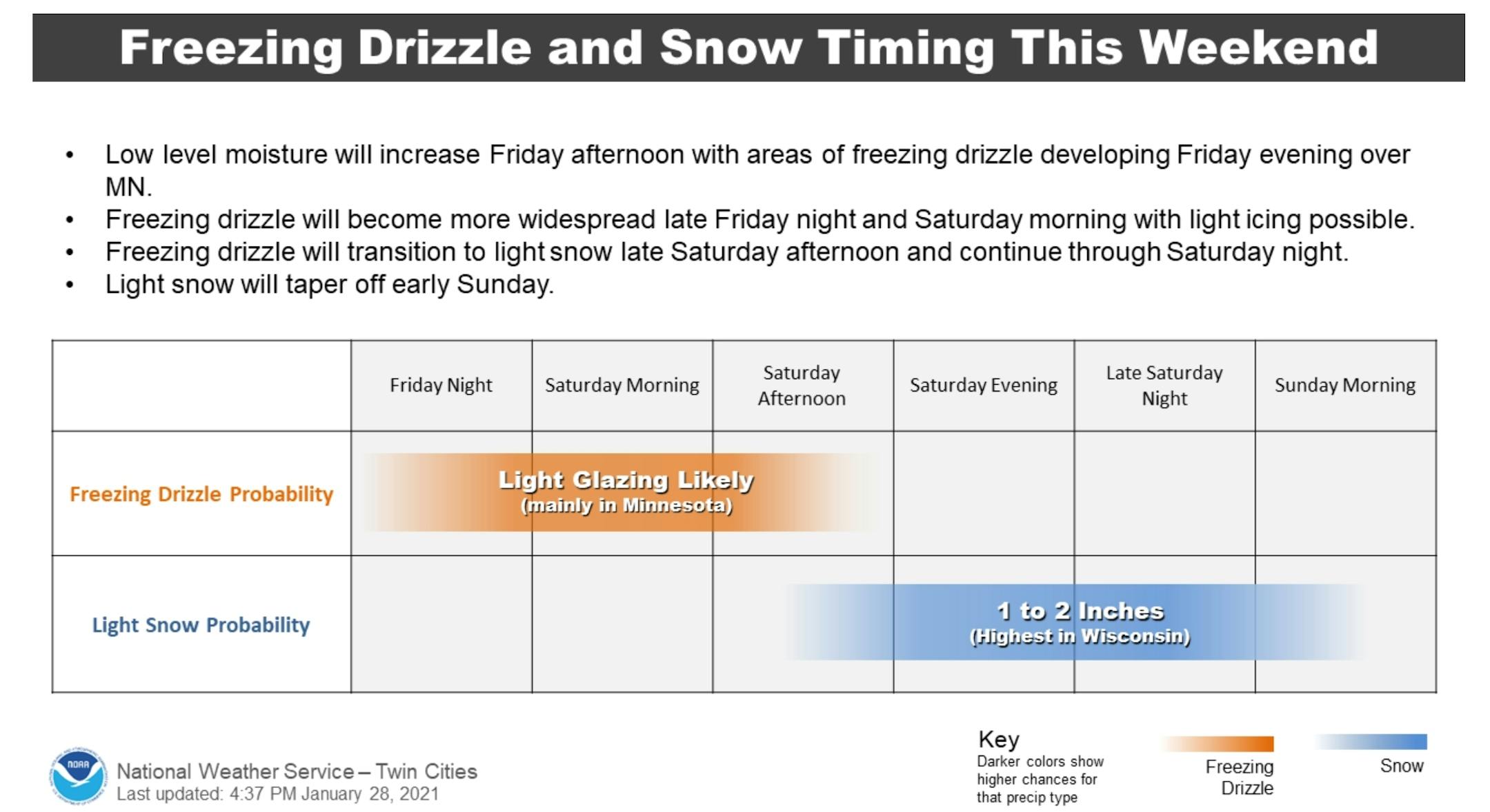
Freezing Drizzle to Light Snow. Drizzle may freeze on cold surface by tonight and Saturday morning, followed by a changeover to light snow Saturday into Sunday. A few inches may pile up by Sunday afternoon, but the heaviest amounts should stay south of Minnesota.

Another Low Ice Year Predicted on Lake Superior, Great Lakes. Star Tribune has an update: "As the sun rose over this corner of Lake Superior on Wednesday morning, the windchill was nearly 30 below. Open water at last disappeared under a thin layer of ice after stubbornly sticking it out through an unseasonably warm January. But just over the horizon, the waves remained. For the second season in a row, Lake Superior and the Great Lakes as a whole are expected to have below-average ice, which could increase shoreline erosion and threaten organisms that depend on ice cover, sending ripples through an ecosystem already challenged by warming waters. Even with the recent cold spell, just 6% of Lake Superior had ice cover at the start of the week, below the average of about 20% for this time of year. Last week's ice coverage was the lowest on those dates since the federal government started keeping track in 1973..."

Temperatures Trending Above Average Into Next Week. The average high at MSP has risen to 25F (from 23F in mid-January) and I expect temperatures consistently above average into next week. Weekend snowfall should be in the nuisance-plowable range, a few inches.

"Cold Enough". After relative warmth next week a series of arctic fronts make a pass at Minnesota, with a good chance of a few subzero nights (and even subzero days) the second and third week of February. Payback.

Bitter Air Poised Just To Our North. GFS guidance looking out nearly 2 weeks shows Siberian air over parts of western and central Canada, and there's a good chance that a series of clippers will drag increasingly numbing air into Minnesota in waves. Cold waves.

On the Sudden Stratospheric Warming and Polar Vortex Event of Early 2021. More perspective on how changes in the configuration of the jet stream may result in a spell of much colder air within 2-3 weeks, courtesy of NOAA Climate.gov: "...For the last several weeks, the stratospheric polar vortex has been weakening. What that means is the winds at 10 millibars (that's the layer of atmosphere about 18 miles above the surface), which normally move from west to east around the pole, began to slow down and temperatures began to warm up. By January 5, the winds actually switched direction and began moving in the opposite direction. The timing of wind reversal is considered the start of the sudden stratospheric warming event. SSWs can come in different shapes and sizes. While it's not entirely clear yet what led this SSW to occur, in the weeks leading up to the SSW there was a fairly persistent low pressure weather system over the North Pacific and high pressure weather system over the North Atlantic and Eurasia. This pattern represents a really large (planetary-scale) "atmospheric wave", which can grow bigger as it extends upward into the stratosphere given the right location and wind conditions..."

Atmospheric River in California Poses Debris-Flow Threat. The Capital Weather Gang at The Washington Post has perspective on the current west coast threat: "A potent series of winter storms along the West Coast is poised to produce as much as 10 feet of snow in the Sierra Nevada, along with the potential for a rare bout of heavy snow in the Sacramento Valley beginning Tuesday. These storms will also bring drenching rains to much of the California coast and other low-lying areas.In the wake of the state's worst wildfire season on record, these rains carry with them a high risk of debris flows in the vicinity of burn scars. They also showcase a feature of California's changing climate, with a seesaw between drought, heat and fires, and sudden winter storm-related flooding..."

Praedictix Briefing: Issued Thursday, January 28th, 2021:

Heavy Rain And Snow Continues To Impact The West Coast. Heavy rain and mountain snow continue to impact portions of California this morning, with several flood and debris flow reports south of the Bay Area since Midnight. In the past 48 hours, over three inches of rain has been reported in Lompoc, Watsonville, Columbia, and Monterey.

Rain To Move Southward. The stream of moisture that has been impacting central California will finally start to move southward today, eventually moving it toward the Los Angeles and San Diego areas tonight into early Friday. On Friday, the atmospheric river stream of moisture will end across the region, but showery activity will continue.

Heavy Rain Expected. The heaviest additional rain will continue to fall across portions of the central California coast the next couple of days. In these areas, at least an additional 2-4" of rain could fall. This system will bring the potential of downed trees, power outages, and travel delays due to urban roadway flooding. We will also be watching for mud and debris flows near recent burn scar areas.

Flood Risk. The flood risk will continue across portions of central and southern California the next few days with the heavy rain threat. A Moderate risk of excessive rain leading to flash flooding continues to be in place across portions of the central California coast today into tonight, as there could be areas that pick up a total of 5-15" of rain. Rainfall rates in this region could top 0.5"-1.0" per hour at times. Once again, the Dolan, River, and Carmel burn scars are at the greatest threat of debris flows in this area. As the rain moves southward later today into tonight, the Avila, Cave, Bobcat, El Dorado, Lake, Range2 and Bond burn scars in southern California could see debris flows with rainfall rates around 0.5" per hour. Flash Flood Watches stretch from the Bay Area into southern California.

Blizzard Warnings. Winter Storm Warnings and Blizzard Warnings remain in place up at higher elevations due to the heavy snow this river of moisture is bringing to the region, especially in the Sierra. These Blizzard Warnings include:

  • The west slope of the northern Sierra Nevada above 3,500 feet through 2 AM Friday for blizzard conditions with an additional 25-38" of snow and wind gusts of at least 50 mph.
  • The Greater Tahoe Area through 4 AM Friday for blizzard conditions with an additional 1-2 feet of snow and wind gusts to 40 mph in lower elevations and potentially 70 mph at times over ridges.
  • Mono County through 4 AM Friday for blizzard conditions with an additional 8-16" of snow (2-3 feet above 8,000 feet west of Highway 395) with wind gusts to 45 mph in the lower elevations and potentially 75 mph at times over ridges.

Across portions of the Sierras, several more feet of snow could fall over the next few days, continuing to lead to impossible travel conditions.

Watching The Central U.S. This Weekend. As we watch a low-pressure area move into the central United States this weekend, a heavy band of snow is expected to form across portions of the northern United States. Models have this band setting up near Chicago, with a greater than 50% probability of 4"+ of snow Saturday into Saturday night from eastern Iowa through northern Illinois into northern Indiana. We will have to watch the potential for Winter Storm Watches to be issued around Chicago heading toward the weekend.

Northeast Storm Potential By Early Next Week. As that system in the central U.S. heads east through the weekend, a new area of low pressure will form in the eastern Carolinas or just offshore and move up the east coast. This storm could bring snowy impacts to major cities along the I-95 corridor and in portions of the interior Northeast during the second half of the weekend into early next week, with already better than 50% odds of accumulating snow shown above for portions of the Mid-Atlantic and Northeast in the Sunday-Tuesday time frame. It is too early to project potential snow totals but depending on how quickly this storm develops and strengthens the snow could be quite heavy in some locations. We will keep you updated on this possible storm over the next few days.

D.J. Kayser, Meteorologist, Praedictix.

480,000 People Killed by Extreme Weather in Last 20 Years, Analysis Shows. CBS News has an update: "Almost half a million people have died in natural disasters linked to extreme weather events in the last 20 years, according to a new assessment of the direct threat posed to humanity by climate change. The mortality burden of climate-related catastrophes such as storms, flooding and heatwaves is overwhelmingly borne by developing countries. At the start of the Climate Adaptation Summit, held virtually this year due to the pandemic, the think tank Germanwatch calculated that these disasters have cost the global economy a staggering $2.56 trillion this century...

$2.4 Billion Price Tag for Natural Disasters in Canada in 2020. The Weather Network explains: "More than half of 2020's insured damages from weather disasters came from a single hailstorm in Alberta, whose $1.3-billion price tag made it the costliest in Canadian history. More than 80 per cent of that amount comes from just three events, all of them in Alberta. The list is topped by the June 13th storm that did $1.3 billion in hail damage in the Calgary area, the fourth costliest disaster in Canada's history, and the country's costliest hailstorm. Springtime flooding in Fort McMurray, at $562 billion, and a series of summer storms in central and southern Alberta that together did $221 million in damages, round out the top three..."

Using AI to Fight Wildfires. Hewlett Packard Enterprises hosted an interesting post; here's a clip: "...When Rao started researching wildfires, he realized they are affected by tree heat factors and meteorological drivers such as winds and precipitation. Humans, of course, are another factor, but so is fuel moisture. Rao found available research in predicting lightning and fire ignition but not in predicting fuel levels. "If I can tell how dry a forest is, I can predict how much fuel is available," he says. That's where leaves come in. There are a number of factors in a branch and leaf that help determine whether they will ignite. Rao and fellow researchers combined about 20 data pointsā€”including the leaf's color, the amount of microwaves transmitted from a satellite through that leaf, tree height, and the type of plant speciesā€”to determine a percentage of how wet the leaf or tree part is..."

General Motors Becomes First Major U.S. Automaker to Pledge All Electric Cars and SUVs by 2035. Wow. Here's an excerpt from The Washington Post (paywall): "General Motors said Thursday that it will end the sale of all gasoline and diesel powered passenger cars and light sports utility vehicles by 2035, marking an historic turning point for the iconic American automobile company and promising a future full of new electric vehicles for American motorists. GM chief executive Mary Barra, who antagonized many climate experts by embracing President Donald Trump's relaxation of fuel efficiency targets, said the company would eliminate all tailpipe emissions from light duty vehicles by that date. "As one of the world's largest automakers, we hope to set an example of responsible leadership in a world that is faced with climate change," she said on LinkedIn..."

Scientists Learn More About Thundersnow from Satellite Imagery. ABC News has an interesting post; here's an excerpt: "...The scarcity of thundersnow events, while likely compounding the delight of weather lovers who experience them, has also meant that scientists don't understand thundersnow as well as traditional summertime thunderstorms. Research has been limited by small or biased datasets, as well as less pressure to forecast thundersnow. But now researchers have a new tool at their disposal: A recently launched satellite instrument, called the Geostationary Lightning Mapper, or GLM, can gather images of lightning flashes day and night, summer and winter, over nearly an entire hemisphere. And scientists are tapping into this wealth of new data to unlock more of thundersnow's secrets..."

Has the Pandemic Transformed the Office Forever? We can only hope. Here's an excerpt from a good read at The New Yorker: "...In the past three decades, a series of quiet revolutions in design have changed the way offices are used, erasing former hierarchies of walls and cubicles and incorporating workplace methodologies from the technology industry into team-based, open-plan layouts. At the same time, digital tools such as e-mail, Excel, Google Docs, video conferencing, virtual whiteboarding, and chat channels like Slack have made a worker's presence in those offices less essential. The pandemic has collapsed these divergent trends into an existential question: What's an office for? Is it a place for newbies to learn from experienced colleagues? A way for bosses to oversee shirkers? A platform for collaboration? A source of friends and social life? A respite from the family? A reason to leave the house? It turns out that work, which is what the office was supposed to be for, is possible to do from somewhere else..."

FRIDAY: Mostly cloudy, breezy. Winds: SE 10-15. High: 27

SATURDAY: Light snow and flurries PM hours. Winds: E 10-15. Wake-up: 23. High: near 30

SUNDAY: Inch or two of snow early, PM clearing. Winds: N 8-13. Wake-up: 22. High: 31

MONDAY: Partly sunny and pleasant. Winds: SW 5-10. Wake-up: 21. High: 32

TUESDAY: Mix of clouds and sunshine. Winds: SE 8-13. Wake-up: 19. High: 32

WEDNESDAY: Mostly cloudy and breezy. Winds: SE 10-15. Wake-up: 24. High: 34

THURSDAY: Heavier wet snow or icy mix. Winds: NE 10-15. Wake-up: 30. High: 32

8" snow on the ground in the Twin Cities Thursday morning.

21 F. high yesterday at MSP.

25 F. average high on January 28.

22 F. high on January 28, 2020.

January 29, 1977: Due to the extreme cold, the St. Paul Winter Carnival is held indoors for the first time.

Climate Stories....

Biden, Emphasizing Job Creation, Signs Sweeping Climate Actions. Here's a clip from an explainer at The New York Times (paywall): "...Using the government's purchasing power to buy zero-emissions vehicles, Mr. Biden said, would help speed the transition away from gasoline-powered cars and ultimately lead to "one million new jobs in the American automobile industry." Over all, the text of his executive order mentions the word "jobs" 15 times. And in a clear echo of former President Barack Obama's claims that his climate policies would create millions of "green jobs," Mr. Biden also said his agenda would create "prevailing wage" employment and union jobs for workers to build 1.5 million new energy-efficient homes, to manufacture and install a half-million new electric-vehicle charging stations, and to seal off one million leaking oil and gas wells..."

Biden Suspends Oil and Gas Leasing in Executive Action. CNBC.com has more perspective: "President Joe Biden on Wednesday signed a series of executive orders that prioritize climate change across all levels of government and put the U.S. on track to curb planet-warming carbon emissions. Biden's orders direct the secretary of the Interior Department to halt new oil and natural gas leases on public lands and waters, and begin a thorough review of existing permits for fossil fuel development. In addition to the pause on leasing, Biden will direct the federal government to conserve 30% of federal lands and water by 2030 and find ways to double offshore wind production by that time..."

Adults Should Listen to Children to Understand the Severity of the Climate Crisis. Here is an excerpt of a post at Fortune: "...Where companies fall short, children will have a big role to play in driving consumer pressure for change among adults. Sometimes they even deploy their most potent powers of persuasion on executives directly. Some in the financial and fossil industry have agreed to aggressive green plans both to avert climate change in the long term and to avoid being "disowned' by their enlightened offspring in the short term. "Are you proud of what you do?" is what children pointedly ask of their parents in the corporate world. In the coming year, all adults in positions of powerā€”whether in the U.S. President's Cabinet or the corporate boardroomā€”should listen to young people's simple but serious demands..."

Century-Old Michigan Home Produces More Energy Than it Uses. A post at Yale Climate Connections caught my eye: "In 2006, Matt Grocoff bought a century-old house in Ann Arbor, Michigan. It had a south-facing roof, big windows, and heart pine floors. "It was our dream house," he says. But it lacked insulation, the windows leaked, and a 50-year-old furnace chugged away all winter long. "We had to put buckwheat pillows heated up in the microwave and stuffed down at the bottom of the bed to stay warm at night," Grocoff says. "And then we would get the utility bill, and it was like 350 bucks a month." Grocoff was determined to reduce energy waste and cut carbon pollution..."

Trends: Fewer Days and Nights Below Freezing. Climate Central analyzes the trends, locally and nationwide: "A Climate Central analysis reveals that 89% (217) of 245 cities have fewer cold nights since 1970. In addition, projections from Climate Impact Lab reveal that every state in the contiguous U.S. will see fewer days with below-freezing temperatures by midcentury (2040-2059). The decline in colder days and nights has consequences, including economic disruptions in winter recreation and the extension of disease-carrying tick and mosquito seasons...Results reveal that if emissions continue to go unchecked, every state in the contiguous U.S. will see fewer days with below-freezing temperatures by midcentury (2040-2059)..."

Global Ice Loss on Pace to Drive Worst-Case Sea Level Rise. Another compelling excuse to rent, not purchase, coastal properties from Inside Climate News: "...The ice sheets are now following the worst-case climate warming scenarios set out by the Intergovernmental Panel on Climate Change," he said. "Sea-level rise on this scale will have very serious impacts on coastal communities this century." Sea level has gone up about eight or nine inches since 1880. It's likely to rise at least 12 inches, and could rise by as much as 8.2 feet by 2100, according to recent estimates by the National Oceanic and Atmospheric Administration. The Intergovernmental Panel on Climate Change estimates a rise of between two and three feet by 2100 if global warming is kept well below two degrees Celsius (3.6 degrees Fahrenheit), or three to five feet if temperatures rise past that..."

BlackRock's Larry Fink to CEOs: Get Serious on Net-Zero Targets or Else. Climate action may not be optional for U.S. businesses going forward, according to a post at Fortune: "Larry Fink, the chief executive of the world's largest asset manager, is doubling down on a strategy of integrating climate risks into investing, telling his fellow CEOs he expects companies in which BlackRock invests to make clear how they will achieve their net zero emissions goals. In his annual letter published on Tuesday, Fink also said that the companies would need to lay out how exactly such a target is incorporated within their long-term strategies, and how it will be reviewed and measured by individual boards. In an accompanying letter to clients, BlackRock warned it would take action against those companies that have a high carbon intensity, and which do not align with its own net zero goals..."