NATIONAL TAX DAY – April 15
"April 15th of each year is National Tax Day. In the United States, the term "tax day" refers to the day on which individual income tax returns are due to the federal government. The day may also refer to April 15th for state tax returns. The Federal income tax filing deadline is midnight on April 15th of every year, with extensions occurring when the 15th lands on a Saturday, Sunday, or a holiday. In those circumstances, the returns are due the first succeeding day which is not a Saturday, Sunday, or a holiday. These dates can differ depending on the residence as well. Some years, due to extenuating circumstances such as natural disasters, more significant extensions have been granted by the Federal Government. HOW TO OBSERVE NATIONAL TAX DAY. Complete and file your taxes. Quote Benjamin Franklin: Nothing is certain but death, and taxes. Save a copy of your tax return in a safe place. Give a shout-out to your tax preparer. Use #NationalTaxDay to post on social media."

It Was A Very Warm Week of April
It took a while, but we finally got some much needed spring warmth and it came in a hurry with our first 50F, 60F, 70F and 80F, all happening within a week or so. Our first 50F came nearly 1 month later than normal, while our first 60F came nearly 2 weeks later than normal. Our first 70F occurred on Monday, which is only a few days, and our first 80F came nearly 2 to 3 weeks ahead of schedule... How about that?!

Record Highs This Week Too!
We even spotted a couple of record highs this week.
Wednesday recorded an 88F high, besting the previous record for April 12th of 83F set in 1931.
Thursday recorded an 87F high besting the previous record for April 13th of 86F set in 2006.
Friday's record high was 89F set in 2003, but we didn't quite make it...

General Thunderstorm Risk on Saturday
Scattered showers are expected across the region on Saturday with perhaps enough instability to kick out a rumble of thunder to two. According to NOAA's Storm Prediction Center, we just have a general thunderstorm risk, nothing severe...

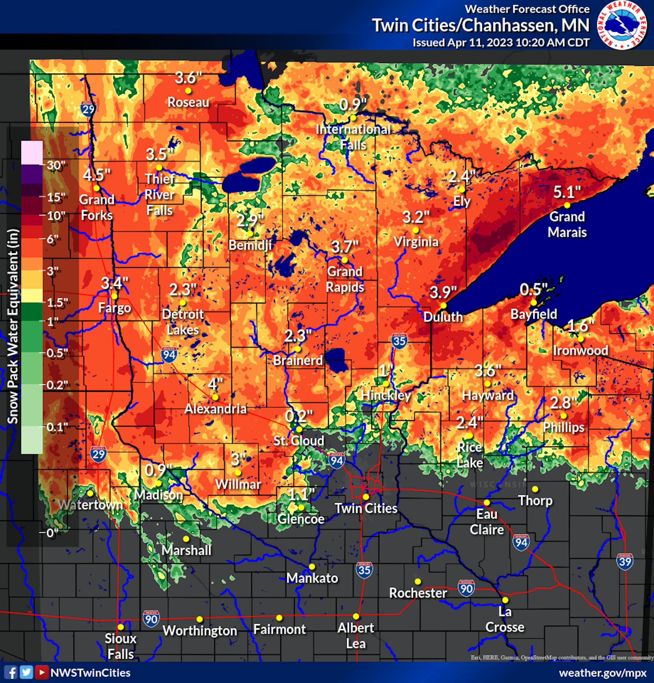
Precipitation Potential
According to NOAA's WPC, the extended precipitation shows some fairly impressive amounts across parts of the state. From PM Friday to AM Monday, there could be some 1" liquid tallies. While most of us will take the additional precipitation, flood concerns remain high so the additional heavy precipitation is not all that welcomed until we can get passed the flooding threat this spring.

Weekend Snowfall Potential
According to NWS's NDFD, there could be a slushy coating of snow by early AM Sunday. Some models suggest a heavier batch of snow through AM Sunday, but ground temps are quite warm, so much of the snow should melt on contact.

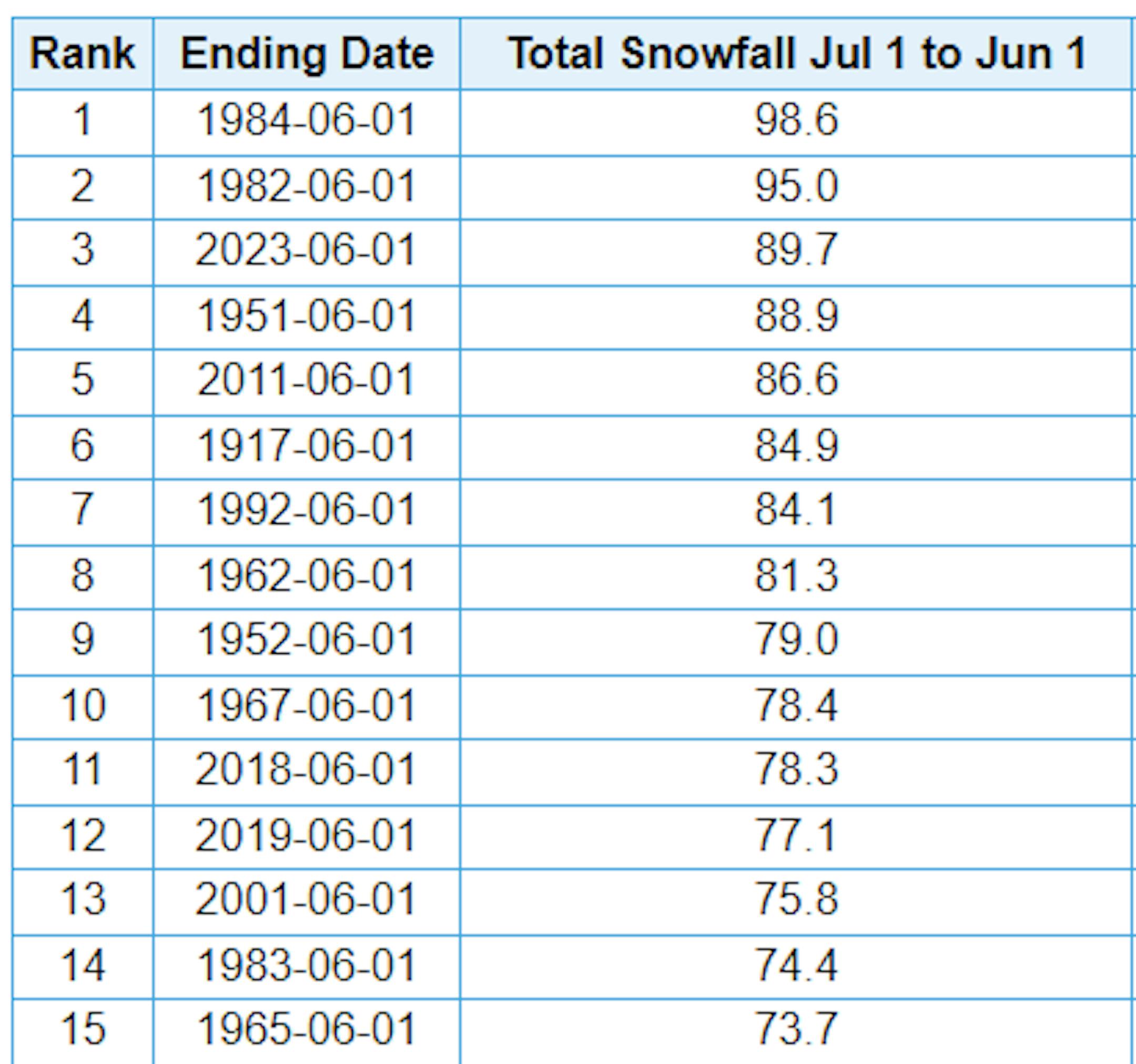
3rd Snowiest Winter on Record
Just a reminder that MSP has seen nearly 90" of snow this season, which is the 3rd snowiest winter season on record. We need 5.4" more get into the 2nd spot and 9" to get into the top spot. If you're wondering, the latest measurable snow (0.1") on record at MSP was on May 24th set in 1925. The snow season isn't quite over just yet... Stay tuned.