
"The U.S. just had its 7th-warmest September on record"
"Last month marked by heat waves, tropical systems and flooding rain. September 2023 was remarkably warm and quite dry across the contiguous United States. The month also brought record heat and flooding rains to parts of the nation, according to scientists from NOAA's National Centers for Environmental Information. Below are highlights from NOAA's September U.S. climate report: Climate by the numbers September 2023 The average September temperature across the contiguous U.S. was 67.8 degrees F — 2.9 degrees above the 20th-century average — making it the seventh-warmest September in NOAA's 129-year climate record. New Mexico and Texas both saw their warmest Septembers on record, while Minnesota had its second warmest. An additional 10 states saw their top-10 warmest Septembers on record. The average precipitation last month was 2.10 inches (0.39 of an inch below average), ranking the month in the driest third of all Septembers in the historical record. Ohio had its fifth-driest September on record with Indiana and Michigan seeing a top-10 driest September on record. Connecticut had its third-wettest September on record, while Nevada and New Jersey both had one of their top-10 wettest Septembers."
2023 Billion Dollar Disasters
"Year to date (YTD, January through September 2023) - The year-to-date average temperature for the contiguous U.S. was 57.0 degrees F — 1.9 degrees above average — ranking as the 10th-warmest such YTD on record. Mississippi and Florida had their warmest January–September period on record while Delaware and Maryland saw their second warmest. An additional 24 states had a top-10 warmest such YTD on record. No state experienced a top-10 coldest event for this nine-month period. Looking at the year-to-date average precipitation, the total was 23.32 inches (0.12 of an inch above average), ranking in the middle third of the record. Massachusetts ranked second wettest, while Connecticut ranked third wettest on record for this YTD. Six additional states — Maine, Nevada, New Hampshire, Rhode Island, Vermont and Wyoming — ranked among their top-10 wettest for this period. Conversely, Iowa ranked 10th driest for this nine-month period."

A Sizeable Soaking Later This Week
Here's the simulated radar from 7AM Thursday to 7AM Saturday, which shows a sizeable storm system moving through the Midwest. This could be a fairly good soaking for many with fairly strong winds.

Extended Precipitation Outlook
Here's the extended precipitation outlook through the weekend, which shows widespread 1" to 2" tallies across the southern half of the state. Some locations could potentially see up to 3", mainly across the southwestern part of the state. This could be another drought denting rain for many, but still not enough to get out of the drought.

90 Day Precipitation Anomaly
Thanks to some recent heavy rains parts of the state are now in a surplus over the last 90 days. Some of the biggest surpluses (which aren't many) are showing up in blue in pockets along and north of the Twin Cities and also just east of the metro in western Wisconsin.

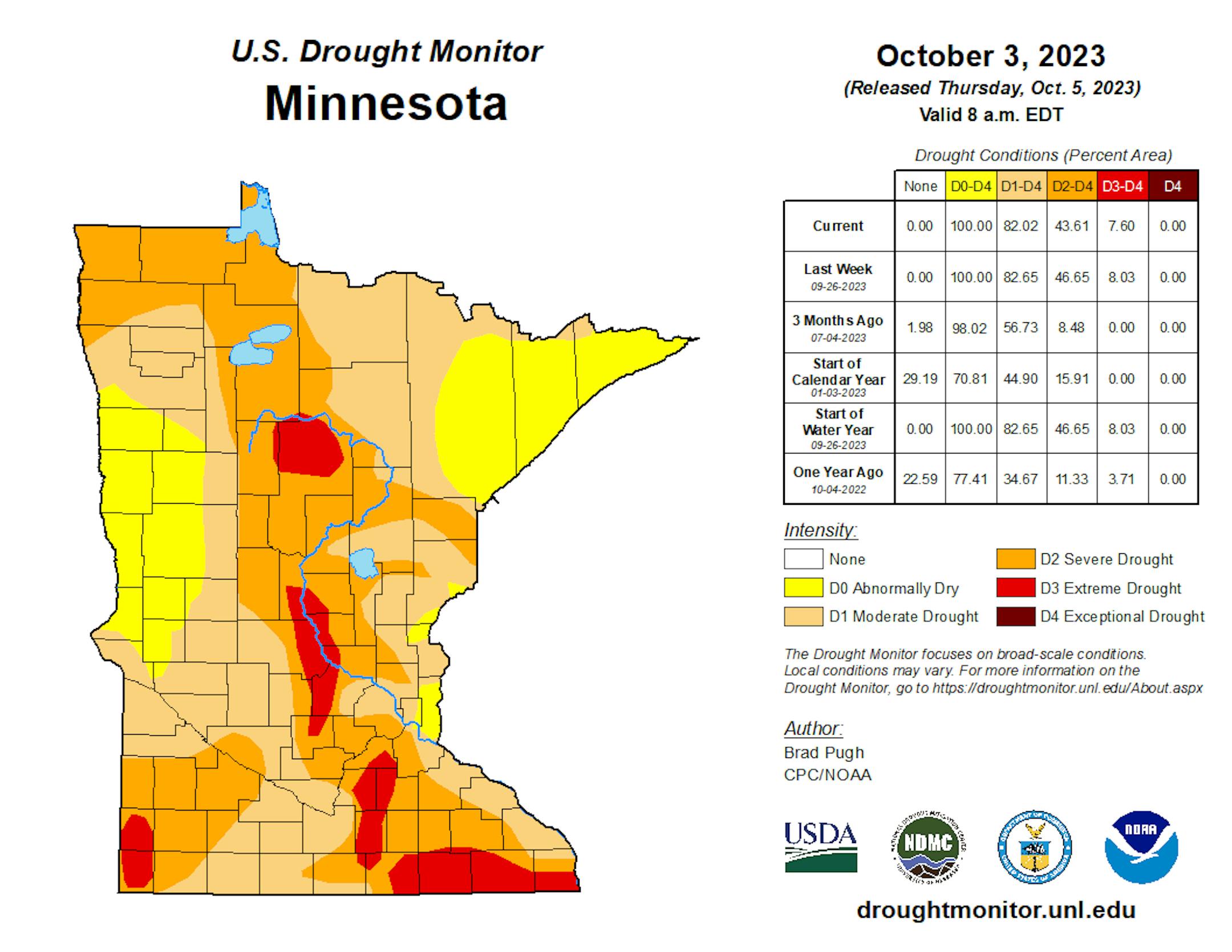
Drought Update
Recent heavy rains have helped the drought situation quite a bit in spots across the state. With that being said, we're still in a drought across much of the state with nearly 8% under an extreme drought.


