Driest September on Record at MSP
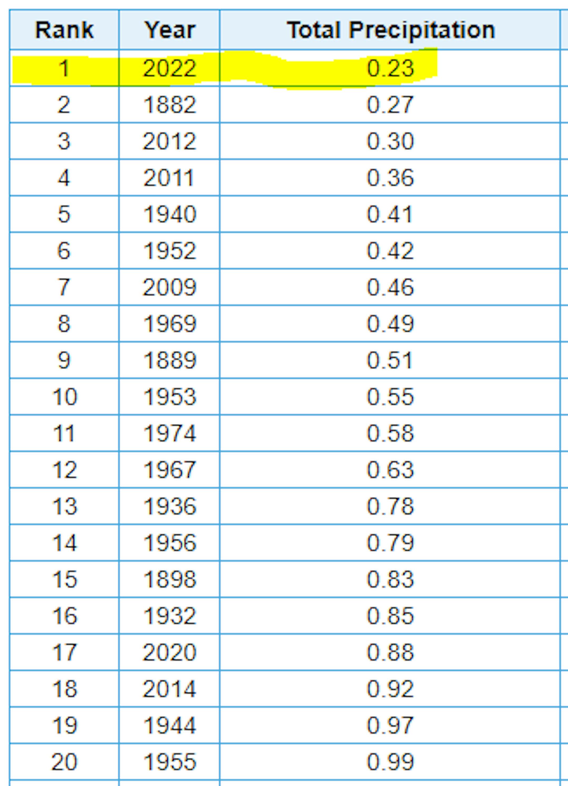
Well this kind of snuck up on us, but did you realize that MSP only had a 0.25" of rain for the entire month of September? This will rank as the driest September in recorded history!
Dry September Around the Region
Despite a few pockets of heavy rain here and there, September really was a dry month for many across the Midwest. All of the climate sites in Minnesota were below average with the biggest deficit in the Twin Cities, which ranked as the driest September on record.

Precipitation Departure From Average Since Jan. 1st
Here's the precipitation departure from average across the Midwest since January 1st. Note that there are a few communities that are dealing with surpluses, but for the most part, folks from the Twin Cities to Sioux Falls, SD are running below average. Minneapolis is nearly -7.70" below average, which is good enough for the 23rd driest start to any year in recorded history.

Severe Drought Continues in the Metro
According to the US Drought Monitor (updated September 27th), severe drought continues in the Twin Cities. Areas of moderate to severe drought stretch from the Twin Cities to the MN River Valley, where precipitation amounts are running several inches below average since January 1st.

Mostly Dry Extended Forecast
Here's the precipitation outlook through over the next several days, which shows very little rainfall across the region.

Little Rain Chance Into Early October
Here's the weather outlook through the middle part of next week, which shows isolated rain chances possible, but it doesn't appear that any appreciative amounts will be possible. There is more substantial cooldown that will move through midweek with much cooler air in place during the 2nd half of the week.

"41 Surreal Pictures And Videos Showing The Unreal Devastation Left Behind By Hurricane Ian"
Hurricane Ian was one of the strongest hurricanes to ever hit the Florida coast. In terms of max winds, this will tie with Charlie, but Matthew, Andrew and the Labor Day Hurricane were stronger. Many communities on the west coast of Florida and especially around Fort Myers saw catastrophic damage. The images coming out of Florida are astonishing and heart-breaking. Buzzfeed compiled some unreal images HERE:
Ian Makes Another Landfall on Friday
Here's a look at Hurricane Ian from PM Friday as it made a 2nd U.S. landfall near Georgetown, SC as a category 1 storm with 85mph winds. This was the first South Carolina landfalling hurricane since Matthew in 2016. Gusty winds and heavy rainfall will be possible over the weekend through the Mid-Atlantic States, where some 2" to 5" rainfall tallies can't be ruled out.