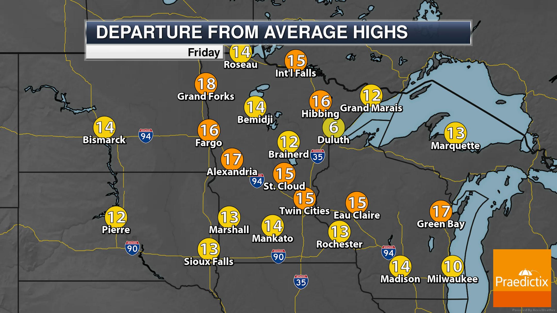
Abnormally Dry Conditions Expanding Across Minnesota

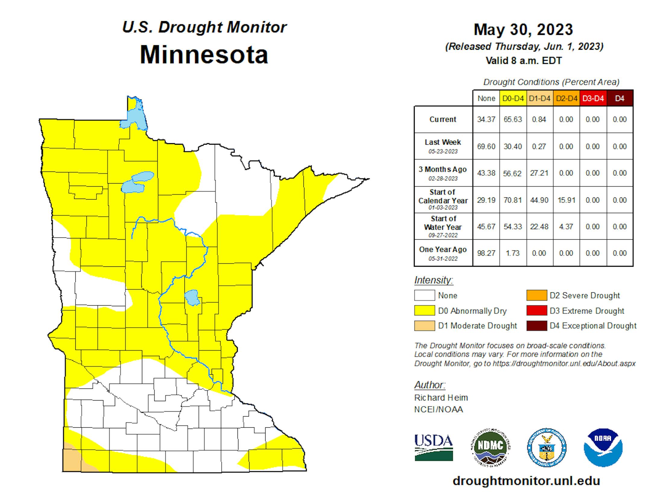
Over the past week, abnormally dry conditions have quickly expanded across the state. 65.63% of the state is now considered abnormally dry according to the Drought Monitor issued on Thursday, up from 30.4% last week. The amount of the state under Moderate Drought (down in southwestern Minnesota) also slightly increased to 0.84% (up from 0.27%).

_______________________________________________

Friday: Another Hot Day With Afternoon Storms

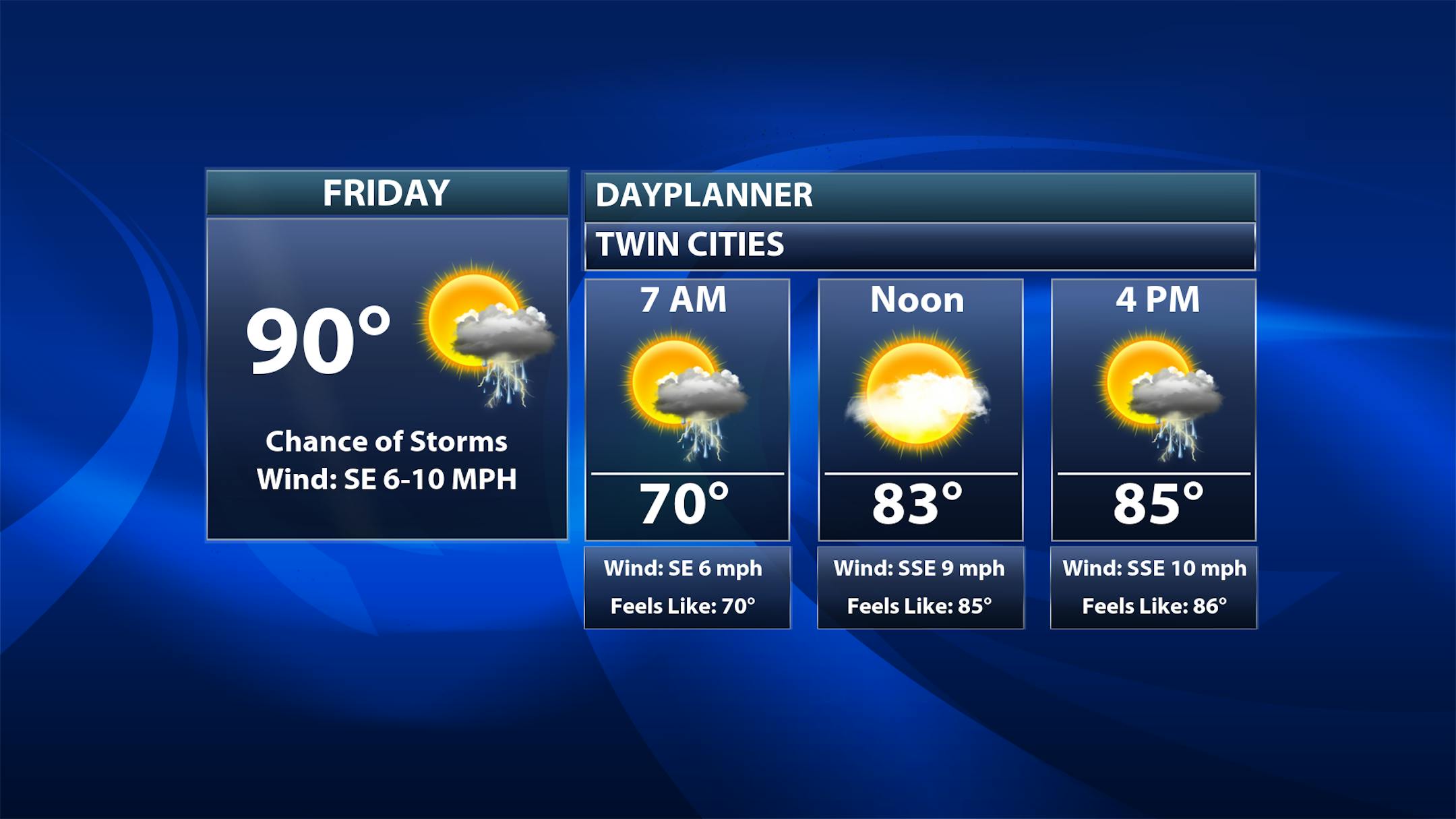
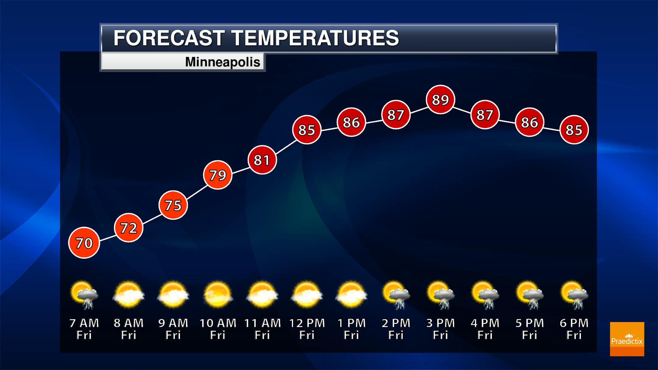
For your second day of June on Friday, we'll be watching hot temperatures once again with morning lows around 70F and highs around 90F in the metro. Our record high is 93F, so we could flirt with records. An isolated storm can't be ruled out really early in the morning (though I think the odds are low). Better chances of some storms will pop up as we head into the afternoon and evening hours across the region.

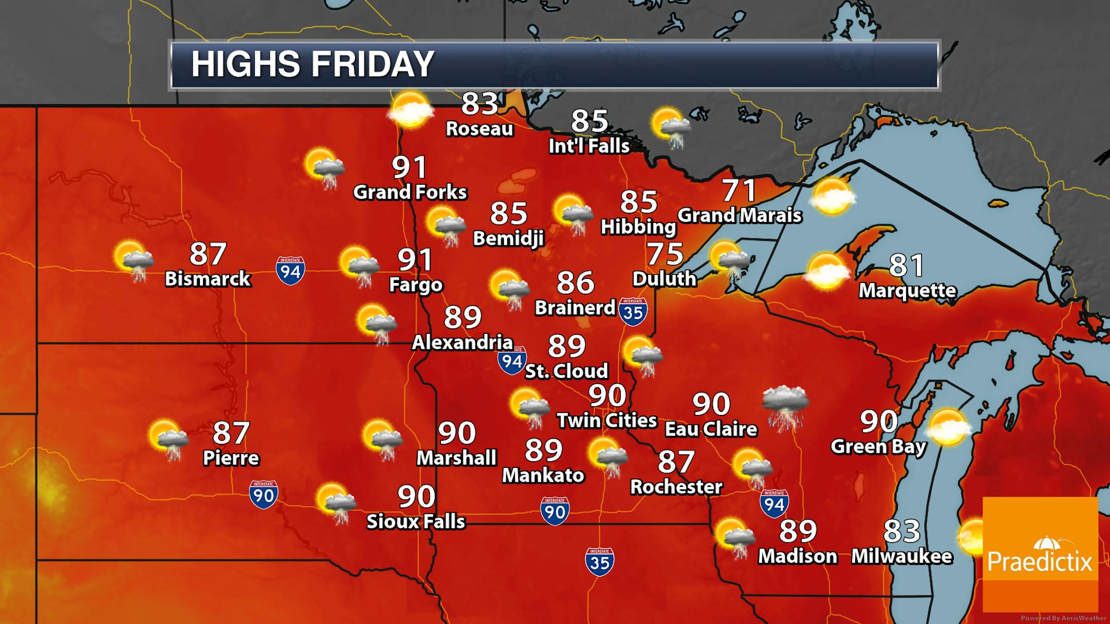
Most of the state will have that afternoon/evening pop-up storm potential, though similar to the past few days, not everyone will see needed rainfall. Highs will range from the 70s along the North Shore (thanks to lake-influenced air) to the 80s and low 90s across the rest of the state.

_______________________________________________

Warm With Scattered Storm Chances Into The Weekend

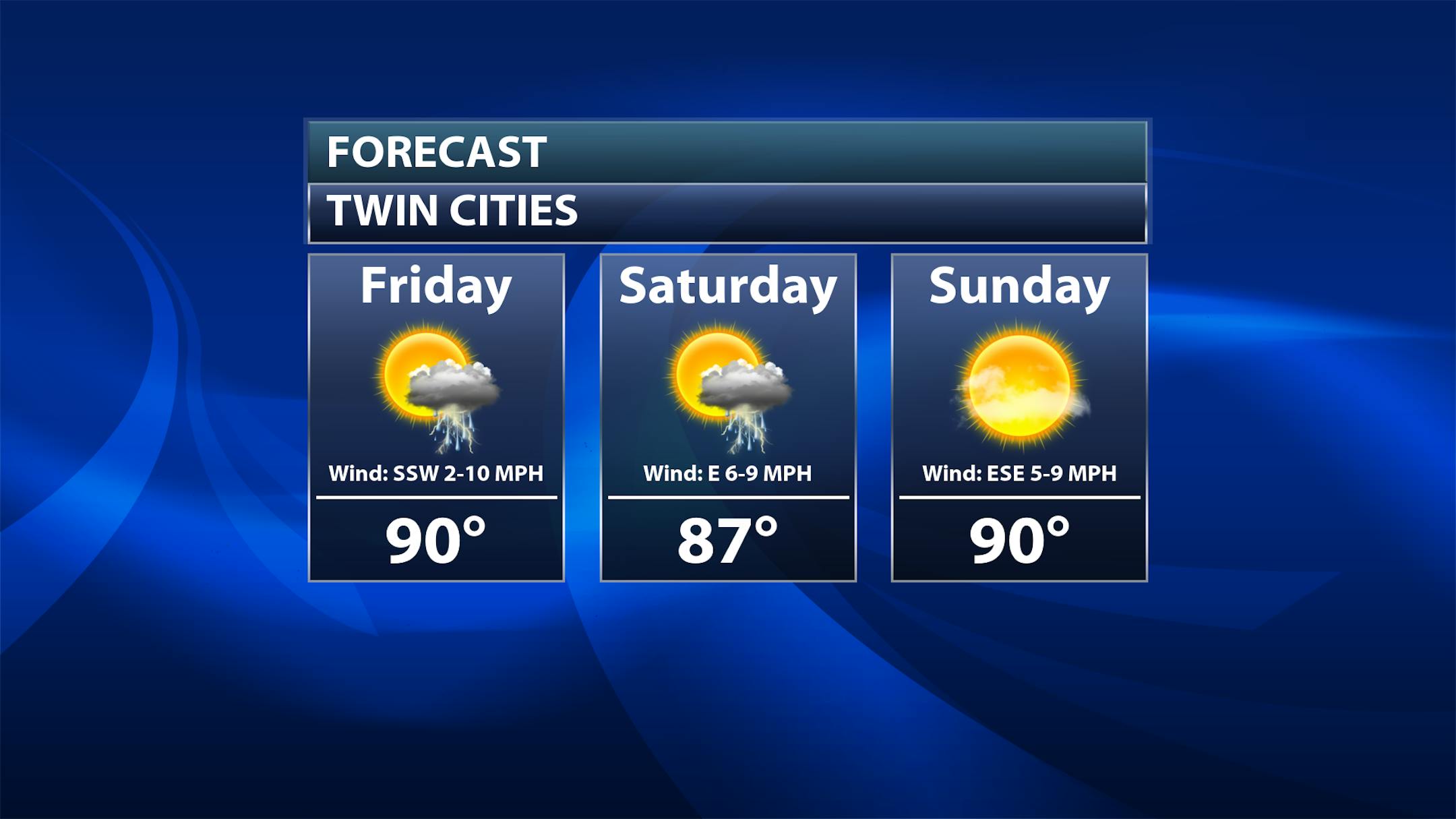
As we look toward the weekend, Saturday temperatures take a slight step backward into the upper 80s as we continue to watch scattered storms during the afternoon and evening hours (chances around 50%). On Sunday, mainly sunny skies are expected as highs climb back to 90F. We still will watch some isolated storm chances in the afternoon Sunday, but those chances are only around 20%.

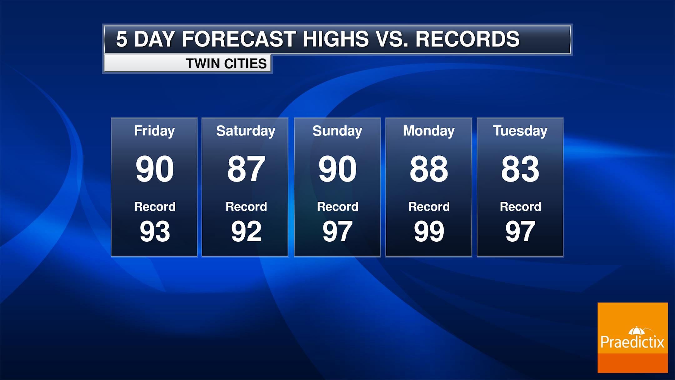
Friday will be the best current opportunity to potentially see a record high as we reach the low 90s once again. With Saturday's high now projected not to make 90F, the potential of seeing a record has decreased. As we get back to the 90s Sunday, record highs climb into the upper 90s, making records less obtainable.

_______________________________________________

Slight Cool Down Next Week

For those of you who don't like highs in the 90s (I'm counting myself in this sector), there could be a slight cool down in the forecast as we head into next week. Notice how I call it "slight" - it'll only be back into the low to mid-80s, still several degrees above average. But… small victories for those that don't like the heat?

_______________________________________________

May Summary: (Mostly) Dry And Warm

It was a warm and dry May here in the Twin Cities. Our average temperature of 64.2F was 4.7F degrees above average, making it the sixth warmest May on record. On the precipitation side, only 1.62" fell, making it the 20th driest May.

Most of the state was below average precipitation-wise during the month of May, including a tie for the third driest May on record for Duluth. The exception was in southern Minnesota, where heavy rain toward the middle of the month (including 9.14" near Comfrey) led to flooding and above-average amounts for May.

_______________________________________________

June Looks Warm & Dry

On Wednesday, the Climate Prediction Center (CPC) put out its updated outlooks for the month of June. On the temperature side of the scale, they are calling for higher odds of above-average temperatures across the upper Midwest, including here in Minnesota.

Meanwhile, below-average precipitation is currently forecasted from the CPC across the Great Lakes, including Minnesota. Those sprinklers look to potentially get a workout this month.

_______________________________________________

Statistical Odds Favor A Hotter Summer
By Paul Douglas

Welcome to what I suspect will be the definition of a "stinking hot summer". Mother Nature's way of apologizing for a foul and slushy April. There is some science to back this up.

Turns out hot summers start early. Dr. Kenny Blumenfeld is Minnesota's Senior Climatologist, with 151 years of data to analyze. He found that when MSP experiences at least 2 days of 90-degree heat in May, the summer that follows has an average of 23 days of 90s. The 30-year average is 13 days at/above 90F. We saw 90F the last 2 days of May this year, so odds of hot and sweaty are greater. There is a very strong correlation.

How many different ways can you say "Partly sunny, sticky and hot with a risk of a late-day T-storm"? A humid, unstable airmass stays with us into early next week with highs near 90F each day - the best chance of growls of thunder coming around the dinner hour. If you do see rain consider yourself extra-blessed. It's drying out again.

From 90.3" snow to a hot, sauna-like summer? Sounds about right.

_______________________________________________

Paul's Extended Twin Cities Forecast

FRIDAY: Sweaty sun, late thunder? Wake up 70. High 90. Chance of precipitation 40%. Wind SE 8-13 mph.

SATURDAY: Ditto. Sticky sun, T-storm later. Wake up 70. High 90. Chance of precipitation 30%. Wind SE 8-13 mph.

SUNDAY: Hot sunshine, probably dry. Wake up 72. High 92. Chance of precipitation 10%. Wind S 5-10 mph.

MONDAY: Hazy sun, isolated T-shower. Wake up 71. High 90. Chance of precipitation 20%. Wind NE 5-10 mph.

TUESDAY: Morning sun, few late PM rumbles. Wake up 67. High 89. Chance of precipitation 30%. Wind N 5-10 mph.

WEDNESDAY: Mix of clouds and sunshine, cooler. Wake up 66. High 85. Chance of precipitation 20%. Wind E 7-12 mph.

THURSDAY: Warm sunshine. Wake up 65. High 88. Chance of precipitation 20%. Wind S 8-13 mph.

_______________________________________________

Minneapolis Weather Almanac And Sun Data
June 2nd

*Length Of Day: 15 hours, 23 minutes, and 58 seconds
*Daylight GAINED Since Yesterday: 1 minute and 21 seconds

*Most Sunlight In A Day: June 21st (15 hours, 36 minutes, 51 seconds)
*Earliest Sunrises Of The Year: June 13th-17th (5:25 AM)
*Earliest Sunsets Of The Year: June 21st-July 2nd (9:03 PM)
_______________________________________________

This Day in Weather History
June 2nd

1945: Snow and sleet pile up to 4.5 inches at Tower.

1898: Heavy rain falls across Minnesota. Just over 7 inches is reported at Pine River Dam.

_______________________________________________

National Weather Forecast

We are closely tracking an area of low pressure in the Gulf of Mexico near Florida on Friday that'll bring the potential for heavy downpours. Whether or not something forms, this low will sag south over the next few days. On Friday, we're also tracking scattered storms from the Rockies and Great Basin to the mid-section of the nation (with some snow mixing in in the higher terrain of the Rockies). A system near New England will also produce storm activity there. Several record highs could be broken from the western Great Lakes into the Northeast.

Heavy rain from that potential tropical system in the Gulf will impact the Florida peninsula into the weekend, with some areas seeing over 3" potentially. Another area that has the potential of 3-5" of rain through the first half of the weekend will be from the Texas Panhandle to southern Kansas.

_______________________________________________

A New Hurricane Season Begins With Forecasts For Less Activity but More Uncertainty

More from Inside Climate News: "Dana Land and his wife, Ava, live on a bend in the St. Johns River, the water lapping not far from their back door. For a dozen years, the river brought them peace and joy. Then last fall, Hurricanes Ian and Nicole transformed the waterway into a threat that flooded their home for weeks. As a new Atlantic hurricane season begins on June 1, the Lands are still working on repairs of their two-story wood frame house. "I hope we don't have double back-to-back hurricanes again, but I've made these changes to try to make life livable here the next time," Dana Land said. While the Lands press ahead, however, the confluence of two important climate factors has meteorologists puzzling over what this hurricane season could bring. "What makes this forecast hard is that we are potentially looking at something we haven't seen before," said Phil Klotzbach, a senior research scientist at Colorado State University's Department of Atmospheric Science. "We have a strong El Niño but a record or close-to-record warm Atlantic. That makes it tough just because we haven't seen that historically.""

NASA Researchers Detect Tsunamis by Their Rumble in the Atmosphere

More from NASA: "Triggered by earthquakes, undersea volcanoes, and other Earth-shaking forces, tsunamis can devastate coastal communities. And when it comes to providing advance warning, every second counts. Scientists at NASA's Jet Propulsion Laboratory are testing a novel approach to detect – from the far reaches of the atmosphere – the ocean's deadliest waves. Called GUARDIAN (GNSS Upper Atmospheric Real-time Disaster Information and Alert Network), the experimental monitoring system taps into data from clusters of GPS and other wayfinding satellites orbiting our planet. Collectively, these clusters are known as global navigational satellite systems, or GNSS. Their radio signals travel to hundreds of scientific ground stations around the world, and that data is crunched by JPL's Global Differential GPS (GDGPS) network, which improves real-time positional accuracy down to a few inches (roughly 10 centimeters)."

Earth's health failing in seven out of eight key measures, say scientists

More from The Guardian: "Human activity has pushed the world into the danger zone in seven out of eight newly demarcated indicators of planetary safety and justice, according to a groundbreaking analysis of the Earth's wellbeing. Going beyond climate disruption, the report by the Earth Commission group of scientists presents disturbing evidence that our planet faces growing crises of water availability, nutrient loading, ecosystem maintenance and aerosol pollution. These pose threats to the stability of life-support systems and worsen social equality. The study, which was published in Nature on Wednesday, is the most ambitious attempt yet to combine vital signs of planetary health with indicators of human welfare."

_______________________________________________

Follow me on:

Thanks for checking in and have a great day!

- D.J. Kayser